Aird Chadhachan

Hill, Mountain in Inverness-shire

Scotland

Aird Chadhachan

Sgurr a' Choire-bheithe Looking west from the summit of Aird Chadhachan (474m). Sgurr a' Choire-bheithe falls short of Munro height by just a metre! Michael took this photo during a 15-hour walk through the Rough Bounds of Knoydart.
Sgurr a' Choire-bheithe Credit: Michael Earnshaw

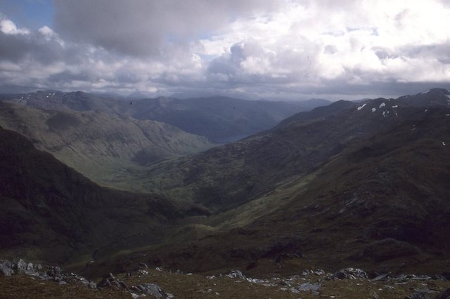
Aird Chadhachan is a hill located in Inverness-shire, Scotland. It is situated near the village of Tomatin and rises to an elevation of 570 meters (1,870 feet). The hill is part of the Monadhliath Mountains, which are known for their rugged terrain and stunning views.

Aird Chadhachan is a popular destination for hikers and outdoor enthusiasts looking to explore the wild beauty of the Scottish Highlands. The hill offers a challenging climb, with steep inclines and rocky outcrops along the way. However, the effort is rewarded with panoramic views of the surrounding countryside, including the River Findhorn and the Cairngorms National Park in the distance.

The area around Aird Chadhachan is rich in wildlife, with red deer, mountain hares, and various bird species often spotted in the area. The hill is also home to a variety of plant species, including heather, bilberry, and juniper.

Overall, Aird Chadhachan is a picturesque and rugged hill that provides a true taste of the Scottish wilderness for those willing to make the trek to its summit.

If you have any feedback on the listing, please let us know in the comments section below.

Aird Chadhachan Images

Images are sourced within 2km of 57.06112/-5.4553446 or Grid Reference NG9001. Thanks to Geograph Open Source API. All images are credited.

Sgurr a' Choire-bheithe Looking west from the summit of Aird Chadhachan (474m). Sgurr a' Choire-bheithe falls short of Munro height by just a metre! Michael took this photo during a 15-hour walk through the Rough Bounds of Knoydart.
Sgurr a' Choire-bheithe
Looking west from the summit of Aird Chadhachan (474m). Sgurr a' Choire-bheithe falls short of Munro height by just a metre! Michael took this photo during a 15-hour walk through the Rough Bounds of Knoydart.
East ridge, Sgùrr a' Choice Bheithe Looking out towards Loch Cuaich.  It's settled now, but this hill used to be subject to regular scares where a rumour went out that it was over 3000' and it enjoyed sudden bursts of popularity.  Hamish Brown once said it was "too fine a hill to be thrown to the dogs."
East ridge, Sgùrr a' Choice Bheithe
Looking out towards Loch Cuaich. It's settled now, but this hill used to be subject to regular scares where a rumour went out that it was over 3000' and it enjoyed sudden bursts of popularity. Hamish Brown once said it was "too fine a hill to be thrown to the dogs."
Glen Barrisdale View through Glen Barrisdale from Sgùrr a' Choire Bheithe
Glen Barrisdale
View through Glen Barrisdale from Sgùrr a' Choire Bheithe
South side of Sgùrr a' Choire Bheithe Sgùrr a' Choire Bheithe is typical of the Rough Bounds, being an east west long ridge with very steep sides with deep glens on either side. The landforms are due to erosion from glaciers falling off a central icecap. Often the slopes have failed, without the scaffolding of ice, they have slumped in huge landslides with fissures, mounds etc.  A good example is the chaos in Glen Pean.   Sgùrr a' Choire Bheithe used to be subject to munro scares, when rumours spread that it was resurveyed over 3000' and it experienced periods of popularity.  The issue is now settled.

I set off a similar phenomenon once on Glen Spean's Beinn Teallach.  That time it was true and even in those days before the consumer internet (1984) it was not long before a lot more cars were seen at the foot of the hill. I was also asked by the station master at Tulloch as to what was going on on the hill.  A really exciting time.  Now most height issues are settled, enthusiasts are listing hills including shale bings and arguing over 30m drop hills in England.  I feel I lived in the golden age of hill bagging.

The rather good view includes the steep north side of Beinn Aden and Lochan nam Breac.
South side of Sgùrr a' Choire Bheithe
Sgùrr a' Choire Bheithe is typical of the Rough Bounds, being an east west long ridge with very steep sides with deep glens on either side. The landforms are due to erosion from glaciers falling off a central icecap. Often the slopes have failed, without the scaffolding of ice, they have slumped in huge landslides with fissures, mounds etc. A good example is the chaos in Glen Pean. Sgùrr a' Choire Bheithe used to be subject to munro scares, when rumours spread that it was resurveyed over 3000' and it experienced periods of popularity. The issue is now settled. I set off a similar phenomenon once on Glen Spean's Beinn Teallach. That time it was true and even in those days before the consumer internet (1984) it was not long before a lot more cars were seen at the foot of the hill. I was also asked by the station master at Tulloch as to what was going on on the hill. A really exciting time. Now most height issues are settled, enthusiasts are listing hills including shale bings and arguing over 30m drop hills in England. I feel I lived in the golden age of hill bagging. The rather good view includes the steep north side of Beinn Aden and Lochan nam Breac.
West top, Sgùrr a' Choire Bheithe West of the summit with a view towards Ladhar Bheinn
West top, Sgùrr a' Choire Bheithe
West of the summit with a view towards Ladhar Bheinn
Sgùrr a' Choire Bheithe Sgùrr a' Choire Bheithe is typical of the Rough Bounds, being an east west long ridge with very steep sides with deep glens on either side. The landforms are due to erosion from glaciers falling off a central icecap. Often the slopes have failed, without the scaffolding of ice, they have slumped in huge landslides with fissures, mounds etc.  A good example is the chaos in Glen Pean.   Sgùrr a' Choire Bheithe used to be subject to munro scares, when rumours spread that it was resurveyed over 3000' and it experienced periods of popularity.  The issue is now settled.
Sgùrr a' Choire Bheithe
Sgùrr a' Choire Bheithe is typical of the Rough Bounds, being an east west long ridge with very steep sides with deep glens on either side. The landforms are due to erosion from glaciers falling off a central icecap. Often the slopes have failed, without the scaffolding of ice, they have slumped in huge landslides with fissures, mounds etc. A good example is the chaos in Glen Pean. Sgùrr a' Choire Bheithe used to be subject to munro scares, when rumours spread that it was resurveyed over 3000' and it experienced periods of popularity. The issue is now settled.
Coire Beithe Sgùrr a' Choire Bheithe seen from Barrisdale.
Coire Beithe
Sgùrr a' Choire Bheithe seen from Barrisdale.
Looking into Glen Barisdale From Sgùrr a' Choire Bheithe.
Looking into Glen Barisdale
From Sgùrr a' Choire Bheithe.
Dropping down to River Carnach
The Abhainn Chòsaidh This substantial burn drains the high corrie between Slat Bheinn and the Druim Chòsaidh, the ridge which runs eastwards from Sgurr a’ Choire-bhèithe. By all accounts, it can be an awkward one to cross in poor weather, especially further down in <a href="https://www.geograph.org.uk/gridref/NG9501">NG9501</a> where it approaches Loch Quoich; not a problem on this occasion, although it was carrying a bit of cold snow-melt water.
The hill in the background is the 841m Sgurr a' Chladeimh in <a href="https://www.geograph.org.uk/gridref/NG9503">NG9503</a>
The Abhainn Chòsaidh
This substantial burn drains the high corrie between Slat Bheinn and the Druim Chòsaidh, the ridge which runs eastwards from Sgurr a’ Choire-bhèithe. By all accounts, it can be an awkward one to cross in poor weather, especially further down in NG9501 where it approaches Loch Quoich; not a problem on this occasion, although it was carrying a bit of cold snow-melt water. The hill in the background is the 841m Sgurr a' Chladeimh in NG9503
The Abhainn Chòsaidh Seen here in the high corrie between Slat Bheinn and Druim Chòsaidh, the ridge east of Sgurr a’ Choire-bhèithe, this stream drains eastwards into Loch Quoich in <a href="https://www.geograph.org.uk/gridref/NG9601">NG9601</a>
The Abhainn Chòsaidh
Seen here in the high corrie between Slat Bheinn and Druim Chòsaidh, the ridge east of Sgurr a’ Choire-bhèithe, this stream drains eastwards into Loch Quoich in NG9601
The Allt Coire Slat Bheinn The burn drains a corrie below the hill Slat Bheinn, and also forms the outflow of Loch an Lagain Aintheich.
The Allt Coire Slat Bheinn
The burn drains a corrie below the hill Slat Bheinn, and also forms the outflow of Loch an Lagain Aintheich.
In the valley of the Abhainn Chòsaidh Down beside the substantial burn that drains the glen, with the ridge of Druim Chòsaidh forming the southern wall.
In the valley of the Abhainn Chòsaidh
Down beside the substantial burn that drains the glen, with the ridge of Druim Chòsaidh forming the southern wall.
The Abhainn Chòsaidh Running here through a deep part of the glen; that tree doesn't look long for this world.
The Abhainn Chòsaidh
Running here through a deep part of the glen; that tree doesn't look long for this world.
Waterfalls and steps on the Abhainn Chòsaidh A series of regular steps in the stream bed, almost looking man-made. They are, of course, entirely natural.
Waterfalls and steps on the Abhainn Chòsaidh
A series of regular steps in the stream bed, almost looking man-made. They are, of course, entirely natural.
Sidestream on the Abhainn Chòsaidh A small tributary from the hillside joins the main Abhainn Chòsaidh.
Sidestream on the Abhainn Chòsaidh
A small tributary from the hillside joins the main Abhainn Chòsaidh.
Tributary of the Abhainn Chòsaidh A small side-stream joins the main burn in the valley.
Tributary of the Abhainn Chòsaidh
A small side-stream joins the main burn in the valley.
Looking up the Abhainn Chòsaidh Along the length of the valley, with the ridge of Druim Chòsaidh on the skyline, and the Corbett of Sgurr a' Choire-bheithe at the far end.
Looking up the Abhainn Chòsaidh
Along the length of the valley, with the ridge of Druim Chòsaidh on the skyline, and the Corbett of Sgurr a' Choire-bheithe at the far end.
Show me another place!

Aird Chadhachan is located at Grid Ref: NG9001 (Lat: 57.06112, Lng: -5.4553446)

Unitary Authority: Highland

Police Authority: Highlands and Islands

What 3 Words

///blizzard.launcher.gears. Near Glenelg, Highland

Related Wikis

Sgùrr a' Choire-bheithe

Sgùrr a' Choire-bleithe is a 913-m mountain in the remote Knoydart area of Lochaber, Northwest Highlands, Scotland. It is one of highest Corbetts at 913...

Ben Aden

Ben Aden (887m) is a mountain in the Northwest Highlands of Scotland. It lies on the Knoydart peninsula in Lochaber. Regarded as one of the finest Corbetts...

Sgùrr nan Eugallt

Sgùrr nan Eugallt is the highest of a well defined group of mountains that lie south of Loch Hourn, stretching from Barrisdale to Loch Quoich. Although...

Luinne Bheinn

Luinne Bheinn (939 m) is a mountain in the Northwest Highlands of Scotland, on the Knoydart Peninsula in Lochaber. The mountain is rough and rocky. The...

Have you been to Aird Chadhachan?

Leave your review of Aird Chadhachan below (or comments, questions and feedback).