Cnoc an Tigh-fhraoich

Hill, Mountain in Argyllshire

Scotland

Cnoc an Tigh-fhraoich

View towards An Locha Cham (Cam Loch) I'm following a route vaguely suggested by some old waymarker posts.
View towards An Locha Cham (Cam Loch) Credit: Patrick Mackie

Cnoc an Tigh-fhraoich, also known as Tigh-fhraoich Hill, is a prominent hill located in Argyllshire, Scotland. It is situated in a remote and picturesque area, approximately 10 miles northeast of the town of Oban.

Standing at an elevation of 338 meters (1,109 feet), Cnoc an Tigh-fhraoich offers breathtaking views of the surrounding landscape. From its summit, on a clear day, visitors can enjoy panoramic vistas of the nearby Loch Etive, which stretches out towards the west coast of Scotland. The hill is also surrounded by rolling green hills, scattered woodlands, and a rich tapestry of heather and wildflowers.

Cnoc an Tigh-fhraoich is a popular destination for hikers and outdoor enthusiasts. There are several well-marked trails that lead to the summit, varying in difficulty to cater to different skill levels. The routes traverse through diverse terrain, including rocky paths, grassy slopes, and some muddy sections, requiring sturdy footwear and appropriate clothing.

The hill is known for its diverse wildlife, with the chance to spot various bird species, including buzzards and golden eagles, as well as red deer and other mammals. Nature lovers can also find an abundance of plant life, including heather, thistles, and wild orchids.

Due to its remote location, visitors are advised to bring provisions, such as food, water, and a map, as there are no facilities or services available on-site. It is also important to respect the natural environment by leaving no trace and following the Scottish Outdoor Access Code.

In summary, Cnoc an Tigh-fhraoich is a picturesque hill in Argyllshire, offering stunning views, diverse wildlife, and a range of hiking opportunities for outdoor enthusiasts.

If you have any feedback on the listing, please let us know in the comments section below.

Cnoc an Tigh-fhraoich Images

Images are sourced within 2km of 56.040114/-5.463891 or Grid Reference NR8488. Thanks to Geograph Open Source API. All images are credited.

View towards An Locha Cham (Cam Loch) I'm following a route vaguely suggested by some old waymarker posts.
View towards An Locha Cham (Cam Loch)
I'm following a route vaguely suggested by some old waymarker posts.
Waymarker post and forest ride A glimpse of Loch Fyne in the distance.
Waymarker post and forest ride
A glimpse of Loch Fyne in the distance.
Waymarker post and view towards Loch Fyne
Church, Lochgilphead
Lochgilphead, Council Offices
Flush Bracket OSBM G4125 - Lochgilphead, Council Offices
OS Published Abstract Bolt - Lochgilphead, #3 Colchester Square Building on Colchester Square, junc Argyll St & Lochnell St. Seems this was a Post Office when mark was cut, but now the Dalriada Home Hardware shop

<span class="nowrap"><a title="https://www.bench-marks.org.uk/bm58103" rel="nofollow ugc noopener" href="https://www.bench-marks.org.uk/bm58103">Link</a><img style="margin-left:2px;" alt="External link" title="External link - shift click to open in new window" src="https://s1.geograph.org.uk/img/external.png" width="10" height="10"/></span>
OS Published Abstract Bolt - Lochgilphead, #3 Colchester Square
Building on Colchester Square, junc Argyll St & Lochnell St. Seems this was a Post Office when mark was cut, but now the Dalriada Home Hardware shop LinkExternal link
Ghost sign The former Lloydspharmacy in the town has been sold to a new business and the previous branding has been removed. This has revealed a "ghost sign" from a former business - Donald Crawford's jewellers.
Ghost sign
The former Lloydspharmacy in the town has been sold to a new business and the previous branding has been removed. This has revealed a "ghost sign" from a former business - Donald Crawford's jewellers.
Front green improvements Following a £1.5M investment in the town's public space on the shores of Loch Gilp, the area opened to the public a few weeks ago. This image shows a feature wall, with maps, which separates the upgraded play area on the other side from a large paved public space.
More information about the project can be found on Argyll and Bute Council's website <span class="nowrap"><a title="https://www.argyll-bute.gov.uk/frontgreen" rel="nofollow ugc noopener" href="https://www.argyll-bute.gov.uk/frontgreen">Link</a><img style="margin-left:2px;" alt="External link" title="External link - shift click to open in new window" src="https://s1.geograph.org.uk/img/external.png" width="10" height="10"/></span>.
Front green improvements
Following a £1.5M investment in the town's public space on the shores of Loch Gilp, the area opened to the public a few weeks ago. This image shows a feature wall, with maps, which separates the upgraded play area on the other side from a large paved public space. More information about the project can be found on Argyll and Bute Council's website LinkExternal link.
Achnabreck Cemetery Achnabreck Cemetery is a large, walled burial site lying to the north of Lochgilphead.
Achnabreck Cemetery
Achnabreck Cemetery is a large, walled burial site lying to the north of Lochgilphead.
Argyll Street Argyll Street is the main commercial part of Lochgilphead.
The sea area in the distance is at the head of the sea loch, Loch Gilp... and so the town's name. The war memorial can be seen in outline against it.
Argyll Street
Argyll Street is the main commercial part of Lochgilphead. The sea area in the distance is at the head of the sea loch, Loch Gilp... and so the town's name. The war memorial can be seen in outline against it.
Crinan Canal passing Lochgilphead The canal heading north as it passes the small town where instead of being cut into the land as most canals are, it's retained against a rising slope by an embankment along which the tow path travels. (The grass to the right is not the path, that's a hard-surfaced way, mainly out of view in the image.)
Crinan Canal passing Lochgilphead
The canal heading north as it passes the small town where instead of being cut into the land as most canals are, it's retained against a rising slope by an embankment along which the tow path travels. (The grass to the right is not the path, that's a hard-surfaced way, mainly out of view in the image.)
Low-lying land with regenerating woodland beside Crinan Canal The rough moorland lies between the canal and the route of the A816 which has the Badden Burn alongside it, presumably with its course somewhat realigned. Near to the camera and mainly out of view to the right, there's regenerating woodland.
Low-lying land with regenerating woodland beside Crinan Canal
The rough moorland lies between the canal and the route of the A816 which has the Badden Burn alongside it, presumably with its course somewhat realigned. Near to the camera and mainly out of view to the right, there's regenerating woodland.
Crinan Canal heading north, approaching Lochgilphead The canal north of Ardrishaig passing an old, lozenge-shaped sign which warned, presumably, of a cable in the vicinity that needed avoiding. The western part of Lochgilphead lies just ahead.
Crinan Canal heading north, approaching Lochgilphead
The canal north of Ardrishaig passing an old, lozenge-shaped sign which warned, presumably, of a cable in the vicinity that needed avoiding. The western part of Lochgilphead lies just ahead.
War memorial in Lochgilphead The monument is at a focal point in the small town. The image shows its rear with commercial buildings across the A83 at the corner of Argyll Street and Lochnell Street.
War memorial in Lochgilphead
The monument is at a focal point in the small town. The image shows its rear with commercial buildings across the A83 at the corner of Argyll Street and Lochnell Street.
Grassed areas with The Hollies beyond The buildings face out over the grassed area towards the head of Loch Gilp which gives Lochgilphead its name. The Hollies is a fine, stone-built detached house across the A83 which here is named Poltalloch Street
Grassed areas with The Hollies beyond
The buildings face out over the grassed area towards the head of Loch Gilp which gives Lochgilphead its name. The Hollies is a fine, stone-built detached house across the A83 which here is named Poltalloch Street
St. Margaret's Church St. Margaret's is the Roman Catholic Church in Lochgilphead; it's at the junction of Argyll Street and Manse Brae. The building to the right is the priest's house.
St. Margaret's Church
St. Margaret's is the Roman Catholic Church in Lochgilphead; it's at the junction of Argyll Street and Manse Brae. The building to the right is the priest's house.
Argyll Tyres, Lochgilphead Dutch barn style garage
Argyll Tyres, Lochgilphead
Dutch barn style garage
Show me another place!

Cnoc an Tigh-fhraoich is located at Grid Ref: NR8488 (Lat: 56.040114, Lng: -5.463891)

Unitary Authority: Argyll and Bute

Police Authority: Argyll and West Dunbartonshire

What 3 Words

///endlessly.prowl.after. Near Lochgilphead, Argyll & Bute

Nearby Locations

Cnoc an Tigh-fhraoich

Related Wikis

Lochgilphead

Lochgilphead (; Scottish Gaelic: Ceann Loch Gilb [kʲʰan̪ˠ l̪ˠɔx ˈkʲilip]) is a town and former burgh in Argyll and Bute, Scotland, with a population of...
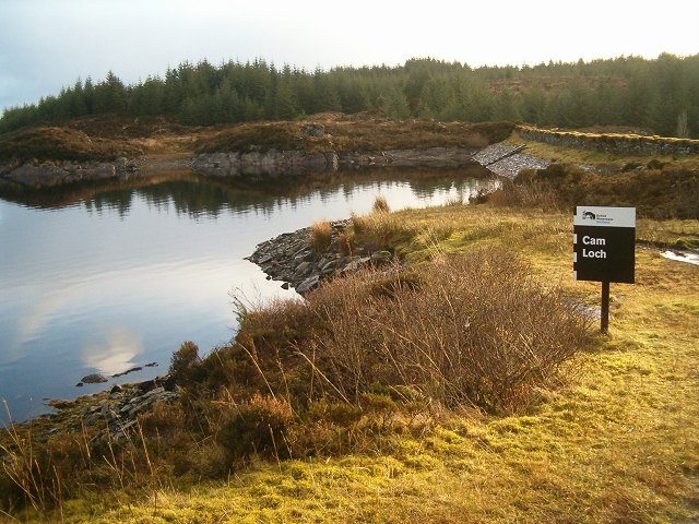
Cam Loch

Cam Loch (the Crooked Loch) is one of a number of water supply sources for the Crinan Canal. The impounding reservoir lies to the south of the canal and...
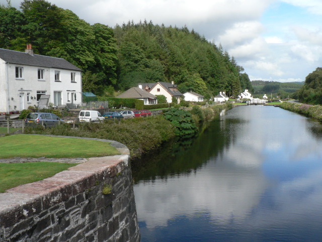
Crinan Canal

The Crinan Canal between Crinan and Ardrishaig in Argyll and Bute in the west of Scotland is operated by Scottish Canals. The canal, which opened in 1801...

Glengilp distillery

Glengilp distillery (also known as Glenfyne distillery and Glendarroch distillery) was a whisky distillery located, from 1831 to 1937, on the banks of...

Nearby Amenities

Located within 500m of 56.040114,-5.463891
Power: tower
Source: Bing
Lat/Long: 56.0395657/-5.4561457
Power: tower
Lat/Long: 56.0440794/-5.4674615
Power: tower
Lat/Long: 56.0416442/-5.4699814
The data included in this document is from www.openstreetmap.org. The data is made available under ODbL.

Have you been to Cnoc an Tigh-fhraoich?

Leave your review of Cnoc an Tigh-fhraoich below (or comments, questions and feedback).