Ard Hill

Hill, Mountain in Ross-shire

Scotland

Ard Hill

A87 at Kirkton
A87 at Kirkton Credit: Steven Brown

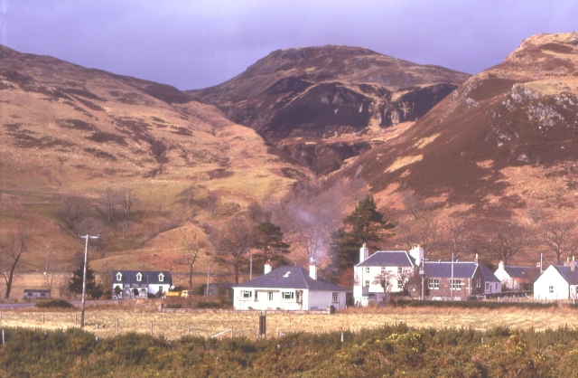
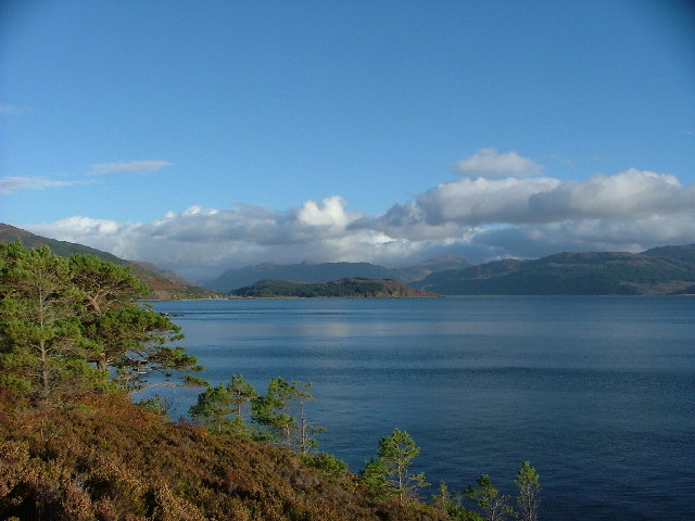
Ard Hill is a prominent hill located in the county of Ross-shire, in the Scottish Highlands. It stands at an elevation of approximately 1,155 feet (352 meters) above sea level, making it a notable landmark in the region. Situated near the village of Ardross, Ard Hill offers breathtaking panoramic views of the surrounding countryside, including the picturesque Cromarty Firth and the rugged hills of Easter Ross.

The hill is characterized by its gently sloping terrain, covered in a patchwork of heather, grasses, and scattered trees. Its relatively easy ascent makes it a popular destination for hikers and nature enthusiasts, offering a rewarding outdoor experience. The summit of Ard Hill provides a commanding vantage point, allowing visitors to admire the stunning natural beauty of the Scottish Highlands.

The area surrounding Ard Hill is rich in wildlife, with numerous species of birds, mammals, and plant life to be found. On a clear day, it is not uncommon to spot red deer, hares, and various bird species, including golden eagles and red kites, soaring through the sky.

Ard Hill is easily accessible, with a network of footpaths and trails leading to its summit. It is an ideal location for a leisurely walk or a more challenging hike, catering to all levels of fitness and experience. Whether it's for the breathtaking views, the chance to immerse oneself in nature, or simply to enjoy a peaceful day out, Ard Hill offers a memorable experience for visitors to Ross-shire.

If you have any feedback on the listing, please let us know in the comments section below.

Ard Hill Images

Images are sourced within 2km of 57.277694/-5.6155372 or Grid Reference NG8226. Thanks to Geograph Open Source API. All images are credited.

A87 at Kirkton
A87 at Kirkton
Lichens on Old Oak In amongst the small pocket of Atlantic Oakwoods above Reraig and this old dead oak has an array of lichens - probably Beard or Horsehair Lichen - growing on it.
A lovely walk to do on a wet summer's day. Some information here:-
<span class="nowrap"><a title="https://forestryandland.gov.scot/visit/balmacara-woods" rel="nofollow ugc noopener" href="https://forestryandland.gov.scot/visit/balmacara-woods">Link</a><img style="margin-left:2px;" alt="External link" title="External link - shift click to open in new window" src="https://s1.geograph.org.uk/img/external.png" width="10" height="10"/></span>
Lichens on Old Oak
In amongst the small pocket of Atlantic Oakwoods above Reraig and this old dead oak has an array of lichens - probably Beard or Horsehair Lichen - growing on it. A lovely walk to do on a wet summer's day. Some information here:- LinkExternal link
Mighty Larch Trunks These big mature Larch Trees are at the bottom of one of the woodland walks above Reraig and Balmacara. You can see evidence of the damage from last winter's storms.
Mighty Larch Trunks
These big mature Larch Trees are at the bottom of one of the woodland walks above Reraig and Balmacara. You can see evidence of the damage from last winter's storms.
Before the 'Throw-Up' Kinlochshiel and Glengarry 2nd teams just before the 'Throw-Up' to start a North Division 1 shinty match at Reraig in the west highlands. An improvised shelter for spectators made from old shipping containers can be seen behind the teams.
Kinlochshiel - in red - went on to win narrowly 3-2. I left after the first goal as I was getting eaten alive by midges and it had started raining. The things you do to pass the time on a wet summer's day in the Scottish Highlands!
Before the 'Throw-Up'
Kinlochshiel and Glengarry 2nd teams just before the 'Throw-Up' to start a North Division 1 shinty match at Reraig in the west highlands. An improvised shelter for spectators made from old shipping containers can be seen behind the teams. Kinlochshiel - in red - went on to win narrowly 3-2. I left after the first goal as I was getting eaten alive by midges and it had started raining. The things you do to pass the time on a wet summer's day in the Scottish Highlands!
A87 at Reraig
A87 at Reraig
A Traffic Queue near to Balmacara Roadworks on the A87 have caused a build-up of traffic heading towards Kyle of Lochalsh and the Isle of Skye.
A Traffic Queue near to Balmacara
Roadworks on the A87 have caused a build-up of traffic heading towards Kyle of Lochalsh and the Isle of Skye.
Reraig, A87
Reraig, A87
Eastbound A87 near Kirkton The A87 is a primary route  in the Highland region of Scotland. It runs west for 99 miles from its junction with the A82 at Invergarry, along the north shores of Loch Garry and Loch Cluanie, then through Glen Shiel and along Loch Duich to Kyle of Lochalsh before crossing the Skye Bridge to Kyleakin, Broadford, and Portree, before terminating at Uig in the north of the Isle of Skye.
Eastbound A87 near Kirkton
The A87 is a primary route in the Highland region of Scotland. It runs west for 99 miles from its junction with the A82 at Invergarry, along the north shores of Loch Garry and Loch Cluanie, then through Glen Shiel and along Loch Duich to Kyle of Lochalsh before crossing the Skye Bridge to Kyleakin, Broadford, and Portree, before terminating at Uig in the north of the Isle of Skye.
A87 at Kirkton The A87 is a primary route  in the Highland region of Scotland. It runs west for 99 miles from its junction with the A82 at Invergarry, along the north shores of Loch Garry and Loch Cluanie, then through Glen Shiel and along Loch Duich to Kyle of Lochalsh before crossing the Skye Bridge to Kyleakin, Broadford, and Portree, before terminating at Uig in the north of the Isle of Skye.
A87 at Kirkton
The A87 is a primary route in the Highland region of Scotland. It runs west for 99 miles from its junction with the A82 at Invergarry, along the north shores of Loch Garry and Loch Cluanie, then through Glen Shiel and along Loch Duich to Kyle of Lochalsh before crossing the Skye Bridge to Kyleakin, Broadford, and Portree, before terminating at Uig in the north of the Isle of Skye.
A87 near Reraig
A87 near Reraig
A87 at Reraig
A87 at Reraig
Reservoir (disused) Believed to be the reservoir that supplied the WWII gun emplacement/camp above Reraig in the area of the view point shown on the OS map (NG810276).
When the "Red Trail" was constructed it was filled in by the Forestry Commission.
Reservoir (disused)
Believed to be the reservoir that supplied the WWII gun emplacement/camp above Reraig in the area of the view point shown on the OS map (NG810276). When the "Red Trail" was constructed it was filled in by the Forestry Commission.
Village of Reraig Reraig, on the shore of Lochalsh, in centre of picture.  The Isle of Skye and the Sound of Sleat beyond
Village of Reraig
Reraig, on the shore of Lochalsh, in centre of picture. The Isle of Skye and the Sound of Sleat beyond
Westward on Loch Alsh at Balmacara, to Skye On A87, by the Donald Merchison Monument, about two miles from the Kyle of Lochalsh, showing the piers already erected of the Skye Bridge at Kyleakin, which was opened on 16/10/95.
Westward on Loch Alsh at Balmacara, to Skye
On A87, by the Donald Merchison Monument, about two miles from the Kyle of Lochalsh, showing the piers already erected of the Skye Bridge at Kyleakin, which was opened on 16/10/95.
Dun NW of Kirkton, Lochalsh "A kind of hill fort and also a kind of Atlantic roundhouse."
In this case all that remains are a moss covered circle of stones.
See also <span class="nowrap"><a title="http://canmore.org.uk/site/11859/kirkton" rel="nofollow ugc noopener" href="http://canmore.org.uk/site/11859/kirkton">Link</a><img style="margin-left:2px;" alt="External link" title="External link - shift click to open in new window" src="https://s1.geograph.org.uk/img/external.png" width="10" height="10"/></span>
Dun NW of Kirkton, Lochalsh
"A kind of hill fort and also a kind of Atlantic roundhouse." In this case all that remains are a moss covered circle of stones. See also LinkExternal link
Footpath - the Red Trail Part of the Forestry Commission walks network starting from Balmacara Square.
This is the steep(-er than it looks) section in the oak wood above the path between Reraig and Kirkton.
Footpath - the Red Trail
Part of the Forestry Commission walks network starting from Balmacara Square. This is the steep(-er than it looks) section in the oak wood above the path between Reraig and Kirkton.
Shop and hotel at Reraig The tide is out on Loch Alsh to the right.
Shop and hotel at Reraig
The tide is out on Loch Alsh to the right.
Headland at Ard Hill Taken from the shore at low tide the headland at Ard Hill Balmacara.
Headland at Ard Hill
Taken from the shore at low tide the headland at Ard Hill Balmacara.
Show me another place!

Ard Hill is located at Grid Ref: NG8226 (Lat: 57.277694, Lng: -5.6155372)

Unitary Authority: Highland

Police Authority: Highlands and Islands

What 3 Words

///generally.staples.deprives. Near Kyleakin, Highland

Nearby Locations

Ard Hill

Related Wikis

Balmacara Square

Balmacara Square (Scottish Gaelic: Ceàrnag Bhaile Mac Carra) is a small village, close to Balmacara, in Lochlash, Scottish Highlands and is in the council...

Balmacara

Balmacara (Scottish Gaelic: Baile Mac Ara) is a scattered village on the north shore of Loch Alsh near Kyle of Lochalsh, Ross-shire, Highland and is in...

Auchtertyre

Auchtertyre (Scottish Gaelic: Uachdar Thìre, "Upper Land") is a village, lying half a mile from the north shore of Loch Alsh near Kyle of Lochalsh, in...

Balmacara Bay

Balmacara Bay is a remote wide mouthed embayment on a 193° orientation, located on the north shore of the Lochalsh peninsula, on the north coast of sea...

Nearby Amenities

Located within 500m of 57.277694,-5.6155372
Created By: almien_coastlines
Source: PGS
Lat/Long: 57.277506/-5.623667
Created By: almien_coastlines
Source: PGS
Lat/Long: 57.276748/-5.62314
Created By: almien_coastlines
Source: PGS
Lat/Long: 57.275986/-5.622848
Created By: almien_coastlines
Source: PGS
Lat/Long: 57.276015/-5.621432
Created By: almien_coastlines
Source: PGS
Lat/Long: 57.275755/-5.621651
Created By: almien_coastlines
Source: PGS
Lat/Long: 57.275243/-5.621614
Created By: almien_coastlines
Source: PGS
Lat/Long: 57.27512/-5.621368
Created By: almien_coastlines
Source: PGS
Lat/Long: 57.27513/-5.620896
Created By: almien_coastlines
Source: PGS
Lat/Long: 57.275268/-5.620433
Created By: almien_coastlines
Source: PGS
Lat/Long: 57.274506/-5.620143
Created By: almien_coastlines
Source: PGS
Lat/Long: 57.274382/-5.619897
Created By: almien_coastlines
Source: PGS
Lat/Long: 57.274421/-5.618009
Created By: almien_coastlines
Source: PGS
Lat/Long: 57.274555/-5.617783
Created By: almien_coastlines
Source: PGS
Lat/Long: 57.274687/-5.617555
Created By: almien_coastlines
Source: PGS
Lat/Long: 57.274697/-5.617082
Created By: almien_coastlines
Source: PGS
Lat/Long: 57.274707/-5.61661
Created By: almien_coastlines
Source: PGS
Lat/Long: 57.27484/-5.616384
Created By: almien_coastlines
Source: PGS
Lat/Long: 57.274972/-5.616156
Created By: almien_coastlines
Source: PGS
Lat/Long: 57.275258/-5.614758
Created By: almien_coastlines
Source: PGS
Lat/Long: 57.275553/-5.612887
Created By: almien_coastlines
Source: PGS
Lat/Long: 57.275838/-5.611489
Created By: almien_coastlines
Source: PGS
Lat/Long: 57.275971/-5.611263
Created By: almien_coastlines
Source: PGS
Lat/Long: 57.276103/-5.611035
Created By: almien_coastlines
Source: PGS
Lat/Long: 57.276379/-5.610109
Created By: almien_coastlines
Source: PGS
Lat/Long: 57.276654/-5.609183
Created By: almien_coastlines
Source: PGS
Lat/Long: 57.276787/-5.608956
Created By: almien_coastlines
Source: PGS
Lat/Long: 57.27692/-5.608728
Created By: almien_coastlines
Source: PGS
Lat/Long: 57.277053/-5.608502
Created By: almien_coastlines
Source: PGS
Lat/Long: 57.277185/-5.608274
Ard Hill
Ele: 82
Natural: peak
Lat/Long: 57.2775924/-5.6157961
Power: pole
Lat/Long: 57.2817485/-5.6150286
The data included in this document is from www.openstreetmap.org. The data is made available under ODbL.

Have you been to Ard Hill?

Leave your review of Ard Hill below (or comments, questions and feedback).