An Creachan
Hill, Mountain in Argyllshire
Scotland
An Creachan

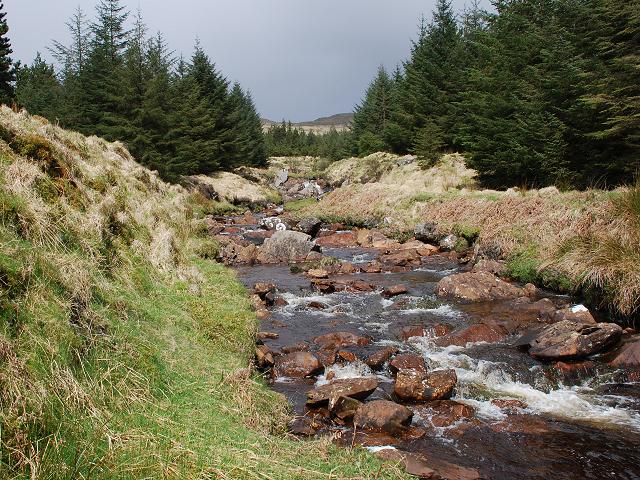
An Creachan is a prominent hill located in Argyllshire, Scotland. Standing at an impressive height of 857 meters (2812 feet), it offers breathtaking views of the surrounding landscape. The hill is part of the Creachan ridge, which stretches for several kilometers, providing hikers and mountaineers with a challenging and rewarding experience.
An Creachan is known for its rugged terrain and steep slopes, making it a popular destination for outdoor enthusiasts seeking adventure. Its rocky and boulder-strewn slopes add to the excitement and sense of accomplishment upon reaching the summit. The hill is composed mainly of granite and offers a unique geological experience for those interested in studying the region's natural history.
The ascent to the top of An Creachan can be demanding, but the panoramic views from the summit make every step worthwhile. On a clear day, visitors can admire the vast expanse of Loch Awe, one of Scotland's largest freshwater lochs, as well as the surrounding peaks and valleys. The hill is also home to a variety of plant and animal species, including heather, mosses, and birds of prey, adding to its natural beauty and ecological significance.
An Creachan is accessible via various trails, with the most popular route starting from the nearby village of Dalmally. This makes it a suitable destination for both experienced climbers and those looking for a leisurely hike. However, it is important to come prepared with appropriate gear, as weather conditions can change rapidly and the terrain can be challenging. Overall, An Creachan offers an unforgettable mountain experience in the stunning landscape of Argyllshire.
If you have any feedback on the listing, please let us know in the comments section below.
An Creachan Images
Images are sourced within 2km of 55.876616/-5.4848397 or Grid Reference NR8270. Thanks to Geograph Open Source API. All images are credited.


An Creachan is located at Grid Ref: NR8270 (Lat: 55.876616, Lng: -5.4848397)
Unitary Authority: Argyll and Bute
Police Authority: Argyll and West Dunbartonshire
What 3 Words
///scramble.pricing.seagulls. Near Tarbert, Argyll & Bute
Nearby Locations
Related Wikis
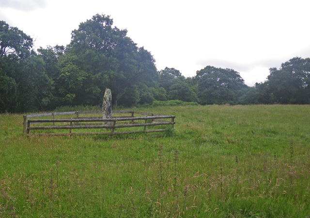
Avinagillan standing stone
The Avinagillan standing stone is a prehistoric menhir on the Kintyre Peninsula of Scotland. The stone is near the hamlet of Avinagillan. == See also... ==
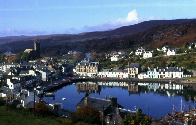
Tarbert, Kintyre
Tarbert (Scottish Gaelic: An Tairbeart, pronounced [ən̪ˠ ˈt̪ʰaɾʲapərˠʃt̪], or Tairbeart Loch Fìne to distinguish it from other places of the same name...

Stonefield Castle
Stonefield Castle is a Scottish baronial manor house near the village of Stonefield, north of Tarbert, Argyll & Bute, Scotland. It was built on the site...

Tarbert Castle
Tarbert Castle is located on the southern shore of East Loch Tarbert, at Tarbert, Argyll, Scotland, at the north end of Kintyre. Tarbert Castle was a strategic...

Barmore Island
Barmore Island is a peninsula in Scotland located on the east of Knapdale, in the council area of Argyll and Bute. It is 1 and a half miles north from...

East Loch Tarbert, Argyll
East Loch Tarbert, Argyll is a small sea loch on the eastern side of the Kintyre peninsula in Scotland. It is a part of the much larger Loch Fyne. The...

Torinturk
Torinturk (Scottish Gaelic: Tòrr an Tuirc) is a village in Argyll and Bute, Scotland. Torinturk is 5 miles (8 km) from Tarbert. Torinturk comes from the...

Dùn a' Choin Duibh
Dùn a' Choin Duibh (Scottish Gaelic: Fort of the Black Dog) is a hillfort located near Torinturk, Argyll and Bute, Scotland. According to the local shanachies...
Nearby Amenities
Located within 500m of 55.876616,-5.4848397Have you been to An Creachan?
Leave your review of An Creachan below (or comments, questions and feedback).