Druim na h-Iùbhraich
Hill, Mountain in Argyllshire
Scotland
Druim na h-Iùbhraich

Druim na h-Iùbhraich is a prominent hill located in Argyllshire, Scotland. It is situated near the village of Taynuilt, approximately 12 miles east of Oban. With a height of 416 meters (1,365 feet), it offers stunning panoramic views of the surrounding countryside and Loch Etive.
The hill is a popular destination for hikers and nature enthusiasts, attracting visitors from both near and far. The ascent to the summit is relatively moderate, making it accessible to people of various fitness levels. Along the way, walkers are treated to a diverse range of flora and fauna, including heather, mosses, and various species of birds.
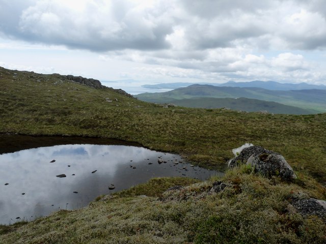
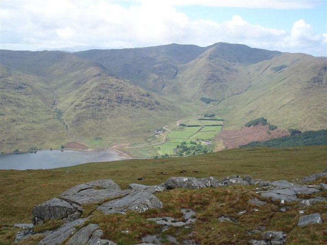
At the top of Druim na h-Iùbhraich, the reward is a breathtaking vista that encompasses the stunning landscapes of Argyllshire. On a clear day, one can see the rugged peaks of the surrounding hills, the shimmering waters of Loch Etive, and the picturesque village of Taynuilt below.
The hill also holds historical significance, with remnants of ancient settlements and cairns dotting its slopes. These archaeological features provide a glimpse into the area's rich past and offer an opportunity for exploration and discovery.
For those seeking outdoor activities, Druim na h-Iùbhraich offers various walking and hiking routes, including a circular path that allows visitors to fully experience the beauty of the hill and its surroundings. Whether it's for a leisurely stroll or a more challenging hike, Druim na h-Iùbhraich is a must-visit destination for nature lovers and history enthusiasts alike.
If you have any feedback on the listing, please let us know in the comments section below.
Druim na h-Iùbhraich Images
Images are sourced within 2km of 56.579039/-5.5872407 or Grid Reference NM7948. Thanks to Geograph Open Source API. All images are credited.


Druim na h-Iùbhraich is located at Grid Ref: NM7948 (Lat: 56.579039, Lng: -5.5872407)
Unitary Authority: Highland
Police Authority: Highlands and Islands
What 3 Words
///help.sticking.demanding. Near Lochaline, Highland
Nearby Locations
Related Wikis
Beinn Mheadhoin (Morvern)
Beinn Mheadhoin (739 m) is a mountain in the Northwest Highlands of Scotland. It is located in the Morvern area of Lochaber. A peak of various ridges with...
Glensanda
Glensanda (Old Norse, the glen of the sandy river) was a Viking settlement at the mouth of Glen Sanda on the Morvern peninsula within south west Lochaber...

Morvern
Morvern (Scottish Gaelic: A' Mhorbhairne [ə ˈvɔɾɔ.əɾɲə]; "the sea-gap"), historically also spelt Morven, is a peninsula and traditional district in the...

Castle Coeffin
Castle Coeffin is a ruin on the island of Lismore, an island in Loch Linnhe, in Argyll, on the west coast of Scotland. It stands on a promontory on the...

St Moluag's Cathedral, Lismore
St Moluag's Cathedral is located on the Scottish island of Lismore just off the coast of Oban. As a congregation of the Church of Scotland, which is Presbyterian...

Lismore, Scotland
Lismore (Scottish Gaelic: Lios Mòr, pronounced [ʎis̪ ˈmoːɾ] possibly meaning "great enclosure" or "garden") is an island of some 2,351 hectares (9.1 square...

Tirefour Castle
Tirefour Castle, (or Tirefour Broch, also spelled Tirfuir and Tirrefour) is an Iron Age broch located 4 kilometres north of Achnacroish on the island of...

Bernera Island
Bernera Island (Scottish Gaelic: Beàrnaraigh) or simply Bernera is a tidal island off Lismore, in Argyll, Scotland. == History == In the 6th century, Bernera...
Have you been to Druim na h-Iùbhraich?
Leave your review of Druim na h-Iùbhraich below (or comments, questions and feedback).