An t-Slat-Bheinn

Hill, Mountain in Inverness-shire

Scotland

An t-Slat-Bheinn

Sgùrr na Bà Glaise One of the higher Moidart hills seen from beside the A830.
Sgùrr na Bà Glaise Credit: Richard Webb

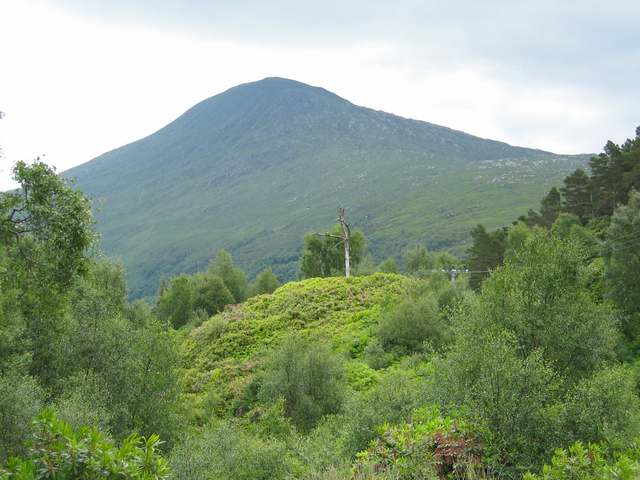
An t-Slat-Bheinn is a prominent hill located in Inverness-shire, Scotland. It is part of the Monadhliath Mountains range and stands at an elevation of 870 meters (2,854 feet) above sea level. The hill is known for its rugged and rocky terrain, making it a popular destination for hikers and outdoor enthusiasts looking for a challenging climb.

The name An t-Slat-Bheinn translates to "the hill of the ridge" in Gaelic, which is fitting given its distinctive ridge-like shape. The hill offers stunning panoramic views of the surrounding countryside, including the Cairngorms National Park and the River Findhorn.

The terrain of An t-Slat-Bheinn is characterized by heather-covered slopes, rocky outcrops, and steep ascents, making it a demanding climb for even experienced hikers. The hill is accessible via various routes, with the most popular starting point being the village of Tomatin.

Overall, An t-Slat-Bheinn is a challenging yet rewarding climb for those looking to experience the natural beauty and rugged landscape of the Scottish Highlands.

If you have any feedback on the listing, please let us know in the comments section below.

An t-Slat-Bheinn Images

Images are sourced within 2km of 56.838428/-5.6434048 or Grid Reference NM7777. Thanks to Geograph Open Source API. All images are credited.

Sgùrr na Bà Glaise One of the higher Moidart hills seen from beside the A830.
Sgùrr na Bà Glaise
One of the higher Moidart hills seen from beside the A830.
Bealach an Fhalaisg Dhuibh
Druim Fiaclach Ridge Druim Fiaclach Ridge and Coire Rèidh.
Druim Fiaclach Ridge
Druim Fiaclach Ridge and Coire Rèidh.
Bealach an Fhiona
Bealach an Fhiona
Coire a' Bhuiridh
Coire a' Bhuiridh
Allt a' Bhuiridh
Allt a' Bhuiridh
Bealach an Fiona This high pass was once used as a kirk road, ie  a  funeral route to a burial place.  The view is down Glen Moidart on the southern end of the pass.
Bealach an Fiona
This high pass was once used as a kirk road, ie a funeral route to a burial place. The view is down Glen Moidart on the southern end of the pass.
Brocken Spectre Familiar and common sight for hillgoers, a shadow cast upon cloud with refraction fringes forming a "glory". Looking into Coire a'Bhuiridh.
Brocken Spectre
Familiar and common sight for hillgoers, a shadow cast upon cloud with refraction fringes forming a "glory". Looking into Coire a'Bhuiridh.
Camping in Coire a Bhuiridh
Upper Coire a Bhuiridh
Looking west over Coire na Cnamha to the sea
The rocky north face at Bealach an Fhiona
An Stac from Bealach an Fhiona
Rois-bheinn from Bealach an Fhiona
Sgurr na ba Glaise from Bealach an Fhiona
Allt a Bhuiridh flowing north
Bealach na Lice This narrowing of the glen is where Glen Moidart (below) swings to the east and climbs into the secret Glen Gluitanen (behind the photographer). Care has to be taken in descending through the gorge.
Bealach na Lice
This narrowing of the glen is where Glen Moidart (below) swings to the east and climbs into the secret Glen Gluitanen (behind the photographer). Care has to be taken in descending through the gorge.
Upper reaches of River Moidart The River Moidart winds through a flat part of the glen here, where there are ruins of old settlements. The river comes through the Bealach na Lice which is the narrow slit in the crags in the centre of the photo.
Upper reaches of River Moidart
The River Moidart winds through a flat part of the glen here, where there are ruins of old settlements. The river comes through the Bealach na Lice which is the narrow slit in the crags in the centre of the photo.
Show me another place!

An t-Slat-Bheinn is located at Grid Ref: NM7777 (Lat: 56.838428, Lng: -5.6434048)

Unitary Authority: Highland

Police Authority: Highlands and Islands

What 3 Words

///bill.refusals.jeering. Near Arisaig, Highland

Related Wikis

Rois-bheinn

Rois-bheinn is the joint highest hill in the Scottish region of Moidart, a title it shares with its neighbour Beinn Odhar Bheag, whose summit has the same...

An Stac

An Stac is the name of a 814 m mountain in the Northwest Highlands, Scotland, on the shore of Loch Ailort on the west coast of Lochaber. A steep-sided...

Alisary

Alisary is a tiny settlement in Highland, Scotland.

Moidart

Moidart ( MOY-dart; Scottish Gaelic: Mùideart [ˈmuːitʲarˠʃt̪]) is part of the remote and isolated area of Scotland, west of Fort William, known as the...

Nearby Amenities

Located within 500m of 56.838428,-5.6434048
An t-Slat-Bheinn
Natural: peak
Source: os_openmap_local
Lat/Long: 56.8383277/-5.640707
The data included in this document is from www.openstreetmap.org. The data is made available under ODbL.

Have you been to An t-Slat-Bheinn?

Leave your review of An t-Slat-Bheinn below (or comments, questions and feedback).