An Garbh-Mheall

Hill, Mountain in Ross-shire

Scotland

An Garbh-Mheall

Deer fence This deer fence is part of the North Applecross Woodland Project.

In the background can be seen the northern tip of Rona with its lighthouse: <a href="https://www.geograph.org.uk/photo/538456">NG6361 : Lighthouse on Rona</a>.
Deer fence Credit: Toby Speight

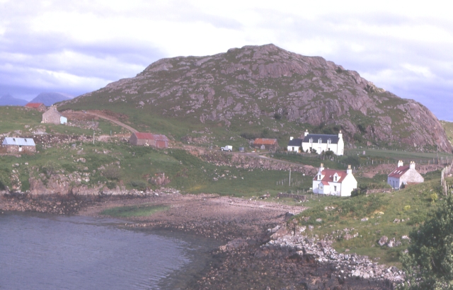
An Garbh-Mheall is a prominent hill located in the county of Ross-shire, in the Scottish Highlands. It stands at an elevation of approximately 931 meters (3,054 feet) and is part of the Beinn Dearg mountain range. The hill is situated about 10 kilometers (6 miles) southeast of the town of Ullapool.

An Garbh-Mheall is characterized by its rugged and rocky terrain, typical of the Scottish Highlands. It offers breathtaking panoramic views of the surrounding landscape, including nearby mountains, lochs, and valleys. The hill is known for its challenging and steep ascent, making it a popular destination for experienced hikers and mountaineers seeking a thrilling adventure.

The vegetation on An Garbh-Mheall consists mostly of heather and grasses, with scattered patches of woodland in the lower slopes. The hill is also home to a variety of wildlife, including deer, mountain hares, and a diverse range of bird species.

The hill is easily accessible from Ullapool, with several hiking trails leading to its summit. These trails vary in difficulty, catering to both experienced climbers and beginners. However, it is important for visitors to be well-prepared and equipped with appropriate clothing and supplies, as the weather conditions on An Garbh-Mheall can be unpredictable and harsh, especially during winter months.

Overall, An Garbh-Mheall is a stunning and challenging hill that attracts outdoor enthusiasts seeking a rewarding and adventurous experience in the picturesque Scottish Highlands.

If you have any feedback on the listing, please let us know in the comments section below.

An Garbh-Mheall Images

Images are sourced within 2km of 57.509187/-5.7975766 or Grid Reference NG7252. Thanks to Geograph Open Source API. All images are credited.

Deer fence This deer fence is part of the North Applecross Woodland Project.

In the background can be seen the northern tip of Rona with its lighthouse: <a href="https://www.geograph.org.uk/photo/538456">NG6361 : Lighthouse on Rona</a>.
Deer fence
This deer fence is part of the North Applecross Woodland Project. In the background can be seen the northern tip of Rona with its lighthouse: NG6361 : Lighthouse on Rona.
Allt na h-Eirigh Beag The tiny beginnings of a small burn.
Allt na h-Eirigh Beag
The tiny beginnings of a small burn.
Island in the stream Allt na h-Eirigh briefly divides - making this a handy place to cross the water!
Island in the stream
Allt na h-Eirigh briefly divides - making this a handy place to cross the water!
Boggy moorland Flat ground tends to collect water, even if it's on the top of a ridge.
Boggy moorland
Flat ground tends to collect water, even if it's on the top of a ridge.
Lochan a' Choire Dhuibh A sandstone block stands sentinel over the loch.

The fence is part of the North Applecross Woodland Project.
Lochan a' Choire Dhuibh
A sandstone block stands sentinel over the loch. The fence is part of the North Applecross Woodland Project.
Rocky landscape Sandstone boulders left behind by the last Ice Age.
Rocky landscape
Sandstone boulders left behind by the last Ice Age.
An Garbh-mheall Cairn and survey pillar at the summit.
An Garbh-mheall
Cairn and survey pillar at the summit.
Exposed sandstone Bare rock and alpine vegetation.
Exposed sandstone
Bare rock and alpine vegetation.
Bog and rock A hanging valley deep in the Applecross interior.
Bog and rock
A hanging valley deep in the Applecross interior.
Deer fence Part of the North Applecross Woodland Project.
Deer fence
Part of the North Applecross Woodland Project.
Boggy sandstone moorland Rock and wetland intermingle.
Boggy sandstone moorland
Rock and wetland intermingle.
Minor burn A small stream in the wilds of Applecross.

Late afternoon sun gives the clouds a purple tinge.
Minor burn
A small stream in the wilds of Applecross. Late afternoon sun gives the clouds a purple tinge.
Wet and dry Beyond the boggy pool stands a much drier sandstone rise with a perched block left by glaciation.
Wet and dry
Beyond the boggy pool stands a much drier sandstone rise with a perched block left by glaciation.
Wet rocky hillside Typical upland bog with sandstone blocks.  In the middle-ground is a deer fence, and distant is the isle of Rona.
Wet rocky hillside
Typical upland bog with sandstone blocks. In the middle-ground is a deer fence, and distant is the isle of Rona.
Show me another place!

An Garbh-Mheall is located at Grid Ref: NG7252 (Lat: 57.509187, Lng: -5.7975766)

Unitary Authority: Highland

Police Authority: Highlands and Islands

What 3 Words

///fairness.reliving.grain. Near Lochcarron, Highland

Nearby Locations

An Garbh-Mheall

Related Wikis

Sand, Applecross

Sand on the Applecross Peninsula in Wester Ross, Scotland, is an archaeological site. Sand is the site of a major archaeological excavation on the Inner...

BUTEC

The British Underwater Test and Evaluation Centre (BUTEC) is an underwater military test and evaluation range in the Inner Sound between the island of...

Ardheslaig

Ardheslaig (Scottish Gaelic: Àird Heisleag) is a crofting settlement at the northern end of the Applecross peninsula in the Scottish Highlands. It is 3...

Loch Torridon

Loch Torridon (Scottish Gaelic: Loch Thoirbheartan) is a sea loch on the west coast of Scotland in the Northwest Highlands. The loch was created by glacial...

Nearby Amenities

Located within 500m of 57.509187,-5.7975766
An Garbh-mheall
Ele: 492
Natural: peak
Source: OS7
Lat/Long: 57.5085819/-5.7964008
The data included in this document is from www.openstreetmap.org. The data is made available under ODbL.

Have you been to An Garbh-Mheall?

Leave your review of An Garbh-Mheall below (or comments, questions and feedback).