An Tòrr Mòr

Hill, Mountain in Ross-shire

Scotland

An Tòrr Mòr

Camusterrach Nice late afternoon sunshine. The following day it pi...poured down with rain, all day!
Camusterrach Credit: Robert Struthers

An Tòrr Mòr is a prominent hill located in Ross-shire, Scotland. It stands at an elevation of 1,093 feet (333 meters) and is a significant landmark in the area. The name "An Tòrr Mòr" translates to "The Big Hill" in English, which is a fitting description for this impressive natural feature.

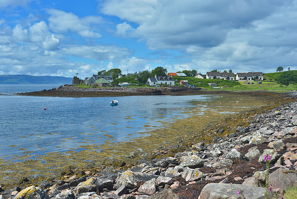
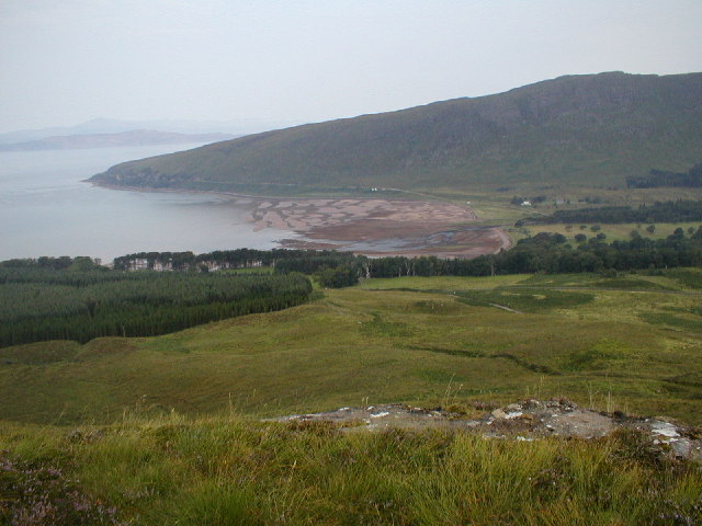
This hill is situated within the stunning landscape of the Scottish Highlands, surrounded by picturesque valleys and rolling hills. Its distinctive shape and commanding presence make it an attractive destination for hikers and nature enthusiasts. The ascent to the summit is relatively moderate, providing an enjoyable challenge for those seeking a rewarding outdoor experience.

From the top of An Tòrr Mòr, visitors are rewarded with breathtaking panoramic views of the surrounding countryside and nearby lochs. On a clear day, it is possible to see the snow-capped peaks of nearby mountains in the distance. The hill is also home to a variety of flora and fauna, including heather, mosses, and a range of bird species.

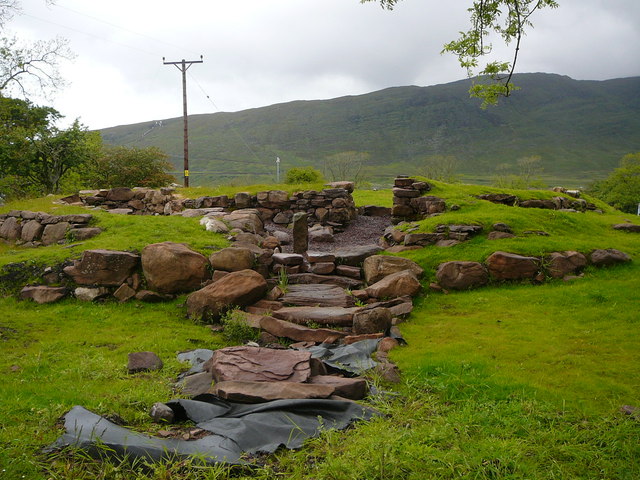
In addition to its natural beauty, An Tòrr Mòr holds historical significance. It is believed to have been a site of ancient settlements, and remnants of Iron Age forts can still be found on its slopes. These archaeological remains add to the intrigue and allure of the hill, attracting history buffs and archaeology enthusiasts.

An Tòrr Mòr offers an opportunity to immerse oneself in the stunning Scottish countryside, offering a blend of natural beauty, historical significance, and a sense of tranquility that is sure to captivate all who visit.

If you have any feedback on the listing, please let us know in the comments section below.

An Tòrr Mòr Images

Images are sourced within 2km of 57.421338/-5.8112116 or Grid Reference NG7143. Thanks to Geograph Open Source API. All images are credited.

Camusterrach Nice late afternoon sunshine. The following day it pi...poured down with rain, all day!
Camusterrach
Nice late afternoon sunshine. The following day it pi...poured down with rain, all day!
Poll Creadha Looking across the little bay on the south-west corner of Applecross.
Poll Creadha
Looking across the little bay on the south-west corner of Applecross.
View over Applecross Bay Taken from the Applecross road near Rubha na Guailne. View over Applecross Bay to Applecross (left) and Milton (right) and on toward Sron na h-Airde Bhaine
View over Applecross Bay
Taken from the Applecross road near Rubha na Guailne. View over Applecross Bay to Applecross (left) and Milton (right) and on toward Sron na h-Airde Bhaine
High and Dry Beached boats at Applecross Bay
High and Dry
Beached boats at Applecross Bay
Junction of road to Achnasheen in Applecross
Minor road past Loch a' Mhullinn This little cul-de-sac ambles south from here, through a few coastal hamlets, and finishes at Loch Toscaig.
Minor road past Loch a' Mhullinn
This little cul-de-sac ambles south from here, through a few coastal hamlets, and finishes at Loch Toscaig.
Foreshore between Milton and Applecross
Applecross Inn
Applecross Inn
Broch excavations at Applecross
Applecross, Applecross Bay - 1981 Applecross, Applecross Bay.
The Applecross peninsula is a peninsula in Wester Ross, Highland, on the west coast of Scotland. The name Applecross is at least 1300 years old and is not used locally to refer to the 19th century village with the pub and post office, lying on the small Applecross Bay, facing the Inner Sound, on the opposite side of which lies the Inner Hebridean island of Raasay.
This row of houses which is often referred to as 'Applecross', and is marked as Applecross on some maps, is actually called 'Shore Street' and is referred to locally just as 'The Street'. The name Applecross applies to all the settlements around the peninsula, including Toscaig, Culduie, Camusterrach, Milltown, Sand, 'The Street', Lonbain and many others. Applecross is also the name of the local estate and the civil parish, which includes Shieldaig and Torridon. The small River Applecross flows into the bay at Applecross.
Extremely isolated, Applecross was only accessible by boat until the early 20th century, and for many years after that the only road access was over one of Scotland's most notoriously treacherous roads, the Bealach na Ba (‘Pass of the Cattle’), which crosses the peninsula and reaches a maximum height of 626 m, below the 774 m high Sgùrr a' Chaorachain. The settlement is now connected via a winding coastal road which travels around the edge of the peninsula to Shieldaig and Torridon. The road skirts the shore of the Inner Sound and Loch Torridon.
Applecross, Applecross Bay - 1981
Applecross, Applecross Bay. The Applecross peninsula is a peninsula in Wester Ross, Highland, on the west coast of Scotland. The name Applecross is at least 1300 years old and is not used locally to refer to the 19th century village with the pub and post office, lying on the small Applecross Bay, facing the Inner Sound, on the opposite side of which lies the Inner Hebridean island of Raasay. This row of houses which is often referred to as 'Applecross', and is marked as Applecross on some maps, is actually called 'Shore Street' and is referred to locally just as 'The Street'. The name Applecross applies to all the settlements around the peninsula, including Toscaig, Culduie, Camusterrach, Milltown, Sand, 'The Street', Lonbain and many others. Applecross is also the name of the local estate and the civil parish, which includes Shieldaig and Torridon. The small River Applecross flows into the bay at Applecross. Extremely isolated, Applecross was only accessible by boat until the early 20th century, and for many years after that the only road access was over one of Scotland's most notoriously treacherous roads, the Bealach na Ba (‘Pass of the Cattle’), which crosses the peninsula and reaches a maximum height of 626 m, below the 774 m high Sgùrr a' Chaorachain. The settlement is now connected via a winding coastal road which travels around the edge of the peninsula to Shieldaig and Torridon. The road skirts the shore of the Inner Sound and Loch Torridon.
Applecross - 1981 The Applecross peninsula is a peninsula in Wester Ross, Highland, on the west coast of Scotland. The name Applecross is at least 1300 years old and is not used locally to refer to the 19th century village with the pub and post office, lying on the small Applecross Bay, facing the Inner Sound, on the opposite side of which lies the Inner Hebridean island of Raasay.
This row of houses which is often referred to as 'Applecross', and is marked as Applecross on some maps, is actually called 'Shore Street' and is referred to locally just as 'The Street'. The name Applecross applies to all the settlements around the peninsula, including Toscaig, Culduie, Camusterrach, Milltown, Sand, 'The Street', Lonbain and many others. Applecross is also the name of the local estate and the civil parish, which includes Shieldaig and Torridon. The small River Applecross flows into the bay at Applecross.
Extremely isolated, Applecross was only accessible by boat until the early 20th century, and for many years after that the only road access was over one of Scotland's most notoriously treacherous roads, the Bealach na Ba (‘Pass of the Cattle’), which crosses the peninsula and reaches a maximum height of 626 m, below the 774 m high Sgùrr a' Chaorachain. The settlement is now connected via a winding coastal road which travels around the edge of the peninsula to Shieldaig and Torridon. The road skirts the shore of the Inner Sound and Loch Torridon.
Applecross - 1981
The Applecross peninsula is a peninsula in Wester Ross, Highland, on the west coast of Scotland. The name Applecross is at least 1300 years old and is not used locally to refer to the 19th century village with the pub and post office, lying on the small Applecross Bay, facing the Inner Sound, on the opposite side of which lies the Inner Hebridean island of Raasay. This row of houses which is often referred to as 'Applecross', and is marked as Applecross on some maps, is actually called 'Shore Street' and is referred to locally just as 'The Street'. The name Applecross applies to all the settlements around the peninsula, including Toscaig, Culduie, Camusterrach, Milltown, Sand, 'The Street', Lonbain and many others. Applecross is also the name of the local estate and the civil parish, which includes Shieldaig and Torridon. The small River Applecross flows into the bay at Applecross. Extremely isolated, Applecross was only accessible by boat until the early 20th century, and for many years after that the only road access was over one of Scotland's most notoriously treacherous roads, the Bealach na Ba (‘Pass of the Cattle’), which crosses the peninsula and reaches a maximum height of 626 m, below the 774 m high Sgùrr a' Chaorachain. The settlement is now connected via a winding coastal road which travels around the edge of the peninsula to Shieldaig and Torridon. The road skirts the shore of the Inner Sound and Loch Torridon.
Pass of the Cattle - 1981 Pass of the Cattle, warning sign.
Bealach na Bà is a historic pass through the mountains of the Applecross peninsula, in Wester Ross in the Scottish Highlands and the name of a famous twisting, single-track mountain road through the pass and mountains.
Pass of the Cattle - 1981
Pass of the Cattle, warning sign. Bealach na Bà is a historic pass through the mountains of the Applecross peninsula, in Wester Ross in the Scottish Highlands and the name of a famous twisting, single-track mountain road through the pass and mountains.
Applecross, Applecross Bay - 1981 Applecross, Applecross Bay.
The Applecross peninsula is a peninsula in Wester Ross, Highland, on the west coast of Scotland. The name Applecross is at least 1300 years old and is not used locally to refer to the 19th century village with the pub and post office, lying on the small Applecross Bay, facing the Inner Sound, on the opposite side of which lies the Inner Hebridean island of Raasay.
This row of houses which is often referred to as 'Applecross', and is marked as Applecross on some maps, is actually called 'Shore Street' and is referred to locally just as 'The Street'. The name Applecross applies to all the settlements around the peninsula, including Toscaig, Culduie, Camusterrach, Milltown, Sand, 'The Street', Lonbain and many others. Applecross is also the name of the local estate and the civil parish, which includes Shieldaig and Torridon. The small River Applecross flows into the bay at Applecross.
Extremely isolated, Applecross was only accessible by boat until the early 20th century, and for many years after that the only road access was over one of Scotland's most notoriously treacherous roads, the Bealach na Ba (‘Pass of the Cattle’), which crosses the peninsula and reaches a maximum height of 626 m, below the 774 m high Sgùrr a' Chaorachain. The settlement is now connected via a winding coastal road which travels around the edge of the peninsula to Shieldaig and Torridon. The road skirts the shore of the Inner Sound and Loch Torridon.
Applecross, Applecross Bay - 1981
Applecross, Applecross Bay. The Applecross peninsula is a peninsula in Wester Ross, Highland, on the west coast of Scotland. The name Applecross is at least 1300 years old and is not used locally to refer to the 19th century village with the pub and post office, lying on the small Applecross Bay, facing the Inner Sound, on the opposite side of which lies the Inner Hebridean island of Raasay. This row of houses which is often referred to as 'Applecross', and is marked as Applecross on some maps, is actually called 'Shore Street' and is referred to locally just as 'The Street'. The name Applecross applies to all the settlements around the peninsula, including Toscaig, Culduie, Camusterrach, Milltown, Sand, 'The Street', Lonbain and many others. Applecross is also the name of the local estate and the civil parish, which includes Shieldaig and Torridon. The small River Applecross flows into the bay at Applecross. Extremely isolated, Applecross was only accessible by boat until the early 20th century, and for many years after that the only road access was over one of Scotland's most notoriously treacherous roads, the Bealach na Ba (‘Pass of the Cattle’), which crosses the peninsula and reaches a maximum height of 626 m, below the 774 m high Sgùrr a' Chaorachain. The settlement is now connected via a winding coastal road which travels around the edge of the peninsula to Shieldaig and Torridon. The road skirts the shore of the Inner Sound and Loch Torridon.
Scene at Applecross Bay
Looking down the shingle beach along the Inner Sound Photographer is standing on the edge of the backshore.
Looking down the shingle beach along the Inner Sound
Photographer is standing on the edge of the backshore.
Moorland near Applecross
Shore Street Applecross
Shoreline at Applecross
Show me another place!

An Tòrr Mòr is located at Grid Ref: NG7143 (Lat: 57.421338, Lng: -5.8112116)

Unitary Authority: Highland

Police Authority: Highlands and Islands

What 3 Words

///certainly.damp.unsecured. Near Kyleakin, Highland

Nearby Locations

An Tòrr Mòr

Related Wikis

Camusteel

Camusteel (Scottish Gaelic: Camas Teile) is a remote crofting and former fishing village in the Applecross peninsula, located less than 1 mile directly...

Applecross

Applecross (Scottish Gaelic: A' Chomraich [ə ˈxoməriç], 'The Sanctuary') is a peninsula north-west of Kyle of Lochalsh in Wester Ross, Scottish Highlands...

Camusterrach

Camusterrach (Scottish Gaelic: Camas Tearach) is a remote hamlet, situated on the west coast of Scotland, on the Applecross peninsula, in Strathcarron...

Applecross Bay

Applecross Bay is large remote tidal coastal embayment, located next to the small fishing village of Applecross and is on the west coast of the Applecross...

Nearby Amenities

Located within 500m of 57.421338,-5.8112116
Created By: Merkaartor 0.13
Lat/Long: 57.4184057/-5.817325
Created By: Merkaartor 0.13
Lat/Long: 57.4181689/-5.8170139
Ford: yes
Lat/Long: 57.4240928/-5.8123334
Ford: yes
Lat/Long: 57.4237292/-5.8182671
Torgarve
Name En: Torgarve
Name Gd: Tòrr Garbh
Place: locality
Source: OS_OpenData_StreetView
Lat/Long: 57.4241913/-5.8113056
Fixme: continue
Lat/Long: 57.4247652/-5.8105603
Ford: yes
Lat/Long: 57.4252194/-5.8093126
Power: pole
Lat/Long: 57.4251948/-5.8104634
Power: pole
Lat/Long: 57.4235135/-5.813229
Power: pole
Lat/Long: 57.4222584/-5.8152133
Power: pole
Lat/Long: 57.4216972/-5.8161872
Power: pole
Lat/Long: 57.4199623/-5.8168423
Power: pole
Lat/Long: 57.4200301/-5.8190565
Power: pole
Lat/Long: 57.4200046/-5.8181732
Power: pole
Lat/Long: 57.4199279/-5.8154669
Power: pole
Lat/Long: 57.4190804/-5.8151231
Power: pole
Lat/Long: 57.418236/-5.8147792
Power: pole
Lat/Long: 57.4173357/-5.8143554
Power: pole
Lat/Long: 57.4236842/-5.8168163
Power: pole
Lat/Long: 57.424034/-5.8123728
Power: pole
Lat/Long: 57.4228648/-5.8142546
Power: pole
Lat/Long: 57.4229086/-5.8159443
Power: pole
Lat/Long: 57.4245308/-5.8115555
Power: pole
Lat/Long: 57.4244821/-5.8114393
The data included in this document is from www.openstreetmap.org. The data is made available under ODbL.

Have you been to An Tòrr Mòr?

Leave your review of An Tòrr Mòr below (or comments, questions and feedback).