Victoria Hill

Hill, Mountain in Argyllshire

Scotland

Victoria Hill

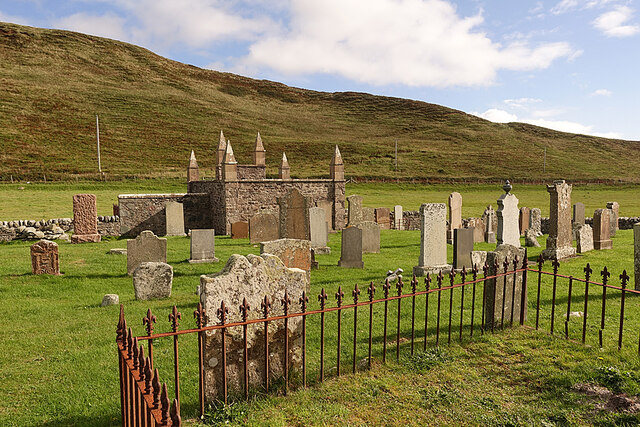
Cladh nam Paitean Burial Ground
Cladh nam Paitean Burial Ground Credit: Elliott Simpson

Victoria Hill, located in Argyllshire, is a prominent natural landmark in the region. Standing at an impressive elevation of 1,200 feet above sea level, this mountain offers breathtaking panoramic views of the surrounding landscapes. Situated in the picturesque Scottish Highlands, Victoria Hill attracts hikers, mountaineers, and nature enthusiasts alike.

Covered in lush greenery, the mountain features a diverse range of flora and fauna, including heather, ferns, and various species of birds. The terrain is characterized by rugged slopes and rocky outcrops, providing a challenging yet rewarding experience for adventurers. The mountain is known for its well-maintained trails, making it accessible to both experienced climbers and beginners.

The summit of Victoria Hill offers unparalleled views of the Argyllshire countryside, with its rolling hills, shimmering lochs, and distant coastal vistas. On clear days, one can even catch a glimpse of the nearby islands of Mull and Islay. The breathtaking scenery attracts photographers and nature lovers who seek to capture the raw beauty of the Scottish wilderness.

Victoria Hill holds historical significance as well. Named in honor of Queen Victoria, the mountain serves as a reminder of the monarch's enduring legacy. It stands as a symbol of the region's rich history and natural heritage.

Overall, Victoria Hill in Argyllshire stands as a majestic and awe-inspiring mountain, offering visitors a chance to immerse themselves in the unparalleled beauty of the Scottish Highlands.

If you have any feedback on the listing, please let us know in the comments section below.

Victoria Hill Images

Images are sourced within 2km of 55.565723/-5.70457 or Grid Reference NR6636. Thanks to Geograph Open Source API. All images are credited.

Cladh nam Paitean Burial Ground
A83 north of Glenbarr Village
Glenbarr War Memorial Situated in an isolated location to the north of Glenbarr, the war memorial is a rustic sandstone cross with a sandstone pillared gateway.
Glenbarr War Memorial
Situated in an isolated location to the north of Glenbarr, the war memorial is a rustic sandstone cross with a sandstone pillared gateway.
Old Milestone by the A83, north of Glenbarr Stone post by the A83, in parish of Killean and Kilchenzie (Kintyre District), North of Glennbarr, South of school, opposite school sign near top of hill.

Inscription reads:-
FROM
CAMBN
13
MILES

Surveyed

Milestone Society National ID: AB_CTTB13
Old Milestone by the A83, north of Glenbarr
Stone post by the A83, in parish of Killean and Kilchenzie (Kintyre District), North of Glennbarr, South of school, opposite school sign near top of hill. Inscription reads:- FROM CAMBN 13 MILES Surveyed Milestone Society National ID: AB_CTTB13
Old Milestone by the A83, south of Glenbarr Milestone by the A83, in parish of Killean and Kilchenzie (Kintyre District), South of Glenbarr, near 'Side Wind' sign, North of end of crash barrier, East side of road.

Inscription reads:-
FROM
CAMPBN
12
MILES

Surveyed

Milestone Society National ID: AB_CTTB12
Old Milestone by the A83, south of Glenbarr
Milestone by the A83, in parish of Killean and Kilchenzie (Kintyre District), South of Glenbarr, near 'Side Wind' sign, North of end of crash barrier, East side of road. Inscription reads:- FROM CAMPBN 12 MILES Surveyed Milestone Society National ID: AB_CTTB12
Triangulation pillar on Victoria Hill, Glenbarr
Old milestone In 2012 the 9 mile stone at Putechan was laid on the ground.  It was not seen in 2019.  This 12 mile stone seems to have survived quite well since 2012.  It is south of Glenbarr near a Side Winds sign.
Old milestone
In 2012 the 9 mile stone at Putechan was laid on the ground. It was not seen in 2019. This 12 mile stone seems to have survived quite well since 2012. It is south of Glenbarr near a Side Winds sign.
Glenbarr Kirk The kirk is now in use as a church hall.
Glenbarr Kirk
The kirk is now in use as a church hall.
Glenbarr Abbey Barr House, the original house on the site, was remodelled about 1815 into a Gothic fantasy, attributed to James Gillespie Graham, and extended in 1844 by the addition of three blocks to the south, each one lower than the next. It is  Category B Listed building, and it is on the Buildings at Risk Register.  See <span class="nowrap"><a title="https://canmore.org.uk/site/83067/glenbarr-abbey," rel="nofollow ugc noopener" href="https://canmore.org.uk/site/83067/glenbarr-abbey,">Link</a><img style="margin-left:2px;" alt="External link" title="External link - shift click to open in new window" src="https://s1.geograph.org.uk/img/external.png" width="10" height="10"/></span> <span class="nowrap"><a title="http://portal.historicenvironment.scot/designation/LB12009" rel="nofollow ugc noopener" href="http://portal.historicenvironment.scot/designation/LB12009">Link</a><img style="margin-left:2px;" alt="External link" title="External link - shift click to open in new window" src="https://s1.geograph.org.uk/img/external.png" width="10" height="10"/></span> and <span class="nowrap"><a title="https://www.buildingsatrisk.org.uk/details/991413" rel="nofollow ugc noopener" href="https://www.buildingsatrisk.org.uk/details/991413">Link</a><img style="margin-left:2px;" alt="External link" title="External link - shift click to open in new window" src="https://s1.geograph.org.uk/img/external.png" width="10" height="10"/></span>
Glenbarr Abbey
Barr House, the original house on the site, was remodelled about 1815 into a Gothic fantasy, attributed to James Gillespie Graham, and extended in 1844 by the addition of three blocks to the south, each one lower than the next. It is Category B Listed building, and it is on the Buildings at Risk Register. See LinkExternal link LinkExternal link and LinkExternal link
Cladh nam Paitean The eye-catching pinnacles are not part of a gateway, but the whole thing appears to be the subject of confusing information. <span class="nowrap"><a title="https://canmore.org.uk/site/38481/cladh-nam-paitean-burial-ground" rel="nofollow ugc noopener" href="https://canmore.org.uk/site/38481/cladh-nam-paitean-burial-ground">Link</a><img style="margin-left:2px;" alt="External link" title="External link - shift click to open in new window" src="https://s1.geograph.org.uk/img/external.png" width="10" height="10"/></span> gives some information about its origins, and says its alternative name is 'Macalister of Glenbarr Burial Enclosure', but says nothing more about Macalisters of Glenbarr. It also describes it as 'a modern burial ground' but goes on to say that it was in existence by 1699, and the earliest gravestone bears the date 1731. It is a Category C Listed building, using the same names, but it is mapped as Killegruer Burial Ground. The entrance is not, as I expected, through the archway, but through a modest gate in the south dyke.
Cladh nam Paitean
The eye-catching pinnacles are not part of a gateway, but the whole thing appears to be the subject of confusing information. LinkExternal link gives some information about its origins, and says its alternative name is 'Macalister of Glenbarr Burial Enclosure', but says nothing more about Macalisters of Glenbarr. It also describes it as 'a modern burial ground' but goes on to say that it was in existence by 1699, and the earliest gravestone bears the date 1731. It is a Category C Listed building, using the same names, but it is mapped as Killegruer Burial Ground. The entrance is not, as I expected, through the archway, but through a modest gate in the south dyke.
Killegruer Burial Ground Some of the gravestones in the neatly kept burial ground.
Killegruer Burial Ground
Some of the gravestones in the neatly kept burial ground.
Rough Enclosure We wondered if this enclosure of stones was perhaps one of the older graves in the burial ground, but there was nothing to tell us the answer.
Rough Enclosure
We wondered if this enclosure of stones was perhaps one of the older graves in the burial ground, but there was nothing to tell us the answer.
Macalister of Glenbarr Burial Ground I am assuming that the six-pinnacled building on the east side of the burial ground is the burial enclosure of the Macalisters of Glenbarr.
Macalister of Glenbarr Burial Ground
I am assuming that the six-pinnacled building on the east side of the burial ground is the burial enclosure of the Macalisters of Glenbarr.
Carved Gravestone The relief carving on this stone seems to be surviving exposure to the westerly winds from the sea, but we were still unsure exactly what it depicts.
Carved Gravestone
The relief carving on this stone seems to be surviving exposure to the westerly winds from the sea, but we were still unsure exactly what it depicts.
Cladh nam Paitean The name may mean 'graveyard of the drowned' from the story that it was set up to bury some shipwrecked sailors. It is certainly very close to the sea.
Cladh nam Paitean
The name may mean 'graveyard of the drowned' from the story that it was set up to bury some shipwrecked sailors. It is certainly very close to the sea.
Glenbarr War Memorial The memorial is sited right beside the A83 and is not easy to access as there's no  convenient parking and it's hazardous walking along the A83 if it's busy. See <span class="nowrap"><a title="https://canmore.org.uk/site/332499/glenbarr-barlea-glenbarr-war-memorial" rel="nofollow ugc noopener" href="https://canmore.org.uk/site/332499/glenbarr-barlea-glenbarr-war-memorial">Link</a><img style="margin-left:2px;" alt="External link" title="External link - shift click to open in new window" src="https://s1.geograph.org.uk/img/external.png" width="10" height="10"/></span> for a full transcription of the inscription and list of the men commemorated.
Glenbarr War Memorial
The memorial is sited right beside the A83 and is not easy to access as there's no convenient parking and it's hazardous walking along the A83 if it's busy. See LinkExternal link for a full transcription of the inscription and list of the men commemorated.
Glenacardoch Farm The farm is perched high above the sea, at the top of a gentle rise. In the background is the Isle of Islay.
Glenacardoch Farm
The farm is perched high above the sea, at the top of a gentle rise. In the background is the Isle of Islay.
Victoria Hill It's not an impressive hill, and it may not even have had a name until the 19th century. Barlea Farm is to the left, hidden by trees.
Victoria Hill
It's not an impressive hill, and it may not even have had a name until the 19th century. Barlea Farm is to the left, hidden by trees.
Show me another place!

Victoria Hill is located at Grid Ref: NR6636 (Lat: 55.565723, Lng: -5.70457)

Unitary Authority: Argyll and Bute

Police Authority: Argyll and West Dunbartonshire

What 3 Words

///select.prepped.noted. Near Campbeltown, Argyll & Bute

Nearby Locations

Victoria Hill

Related Wikis

Glenbarr

Glenbarr (Scottish Gaelic: Am Bàrr, pronounced [əm ˈpaːrˠ]) is a village in Argyll and Bute, Scotland. It lies on the west coast of the Kintyre peninsula...

Barr Water

Barr Water is a westerly flowing river of the Kintyre peninsula in the southwest Scottish Highlands. Rising at the diminutive Loch Losgainn near the hill...

Muasdale

Muasdale (Scottish Gaelic: Muasdal) is a hamlet on the western coast of the Kintyre Peninsula of Scotland. As of the year 2000 Muasdale had a population...

Bellochantuy

Bellochantuy (; Scottish Gaelic: Bealach an t-Suidhe, pronounced [ˈpjal̪ˠəx ən̪ˠ ˈt̪ʰɯjə]) is a small coastal hamlet located on the A83 in Argyll, Scotland...

Nearby Amenities

Located within 500m of 55.565723,-5.70457
Power: pole
Lat/Long: 55.5616801/-5.7069786
Power: pole
Lat/Long: 55.5672194/-5.6982093
Power: pole
Lat/Long: 55.5664685/-5.6997791
Power: pole
Lat/Long: 55.5660642/-5.7006016
Power: pole
Lat/Long: 55.5656599/-5.7014242
Power: pole
Lat/Long: 55.5651796/-5.7020962
Power: pole
Lat/Long: 55.5646811/-5.7028165
Power: pole
Lat/Long: 55.5637204/-5.7041767
Power: pole
Lat/Long: 55.5632127/-5.7048594
Power: pole
Lat/Long: 55.5627263/-5.7055583
Power: pole
Lat/Long: 55.5622277/-5.7062625
Power: pole
Lat/Long: 55.5642038/-5.7034616
Power: pole
Lat/Long: 55.5668546/-5.6989942
Power: pole
Lat/Long: 55.5678935/-5.6984898
Noexit: yes
Lat/Long: 55.567331/-5.6973834
Power: pole
Lat/Long: 55.5687141/-5.6989539
The data included in this document is from www.openstreetmap.org. The data is made available under ODbL.

Have you been to Victoria Hill?

Leave your review of Victoria Hill below (or comments, questions and feedback).