Am Binnein

Hill, Mountain in Argyllshire

Scotland

Am Binnein

Fences at Ardvergnish An isolated farmhouse below Ben More.
An old holiday picture from years ago, but more recent ones don't show much change.
Fences at Ardvergnish Credit: Des Blenkinsopp

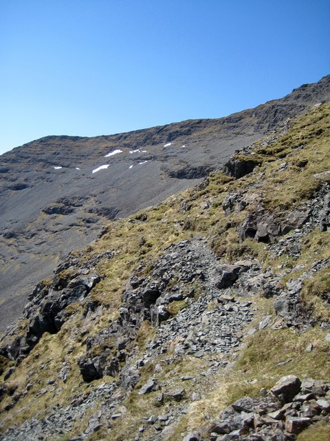
Am Binnein is a prominent hill located in Argyllshire, Scotland. It is part of the stunning Ben Cruachan range and stands at an impressive height of 1,130 meters (3,707 feet). The hill is known for its challenging yet rewarding ascent, attracting both experienced climbers and nature enthusiasts alike.

The name "Am Binnein" translates to "the pinnacle" in Gaelic, which is quite fitting as it offers breathtaking panoramic views of the surrounding countryside. On a clear day, one can see the beautiful Loch Etive, the shimmering waters of Loch Awe, and even the distant peaks of the Glen Coe mountains.

The climb up Am Binnein can be quite demanding, with steep and rocky paths leading to the summit. However, the effort is well worth it as the hill provides a true sense of achievement and offers a sense of peace and solitude that is hard to find elsewhere. The route to the top is adorned with picturesque waterfalls, lush greenery, and an array of wildflowers and wildlife, adding to the allure of the experience.

The hill is also a popular spot for birdwatching, with several species of birds, including golden eagles, peregrine falcons, and buzzards, commonly spotted in the area. Additionally, the hill is home to a variety of plants and trees, such as heather and oak, creating a diverse and vibrant ecosystem.

Overall, Am Binnein is a stunning natural landmark in Argyllshire, offering a challenging yet rewarding climb and breathtaking views that showcase the beauty of the Scottish countryside.

If you have any feedback on the listing, please let us know in the comments section below.

Am Binnein Images

Images are sourced within 2km of 56.403291/-6.0112859 or Grid Reference NM5230. Thanks to Geograph Open Source API. All images are credited.

Fences at Ardvergnish An isolated farmhouse below Ben More.
An old holiday picture from years ago, but more recent ones don't show much change.
Fences at Ardvergnish
An isolated farmhouse below Ben More. An old holiday picture from years ago, but more recent ones don't show much change.
Tree beside the B8073
Benchmark by Loch Scridain The OS description is RIVET TOP S PARA BR 2.8M SW C STR. There is a fine view across Loch Scridain as the Allt na Coille Moire flows into it.
Benchmark by Loch Scridain
The OS description is RIVET TOP S PARA BR 2.8M SW C STR. There is a fine view across Loch Scridain as the Allt na Coille Moire flows into it.
Ridge rising towards Am Binnein Am Binnein is a location along the rising ridge. Beyond that, the ridge goes through convolutions ultimately reaching Ben More's summit which at the time the image was recorded was concealed by mist.
Ridge rising towards Am Binnein
Am Binnein is a location along the rising ridge. Beyond that, the ridge goes through convolutions ultimately reaching Ben More's summit which at the time the image was recorded was concealed by mist.
Ardvergnish Farm The farm of Ardvergnish below Ben More.
Ardvergnish Farm
The farm of Ardvergnish below Ben More.
Loch Beg The shoreline of Loch Beg. Seen across the loch is Kinloch hotel.
Loch Beg
The shoreline of Loch Beg. Seen across the loch is Kinloch hotel.
Ardvergnish Mull farm in the lea of Ben More.
Ardvergnish
Mull farm in the lea of Ben More.
Loch Beg
Loch Beg
Old Milestone, B8035, Loch Beg Located on the West side of road, overlooking bay. Cast Iron post, Blaydon design. 

Lost since last survey. 

Milestone Society National ID: AB_MLSAIF19
Old Milestone, B8035, Loch Beg
Located on the West side of road, overlooking bay. Cast Iron post, Blaydon design. Lost since last survey. Milestone Society National ID: AB_MLSAIF19
Shore of Loch Scridain  below Dererach Dererach is the isolated house seen at the centre of the image, The B8035 passes in front of it.
Maol na Coille Mòire is the hill top above the trees.
Shore of Loch Scridain below Dererach
Dererach is the isolated house seen at the centre of the image, The B8035 passes in front of it. Maol na Coille Mòire is the hill top above the trees.
Ben More South Ridge Looking towards the South Ridge from below the South East Ridge
Ben More South Ridge
Looking towards the South Ridge from below the South East Ridge
Sitting at the bend of Allt Àirigh Eachainn Went up Ben More's quiet side. Sat to eat lunch at this bend in the burn, and much to my surprise a Golden Eagle started to soar around myself. In the background of this image is Ben More to the left and A' Chìoch to the right.
Sitting at the bend of Allt Àirigh Eachainn
Went up Ben More's quiet side. Sat to eat lunch at this bend in the burn, and much to my surprise a Golden Eagle started to soar around myself. In the background of this image is Ben More to the left and A' Chìoch to the right.
South ridge of Ben More You may pick out Jura in the distance.
South ridge of Ben More
You may pick out Jura in the distance.
Ben More - south ridge Looking south along the southern ridge of Ben More. Beyond can be seen Loch Scidain
Ben More - south ridge
Looking south along the southern ridge of Ben More. Beyond can be seen Loch Scidain
Am Binnein, Isle of Mull Am Binnein 375m on right with Ben More summit just visible on left.
Am Binnein, Isle of Mull
Am Binnein 375m on right with Ben More summit just visible on left.
Lochan on Ben More On Am Binnein on the southern approaches to Ben More.
Lochan on Ben More
On Am Binnein on the southern approaches to Ben More.
SW slopes of Ben More Looking down the wet grassy slopes to forestry and Loch Scridain
SW slopes of Ben More
Looking down the wet grassy slopes to forestry and Loch Scridain
Looking SW down upper slopes of Ben More Looking down the slope towards Loch Scridain from about 2000 feet. Ross of Mull in the background. The small cairn may indicate where to turn downhill in the mist as this slope is approached from the higher part of the hill in a more westerly direction.
Looking SW down upper slopes of Ben More
Looking down the slope towards Loch Scridain from about 2000 feet. Ross of Mull in the background. The small cairn may indicate where to turn downhill in the mist as this slope is approached from the higher part of the hill in a more westerly direction.
Show me another place!

Am Binnein is located at Grid Ref: NM5230 (Lat: 56.403291, Lng: -6.0112859)

Unitary Authority: Argyll and Bute

Police Authority: Argyll and West Dunbartonshire

What 3 Words

///reclaimed.poses.slimming. Near Lochbuie, Argyll & Bute

Nearby Locations

Am Binnein

Related Wikis

Aird of Kinloch

Aird of Kinloch (Gaelic:An Àird) is a rocky outcrop between Loch Scridain and Loch Beg on the Isle of Mull, Argyll and Bute, Scotland. == References ==

Ben More (Mull)

Ben More (Scottish Gaelic: Beinn Mhòr, meaning "great mountain") is the highest mountain and only Munro (mountains in Scotland that reach an elevation...

Pennyghael

Pennyghael (Scottish Gaelic: Peighinn nan Gàidheal) is a small village in the Ross of Mull, Argyll and Bute, Scotland. It is located along the A849 road...

Isle of Mull

The Isle of Mull (Scottish Gaelic: An t-Eilean Muileach [əɲ ˈtʲʰelan ˈmuləx]) or just Mull (Scots pronunciation: [mʌl]; Scottish Gaelic: Muile [ˈmulə]...

Nearby Amenities

Located within 500m of 56.403291,-6.0112859
Am Binnein
Ele: 375
Natural: peak
Lat/Long: 56.4032174/-6.0121708
The data included in this document is from www.openstreetmap.org. The data is made available under ODbL.

Have you been to Am Binnein?

Leave your review of Am Binnein below (or comments, questions and feedback).