An Càrn Liath

Hill, Mountain in Inverness-shire

Scotland

An Càrn Liath

Memorial for Jan Vermeiren Jan Vermeiren, a 25 year old Belgian from Wommelgem, died in a fall of some 200m from the summit of the Storr in July 2013. He was camping here on top of the hill with three friends. It is believed he ran over the edge of the hill while trying to retrieve a piece of equipment that was blowing away. This plaque marks the spot from which he fell.
I'm not a fan of such memorials in wild places - but I understand the motivation to put them there...
Memorial for Jan Vermeiren Credit: John Allan

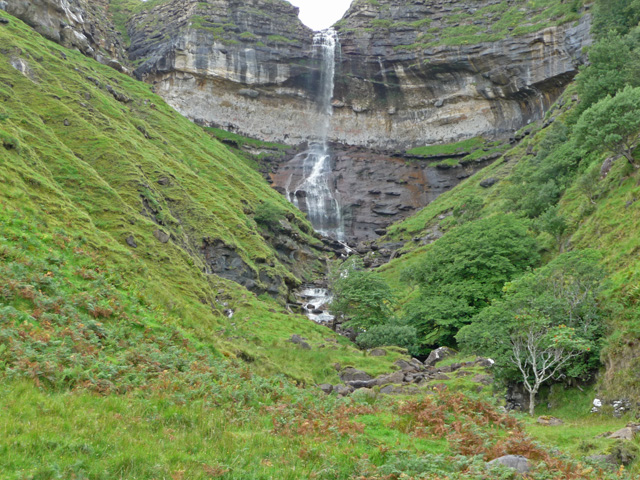
An Càrn Liath, located in Inverness-shire, is a prominent hill/mountain in the Scottish Highlands. With an elevation of 1,006 meters (3,301 feet), it forms part of the northwest ridge of the famous Cairngorms mountain range. The name "An Càrn Liath" translates to "the grey cairn" in Gaelic, which is a fitting description of its distinctive appearance.

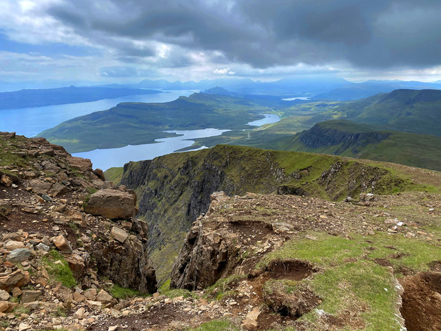
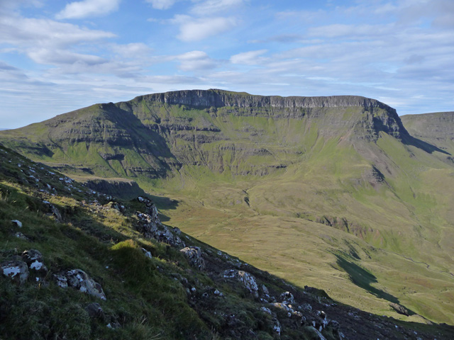
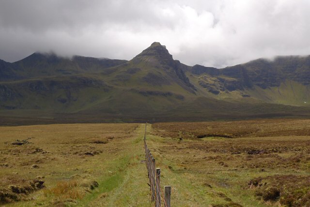
This mountain is a popular destination for hikers, mountaineers, and nature enthusiasts, offering breathtaking panoramic views of the surrounding landscape. Its rugged terrain, characterized by rocky slopes and scree, provides a challenging but rewarding ascent for experienced climbers. The summit of An Càrn Liath presents a stunning vista, showcasing the vast expanse of the Cairngorms National Park and the nearby peaks.

The hill/mountain is known for its diverse flora and fauna, with various species of birds, mammals, and plants inhabiting the area. Ptarmigans, red grouse, golden eagles, and mountain hares are some of the wildlife that can be spotted in this region. During the summer months, the slopes are adorned with colorful alpine flowers, adding to the natural beauty of the landscape.

An Càrn Liath is easily accessible from the nearby town of Aviemore, with several well-marked trails leading to its summit. However, it is essential for visitors to be well-prepared and equipped with appropriate clothing and gear, as the weather conditions can be unpredictable and change rapidly in the Scottish Highlands.

Overall, An Càrn Liath offers a memorable and challenging outdoor experience, combining stunning vistas, rich biodiversity, and a sense of adventure for those who choose to explore its slopes.

If you have any feedback on the listing, please let us know in the comments section below.

An Càrn Liath Images

Images are sourced within 2km of 57.523391/-6.1838116 or Grid Reference NG4955. Thanks to Geograph Open Source API. All images are credited.

Memorial for Jan Vermeiren Jan Vermeiren, a 25 year old Belgian from Wommelgem, died in a fall of some 200m from the summit of the Storr in July 2013. He was camping here on top of the hill with three friends. It is believed he ran over the edge of the hill while trying to retrieve a piece of equipment that was blowing away. This plaque marks the spot from which he fell.
I'm not a fan of such memorials in wild places - but I understand the motivation to put them there...
Memorial for Jan Vermeiren
Jan Vermeiren, a 25 year old Belgian from Wommelgem, died in a fall of some 200m from the summit of the Storr in July 2013. He was camping here on top of the hill with three friends. It is believed he ran over the edge of the hill while trying to retrieve a piece of equipment that was blowing away. This plaque marks the spot from which he fell. I'm not a fan of such memorials in wild places - but I understand the motivation to put them there...
Early season snow on The Storr A day of sunshine and wintry showers on the hills of Trotternish.
Early season snow on The Storr
A day of sunshine and wintry showers on the hills of Trotternish.
The Storr The Storr is made up of numerous lava flows on a base of siltstone and mudstone, making the whole structure unstable. The pinnacles including the Old Man of Storr are rafts of lava that have slipped down the slope.
The Storr
The Storr is made up of numerous lava flows on a base of siltstone and mudstone, making the whole structure unstable. The pinnacles including the Old Man of Storr are rafts of lava that have slipped down the slope.
An Storr A telephoto shot of the Storr from above Oscaig on Raasay. The Old Man of Storr and Needle Rock are visible below and to the right of the summit.
An Storr
A telephoto shot of the Storr from above Oscaig on Raasay. The Old Man of Storr and Needle Rock are visible below and to the right of the summit.
'Panorama' to the north-west A true panorama is 360º, and this is only part of such a view, so not a true panorama. It takes in most of Trotternish and Beinn Tianabhaig on Skye, and the summit of Dùn Caan and the western part of Raasay.
'Panorama' to the north-west
A true panorama is 360º, and this is only part of such a view, so not a true panorama. It takes in most of Trotternish and Beinn Tianabhaig on Skye, and the summit of Dùn Caan and the western part of Raasay.
The table A flat area of grass that you come upon unexpectedly in this area of the Trotternish Ridge. It is a little smaller than a typical football pitch and fairly level, most unusual around here.
The table
A flat area of grass that you come upon unexpectedly in this area of the Trotternish Ridge. It is a little smaller than a typical football pitch and fairly level, most unusual around here.
The Storr Telephoto shot, showing the summit and the Old Man.
The Storr
Telephoto shot, showing the summit and the Old Man.
Cliff face on the southeast side of The Storr
Ridge running north from The Storr
Gully close to the summit of the Storr The hill, in common with much of the rest of the Trotternish Ridge, is geologically active. There are frequent, sometimes very noisy, rock falls. Some of the boulders here look to be destined to drop to Coire Faoin in the fairly near future.
Gully close to the summit of the Storr
The hill, in common with much of the rest of the Trotternish Ridge, is geologically active. There are frequent, sometimes very noisy, rock falls. Some of the boulders here look to be destined to drop to Coire Faoin in the fairly near future.
Path behind the Old Man of Storr The path leads round the back of the Old Man and into Coire Faoin, directly under the cliff below the Storr summit.
Path behind the Old Man of Storr
The path leads round the back of the Old Man and into Coire Faoin, directly under the cliff below the Storr summit.
Basalt boulder near Needle Rock The black rock beside the path to Needle Rock is made from the same basaltic gabbro material as the Old Man, Needle Rock and the other rock features below the Storr escarpment.  The basalt layer is a volcanic deposit on top of other, older rocks, whose mechanical stability has suffered from the weight of the deposit, causing a landslip running along the eastern side of the Trotternish peninsula.
Basalt boulder near Needle Rock
The black rock beside the path to Needle Rock is made from the same basaltic gabbro material as the Old Man, Needle Rock and the other rock features below the Storr escarpment. The basalt layer is a volcanic deposit on top of other, older rocks, whose mechanical stability has suffered from the weight of the deposit, causing a landslip running along the eastern side of the Trotternish peninsula.
On the north ridge of the Storr Looking towards the summit, just clear of the top of the clouds. It's a lovely day up here!
On the north ridge of the Storr
Looking towards the summit, just clear of the top of the clouds. It's a lovely day up here!
Old Man of Storr
Old Man of Storr
Reflecting on Pinnacles of the Storr
Photographers above the Old Man of Storr Visitors gathered on a viewpoint north of the pinnacle.
Photographers above the Old Man of Storr
Visitors gathered on a viewpoint north of the pinnacle.
Pinnacles below the Storr A group of pinnacles in the landslip landscape below the Storr.
The largest of them, in the centre of the picture, is the 50m tall Old Man of Storr.
Pinnacles below the Storr
A group of pinnacles in the landslip landscape below the Storr. The largest of them, in the centre of the picture, is the 50m tall Old Man of Storr.
Lochan below the Storr Unnamed - see <a href="https://www.geograph.org.uk/photo/779855">NG5054 : Unnamed lochan below the Storr</a>.
In the background is the Sound of Raasay, with Rona on the left, and Raasay on the right. The Applecross Peninsula is beyond.
Lochan below the Storr
Unnamed - see NG5054 : Unnamed lochan below the Storr. In the background is the Sound of Raasay, with Rona on the left, and Raasay on the right. The Applecross Peninsula is beyond.
Show me another place!

An Càrn Liath is located at Grid Ref: NG4955 (Lat: 57.523391, Lng: -6.1838116)

Unitary Authority: Highland

Police Authority: Highlands and Islands

What 3 Words

///hill.motive.transmit. Near Uig, Highland

Related Wikis

Hartaval

Hartaval (669 m) is a hill on the Isle of Skye. It is located on the Trotternish peninsula in the north of the isle, and is the second highest peak on...

The Storr

The Storr (Scottish Gaelic: An Stòr) is a rocky hill on the Trotternish peninsula of the Isle of Skye in Scotland. The hill presents a steep rocky eastern...

Sgùrr a' Mhadaidh Ruaidh

Sgùrr a' Mhadaidh Ruaidh (Gaelic for: Peak of the red fox) is a summit in the Trotternish range of hills in the north of the Isle of Skye, Scotland. It...

Storr Lochs Hydro-Electric Scheme

Storr Lochs is a hydro-electric power station built on the Isle of Skye, Inner Hebrides, Scotland and commissioned in 1952. It was built by the North of...

Bearreraig Waterfall

Bearreraig Waterfall is a waterfall of Scotland.It is located on the Trotternish peninsula of the island of Skye, on the Bearreraig River which runs from...

Lealt, Skye

Lealt (Scottish Gaelic: An Leathallt) is a crofting township, on the western coastline of the Sound of Raasay on the Trotternish peninsula of Skye, in...

Bearreraig Sandstone Formation

The Bearreraig Sandstone Formation is a geological formation in Scotland. It preserves fossils dating back to the lower to middle parts of the Jurassic...

Sound of Raasay

The Sound of Raasay (Scottish Gaelic: Linne Ratharsair) is the sound between the islands of Raasay and Skye. == See also == Inner Sound, Scotland Isle...

Nearby Amenities

Located within 500m of 57.523391,-6.1838116
Fixme: cliff continues?
Lat/Long: 57.5241587/-6.1848358
An Carn Liath
Place: locality
Lat/Long: 57.5229931/-6.184262
The data included in this document is from www.openstreetmap.org. The data is made available under ODbL.

Have you been to An Càrn Liath?

Leave your review of An Càrn Liath below (or comments, questions and feedback).