Am Bàsteir

Hill, Mountain in Inverness-shire

Scotland

Am Bàsteir

The Easy Cuillin The summit of Bruach na Frithe as seen from high up in Fionn Choire. This is the easiest Munro summit on the main Black Cuillin ridge. Even so there is some easy scrambling to reach the summit and some big drops. It's the sensible option with four Jack Russells in tow! A glorious day on glorious mountains.
The Easy Cuillin Credit: Adam Ward

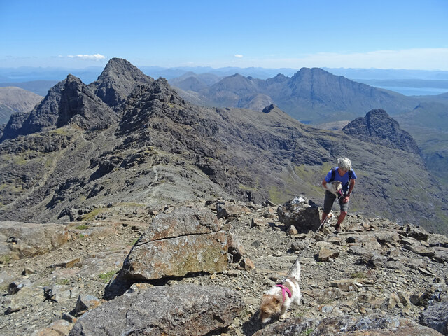
Am Bàsteir is a mountain located in the Inverness-shire region of Scotland. It is part of the Cuillin range on the Isle of Skye, known for its rugged and dramatic landscape. Standing at a height of 929 meters (3,048 feet), Am Bàsteir is a popular destination for hikers and climbers seeking a challenging and rewarding ascent.

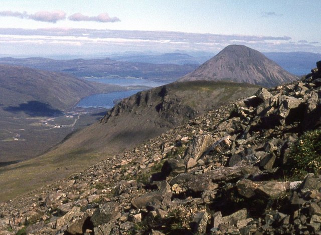
The mountain is characterized by its steep slopes, rocky terrain, and jagged peaks, making it a formidable but exhilarating climb for experienced mountaineers. The summit offers stunning panoramic views of the surrounding Cuillin mountains, as well as the nearby Loch Brittle and the Isle of Rum.

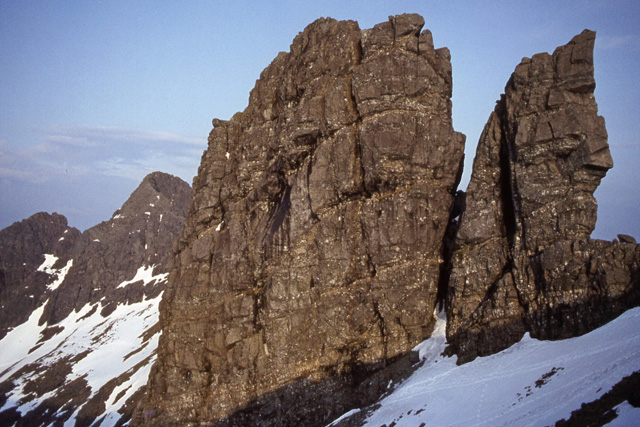
Am Bàsteir is known for its distinctive rock formation known as the "Basteir Tooth," a prominent feature that juts out from the mountain's ridge. This rock pinnacle is a popular spot for climbers looking to test their skills on challenging vertical faces.

Overall, Am Bàsteir is a must-visit destination for outdoor enthusiasts looking to explore the rugged beauty of the Scottish Highlands and experience the thrill of conquering a mountain with breathtaking views.

If you have any feedback on the listing, please let us know in the comments section below.

Am Bàsteir Images

Images are sourced within 2km of 57.247934/-6.2029312 or Grid Reference NG4625. Thanks to Geograph Open Source API. All images are credited.

The Easy Cuillin The summit of Bruach na Frithe as seen from high up in Fionn Choire. This is the easiest Munro summit on the main Black Cuillin ridge. Even so there is some easy scrambling to reach the summit and some big drops. It's the sensible option with four Jack Russells in tow! A glorious day on glorious mountains.
The Easy Cuillin
The summit of Bruach na Frithe as seen from high up in Fionn Choire. This is the easiest Munro summit on the main Black Cuillin ridge. Even so there is some easy scrambling to reach the summit and some big drops. It's the sensible option with four Jack Russells in tow! A glorious day on glorious mountains.
Bla Bheinn Through the Gap Lovely view of Bla Bheinn in a gap of the steep ground between Am Basteir and Bruach na Frithe.
Bla Bheinn Through the Gap
Lovely view of Bla Bheinn in a gap of the steep ground between Am Basteir and Bruach na Frithe.
Bruach na Frithe Summit Slopes Just about at the summit of Bruach na Frithe, the easiest black Cuillin Munro to climb. The Munros of Bla Bheinn, Sgurr nan Gillean and Am Basteir are the peaks as seen from right to left. A figure can just be seen on the summit of Sgurr an Fhionn-Choire the peak in the centre. With 4 terriers and steep terrain we are not taking any chances - 2 are being carried and 2  are on the lead!
Bruach na Frithe Summit Slopes
Just about at the summit of Bruach na Frithe, the easiest black Cuillin Munro to climb. The Munros of Bla Bheinn, Sgurr nan Gillean and Am Basteir are the peaks as seen from right to left. A figure can just be seen on the summit of Sgurr an Fhionn-Choire the peak in the centre. With 4 terriers and steep terrain we are not taking any chances - 2 are being carried and 2 are on the lead!
Glamaig Across the Moorland Sgurr Mhairi the western peak of Glamaig as seen across the moorland north of Fionn Choire.
Glamaig Across the Moorland
Sgurr Mhairi the western peak of Glamaig as seen across the moorland north of Fionn Choire.
Sgùrr na h-Uamha from ridge close to Sgùrr Beag Sgùrr na h-Uamha is at the centre of the image. Sgùrr Beag rises just to the left, out of view. The ridge from which the photograph was taken rises behind the camera position to Sgùrr nan Gillean.
Sgùrr na h-Uamha from ridge close to Sgùrr Beag
Sgùrr na h-Uamha is at the centre of the image. Sgùrr Beag rises just to the left, out of view. The ridge from which the photograph was taken rises behind the camera position to Sgùrr nan Gillean.
West ridge of Sgùrr nan Gillean The west ridge of Sgùrr nan Gillean descending from the summit, its route emphasised by the pale line of the path along its crest. Beyond the col the ridge rises to Am Basteir which is the nearest of the peaks with mist wisping around its summit.
Coire a' Bhàsteir is the rocky bowl to the right of the ridge and Sgùrr a' Bhàsteir is the more brightly lit mountain above it, also misted.
West ridge of Sgùrr nan Gillean
The west ridge of Sgùrr nan Gillean descending from the summit, its route emphasised by the pale line of the path along its crest. Beyond the col the ridge rises to Am Basteir which is the nearest of the peaks with mist wisping around its summit. Coire a' Bhàsteir is the rocky bowl to the right of the ridge and Sgùrr a' Bhàsteir is the more brightly lit mountain above it, also misted.
Sgurr Beag A view to the 764m summit of Sgurr Beag, a prominence on the ridge running south from Sgurr nan Gillean.
Sgurr Beag
A view to the 764m summit of Sgurr Beag, a prominence on the ridge running south from Sgurr nan Gillean.
Pinnacle Ridge, Sgurr nan Gillean
Flank of Bruach na Frithe Sligachan below and Glamaig above. Raasay and mainland mountains beyond.
Flank of Bruach na Frithe
Sligachan below and Glamaig above. Raasay and mainland mountains beyond.
Resting before the final summit push on a Cuillin summit On Bruach na Frithe with Loch Harport in the distance. Hills on Harris line the horizon.
Resting before the final summit push on a Cuillin summit
On Bruach na Frithe with Loch Harport in the distance. Hills on Harris line the horizon.
Sgùrr nan Gillean's southeast ridge Loch Scavaig and the Sleat peninsula lie beyond.
Sgùrr nan Gillean's southeast ridge
Loch Scavaig and the Sleat peninsula lie beyond.
Coir' a' Tairneilear A view to the back wall of the coire, with the peaks of Sgurr na Bairnich on the left and Bidein Druim nan Ramh on the right.
Coir' a' Tairneilear
A view to the back wall of the coire, with the peaks of Sgurr na Bairnich on the left and Bidein Druim nan Ramh on the right.
Pool on the Allt Coir' a' Tairneilear Clear water running through and over the boulders in lower Coir' a' Tairneilear.
Pool on the Allt Coir' a' Tairneilear
Clear water running through and over the boulders in lower Coir' a' Tairneilear.
West ridge, Sgurr nan Gillean View from near the top of the SE ridge on a typical cloudy day.
Am Basteir stands guard on the left at the head of Coire a' Bhasteir,  with Sgurr an Fhionn Choire to its left, and Bruach na Frithe beyond. Sgurr a' Bhasteir is across the corrie in the centre.
West ridge, Sgurr nan Gillean
View from near the top of the SE ridge on a typical cloudy day. Am Basteir stands guard on the left at the head of Coire a' Bhasteir, with Sgurr an Fhionn Choire to its left, and Bruach na Frithe beyond. Sgurr a' Bhasteir is across the corrie in the centre.
Coire Riabhach Looking east towards the Red Hills - Beinn Dearg Mhor (left), Beinn Dearg Mheadhonach and Marsco. Loch a' Coire Riabhach is in the middle distance.
Coire Riabhach
Looking east towards the Red Hills - Beinn Dearg Mhor (left), Beinn Dearg Mheadhonach and Marsco. Loch a' Coire Riabhach is in the middle distance.
Sgurr nan Gillean - The Knight's Peak Looking from the A863, about 5km to the north.
Sgurr nan Gillean - The Knight's Peak
Looking from the A863, about 5km to the north.
On the summit of Bruach na Frithe Forty years later the immediate topography looked the same, and benefited from less cloud revealing also Sgurr nan Gillean on the Cuillin ridge. See <a href="https://www.geograph.org.uk/photo/138174">NG4625 : Summit of Bruach na Frithe</a> in 2004.
On the summit of Bruach na Frithe
Forty years later the immediate topography looked the same, and benefited from less cloud revealing also Sgurr nan Gillean on the Cuillin ridge. See NG4625 : Summit of Bruach na Frithe in 2004.
Am Basteir A classic view of Am Basteir.  Identical viewpoint to that of Ian Thomas taken 39 years later.  <a href="https://www.geograph.org.uk/photo/17281">NG4625 : Am Basteir</a>.  There is no no discernible change to the rock architecture from rock falls etc.

My annotated Munro's Tables shows that I climbed Am Basteir but not the Tooth that day.  Regrettably I remember little of the fun!
Am Basteir
A classic view of Am Basteir. Identical viewpoint to that of Ian Thomas taken 39 years later. NG4625 : Am Basteir. There is no no discernible change to the rock architecture from rock falls etc. My annotated Munro's Tables shows that I climbed Am Basteir but not the Tooth that day. Regrettably I remember little of the fun!
Show me another place!

Am Bàsteir is located at Grid Ref: NG4625 (Lat: 57.247934, Lng: -6.2029312)

Unitary Authority: Highland

Police Authority: Highlands and Islands

What 3 Words

///financial.remit.elsewhere. Near Carbost, Highland

Related Wikis

Am Basteir

Am Basteir (Scottish Gaelic: Am Bàisteir, 'the baptizer') is a mountain peak in the northern Cuillin range on the Isle of Skye in Scotland. It is 934 metres...

Bruach na Frìthe

Bruach na Frìthe is one of the principal summits on the Black Cuillin ridge, on the Isle of Skye, Scotland. Like the rest of the range it is composed of...

Sgùrr nan Gillean

Sgùrr nan Gillean is a peak in the northern part of the Cuillin mountains on the Isle of Skye in Scotland. With a height of 966 metres (3,169 feet), it...

Sgùrr a' Mhadaidh

Sgùrr a' Mhadaidh (Scottish Gaelic for 'peak of the dog / fox') is a mountain peak in the Black Cuillin range on the Isle of Skye, Scotland. It is a Munro...

Nearby Amenities

Located within 500m of 57.247934,-6.2029312
Bruach na Frithe
Description: Slope of the deer forest
Ele: 958
Munro: yes
Munro Number: M200
Name Gd: Bruach na Frithe
Natural: peak
Source: NPE
Wikidata: Q3775723
Wikipedia: en:Bruach na Frìthe
Lat/Long: 57.2468705/-6.2107059
Am Basteir
Description: Obscure, but probably NOT the executioner
Ele: 934
Munro: yes
Munro Number: M242
Natural: peak
Source: NPE
Wikidata: Q3775691
Wikipedia: en:Am Basteir
Lat/Long: 57.247827/-6.2024849
Sgùrr na Fionn Choire
Natural: peak
Lat/Long: 57.2470224/-6.2048304
Bealach nan Lice
Natural: saddle
Lat/Long: 57.2476086/-6.2050182
Bealach a' Bhasteir
Natural: saddle
Place: locality
Lat/Long: 57.2480062/-6.198715
Basteir's Tooth
Natural: rock
Place: locality
Lat/Long: 57.2477493/-6.2032042
The data included in this document is from www.openstreetmap.org. The data is made available under ODbL.

Have you been to Am Bàsteir?

Leave your review of Am Bàsteir below (or comments, questions and feedback).