An Corrach

Hill, Mountain in Inverness-shire

Scotland

An Corrach

The Sgurr overshadows the moors of Eigg
The Sgurr overshadows the moors of Eigg Credit: Alan Reid

An Corrach is a prominent hill located in Inverness-shire, Scotland. It is situated in the remote and beautiful Scottish Highlands, offering breathtaking views of the surrounding landscape. Standing at an elevation of approximately 793 meters (2,602 feet), it is a popular destination among outdoor enthusiasts and hikers.

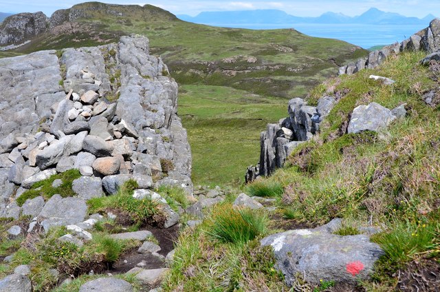
The hill is characterized by its rugged terrain and rocky slopes, making it a challenging but rewarding climb. It is covered in heather and grass, providing a picturesque setting with vibrant colors throughout the year. The summit of An Corrach offers panoramic vistas of the surrounding mountains, lochs, and glens, including the famous Loch Ness.

The hill is part of the Caledonian Forest, an ancient woodland that is home to a variety of plant and animal species, including red deer and golden eagles. The area is also known for its rich history, with evidence of human settlements dating back thousands of years.

Hiking to the top of An Corrach requires proper planning and preparation, as the weather conditions in the Highlands can be unpredictable, with strong winds and heavy rainfall. It is advisable to bring appropriate clothing, footwear, and navigation equipment.

Overall, An Corrach is a captivating destination for those seeking adventure and natural beauty. Its challenging ascent, stunning views, and connection to Scotland's history and wildlife make it a must-visit location in Inverness-shire.

If you have any feedback on the listing, please let us know in the comments section below.

An Corrach Images

Images are sourced within 2km of 56.88888/-6.1865712 or Grid Reference NM4585. Thanks to Geograph Open Source API. All images are credited.

The Sgurr overshadows the moors of Eigg
Eigg and Rum Eigg is in the foreground; the Sgurr is towards the left (west) end of the island. Beyond it is the island of Rum, and in the distance is Skye, with the Black Cuillin at extreme right.
Eigg and Rum
Eigg is in the foreground; the Sgurr is towards the left (west) end of the island. Beyond it is the island of Rum, and in the distance is Skye, with the Black Cuillin at extreme right.
The Nose, An Sgurr The striking summit that is actually the end of a steep-sided ridge of volcanic rock, looking much more impressive than its 394m height might suggest. The scale can be judged by the five figures on top.
The Nose, An Sgurr
The striking summit that is actually the end of a steep-sided ridge of volcanic rock, looking much more impressive than its 394m height might suggest. The scale can be judged by the five figures on top.
An Sgurr The striking profile of the ridge with wisps of cirrus above, seen from the NE from the path to the forestry plantation. The low sun picks out a terraced landform on the intervening ground.
An Sgurr
The striking profile of the ridge with wisps of cirrus above, seen from the NE from the path to the forestry plantation. The low sun picks out a terraced landform on the intervening ground.
Evening light on An Sgurr The dramatic rock ridge is catching the evening sunlight, seen here from near the Glebe Barn hostel.

See Anne Burgess's photograph <a href="https://www.geograph.org.uk/photo/3964613">NM4684 : The Nose</a> for an account of the geology of the Sgurr.
Evening light on An Sgurr
The dramatic rock ridge is catching the evening sunlight, seen here from near the Glebe Barn hostel. See Anne Burgess's photograph NM4684 : The Nose for an account of the geology of the Sgurr.
A closer view of The Nose, An Sgurr The 100m vertical prow of this volcanic ridge looms above the path around the north side.
A closer view of The Nose, An Sgurr
The 100m vertical prow of this volcanic ridge looms above the path around the north side.
Relay station below An Sgurr What looks to be a telephone repeater for a link to the north side of the island.
Relay station below An Sgurr
What looks to be a telephone repeater for a link to the north side of the island.
North side of An Sgurr The path, boggy in places, continues for about 1km before climbing to the ridge on easier ground.
North side of An Sgurr
The path, boggy in places, continues for about 1km before climbing to the ridge on easier ground.
North side of An Sgurr (2) Looking east from the path towards the steep profile of The Nose.
North side of An Sgurr (2)
Looking east from the path towards the steep profile of The Nose.
Moorland and lochan from An Sgurr As the path gains height, some of the lochans to the northwest come into view. Loch nam Ban Mora is in the middle distance with the mountains of Rum on the skyline. This scene is similar to that used on the cover of OS Explorer sheet 397.
Moorland and lochan from An Sgurr
As the path gains height, some of the lochans to the northwest come into view. Loch nam Ban Mora is in the middle distance with the mountains of Rum on the skyline. This scene is similar to that used on the cover of OS Explorer sheet 397.
Pitchstone on An Sgurr The columnar volcanic rock on this miniature mountain whose summit is Eigg's highest point.
Pitchstone on An Sgurr
The columnar volcanic rock on this miniature mountain whose summit is Eigg's highest point.
The ridge of An Sgurr Looking east towards the summit on the path that skirts the intermediate top to the right.
The ridge of An Sgurr
Looking east towards the summit on the path that skirts the intermediate top to the right.
Summit trig pillar, An Sgurr A fine day to enjoy the summit panorama from the highest point (393m) on Eigg. The Rum Cuillin are in the background.
Summit trig pillar, An Sgurr
A fine day to enjoy the summit panorama from the highest point (393m) on Eigg. The Rum Cuillin are in the background.
That's close enough, An Sgurr In the foreground is the edge of The Nose, promising a quick 100m vertical descent. Beyond is the pier and causeway at Galmisdale for the ferry to the mainland.
That's close enough, An Sgurr
In the foreground is the edge of The Nose, promising a quick 100m vertical descent. Beyond is the pier and causeway at Galmisdale for the ferry to the mainland.
Rum from An Sgurr, Eigg Looking across to the peaks of Rum, into Glen Dibidil with a ring of summits from Sgurr nan Gillean (L) round to Askival  and Hallival (R). The small lochan above centre is Lochan Caol na Cora-bheinne.
Rum from An Sgurr, Eigg
Looking across to the peaks of Rum, into Glen Dibidil with a ring of summits from Sgurr nan Gillean (L) round to Askival and Hallival (R). The small lochan above centre is Lochan Caol na Cora-bheinne.
The ridge of An Sgurr Looking west from below the summit to the intermediate top before the path descends to the north side.
The ridge of An Sgurr
Looking west from below the summit to the intermediate top before the path descends to the north side.
Path descending An Sgurr The route descends this little gap and descends diagonally rightwards. The red spot is a waymark.
Path descending An Sgurr
The route descends this little gap and descends diagonally rightwards. The red spot is a waymark.
Rustic bench by Loch nam Ban Mora We were surprised to find this wooden bench seat by the SE end of the loch - the 'Loch of the Big Women' according to the Eigg footpath guide. Local tradition holds that warrior women from Moidart murdered Saint Donan, and themselves were drowned in this loch.
Rustic bench by Loch nam Ban Mora
We were surprised to find this wooden bench seat by the SE end of the loch - the 'Loch of the Big Women' according to the Eigg footpath guide. Local tradition holds that warrior women from Moidart murdered Saint Donan, and themselves were drowned in this loch.
Show me another place!

An Corrach is located at Grid Ref: NM4585 (Lat: 56.88888, Lng: -6.1865712)

Unitary Authority: Highland

Police Authority: Highlands and Islands

What 3 Words

///arriving.extension.efficient. Near Arisaig, Highland

Related Wikis

An Sgùrr (Eigg)

An Sgùrr is the highest hill on the Inner Hebridean island of Eigg, Lochaber, Highland, Scotland. It was formed 58.72 ± 0.07 million years ago; the result...

Eigg

Eigg ( eg; Scottish Gaelic: Eige; Scots: Eigg) is one of the Small Isles in the Scottish Inner Hebrides. It lies to the south of the Isle of Skye and to...

Galmisdale

Galmisdale is the main port of the island of Eigg, one of the Small Isles of the Inner Hebrides. It is in the Scottish council area of Highland. ��2�...

Cleadale

Cleadale (Scottish Gaelic: Clèadail) is a settlement on the north west side of the island of Eigg, in the Small Isles of Scotland and is in the council...

Have you been to An Corrach?

Leave your review of An Corrach below (or comments, questions and feedback).