Cnoc Garabost

Hill, Mountain in Ross-shire

Scotland

Cnoc Garabost

Sheepfold at Tobha Mòr
Sheepfold at Tobha Mòr Credit: Sandy Gerrard

Cnoc Garabost, located in Ross-shire, Scotland, is a prominent hill/mountain that offers breathtaking scenic views and a rich natural environment. Rising to a height of approximately 875 meters (2,871 feet), it stands as an impressive landmark within the region.

The hill/mountain is situated in the northwest Scottish Highlands, near the picturesque village of Kinlochewe. Its location makes it easily accessible for hikers and outdoor enthusiasts looking to explore the surrounding area.

Cnoc Garabost is known for its rugged and rocky terrain, covered in heather and grasses. The hill/mountain provides a challenging but rewarding climb for experienced hikers, with various paths and trails leading to its summit. While the ascent can be demanding, the panoramic views from the top make it well worth the effort. On a clear day, visitors can enjoy stunning vistas of the surrounding mountains, lochs, and glens, immersing themselves in the untamed beauty of the Scottish Highlands.

In addition to its natural beauty, Cnoc Garabost is also home to a diverse range of flora and fauna. The hill/mountain supports a variety of plant species, including mosses, lichens, and wildflowers, adding to its ecological significance. Wildlife enthusiasts may spot red deer, mountain hares, and various bird species, creating opportunities for nature observation and photography.

Cnoc Garabost is a popular destination for outdoor activities such as hillwalking, hiking, and photography. Its striking landscape, coupled with its accessibility, makes it a must-visit location for those seeking an authentic Scottish Highland experience.

If you have any feedback on the listing, please let us know in the comments section below.

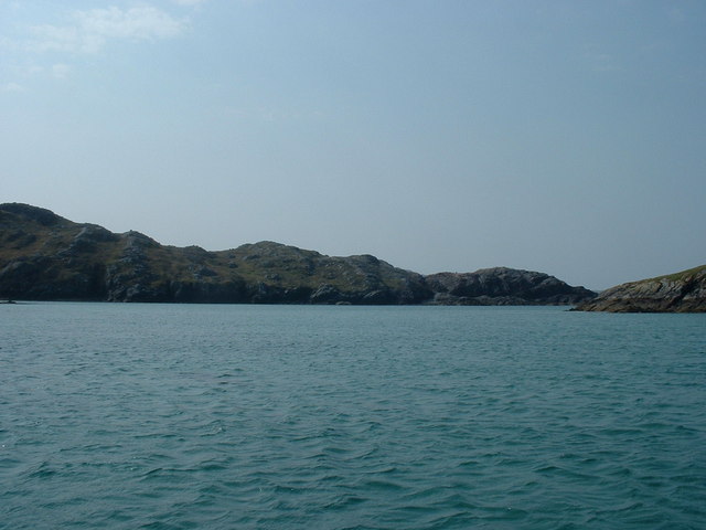
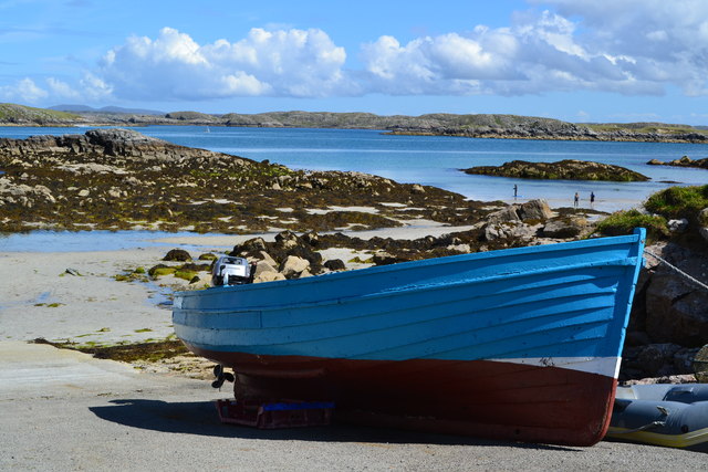
Cnoc Garabost Images

Images are sourced within 2km of 58.235864/-6.9479194 or Grid Reference NB0938. Thanks to Geograph Open Source API. All images are credited.

Sheepfold at Tobha Mòr
Sheepfold and boundary wall near Tobha Mòr
Rocky surface at Eala Sheadha
Eastern side of the Eala Sheadha Headland
Crystal clear seas off North West coast of Na h-Eileanan an Iar View to about 3 metres depth from RIB floating in lagoon between Pabaigh Mor and Pabaigh Beag.  See also <a href="https://www.geograph.org.uk/photo/1120209">NB1038 : Lagoon on Pabbay Mor</a>
Crystal clear seas off North West coast of Na h-Eileanan an Iar
View to about 3 metres depth from RIB floating in lagoon between Pabaigh Mor and Pabaigh Beag. See also NB1038 : Lagoon on Pabbay Mor
Sunrise, Gridig
Sunrise, Gridig
Beach at Pabaigh Mor
Geodh'an Tuill penetrates Pabaigh Mor Pabaigh More has a tidally flooded low-lying area in the middle of the island (at one time used for buffering lobsters) which connects to the open sea over a reef to the northwest, and through a couple of rocky channels heading northeast. It's clear that those channels must have started the same way as this cave, which has penetrated right to the lagoon (from which it is separated only by a storm beach thrown up by waves entering the cave) and, on a geological timescale, is just about at the end of its life. Although one of our group walked over the arch, and once we'd paddled round the island several of us entered the cave from the sea, it is not the most confidence-inspiring roof, especially at this landward end.
Geodh'an Tuill penetrates Pabaigh Mor
Pabaigh More has a tidally flooded low-lying area in the middle of the island (at one time used for buffering lobsters) which connects to the open sea over a reef to the northwest, and through a couple of rocky channels heading northeast. It's clear that those channels must have started the same way as this cave, which has penetrated right to the lagoon (from which it is separated only by a storm beach thrown up by waves entering the cave) and, on a geological timescale, is just about at the end of its life. Although one of our group walked over the arch, and once we'd paddled round the island several of us entered the cave from the sea, it is not the most confidence-inspiring roof, especially at this landward end.
Tràigh na Beirigh and Pabaigh Mòr
Traigh na Beirigh beach Lewis Looking out from the beach just in front of the Caravan site towards the headland at Kneep on the left and Pabaigh Mor on the right.
Traigh na Beirigh beach Lewis
Looking out from the beach just in front of the Caravan site towards the headland at Kneep on the left and Pabaigh Mor on the right.
Lagoon between Pabaigh Mor and Pabaigh Beag View to west showing narrows between these two islands off the northwest coast off Na h-Eileanan an Iar (Outer Hebrides).
Lagoon between Pabaigh Mor and Pabaigh Beag
View to west showing narrows between these two islands off the northwest coast off Na h-Eileanan an Iar (Outer Hebrides).
Bhaltos / Valtos Community of crofts, fishermen's houses and holiday homes on Pabbay Sound / Caolas Phabaigh.
Bhaltos / Valtos
Community of crofts, fishermen's houses and holiday homes on Pabbay Sound / Caolas Phabaigh.
Valtos Pier Sheltering the small harbour of Valtos / Bhaltos on Pabbay Sound / Caolas Phabaigh. The island of Pabaigh Mor / Big Pabbay is in the background.
Valtos Pier
Sheltering the small harbour of Valtos / Bhaltos on Pabbay Sound / Caolas Phabaigh. The island of Pabaigh Mor / Big Pabbay is in the background.
Machair Above Berie Sands Fertile grassland with summer flowers in bloom - with view across Traigh na Beirigh.
Machair Above Berie Sands
Fertile grassland with summer flowers in bloom - with view across Traigh na Beirigh.
View from near Bhaltos towards Pabaigh Mor
Traigh Bhaltos
Traigh Bhaltos
Blue boat on the slipway at Bhaltos
Fleeced! Fleeces hanging on fence of cottage at Bhaltos.
Fleeced!
Fleeces hanging on fence of cottage at Bhaltos.
Show me another place!

Cnoc Garabost is located at Grid Ref: NB0938 (Lat: 58.235864, Lng: -6.9479194)

Unitary Authority: Na h-Eileanan an Iar

Police Authority: Highlands and Islands

What 3 Words

///dusts.wells.ferried. Near Carloway, Na h-Eileanan Siar

Related Wikis

Pabaigh Mòr

Pabay Mòr or Pabaigh Mòr is an uninhabited island in the Outer Hebrides of Scotland. == History == The island's name comes from papey, an Old Norse name...

Kneep

Kneep (Scottish Gaelic: Cnìp) is a village on the Isle of Lewis, in the Outer Hebrides, Scotland. Kneep is within the parish of Uig.Various archaeological...

Vacsay

Vacsay (Scottish Gaelic: Bhacsaigh from Old Norse "bakkiey" meaning "peat bank island") is one of the Outer Hebrides. It is off the west coast of Lewis...

Cliff, Lewis

Cliff (Scottish Gaelic: Cliobh) is a small settlement on the Isle of Lewis, in the Outer Hebrides, Scotland. Cliff is within the parish of Uig. The settlement...

Have you been to Cnoc Garabost?

Leave your review of Cnoc Garabost below (or comments, questions and feedback).