Oireabhal

Hill, Mountain in Inverness-shire

Scotland

Oireabhal

Loch Chliostair dam, North Harris
Loch Chliostair dam, North Harris Credit: Alan Reid

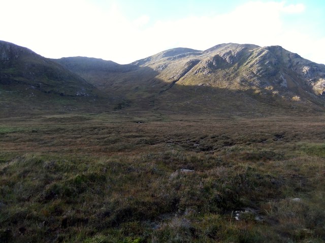
Oireabhal is a prominent hill located in Inverness-shire, a region in the Scottish Highlands. With an elevation of 662 meters (2,172 feet), it is considered a significant mountain in the area. The name "Oireabhal" is derived from the Gaelic language, meaning "eastern slope" or "parting ridge," aptly describing the geographical features of the hill.

Situated near the village of Lochcarron, Oireabhal offers stunning panoramic views of the surrounding landscape. From its summit, one can observe the picturesque Loch Carron, with its tranquil waters reflecting the beauty of the nearby mountains and forests. The hill itself boasts a rugged terrain, covered in heather and grasses, providing a home to various wildlife species such as red deer, mountain hares, and golden eagles.

Oireabhal is a popular destination among hikers and nature enthusiasts, offering a range of walking routes to suit different skill levels. The ascent to the summit can be challenging but rewarding, with breathtaking vistas awaiting those who conquer the hill. The trails meander through ancient woodlands, up steep slopes, and across rocky ridges, providing a diverse and exhilarating experience for outdoor enthusiasts.

In addition to its natural allure, Oireabhal holds historical and cultural significance. The hill is steeped in folklore and legends, with tales of ancient clans and mythical creatures. It serves as a reminder of the rich heritage and traditions of the Scottish Highlands.

Overall, Oireabhal stands as an impressive landmark in Inverness-shire, offering visitors a chance to immerse themselves in the untamed beauty of the Scottish landscape while connecting with its history and heritage.

If you have any feedback on the listing, please let us know in the comments section below.

Oireabhal Images

Images are sourced within 2km of 57.983051/-6.9352723 or Grid Reference NB0809. Thanks to Geograph Open Source API. All images are credited.

Loch Chliostair dam, North Harris
Trig Point on Cleiseabhal with view to Leosabhal & Tiorga Mor The walk to the summit of Cleiseabhal is surprisingly easy after leaving the B887 at NB065072 and making for the southwest ridge, however the first few hundred feet there is tussicky grass to cross.
Trig Point on Cleiseabhal with view to Leosabhal & Tiorga Mor
The walk to the summit of Cleiseabhal is surprisingly easy after leaving the B887 at NB065072 and making for the southwest ridge, however the first few hundred feet there is tussicky grass to cross.
Ridge leading northeast from Cleiseabhal This grassy ridge looks easy to walk but part way down, a rock band bisects the ridge which requires a short 'down scramble'.
Ridge leading northeast from Cleiseabhal
This grassy ridge looks easy to walk but part way down, a rock band bisects the ridge which requires a short 'down scramble'.
Rock band between Cleiseabhal & Bidigidh This rock band bisects the ridge and involves a short scramble.
Rock band between Cleiseabhal & Bidigidh
This rock band bisects the ridge and involves a short scramble.
Summit cairn on Oireabhal with view towards Ulabhal
Footbridge near Loch Chliostair The path leads to Gleann Uladail.
Footbridge near Loch Chliostair
The path leads to Gleann Uladail.
On the ridge north of Oireabhal with view towards Ulabhal
Rocky outcrop on ridge leading north towards Ulabhal
Cleft in rock and view down through Cathadail towards Sron Scourst
Summit cairn on Ulabhal
View north from Ulabhal towards Muladal The northern slope from Ulabhal is initially a boulder field.
View north from Ulabhal towards Muladal
The northern slope from Ulabhal is initially a boulder field.
Hillside towards Loch Chliostair
Glen Meavaig track This estate tracks runs past Loch Scourst and the towering crag of Sron Scourst to the end of the glen and more fishing lochs.
Glen Meavaig track
This estate tracks runs past Loch Scourst and the towering crag of Sron Scourst to the end of the glen and more fishing lochs.
Concreted ford in Glen Meavaig This concreted ford with tubes serves as a low bridge over the burn draining the corrie above. The 500m peak of Sron Scourst looms spectacularly in the background.
Concreted ford in Glen Meavaig
This concreted ford with tubes serves as a low bridge over the burn draining the corrie above. The 500m peak of Sron Scourst looms spectacularly in the background.
Sron Scourst and Gleann Mhiabhaig
In Gleann Miabhaig
In Gleann Miabhaig
Loch Chliostair Dam
Loch Chliostair Dam
Hillside below Cleiseabhal
Show me another place!

Oireabhal is located at Grid Ref: NB0809 (Lat: 57.983051, Lng: -6.9352723)

Unitary Authority: Na h-Eileanan an Iar

Police Authority: Highlands and Islands

What 3 Words

///candle.blankets.attending. Near Tarbert, Na h-Eileanan Siar

Nearby Locations

Bìdigidh Oireabhal

Related Wikis

Oireabhal

Oireabhal (662 m) is a mountain in Harris, in the Outer Hebrides of Scotland. The peak is the highest point on a complex ridge that runs from north to...

Chliostair Hydro-Electric Scheme

Chliostair Hydro-Electric Scheme is a small scheme promoted by the North of Scotland Hydro-Electric Board on Harris, Outer Hebrides. It consists of a single...

Tiorga Mor

Tiorga Mor (679 m) is a mountain in Harris, in the Outer Hebrides of Scotland. The most westerly peak of the high mountains of Harris, it is a very rugged...

Uladail

Uladail is a location near Amhuinnsuidhe, on Harris in the Outer Hebrides, Scotland. Sron Ulladail is a sheer cliff which at 370 metres (1,210 ft) is one...

Nearby Amenities

Located within 500m of 57.983051,-6.9352723
Oireabhal
Alt Name: Oireabhal
Corbett: no
Ele: 662
Graham: yes
Marilyn: yes
Munro: no
Name En: Oreval
Name Gd: Oireabhal
Natural: peak
Prominence: 419
Source: OS_OpenData_StreetView
Lat/Long: 57.9833549/-6.9351198
The data included in this document is from www.openstreetmap.org. The data is made available under ODbL.

Have you been to Oireabhal?

Leave your review of Oireabhal below (or comments, questions and feedback).