Henley

Settlement in Shropshire

England

Henley

New supermarket development (Ludlow) Looks like the new Sainsbury's supermarket is expanding, and this is placed at the junction of the A49 and A4117 roads. This may open to the public during November 2021.
New supermarket development (Ludlow) Credit: Fabian Musto

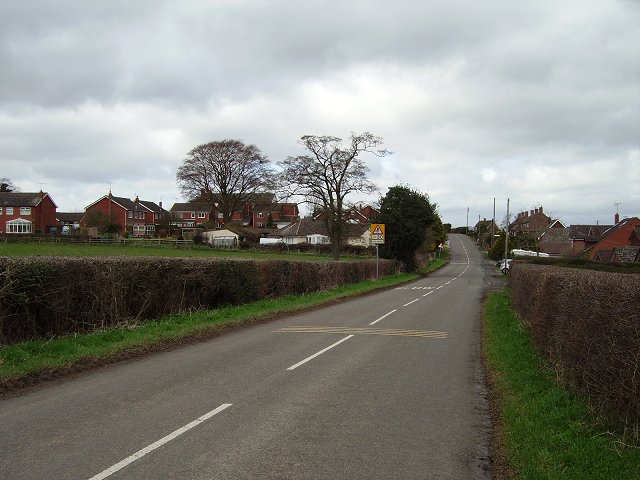
Henley is a small village located in the county of Shropshire, England. Situated in the West Midlands region, it lies approximately three miles northeast of the town of Ludlow. The village is nestled in the picturesque countryside, surrounded by rolling hills and lush green fields, offering stunning views and a tranquil atmosphere.

Henley has a long and rich history, with evidence of human settlement in the area dating back to prehistoric times. The village grew during the medieval period and became an important trading center, benefiting from its strategic location on the ancient road between Ludlow and Bridgnorth.

Today, Henley retains much of its traditional charm, with a mix of old and new buildings lining its narrow streets. The village is home to a close-knit community, and residents enjoy a peaceful rural lifestyle. Amenities in Henley include a local pub, a village hall, and a primary school, ensuring the basic needs of the community are met.

The surrounding countryside provides ample opportunities for outdoor activities, such as hiking, cycling, and horse riding. The nearby Mortimer Forest is a popular spot for nature enthusiasts, offering scenic walking trails and panoramic views over the Shropshire Hills.

With its idyllic setting and historical significance, Henley is a place that appeals to those seeking a peaceful retreat in the heart of the English countryside.

If you have any feedback on the listing, please let us know in the comments section below.

Henley Images

Images are sourced within 2km of 52.382409/-2.675653 or Grid Reference SO5476. Thanks to Geograph Open Source API. All images are credited.

New supermarket development (Ludlow) Looks like the new Sainsbury's supermarket is expanding, and this is placed at the junction of the A49 and A4117 roads. This may open to the public during November 2021.
New supermarket development (Ludlow)
Looks like the new Sainsbury's supermarket is expanding, and this is placed at the junction of the A49 and A4117 roads. This may open to the public during November 2021.
Sainsbury's Rock Green Newly opened (30/11/21) and outside the Ludlow bypass.
Sainsbury's Rock Green
Newly opened (30/11/21) and outside the Ludlow bypass.
Car park: Sainsbury's, Rock Green
Rock Green roundabout, A49 Henley Road meets the A49.
Rock Green roundabout, A49
Henley Road meets the A49.
Bee hotel, Sainsbury's In the car park.
Bee hotel, Sainsbury's
In the car park.
Crossing Dun Cow Road By the new supermarket.
Crossing Dun Cow Road
By the new supermarket.
Dun Cow Road Way out from the new supermarket.
Dun Cow Road
Way out from the new supermarket.
Rocksgreen Crescent and Dun Cow Road Ludlow jumped the bypass a few years back, here and up at Sheet Road. The houses predate the supermarket which had been open for a month at the time this was taken
Rocksgreen Crescent and Dun Cow Road
Ludlow jumped the bypass a few years back, here and up at Sheet Road. The houses predate the supermarket which had been open for a month at the time this was taken
Fields, Rock Green For how much longer?
Fields, Rock Green
For how much longer?
Wigley and anaerobic digesters
Footpath Footpath running from Downton View down to the Ludlow bypass, following the route of footpath that pre-existed the development of the area.  It has now taken extra significance since the opening of a new Sainsbury's supermarket at Rocks Green in November 2021, near the foot of this path.
Footpath
Footpath running from Downton View down to the Ludlow bypass, following the route of footpath that pre-existed the development of the area. It has now taken extra significance since the opening of a new Sainsbury's supermarket at Rocks Green in November 2021, near the foot of this path.
Sainsbury's, Rock Green Sainsbury's supermarket at Rock Green, sited at the junction of the A4117 and the A49 Ludlow bypass, opened on 30 November 2021.
Sainsbury's, Rock Green
Sainsbury's supermarket at Rock Green, sited at the junction of the A4117 and the A49 Ludlow bypass, opened on 30 November 2021.
Knights Way Part completed development at Rock Green.
Knights Way
Part completed development at Rock Green.
Knights Way Part completed development at Rock Green.
Knights Way
Part completed development at Rock Green.
Show me another place!

Henley is located at Grid Ref: SO5476 (Lat: 52.382409, Lng: -2.675653)

Unitary Authority: Shropshire

Police Authority: West Mercia

What 3 Words

///trudges.trembles.expand. Near Ludlow, Shropshire

Nearby Locations

Henley The Orchard

Related Wikis

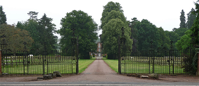
Henley Hall, Shropshire

Henley Hall is a building of historical significance and is listed on the English Heritage Register. It was built in about 1610 by the Powys family and...

Middleton, Bitterley

Middleton is a small village in south Shropshire, England. It is located 2.5 miles (4.0 km) northeast of Ludlow town centre, on the B4364 road (which runs...

Ledwyche Brook

Ledwyche Brook is a minor river in south Shropshire, England. It is sometimes referred to as the River Ledwyche and spelled variously, including "Ledwich...

Sheet, Shropshire

Sheet (or "The Sheet") is a small modern village in the parish of Ludford about 1 mile (1.6 km) from the town centre of Ludlow, Shropshire. It was mentioned...

Nearby Amenities

Located within 500m of 52.382409,-2.675653
Henley
Place: hamlet
Source: OS_OpenData_StreetView
Lat/Long: 52.3832291/-2.675137
The data included in this document is from www.openstreetmap.org. The data is made available under ODbL.

Have you been to Henley?

Leave your review of Henley below (or comments, questions and feedback).