Sleiteabhal

Hill, Mountain in Inverness-shire

Scotland

Sleiteabhal

Rock shelter, Gleann Uamh nam Ban, Harris From <span class="nowrap"><a title="https://canmore.org.uk/site/346809/gleann-uamh-nam-ban" rel="nofollow ugc noopener" href="https://canmore.org.uk/site/346809/gleann-uamh-nam-ban">Link</a><img style="margin-left:2px;" alt="External link" title="External link - shift click to open in new window" src="https://s1.geograph.org.uk/img/external.png" width="10" height="10"/></span> : "... a rock shelter was observed on the right side of Gleann Uamh nam Ban (Cave of the Women) which would appear to be the site the Gleann is named after. The site shows some remains of use and local tradition has a Norse association to it. The site is probably early medieval."
Rock shelter, Gleann Uamh nam Ban, Harris Credit: Claire Pegrum

Sleiteabhal is a prominent hill located in Inverness-shire, Scotland. It lies within the wider region of the Scottish Highlands, renowned for its stunning natural landscapes. With an elevation of approximately 764 meters (2,507 feet), Sleiteabhal offers breathtaking panoramic views of the surrounding area.

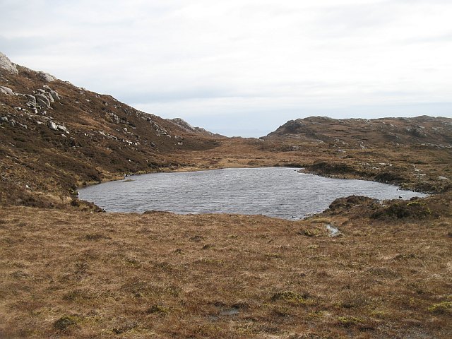
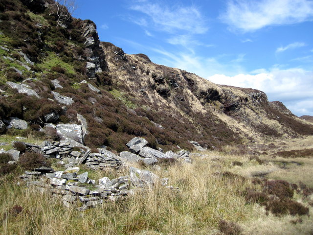
This mountain is situated in a remote and rugged terrain, characterized by its rocky slopes and heather-covered moorland. Its location, far away from any major settlements, adds to its sense of tranquility and untouched beauty. Sleiteabhal is part of a larger range known as the Western Isles, which is home to several other peaks and hills.

Access to Sleiteabhal is possible via various hiking trails that cater to different levels of expertise. The ascent can be challenging due to the steep gradient and uneven terrain, but it rewards climbers with spectacular vistas of the surrounding mountains, lochs, and glens. On a clear day, one can even catch a glimpse of the distant Isle of Skye.

The hill is also notable for its rich biodiversity. It is home to a variety of flora and fauna, including heather, Bilberry, and the elusive golden eagle. In addition, the area surrounding Sleiteabhal is dotted with sparkling lochs and meandering rivers, adding to its natural beauty.

Sleiteabhal offers outdoor enthusiasts a wonderful opportunity to immerse themselves in the rugged and captivating landscapes of the Scottish Highlands. Whether one is an avid hiker or simply seeking a place of solitude and natural beauty, Sleiteabhal is a destination that is sure to captivate and inspire.

If you have any feedback on the listing, please let us know in the comments section below.

Sleiteabhal Images

Images are sourced within 2km of 57.818112/-6.9690048 or Grid Reference NG0591. Thanks to Geograph Open Source API. All images are credited.

Rock shelter, Gleann Uamh nam Ban, Harris From <span class="nowrap"><a title="https://canmore.org.uk/site/346809/gleann-uamh-nam-ban" rel="nofollow ugc noopener" href="https://canmore.org.uk/site/346809/gleann-uamh-nam-ban">Link</a><img style="margin-left:2px;" alt="External link" title="External link - shift click to open in new window" src="https://s1.geograph.org.uk/img/external.png" width="10" height="10"/></span> : "... a rock shelter was observed on the right side of Gleann Uamh nam Ban (Cave of the Women) which would appear to be the site the Gleann is named after. The site shows some remains of use and local tradition has a Norse association to it. The site is probably early medieval."
Rock shelter, Gleann Uamh nam Ban, Harris
From LinkExternal link : "... a rock shelter was observed on the right side of Gleann Uamh nam Ban (Cave of the Women) which would appear to be the site the Gleann is named after. The site shows some remains of use and local tradition has a Norse association to it. The site is probably early medieval."
Course of the Allt Dritil, Harris
Loch na h-Uamha, Harris The large loch behind is Loch Langabhat. The high ground on the left is Bhoiseabhal and coming down from the right is Bleabhal.
Loch na h-Uamha, Harris
The large loch behind is Loch Langabhat. The high ground on the left is Bhoiseabhal and coming down from the right is Bleabhal.
Ruined building below Sleiteabhal, Harris Looking towards Bleabhal.
Ruined building below Sleiteabhal, Harris
Looking towards Bleabhal.
Loch below Sleiteabhal, Harris Approximately 40% of the length of the loch lies within the grid square.
Loch below Sleiteabhal, Harris
Approximately 40% of the length of the loch lies within the grid square.
Loch Loch Langabhat, Harris Looking towards Bleabhal.
Loch Loch Langabhat, Harris
Looking towards Bleabhal.
Dyke by the Allt a' Choire, Harris The distinctive wiggly line of the dyke is shown on OS maps with a scale of 1:25,000 and larger.
Dyke by the Allt a' Choire, Harris
The distinctive wiggly line of the dyke is shown on OS maps with a scale of 1:25,000 and larger.
Lochan on moorland below Bulabhall, Harris
Boggy pools on the eastern slopes of Bleabhal, Harris Looking towards Roineabhal, the highest point in south Harris.
Boggy pools on the eastern slopes of Bleabhal, Harris
Looking towards Roineabhal, the highest point in south Harris.
Moorland pool to the east of Loch Langabhat, Harris Looking towards Loch Dubh Shleiteabhal, which is the name on the OS 1:50,000 map.  On the 1:25,000 map it is called Loch Dubh Màs Shlèiteabhal.
Moorland pool to the east of Loch Langabhat, Harris
Looking towards Loch Dubh Shleiteabhal, which is the name on the OS 1:50,000 map. On the 1:25,000 map it is called Loch Dubh Màs Shlèiteabhal.
Loch Dubh Mas Holasmul
Bleabhal trig point The trig point on Bleabhal.
Bleabhal trig point
The trig point on Bleabhal.
Lochans, South Harris A string of lochans south of Bulabhall. The islands of the Sound of Harris and North Uist in the background.
Lochans, South Harris
A string of lochans south of Bulabhall. The islands of the Sound of Harris and North Uist in the background.
Lochan, Bealach an Ionalaidh Lochan near the head of the pass.
Lochan, Bealach an Ionalaidh
Lochan near the head of the pass.
Lochan, Bulabhall One of many small lochans amongst the gneiss slabs. View of Oireabhal in North Harris.
Lochan, Bulabhall
One of many small lochans amongst the gneiss slabs. View of Oireabhal in North Harris.
Rock formation, Bulabhal Gives the impression of being a dyke. The brown rock contrasts with the light grey gneiss in the area.
Rock formation, Bulabhal
Gives the impression of being a dyke. The brown rock contrasts with the light grey gneiss in the area.
Loch Langabhat and Sleiteabhal Taken from below the summit of Bhoiseabhal. View along the Western flank of Mas Garbh to the Northern part of Loch Langabhat. Directly behind it rises Sleiteabhal, and a bit further on Bulabhall. In the distance, West Loch Tarbert can be vaguely discerned. The Lochan East of Loch Langabhat is Loch Dubh Mas Shleiteabhal.
Loch Langabhat and Sleiteabhal
Taken from below the summit of Bhoiseabhal. View along the Western flank of Mas Garbh to the Northern part of Loch Langabhat. Directly behind it rises Sleiteabhal, and a bit further on Bulabhall. In the distance, West Loch Tarbert can be vaguely discerned. The Lochan East of Loch Langabhat is Loch Dubh Mas Shleiteabhal.
Sheiling below Sleitabhal Ruins of a shieling on the eastern flank of Sleitabhal - unmarked on all OS maps
Sheiling below Sleitabhal
Ruins of a shieling on the eastern flank of Sleitabhal - unmarked on all OS maps
Show me another place!

Sleiteabhal is located at Grid Ref: NG0591 (Lat: 57.818112, Lng: -6.9690048)

Unitary Authority: Na h-Eileanan an Iar

Police Authority: Highlands and Islands

What 3 Words

///interacts.bedrock.moisture. Near Leverburgh, Na h-Eileanan Siar

Nearby Locations

Harris Sleiteabhal

Related Wikis

Borve, Harris

Borve (Scottish Gaelic: Na Buirgh) is a village in Harris in the Outer Hebrides, Scotland. Borve is also within the parish of Harris, and is on the A859...

1990 Scotland RAF Shackleton crash

On 30 April 1990, a Royal Air Force Avro Shackleton AEW Mk II aircraft, of No. 8 Squadron RAF, based at RAF Lossiemouth, crashed into a hill on the Isle...

Roineabhal

Roineabhal is a hill in Harris, in the Western Isles of Scotland. The granite on the summit plateau of the mountain is anorthosite, and is similar in composition...

Leverburgh

Leverburgh (Scottish Gaelic: An t-Òb [ən̪ˠ ˈt̪ɔːp]) is the second largest village, after Tarbert, in Harris in the Outer Hebrides of Scotland. Leverburgh...

Nearby Amenities

Located within 500m of 57.818112,-6.9690048
Sleiteabhal
Alt Name: Sleteval
Ele: 224
Natural: peak
Lat/Long: 57.8177123/-6.967925
The data included in this document is from www.openstreetmap.org. The data is made available under ODbL.

Have you been to Sleiteabhal?

Leave your review of Sleiteabhal below (or comments, questions and feedback).