Town Green

Downs, Moorland in Norfolk Breckland

England

Town Green

Great Ellingham: Houses in Poppy Way
Great Ellingham: Houses in Poppy Way Credit: Michael Garlick

Town Green, Norfolk (Downs, Moorland) is a picturesque and charming village located in the heart of Norfolk, England. Situated amidst rolling green hills and expansive moorlands, it offers a serene and idyllic setting for residents and visitors alike. With a population of approximately 1,500 people, it maintains a close-knit and friendly community atmosphere.

The village is characterized by its traditional English architecture, with charming cottages and historic buildings lining the streets. The center of Town Green is adorned with a village green, a well-maintained open space where locals gather for recreational activities and community events throughout the year.

Surrounded by stunning natural beauty, the Downs and Moorland areas provide ample opportunities for outdoor enthusiasts. The Downs, situated to the south of Town Green, is a series of rolling hills covered in lush green grass and dotted with grazing sheep. It offers breathtaking views of the surrounding countryside and is a popular spot for hiking, picnicking, and enjoying the peacefulness of nature.

To the north of the village lies the Moorland, a vast expanse of open and wild land. This area is known for its unique flora and fauna, including rare bird species and a variety of wildflowers. It is a paradise for nature lovers, birdwatchers, and photographers.

Town Green is also home to a number of amenities, including a village hall, a primary school, and a local pub. It benefits from excellent transport links, with regular bus services connecting it to nearby towns and cities.

Overall, Town Green, Norfolk (Downs, Moorland) is a tranquil and scenic village that offers a peaceful retreat from the hustle and bustle of modern life. With its stunning natural landscapes and friendly community, it is a hidden gem in the heart of Norfolk.

If you have any feedback on the listing, please let us know in the comments section below.

Town Green Images

Images are sourced within 2km of 52.531369/0.97246565 or Grid Reference TM0196. Thanks to Geograph Open Source API. All images are credited.

Great Ellingham: Houses in Poppy Way
Industrial shed by Bush Green
Industrial shed east of Hingham Road, Bush Green
View along the northern edge of a spectacle dispersal One of several which have remained intact, this aircraft dispersal is situated west of Bush Green Farm and used for farm storage.
View along the northern edge of a spectacle dispersal
One of several which have remained intact, this aircraft dispersal is situated west of Bush Green Farm and used for farm storage.
Fields at Bush Green This view was taken from the spectacle dispersal near Bush Green Farm.  Many of the concrete hardstandings remain in place and are now used for storage by the farmers.
Fields at Bush Green
This view was taken from the spectacle dispersal near Bush Green Farm. Many of the concrete hardstandings remain in place and are now used for storage by the farmers.
Ripening barley by Bush Green Farm This view was taken from the spectacle dispersal near Bush Green Farm. Many of the concrete hardstandings remain in place and are now used for storage by the farmers.
Ripening barley by Bush Green Farm
This view was taken from the spectacle dispersal near Bush Green Farm. Many of the concrete hardstandings remain in place and are now used for storage by the farmers.
View along the eastern edge of a spectacle dispersal This view was taken from the spectacle dispersal near Bush Green Farm. Many of the concrete hardstandings remain in place and are now used for storage by the farmers.
View along the eastern edge of a spectacle dispersal
This view was taken from the spectacle dispersal near Bush Green Farm. Many of the concrete hardstandings remain in place and are now used for storage by the farmers.
Sentry hut beside track The hut stands beside a track which connected accommodation huts > <a title="https://www.geograph.org.uk/photo/4096168" href="https://www.geograph.org.uk/photo/4096168">Link</a> with a spectacle aircraft dispersal when RAF Deopham Green was an active airfield during WW2.
Sentry hut beside track
The hut stands beside a track which connected accommodation huts > Link with a spectacle aircraft dispersal when RAF Deopham Green was an active airfield during WW2.
RAF buildings beside the road A prefabricated concrete building can be seen adjoining the overgrown Nissen hut which would have provided accommodation for the ground crew which serviced aircraft on the dispersals by day and night and in all weather. A sentry hut > <a title="https://www.geograph.org.uk/photo/4096162" href="https://www.geograph.org.uk/photo/4096162">Link</a> still stands beside a track across the road from here. The track leads to a spectacle dispersal, now used for farm storage but used for parking aircraft when RAF Deopham Green was an active airfield during WW2.
RAF buildings beside the road
A prefabricated concrete building can be seen adjoining the overgrown Nissen hut which would have provided accommodation for the ground crew which serviced aircraft on the dispersals by day and night and in all weather. A sentry hut > Link still stands beside a track across the road from here. The track leads to a spectacle dispersal, now used for farm storage but used for parking aircraft when RAF Deopham Green was an active airfield during WW2.
Old Nissen hut beside the road A prefabricated concrete building can be seen adjoining the overgrown Nissen hut which would have provided accommodation for the ground crew which serviced aircraft on the dispersals by day and night and in all weather. A sentry hut > <a title="https://www.geograph.org.uk/photo/4096162" href="https://www.geograph.org.uk/photo/4096162">Link</a> still stands beside a track across the road from here. The track leads to a spectacle dispersal, now used for farm storage but used for parking aircraft when RAF Deopham Green was an active airfield during WW2.
Old Nissen hut beside the road
A prefabricated concrete building can be seen adjoining the overgrown Nissen hut which would have provided accommodation for the ground crew which serviced aircraft on the dispersals by day and night and in all weather. A sentry hut > Link still stands beside a track across the road from here. The track leads to a spectacle dispersal, now used for farm storage but used for parking aircraft when RAF Deopham Green was an active airfield during WW2.
Stubble field on the old airfield The minor road here follows a section of the former southern perimeter track.
Stubble field on the old airfield
The minor road here follows a section of the former southern perimeter track.
View across Deopham Green airfield This WW2 airfield has long since returned to agriculture.
View across Deopham Green airfield
This WW2 airfield has long since returned to agriculture.
Old concreted road It used to be part of the perimeter track, leading to the spectacle dispersal by Bush Green Farm, and is now used for farm storage.
Old concreted road
It used to be part of the perimeter track, leading to the spectacle dispersal by Bush Green Farm, and is now used for farm storage.
View towards Stalland Common Although it looks like one, the long building seen in the background is not a RAF building but formed part of the former Council depot located here after WW2.
View towards Stalland Common
Although it looks like one, the long building seen in the background is not a RAF building but formed part of the former Council depot located here after WW2.
Large shed at Stalland Common This area was part of the former Technical site of RAF Deopham Green but despite the building appearing to be standing in the footprint of one of the RAF buildings it was built after the war and has nothing to do with the airfield.
Large shed at Stalland Common
This area was part of the former Technical site of RAF Deopham Green but despite the building appearing to be standing in the footprint of one of the RAF buildings it was built after the war and has nothing to do with the airfield.
Track into the Sub-ordnance depot site This concreted road leads into the former depot site which formed part of RAF Deopham Green when it was an active airfield during WW2.
Track into the Sub-ordnance depot site
This concreted road leads into the former depot site which formed part of RAF Deopham Green when it was an active airfield during WW2.
Overgrown RAF building This would seem to be the only building surviving on the former depot site which formed part of RAF Deopham Green when it was an active airfield during WW2.
Overgrown RAF building
This would seem to be the only building surviving on the former depot site which formed part of RAF Deopham Green when it was an active airfield during WW2.
Old RAF building It is situated on the edge of a hardstanding which formed part of Site 7, one of the dispersed sites associated with RAF Deopham Green when it was an active airfield during WW2 - one of only a few buildings that would seem to have survived on this site.
Old RAF building
It is situated on the edge of a hardstanding which formed part of Site 7, one of the dispersed sites associated with RAF Deopham Green when it was an active airfield during WW2 - one of only a few buildings that would seem to have survived on this site.
Show me another place!

Town Green is located at Grid Ref: TM0196 (Lat: 52.531369, Lng: 0.97246565)

Administrative County: Norfolk

District: Breckland

Police Authority: Norfolk

What 3 Words

///shadowing.dribble.jigging. Near Attleborough, Norfolk

Related Wikis

Great Ellingham Windmill

Great Ellingham Windmill is a Grade II listed tower mill in Great Ellingham, Norfolk, England which has been converted to residential accommodation....

Great Ellingham

Great Ellingham is a village and civil parish in the Breckland District of Norfolk. The village lies 2.5 miles north-west of Attleborough, 2 miles south...

Anchor Corner

Anchor Corner is a village in Norfolk, England.
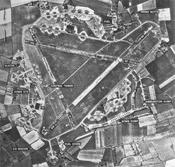
RAF Deopham Green

Royal Air Force Deopham Green or more simply RAF Deopham Green is a former Royal Air Force station located near Deopham Green 2 miles (3.2 km) north of...

Little Ellingham

Little Ellingham is a village and civil parish in the English county of Norfolk. The village is 4.6 miles (7.4 km) north-west of Attleborough, 2 miles...

Rockland St Peter

Rockland St Peter is a village and former civil parish, now in the parish of Rocklands, in the Breckland district, in the county of Norfolk, England. Its...

Rockland All Saints

Rockland All Saints is a village and former civil parish, now in the parish of Rocklands, in the Breckland district, in the county of Norfolk, England...

Attleborough Academy

Attleborough Academy/Attleborough Academy Norfolk (AA/AAN) (formerly Attleborough High School) is a coeducational secondary school and sixth form with...

Nearby Amenities

Located within 500m of 52.531369,0.97246565
Post Office
Great Ellingham Village Stores & Post Office
Addr City: Attleborough
Addr Housenumber: 1
Addr Postcode: NR17 1LL
Addr Street: Long Street
Addr Village: Great Ellingham
Fhrs Id: 606458
Opening Hours Post Office: Mo,Tu,Th,Fr 09:00-13:00,14:00-17:30; We,Sa 09:00-13:00
Ref Pol Id: 1340
Shop: convenience
Source Addr: FSA Food Hygiene Ratings Database
Source Opening Hours Post Office: pol_branch_list_2018-01
Lat/Long: 52.5327701/0.9738597
Post Box
Collection Times: Mo-Fr 17:00; Sa 10:15
Post Box Design: type_b
Post Box Type: pillar
Ref: NR17 1720
Royal Cypher: EIIR
Royal Cypher Wikidata: Q33102113
Lat/Long: 52.5328418/0.973904
Disused: yes
Man Made: windmill
Windmill Vanes: no
Lat/Long: 52.5324924/0.9742552
Waste Basket
Waste: dog_excrement
Lat/Long: 52.5312444/0.9729366
Mill Farm
Phone: +44 1953452769
Tourism: caravan_site
Lat/Long: 52.532721/0.975652
Leisure: picnic_table
Lat/Long: 52.5322189/0.9726491
Entrance: yes
Lat/Long: 52.5347153/0.9773702
Defibrillator
Defibrillator Location: Exterior wall of Great Ellingham Methodist Church, facing Church Street.
Emergency: defibrillator
Ref GB The Circuit: 8821C999-CC9F-415A-AEF9-AE9E00E05A9C
Lat/Long: 52.5338239/0.9764079
Bench
Lat/Long: 52.533622/0.9757847
The data included in this document is from www.openstreetmap.org. The data is made available under ODbL.

Have you been to Town Green?

Leave your review of Town Green below (or comments, questions and feedback).