East Wretham Heath

Downs, Moorland in Norfolk Breckland

England

East Wretham Heath

Marker pole on the Peddars Way The Peddars Way is a long distance footpath in Norfolk. It is 46 miles long and follows the route of a Roman road. It has been suggested by more than one writer that it was not created by the Romans but was an ancient trackway, a branch or extension of the Icknield Way, used and remodelled by the Romans. The name is said to be derived from the Latin pedester – on foot.  It starts at Knettishall Heath in Suffolk (near the Norfolk-Suffolk border, about 4 miles east of Thetford), and it links with the Norfolk Coast Path at Holme-next-the-Sea.
Combined with the Norfolk Coast Path, it forms the Peddars Way & Norfolk Coast Path National Trail, one of 15 National Trails in England and Wales, and the two paths together run for 97 miles.
Wikipedia: <span class="nowrap"><a title="http://en.wikipedia.org/wiki/Peddars_Way" rel="nofollow ugc noopener" href="http://en.wikipedia.org/wiki/Peddars_Way">Link</a><img style="margin-left:2px;" alt="External link" title="External link - shift click to open in new window" src="https://s1.geograph.org.uk/img/external.png" width="10" height="10"/></span>
Marker pole on the Peddars Way Credit: Basher Eyre

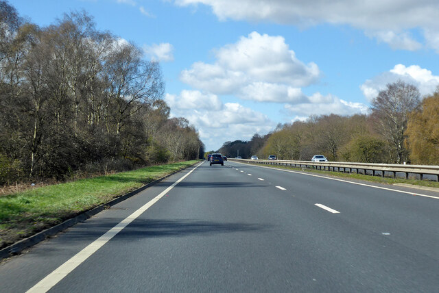
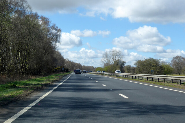
East Wretham Heath, located in Norfolk, England, is a diverse and ecologically important area known for its downs and moorland. Covering approximately 250 hectares, it is a protected nature reserve managed by the Norfolk Wildlife Trust. The heath is situated on sandy soils, which contribute to its unique habitat and rich biodiversity.

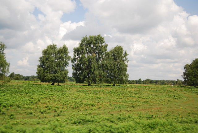
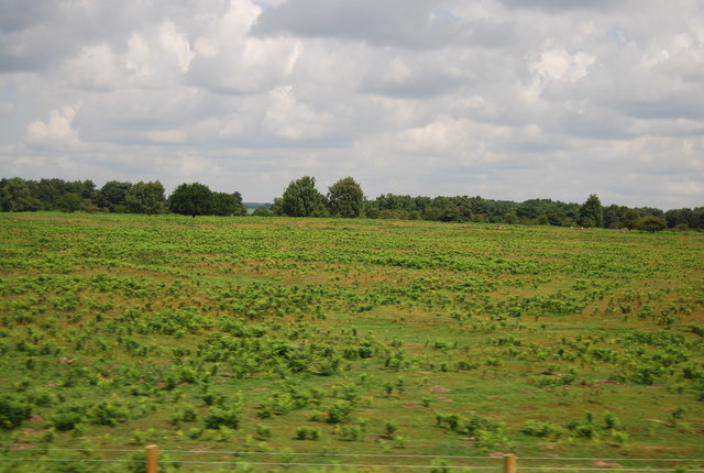
The landscape of East Wretham Heath is characterized by undulating slopes, open grassland, and heather-covered areas. The downs consist of gently rolling hills with sparse vegetation, while the moorland features a mix of heather, gorse, and bracken. These habitats provide a haven for a wide range of plant and animal species.

The reserve is home to several rare and threatened species, including the stone curlew, a ground-nesting bird that is a symbol of the heath. Other bird species that can be spotted here include the nightjar, woodlark, and Dartford warbler. The area also supports a diverse array of insects, reptiles, and small mammals.

In addition to its ecological significance, East Wretham Heath has historical importance. It was once used as a training ground for military exercises during World War II, and remnants of wartime structures can still be seen today.

Visitors to East Wretham Heath can explore the reserve through a network of well-maintained footpaths and trails. The Norfolk Wildlife Trust provides information boards and guided walks to help educate visitors about the unique flora and fauna found in the area. With its stunning landscapes and abundant wildlife, East Wretham Heath offers a captivating experience for nature enthusiasts and history buffs alike.

If you have any feedback on the listing, please let us know in the comments section below.

East Wretham Heath Images

Images are sourced within 2km of 52.457665/0.81621831 or Grid Reference TL9188. Thanks to Geograph Open Source API. All images are credited.

Marker pole on the Peddars Way The Peddars Way is a long distance footpath in Norfolk. It is 46 miles long and follows the route of a Roman road. It has been suggested by more than one writer that it was not created by the Romans but was an ancient trackway, a branch or extension of the Icknield Way, used and remodelled by the Romans. The name is said to be derived from the Latin pedester – on foot.  It starts at Knettishall Heath in Suffolk (near the Norfolk-Suffolk border, about 4 miles east of Thetford), and it links with the Norfolk Coast Path at Holme-next-the-Sea.
Combined with the Norfolk Coast Path, it forms the Peddars Way & Norfolk Coast Path National Trail, one of 15 National Trails in England and Wales, and the two paths together run for 97 miles.
Wikipedia: <span class="nowrap"><a title="http://en.wikipedia.org/wiki/Peddars_Way" rel="nofollow ugc noopener" href="http://en.wikipedia.org/wiki/Peddars_Way">Link</a><img style="margin-left:2px;" alt="External link" title="External link - shift click to open in new window" src="https://s1.geograph.org.uk/img/external.png" width="10" height="10"/></span>
Marker pole on the Peddars Way
The Peddars Way is a long distance footpath in Norfolk. It is 46 miles long and follows the route of a Roman road. It has been suggested by more than one writer that it was not created by the Romans but was an ancient trackway, a branch or extension of the Icknield Way, used and remodelled by the Romans. The name is said to be derived from the Latin pedester – on foot. It starts at Knettishall Heath in Suffolk (near the Norfolk-Suffolk border, about 4 miles east of Thetford), and it links with the Norfolk Coast Path at Holme-next-the-Sea. Combined with the Norfolk Coast Path, it forms the Peddars Way & Norfolk Coast Path National Trail, one of 15 National Trails in England and Wales, and the two paths together run for 97 miles. Wikipedia: LinkExternal link
Fallen log within Roudham Heath (on the Peddars Way)
Fallen log within Roudham Heath
(on the Peddars Way)
Spindly trees within Roudham Heath (taken from the Peddars Way)
Spindly trees within Roudham Heath
(taken from the Peddars Way)
Van heading towards Roudham Gas Station (taken on the Peddars Way)
Van heading towards Roudham Gas Station
(taken on the Peddars Way)
Looking towards Roudham Heath Gas Pressure Reduction Station (which is on the Peddars Way)
Looking towards Roudham Heath Gas Pressure Reduction Station
(which is on the Peddars Way)
Path branching off from the Peddars Way The Peddars Way is a long distance footpath in Norfolk. It is 46 miles long and follows the route of a Roman road. It has been suggested by more than one writer that it was not created by the Romans but was an ancient trackway, a branch or extension of the Icknield Way, used and remodelled by the Romans. The name is said to be derived from the Latin pedester – on foot.  It starts at Knettishall Heath in Suffolk (near the Norfolk-Suffolk border, about 4 miles east of Thetford), and it links with the Norfolk Coast Path at Holme-next-the-Sea.
Combined with the Norfolk Coast Path, it forms the Peddars Way & Norfolk Coast Path National Trail, one of 15 National Trails in England and Wales, and the two paths together run for 97 miles.
Wikipedia: <span class="nowrap"><a title="http://en.wikipedia.org/wiki/Peddars_Way" rel="nofollow ugc noopener" href="http://en.wikipedia.org/wiki/Peddars_Way">Link</a><img style="margin-left:2px;" alt="External link" title="External link - shift click to open in new window" src="https://s1.geograph.org.uk/img/external.png" width="10" height="10"/></span>
Path branching off from the Peddars Way
The Peddars Way is a long distance footpath in Norfolk. It is 46 miles long and follows the route of a Roman road. It has been suggested by more than one writer that it was not created by the Romans but was an ancient trackway, a branch or extension of the Icknield Way, used and remodelled by the Romans. The name is said to be derived from the Latin pedester – on foot. It starts at Knettishall Heath in Suffolk (near the Norfolk-Suffolk border, about 4 miles east of Thetford), and it links with the Norfolk Coast Path at Holme-next-the-Sea. Combined with the Norfolk Coast Path, it forms the Peddars Way & Norfolk Coast Path National Trail, one of 15 National Trails in England and Wales, and the two paths together run for 97 miles. Wikipedia: LinkExternal link
Roudham Heath Gas Pressure Reduction Station: September 2021 (taken while walking the Peddars Way)
Roudham Heath Gas Pressure Reduction Station: September 2021
(taken while walking the Peddars Way)
Peddars Way just north of Van heading towards Roudham Heath Gas Station The Peddars Way is a long distance footpath in Norfolk. It is 46 miles long and follows the route of a Roman road. It has been suggested by more than one writer that it was not created by the Romans but was an ancient trackway, a branch or extension of the Icknield Way, used and remodelled by the Romans. The name is said to be derived from the Latin pedester – on foot.  It starts at Knettishall Heath in Suffolk (near the Norfolk-Suffolk border, about 4 miles east of Thetford), and it links with the Norfolk Coast Path at Holme-next-the-Sea.
Combined with the Norfolk Coast Path, it forms the Peddars Way & Norfolk Coast Path National Trail, one of 15 National Trails in England and Wales, and the two paths together run for 97 miles.
Wikipedia: <span class="nowrap"><a title="http://en.wikipedia.org/wiki/Peddars_Way" rel="nofollow ugc noopener" href="http://en.wikipedia.org/wiki/Peddars_Way">Link</a><img style="margin-left:2px;" alt="External link" title="External link - shift click to open in new window" src="https://s1.geograph.org.uk/img/external.png" width="10" height="10"/></span>
Peddars Way just north of Van heading towards Roudham Heath Gas Station
The Peddars Way is a long distance footpath in Norfolk. It is 46 miles long and follows the route of a Roman road. It has been suggested by more than one writer that it was not created by the Romans but was an ancient trackway, a branch or extension of the Icknield Way, used and remodelled by the Romans. The name is said to be derived from the Latin pedester – on foot. It starts at Knettishall Heath in Suffolk (near the Norfolk-Suffolk border, about 4 miles east of Thetford), and it links with the Norfolk Coast Path at Holme-next-the-Sea. Combined with the Norfolk Coast Path, it forms the Peddars Way & Norfolk Coast Path National Trail, one of 15 National Trails in England and Wales, and the two paths together run for 97 miles. Wikipedia: LinkExternal link
Gnarled old tree near Illington Belt (taken on the Peddars Way)
Gnarled old tree near Illington Belt
(taken on the Peddars Way)
Motorcyclist heading southwards on the Peddars Way The Peddars Way is a long distance footpath in Norfolk. It is 46 miles long and follows the route of a Roman road. It has been suggested by more than one writer that it was not created by the Romans but was an ancient trackway, a branch or extension of the Icknield Way, used and remodelled by the Romans. The name is said to be derived from the Latin pedester – on foot.  It starts at Knettishall Heath in Suffolk (near the Norfolk-Suffolk border, about 4 miles east of Thetford), and it links with the Norfolk Coast Path at Holme-next-the-Sea.
Combined with the Norfolk Coast Path, it forms the Peddars Way & Norfolk Coast Path National Trail, one of 15 National Trails in England and Wales, and the two paths together run for 97 miles.
Wikipedia: <span class="nowrap"><a title="http://en.wikipedia.org/wiki/Peddars_Way" rel="nofollow ugc noopener" href="http://en.wikipedia.org/wiki/Peddars_Way">Link</a><img style="margin-left:2px;" alt="External link" title="External link - shift click to open in new window" src="https://s1.geograph.org.uk/img/external.png" width="10" height="10"/></span>
Motorcyclist heading southwards on the Peddars Way
The Peddars Way is a long distance footpath in Norfolk. It is 46 miles long and follows the route of a Roman road. It has been suggested by more than one writer that it was not created by the Romans but was an ancient trackway, a branch or extension of the Icknield Way, used and remodelled by the Romans. The name is said to be derived from the Latin pedester – on foot. It starts at Knettishall Heath in Suffolk (near the Norfolk-Suffolk border, about 4 miles east of Thetford), and it links with the Norfolk Coast Path at Holme-next-the-Sea. Combined with the Norfolk Coast Path, it forms the Peddars Way & Norfolk Coast Path National Trail, one of 15 National Trails in England and Wales, and the two paths together run for 97 miles. Wikipedia: LinkExternal link
Farmland near Top Driftway (as seen from the Peddars Way)
Farmland near Top Driftway
(as seen from the Peddars Way)
First signs of autumn as seen on the Peddars Way The Peddars Way is a long distance footpath in Norfolk. It is 46 miles long and follows the route of a Roman road. It has been suggested by more than one writer that it was not created by the Romans but was an ancient trackway, a branch or extension of the Icknield Way, used and remodelled by the Romans. The name is said to be derived from the Latin pedester – on foot.  It starts at Knettishall Heath in Suffolk (near the Norfolk-Suffolk border, about 4 miles east of Thetford), and it links with the Norfolk Coast Path at Holme-next-the-Sea.
Combined with the Norfolk Coast Path, it forms the Peddars Way & Norfolk Coast Path National Trail, one of 15 National Trails in England and Wales, and the two paths together run for 97 miles.
Wikipedia: <span class="nowrap"><a title="http://en.wikipedia.org/wiki/Peddars_Way" rel="nofollow ugc noopener" href="http://en.wikipedia.org/wiki/Peddars_Way">Link</a><img style="margin-left:2px;" alt="External link" title="External link - shift click to open in new window" src="https://s1.geograph.org.uk/img/external.png" width="10" height="10"/></span>
First signs of autumn as seen on the Peddars Way
The Peddars Way is a long distance footpath in Norfolk. It is 46 miles long and follows the route of a Roman road. It has been suggested by more than one writer that it was not created by the Romans but was an ancient trackway, a branch or extension of the Icknield Way, used and remodelled by the Romans. The name is said to be derived from the Latin pedester – on foot. It starts at Knettishall Heath in Suffolk (near the Norfolk-Suffolk border, about 4 miles east of Thetford), and it links with the Norfolk Coast Path at Holme-next-the-Sea. Combined with the Norfolk Coast Path, it forms the Peddars Way & Norfolk Coast Path National Trail, one of 15 National Trails in England and Wales, and the two paths together run for 97 miles. Wikipedia: LinkExternal link
Chickens at the Petrol Station Near A11.
Chickens at the Petrol Station
Near A11.
Evening at Langmere Taken just after sunset on the shortest night of the year.
Evening at Langmere
Taken just after sunset on the shortest night of the year.
A11 towards London
A11 towards London
A11 towards London
A11 towards London
Bridgham Heath
Bridgham Heath
Bridgham Heath
Bridgham Heath
Show me another place!

East Wretham Heath is located at Grid Ref: TL9188 (Lat: 52.457665, Lng: 0.81621831)

Administrative County: Norfolk

District: Breckland

Police Authority: Norfolk

What 3 Words

///haven.rivers.caused. Near Thetford, Norfolk

Related Wikis

East Wretham Heath

East Wretham Heath is a 141.1-hectare (349-acre) biological Site of Special Scientific Interest south-east of Thetford in Norfolk. It is a Nature Conservation...

Roudham Junction railway station

Roudham Junction railway station was a station in Norfolk, England. It was located in a remote area east of Thetford, where the Main Line between Norwich...
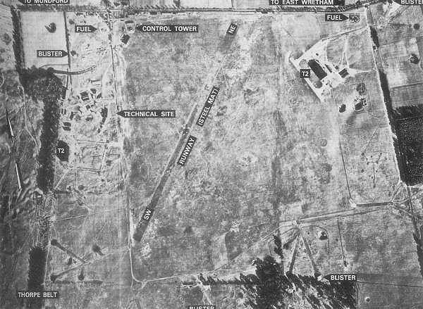
RAF East Wretham

Royal Air Force East Wretham or more simply RAF East Wretham is a former Royal Air Force station located 6 miles (9.7 km) northeast of Thetford, Norfolk...

Bridgham and Brettenham Heaths

Bridgham and Brettenham Heaths is a 439.9-hectare (1,087-acre) biological Site of Special Scientific Interest north-east of Thetford in Norfolk, England...

Nearby Amenities

Located within 500m of 52.457665,0.81621831
Pipeline: marker
Ref: A6NR 6103 CP 0400
Substance: gas
Lat/Long: 52.4592052/0.8118776
Fixme: incomplete
Lat/Long: 52.4590425/0.8128193
Barrier: kissing_gate
Lat/Long: 52.4619377/0.8142481
Barrier: kissing_gate
Lat/Long: 52.4593085/0.8118096
Fixme: incomplete
Lat/Long: 52.4592686/0.8129198
Pipeline: marker
Substance: gas
Lat/Long: 52.4579546/0.8181219
Barrier: kissing_gate
Bicycle: no
Foot: yes
Lat/Long: 52.459222/0.8128937
Barrier: kissing_gate
Bicycle: no
Foot: yes
Lat/Long: 52.4590898/0.8128305
Information: board
Operator: Wildlife Trust
Tourism: information
Lat/Long: 52.4619411/0.8143481
The data included in this document is from www.openstreetmap.org. The data is made available under ODbL.

Have you been to East Wretham Heath?

Leave your review of East Wretham Heath below (or comments, questions and feedback).