Joist Fen

Downs, Moorland in Suffolk West Suffolk

England

Joist Fen

Little Ouse River Bordering Lakenheath RSPB reserve.
Little Ouse River Credit: Hugh Venables

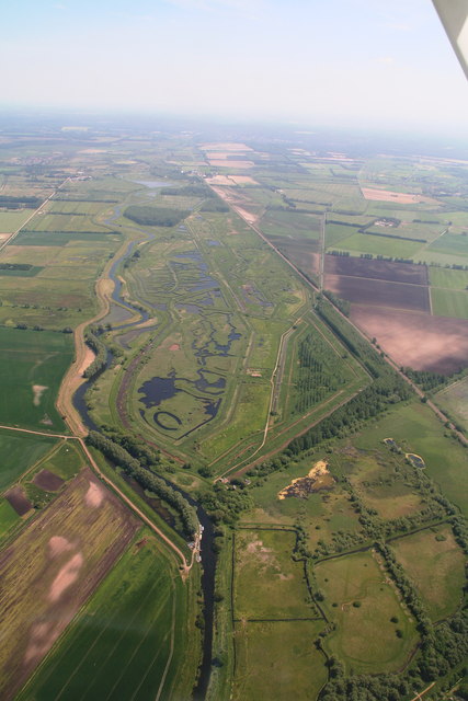
Joist Fen is a picturesque area located in Suffolk, England, known for its diverse landscapes comprising of downs, moorland, and wetlands. Situated within the larger Breckland Area of Outstanding Natural Beauty, Joist Fen offers visitors a unique and tranquil experience.

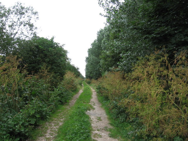
The downs in Joist Fen are characterized by gently rolling hills covered in dense grasses and wildflowers. These open grasslands provide a perfect habitat for various plant species, including heather and gorse. The downs also offer breathtaking panoramic views of the surrounding countryside, making it a popular spot for hikers and nature enthusiasts.

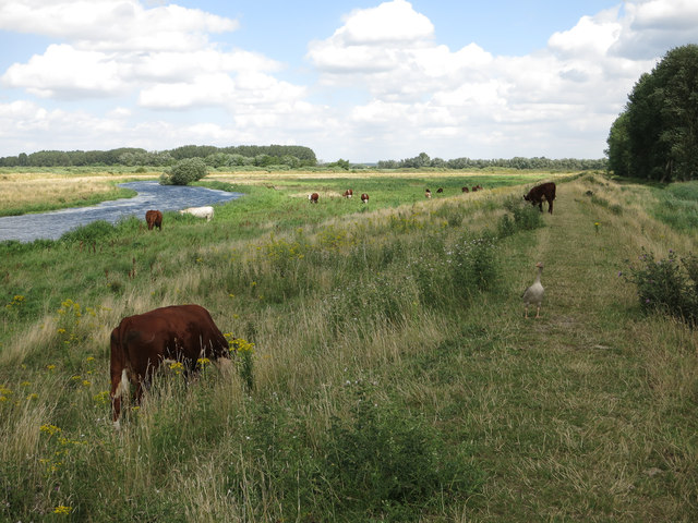
Adjacent to the downs, the moorland of Joist Fen presents a different landscape with its vast expanses of heathland and scattered patches of woodland. This diverse habitat supports a wide range of wildlife, including birds such as the stonechat and skylark, as well as reptiles like the common lizard and adder.

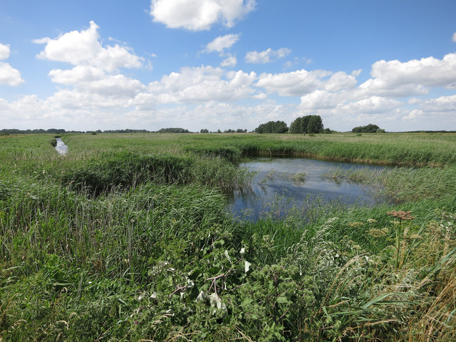
The wetlands in Joist Fen are particularly noteworthy, as they provide a haven for numerous species of waterfowl and wading birds. This marshy area is home to several rare and protected species, such as the bittern and marsh harrier. Nature lovers can observe these birds in their natural habitat by exploring the well-maintained walking trails and bird hides.

Overall, Joist Fen in Suffolk offers visitors a chance to immerse themselves in the beauty of nature. Whether it's exploring the rolling downs, wandering through the moorland, or observing the rich birdlife in the wetlands, this area provides a diverse and captivating experience for all who venture here.

If you have any feedback on the listing, please let us know in the comments section below.

Joist Fen Images

Images are sourced within 2km of 52.443782/0.4870316 or Grid Reference TL6985. Thanks to Geograph Open Source API. All images are credited.

Little Ouse River Bordering Lakenheath RSPB reserve.
Little Ouse River
Bordering Lakenheath RSPB reserve.
Little Ouse River With grazing cows and a slightly confused young Greylag Goose.
Little Ouse River
With grazing cows and a slightly confused young Greylag Goose.
Lakenheath RSPB reserve The reserve has recreated an extensive reedbed from what was previously vegetable fields (and before the drainage a few centuries ago was part of a huge wetland)
Lakenheath RSPB reserve
The reserve has recreated an extensive reedbed from what was previously vegetable fields (and before the drainage a few centuries ago was part of a huge wetland)
Joist Fen Lakenheath RSPB reserve, with a maturing reedbed. Compare with <a href="https://www.geograph.org.uk/photo/495533">TL6985 : Joist Fen</a>.
Joist Fen
Lakenheath RSPB reserve, with a maturing reedbed. Compare with TL6985 : Joist Fen.
Lakenheath Fen Nature Reserve and Little Ouse River: aerial 2015
Joist Fen
Joist Fen
Fen and woodland near Flack's Farm
Joist Fen
Joist Fen
Stallode Wash Looking NNW along the Hereward Way at Stallode Wash
Stallode Wash
Looking NNW along the Hereward Way at Stallode Wash
Joist Fen Joist Fen drainage channels near Lakenheath
Joist Fen
Joist Fen drainage channels near Lakenheath
Track and ditch at Alder Fen Drainage ditches have to kept clear in this low-lying fenland area.
Track and ditch at Alder Fen
Drainage ditches have to kept clear in this low-lying fenland area.
Lakenheath New Lode Viewed from the footbridge across the river.
Lakenheath New Lode
Viewed from the footbridge across the river.
Washland Wetland along the Little Ouse River between the river and banks lining the fields. This system allows water to be pumped from the fields to maintain a lower water level than the river (some land locally is even below sea level). This happens to the north but to the south the land has been reverted to fenland by the RSPB so remains wet. There is mooring along the river for permit holders.
Washland
Wetland along the Little Ouse River between the river and banks lining the fields. This system allows water to be pumped from the fields to maintain a lower water level than the river (some land locally is even below sea level). This happens to the north but to the south the land has been reverted to fenland by the RSPB so remains wet. There is mooring along the river for permit holders.
Birdwatchers Large numbers of people were visiting the reserve as there was a breeding pair of Cranes present and also Golden Orioles (which this group is looking/waiting for). The RSPB have only just publicised the reserve and opened up various paths (after a long period of habitat recreation), which has increased the number of visitors (as has the cranes' presence) though this is a public footpath which has always had access. It is an excellent place to visit for birds, with Marsh Harrier, Hobby, Garganey, Barn Owl, Grasshopper Warbler, Turtle Dove and Cetti's Warbler also seen (sad that Turtle Dove now qualifies for the list as interesting).
Birdwatchers
Large numbers of people were visiting the reserve as there was a breeding pair of Cranes present and also Golden Orioles (which this group is looking/waiting for). The RSPB have only just publicised the reserve and opened up various paths (after a long period of habitat recreation), which has increased the number of visitors (as has the cranes' presence) though this is a public footpath which has always had access. It is an excellent place to visit for birds, with Marsh Harrier, Hobby, Garganey, Barn Owl, Grasshopper Warbler, Turtle Dove and Cetti's Warbler also seen (sad that Turtle Dove now qualifies for the list as interesting).
Seal of approval Sign detailing the success of the habitat creation at the RSPB Lakenheath Fen reserve for birds and other wildlife. Mostly still legible, the word before 'and barley' is 'carrot' and that before 'and water voles' is 'Otters'.
Seal of approval
Sign detailing the success of the habitat creation at the RSPB Lakenheath Fen reserve for birds and other wildlife. Mostly still legible, the word before 'and barley' is 'carrot' and that before 'and water voles' is 'Otters'.
Little Ouse River Looking across the river to the farmland beyond along a drainage ditch. This land was once fenland (a mix of willow, alder sedge and reed) but was drained for agriculture. The process started in 1634 with the cutting of the Old Bedford river. However the process had to become more reliant on technology as the peaty soil shrank one drained so the fields ended up below the drainage rivers. In some areas of the fens old river beds stand above the fields as the silt compacted less than the peat. Windmills were used initially and steam was introduced in 1820 (at Bottisham Fen). Things are almost coming full circle as the land behind the photographer has been reflooded by the RSPB to recreate fenland. Details of drainage history from <span class="nowrap"><a title="http://web.ukonline.co.uk/jill.lawson/pwillow/engine.htm" rel="nofollow ugc noopener" href="http://web.ukonline.co.uk/jill.lawson/pwillow/engine.htm">Link</a><img style="margin-left:2px;" alt="External link" title="External link - shift click to open in new window" src="https://s1.geograph.org.uk/img/external.png" width="10" height="10"/></span>
Little Ouse River
Looking across the river to the farmland beyond along a drainage ditch. This land was once fenland (a mix of willow, alder sedge and reed) but was drained for agriculture. The process started in 1634 with the cutting of the Old Bedford river. However the process had to become more reliant on technology as the peaty soil shrank one drained so the fields ended up below the drainage rivers. In some areas of the fens old river beds stand above the fields as the silt compacted less than the peat. Windmills were used initially and steam was introduced in 1820 (at Bottisham Fen). Things are almost coming full circle as the land behind the photographer has been reflooded by the RSPB to recreate fenland. Details of drainage history from LinkExternal link
RSPB Lakenheath Fen Towards the western end of this large habitat recreation project, restoring fenland habitat to the fens. This part was added on after the first land acquisition and links the reserve to Botany Bay, which has never been fully drained. This should help significantly in the recolonisation of the area by insects and plants.
RSPB Lakenheath Fen
Towards the western end of this large habitat recreation project, restoring fenland habitat to the fens. This part was added on after the first land acquisition and links the reserve to Botany Bay, which has never been fully drained. This should help significantly in the recolonisation of the area by insects and plants.
Washland An area of open water between the Little Ouse River and the river bank. Having the river banks away from the river allows for water storage when water is pumped off the fields.
Washland
An area of open water between the Little Ouse River and the river bank. Having the river banks away from the river allows for water storage when water is pumped off the fields.
Show me another place!

Joist Fen is located at Grid Ref: TL6985 (Lat: 52.443782, Lng: 0.4870316)

Administrative County: Suffolk

District: West Suffolk

Police Authority: Suffolk

What 3 Words

///constants.tiredness.iteration. Near Lakenheath, Suffolk

Nearby Locations

Joist Fen

Related Wikis

Lakenheath Fen RSPB reserve

Lakenheath Fen RSPB reserve is located on the Norfolk/Suffolk border in England, between Lakenheath and Hockwold cum Wilton adjacent to Lakenheath railway...

Stallode Wash, Lakenheath

Stallode Wash, Lakenheath is a 34.1-hectare (84-acre) biological Site of Special Scientific Interest north-west of Lakenheath in Suffolk. This is grassland...

Lakenheath Poor's Fen

Lakenheath Poor's Fen is a 5.2-hectare biological Site of Special Scientific Interest west of Lakenheath in Suffolk. This is mainly fen with diverse flora...

Lakenheath railway station

Lakenheath railway station is on the Breckland Line in the east of England, serving the village of Lakenheath, Suffolk. The line runs between Cambridge...

Nearby Amenities

Located within 500m of 52.443782,0.4870316
Railway: level_crossing
Lat/Long: 52.4402247/0.4841433
Railway: level_crossing
Lat/Long: 52.4401843/0.484111
The data included in this document is from www.openstreetmap.org. The data is made available under ODbL.

Have you been to Joist Fen?

Leave your review of Joist Fen below (or comments, questions and feedback).