Creekgall Fen

Downs, Moorland in Cambridgeshire Fenland

England

Creekgall Fen

New Addition Since my post in May 2007 there has been the addition of a turbine to the sewage treatment works in Creek Fen.
New Addition Credit: Tony Bennett

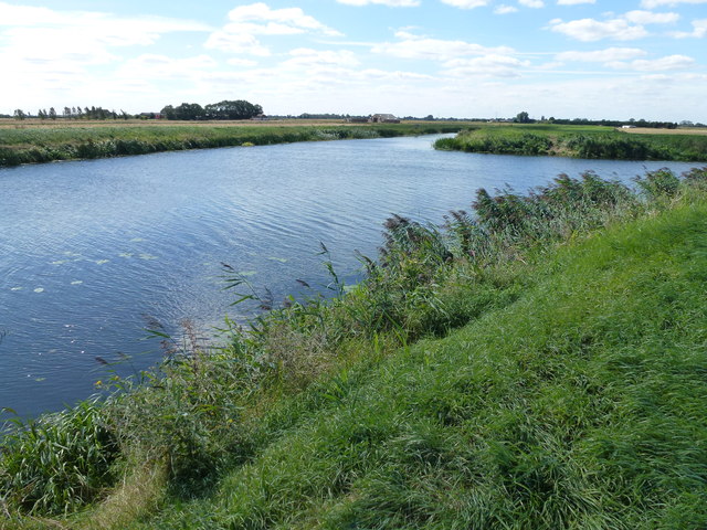
Creekgall Fen is a unique and diverse natural reserve located in Cambridgeshire, England. Covering an area of approximately 100 hectares, the fen is situated on the outskirts of the village of Downs, in a stunning moorland landscape. This protected area is managed by the local wildlife trust and offers visitors a chance to explore the rich biodiversity of the region.

The fen is characterized by its wetland habitat, with shallow pools, reed beds, and extensive areas of marshland. It is home to a wide variety of plant species, including rare orchids, sedges, and water lilies. These plants provide a vital habitat for numerous bird species, such as bitterns, marsh harriers, and kingfishers, making Creekgall Fen a popular spot for birdwatching enthusiasts.

In addition to its diverse flora and fauna, the fen is also of historical importance. Archaeological evidence suggests that the area has been inhabited since the Bronze Age, with remnants of ancient settlements and burial mounds still visible today. The site has been designated as a Scheduled Ancient Monument, preserving its cultural significance.

Visitors to Creekgall Fen can enjoy a range of activities, including guided walks, nature trails, and bird spotting. The reserve also provides educational programs, allowing visitors to learn about the importance of wetland conservation and the unique ecosystems found in the area.

Overall, Creekgall Fen is a hidden gem in Cambridgeshire, offering a tranquil and captivating experience for nature lovers, history enthusiasts, and anyone seeking to explore the beauty of the English countryside.

If you have any feedback on the listing, please let us know in the comments section below.

Creekgall Fen Images

Images are sourced within 2km of 52.580601/0.13594794 or Grid Reference TF4400. Thanks to Geograph Open Source API. All images are credited.

New Addition Since my post in May 2007 there has been the addition of a turbine to the sewage treatment works in Creek Fen.
New Addition
Since my post in May 2007 there has been the addition of a turbine to the sewage treatment works in Creek Fen.
The Twenty Foot River east of Chain Bridge, March The road, Coldham Bank, eventually becomes a track/green lane
The Twenty Foot River east of Chain Bridge, March
The road, Coldham Bank, eventually becomes a track/green lane
The Twenty Foot River south of Stags Holt near March The new wind turbine is within the March Sewage Works. It appears to be of a different design to the dozen or so on the other side of the river
The Twenty Foot River south of Stags Holt near March
The new wind turbine is within the March Sewage Works. It appears to be of a different design to the dozen or so on the other side of the river
The River Nene (old course) near Creek Road, March Coldham and Stags Holt wind farms in the distance
The River Nene (old course) near Creek Road, March
Coldham and Stags Holt wind farms in the distance
Shepperson's Bridge and The Twenty Foot River, March Now used only as a foot bridge. Several very large concrete blocks are positioned on the northern bank to prevent vehicles crossing it
Shepperson's Bridge and The Twenty Foot River, March
Now used only as a foot bridge. Several very large concrete blocks are positioned on the northern bank to prevent vehicles crossing it
Rusting rails on Shepperson's Bridge Looking west along The Twenty Foot River next to March Sewage Works
Rusting rails on Shepperson's Bridge
Looking west along The Twenty Foot River next to March Sewage Works
The Twenty Foot Drain joins The River Nene (old course) To the east of March in Cambridgeshire
The Twenty Foot Drain joins The River Nene (old course)
To the east of March in Cambridgeshire
Cultivated rape seed stubble field and distant windfarm North of The River Nene (old course) east of March
Cultivated rape seed stubble field and distant windfarm
North of The River Nene (old course) east of March
Narrow boat heading towards March On The River Nene (old course) near Reed Fen Farm
Narrow boat heading towards March
On The River Nene (old course) near Reed Fen Farm
Creek Farms Pumping Station in the distance Looking north east along The River Nene (old course) east of March
Creek Farms Pumping Station in the distance
Looking north east along The River Nene (old course) east of March
Coldham and Stags Holt Windfarms A view from the bank of The River Nene (old course) near Creek Farms Pumping Station
Coldham and Stags Holt Windfarms
A view from the bank of The River Nene (old course) near Creek Farms Pumping Station
Green energy, brown fields and a blue sky Wind Farm at Stags Holt and Coldham between Wisbech and March
Green energy, brown fields and a blue sky
Wind Farm at Stags Holt and Coldham between Wisbech and March
Building a straw stack near March - Photo 1 of 5 Gone are the days of laboriously collecting small bales and manually loading them one by one onto an elevator to build a stack. This vertically tipping tractor drawn chassis can be loaded with 12 big bales which are stood upright, the whole process taking no more than 10 minutes. See <a title="https://www.geograph.org.uk/photo/3111808#form" href="https://www.geograph.org.uk/photo/3111808#form">Link</a>
To see bales being collected on another farm see <a title="https://www.geograph.org.uk/photo/3064448" href="https://www.geograph.org.uk/photo/3064448">Link</a>
Building a straw stack near March - Photo 1 of 5
Gone are the days of laboriously collecting small bales and manually loading them one by one onto an elevator to build a stack. This vertically tipping tractor drawn chassis can be loaded with 12 big bales which are stood upright, the whole process taking no more than 10 minutes. See Link To see bales being collected on another farm see Link
Building a straw stack near March - Photo 2 of 5 Gone are the days of laboriously collecting small bales and manually loading them one by one onto an elevator to build a stack. This vertically tipping tractor drawn chassis can be loaded with 12 big bales which are stood upright, the whole process taking no more than 10 minutes. See <a title="https://www.geograph.org.uk/photo/3111813#form" href="https://www.geograph.org.uk/photo/3111813#form">Link</a>
To see bales being collected on another farm see  <a title="https://www.geograph.org.uk/photo/3064448" href="https://www.geograph.org.uk/photo/3064448">Link</a>
Building a straw stack near March - Photo 2 of 5
Gone are the days of laboriously collecting small bales and manually loading them one by one onto an elevator to build a stack. This vertically tipping tractor drawn chassis can be loaded with 12 big bales which are stood upright, the whole process taking no more than 10 minutes. See Link To see bales being collected on another farm see Link
Building a straw stack near March - Photo 3 of 5 Gone are the days of laboriously collecting small bales and manually loading them one by one onto an elevator to build a stack. This vertically tipping tractor drawn chassis can be loaded with 12 big bales which are stood upright, the whole process taking no more than 10 minutes. See <a title="https://www.geograph.org.uk/photo/3111819" href="https://www.geograph.org.uk/photo/3111819">Link</a>
To see bales being collected on another farm see <a title="https://www.geograph.org.uk/photo/3064448" href="https://www.geograph.org.uk/photo/3064448">Link</a>
Building a straw stack near March - Photo 3 of 5
Gone are the days of laboriously collecting small bales and manually loading them one by one onto an elevator to build a stack. This vertically tipping tractor drawn chassis can be loaded with 12 big bales which are stood upright, the whole process taking no more than 10 minutes. See Link To see bales being collected on another farm see Link
Building a straw stack near March - Photo 4 of 5 Gone are the days of laboriously collecting small bales and manually loading them one by one onto an elevator to build a stack. This vertically tipping tractor drawn chassis can be loaded with 12 big bales which are stood upright, the whole process taking no more than 10 minutes. See <a title="https://www.geograph.org.uk/photo/3111826" href="https://www.geograph.org.uk/photo/3111826">Link</a>
To see bales being collected on another farm see <a title="https://www.geograph.org.uk/photo/3064448" href="https://www.geograph.org.uk/photo/3064448">Link</a>
Building a straw stack near March - Photo 4 of 5
Gone are the days of laboriously collecting small bales and manually loading them one by one onto an elevator to build a stack. This vertically tipping tractor drawn chassis can be loaded with 12 big bales which are stood upright, the whole process taking no more than 10 minutes. See Link To see bales being collected on another farm see Link
Building a straw stack near March - Photo 5 of 5 Gone are the days of laboriously collecting small bales and manually loading them one by one onto an elevator to build a stack. This vertically tipping tractor drawn chassis can be loaded with 12 big bales which are stood upright, the whole process taking no more than 10 minutes. See <a title="https://www.geograph.org.uk/photo/3111802" href="https://www.geograph.org.uk/photo/3111802">Link</a>
To see bales being collected on another farm see <a href="https://www.geograph.org.uk/photo/3064448">TL1283 : Bale cart with a chaser</a>
Building a straw stack near March - Photo 5 of 5
Gone are the days of laboriously collecting small bales and manually loading them one by one onto an elevator to build a stack. This vertically tipping tractor drawn chassis can be loaded with 12 big bales which are stood upright, the whole process taking no more than 10 minutes. See Link To see bales being collected on another farm see TL1283 : Bale cart with a chaser
Reed Fen Pump Reed Fen pumping station. In the background, Stags Holt wind turbines.
Reed Fen Pump
Reed Fen pumping station. In the background, Stags Holt wind turbines.
Show me another place!

Creekgall Fen is located at Grid Ref: TF4400 (Lat: 52.580601, Lng: 0.13594794)

Division: Isle of Ely

Administrative County: Cambridgeshire

District: Fenland

Police Authority: Cambridgeshire

What 3 Words

///entrusted.disarmed.dripped. Near March, Cambridgeshire

Nearby Locations

Creekgall Fen

Related Wikis

Dunhams Wood

Dunhams Wood is a privately owned broadleaved woodland that is occasionally open to the public. The area was planted over a period of 6 years starting...

March Elm Road railway station

March Elm Road railway station is a proposed station in March, Cambridgeshire, which if successful, the Bramley Line will make as the southern terminus...

Waldersea railway station

Waldersea railway station is a proposed station situated on the former Wisbech line from March to Wisbech, and will be the proposed terminal of the railway...

Coldham railway station

Coldham railway station was a station in Coldham, Cambridgeshire. It was on the branch of the Great Eastern Railway which ran from March to Watlington...

Coldham, Cambridgeshire

Coldham is a hamlet in Elm civil parish, part of the Fenland district of the Isle of Ely, Cambridgeshire, England. Coldham is the site of a wind farm on...

Norwood Road nature reserve

Norwood Road is a nature reserve managed by the Wildlife Trust for Bedfordshire, Cambridgeshire, Northamptonshire and Peterborough. It lies in the centre...

Wisbech and March line

The Wisbech and March line is a railway line between March and Wisbech in Cambridgeshire, England. A number of proposals are currently being investigated...

March railway station

March railway station is on the Ely–Peterborough line in the east of England and serves the market town of March, Cambridgeshire. It is 85 miles 76 chains...

Nearby Amenities

Located within 500m of 52.580601,0.13594794
Generator Method: wind_turbine
Generator Output Electricity: yes
Generator Source: wind
Generator Type: horizontal_axis
Power: generator
Lat/Long: 52.5807369/0.141743
Generator Method: wind_turbine
Generator Output Electricity: yes
Generator Source: wind
Generator Type: horizontal_axis
Power: generator
Lat/Long: 52.5778762/0.140618
The data included in this document is from www.openstreetmap.org. The data is made available under ODbL.

Have you been to Creekgall Fen?

Leave your review of Creekgall Fen below (or comments, questions and feedback).