Middle Fen

Downs, Moorland in Lincolnshire South Holland

England

Middle Fen

Northorpe Road, Donington Northorpe, Lincs – view ESE from near the junction with Day's Lane.
Northorpe Road, Donington Northorpe, Lincs Credit: Rodney Burton

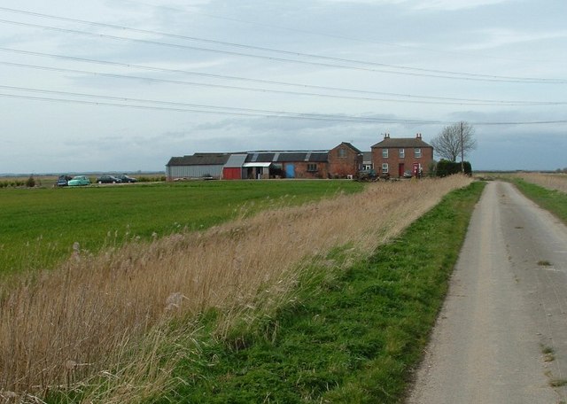
Middle Fen is a vast expanse of low-lying wetland located in Lincolnshire, England. The area is characterized by its flat terrain, with a mixture of marshes, bogs, and ponds creating a unique and diverse ecosystem. The fens are crisscrossed by numerous drainage channels and ditches, which have been dug over the centuries to manage water levels and reclaim land for agriculture.

The landscape of Middle Fen is dotted with small farms and villages, with fields of crops such as wheat, barley, and potatoes stretching out into the distance. The area is also home to a variety of wildlife, including birds such as marsh harriers, bitterns, and whooper swans, as well as mammals like otters and water voles.

Middle Fen is part of the Lincolnshire Wolds, an Area of Outstanding Natural Beauty known for its scenic beauty and rich biodiversity. The fens provide a habitat for many rare and endangered species, making it an important area for conservation efforts. Visitors to Middle Fen can enjoy walking and birdwatching, as well as learning about the history and ecology of this unique landscape.

If you have any feedback on the listing, please let us know in the comments section below.

Middle Fen Images

Images are sourced within 2km of 52.922003/-0.22433069 or Grid Reference TF1937. Thanks to Geograph Open Source API. All images are credited.

Northorpe Road, Donington Northorpe, Lincs – view ESE from near the junction with Day's Lane.
Northorpe Road, Donington Northorpe, Lincs
– view ESE from near the junction with Day's Lane.
Ing Farm Farm near to the end of South Drove Bicker Fen
Ing Farm
Farm near to the end of South Drove Bicker Fen
Cowbridge from Longhedge Drove Land lying fallow close to Cow Bridge, Bicker Gauntlet
Cowbridge from Longhedge Drove
Land lying fallow close to Cow Bridge, Bicker Gauntlet
Ridge Patterns Freshly planted potato crops strike geometric patterns either side of the A52 Donington bypass
Ridge Patterns
Freshly planted potato crops strike geometric patterns either side of the A52 Donington bypass
Donington, Old cemetery A little way outside the village to the North is the resting place of many former Doningtonians. It is now considered to be full and a new burial ground is starting to come into use to the West of the Church. The railings divide the consecrated ground from the public path that runs toward Northorpe crossing "Wikes drain" via a wooden footbridge.
Donington, Old cemetery
A little way outside the village to the North is the resting place of many former Doningtonians. It is now considered to be full and a new burial ground is starting to come into use to the West of the Church. The railings divide the consecrated ground from the public path that runs toward Northorpe crossing "Wikes drain" via a wooden footbridge.
Gravediggers Store Small brick store in the old cemetery used to house a "beare", this was a four wheeled hand trolley with a platform top that was used to assist the pall bearers move the casket over a long distance. The building is in a fair state of repair with only a few of the ridge crests broken.
Gravediggers Store
Small brick store in the old cemetery used to house a "beare", this was a four wheeled hand trolley with a platform top that was used to assist the pall bearers move the casket over a long distance. The building is in a fair state of repair with only a few of the ridge crests broken.
Donington Bypass The A52 Westwards from the junction with Church Street. The tree line on the left of the picture conceal the church from passing travellers.
Donington Bypass
The A52 Westwards from the junction with Church Street. The tree line on the left of the picture conceal the church from passing travellers.
Clearly signed Footpath to the Southwest of the A52 Donington bypass, the signage is concise but the path is indistinct. Make your own mind up as to which hole in the hedge is the way through.
Clearly signed
Footpath to the Southwest of the A52 Donington bypass, the signage is concise but the path is indistinct. Make your own mind up as to which hole in the hedge is the way through.
Triple carriageway Farm track leading North from the A52. There are three distinct wheel tracks which makes one think that three wheeled tractors are back in fashion.
Triple carriageway
Farm track leading North from the A52. There are three distinct wheel tracks which makes one think that three wheeled tractors are back in fashion.
Wikes Drain, Donington Northorpe View looking East along the Wikes Drain. The drain is named as such on the 1:25000 map but suspect it may also be spelt Wykes as it does flow toward Donington Wykes.[TF2235]
Wikes Drain, Donington Northorpe
View looking East along the Wikes Drain. The drain is named as such on the 1:25000 map but suspect it may also be spelt Wykes as it does flow toward Donington Wykes.[TF2235]
Footbridge over Wikes Drain The Public Footpath that runs from Donington to Northorpe crosses the Wikes Drain.
Footbridge over Wikes Drain
The Public Footpath that runs from Donington to Northorpe crosses the Wikes Drain.
Between the "Tates" The Footpath that runs from the cemetery at Donington to Northorpe forms a green belt between two Potato fields.
Between the "Tates"
The Footpath that runs from the cemetery at Donington to Northorpe forms a green belt between two Potato fields.
Missing Link Although clearly waymarked the Eastern arm of the Footpath from Donington to Northorpe has been cropped over with Potatoes.
Missing Link
Although clearly waymarked the Eastern arm of the Footpath from Donington to Northorpe has been cropped over with Potatoes.
Path end The Western arm of Footpath from Donington ends here in Northorpe. The Brown Fen trail is marked on the same post.
Path end
The Western arm of Footpath from Donington ends here in Northorpe. The Brown Fen trail is marked on the same post.
Post, path & phone The Eastern arm of the Footpath from Donington arrives here, but is truncated by cropping along its length.
Post, path & phone
The Eastern arm of the Footpath from Donington arrives here, but is truncated by cropping along its length.
Holyrood Close Junction of Holyrood Close and Northorpe Road, Donington.
Holyrood Close
Junction of Holyrood Close and Northorpe Road, Donington.
Quiet Road View Southwest along Northorpe Road, Donington, Lincs..
Quiet Road
View Southwest along Northorpe Road, Donington, Lincs..
Pumping Station Small Pumping station on the South bank of Wikes Drain, to the side of Northorpe Road, Donington.
Pumping Station
Small Pumping station on the South bank of Wikes Drain, to the side of Northorpe Road, Donington.
Show me another place!

Middle Fen is located at Grid Ref: TF1937 (Lat: 52.922003, Lng: -0.22433069)

Administrative County: Lincolnshire

District: South Holland

Police Authority: Lincolnshire

What 3 Words

///failed.zaps.hairstyle. Near Donington, Lincolnshire

Nearby Locations

Middle Fen

Related Wikis

Bicker Gauntlet

Bicker Gauntlet is a village in Lincolnshire, England. It is in the civil parish of Bicker. == External links == Media related to Bicker Gauntlet at Wikimedia...

Donington Road railway station

Donington Road railway station was a station in Lincolnshire on the line between Spalding and Sleaford. == References == == External links == Donington...

Cowley Academy

Cowley Academy (formally The Thomas Cowley High School) is a mixed secondary school with Academy status, in Donington, Lincolnshire, England. As of 1 September...

Donington, Lincolnshire

Donington is a village and civil parish in the South Holland district of Lincolnshire, England. It is 8 miles (13 km) north from the market town of Spalding...

Nearby Amenities

Located within 500m of 52.922003,-0.22433069
Generator Method: wind_turbine
Generator Output Electricity: yes
Generator Source: wind
Generator Type: horizontal_axis
Power: generator
Lat/Long: 52.9249716/-0.2250374
Middle Fen
Place: locality
Source: Bing
Lat/Long: 52.9229099/-0.2232406
The data included in this document is from www.openstreetmap.org. The data is made available under ODbL.

Have you been to Middle Fen?

Leave your review of Middle Fen below (or comments, questions and feedback).