Church Meadow

Downs, Moorland in Lincolnshire South Kesteven

England

Church Meadow

Bainton parish church, Peterborough Dedicated to St Mary; view from Tallington Road.
Bainton parish church, Peterborough Credit: Rodney Burton

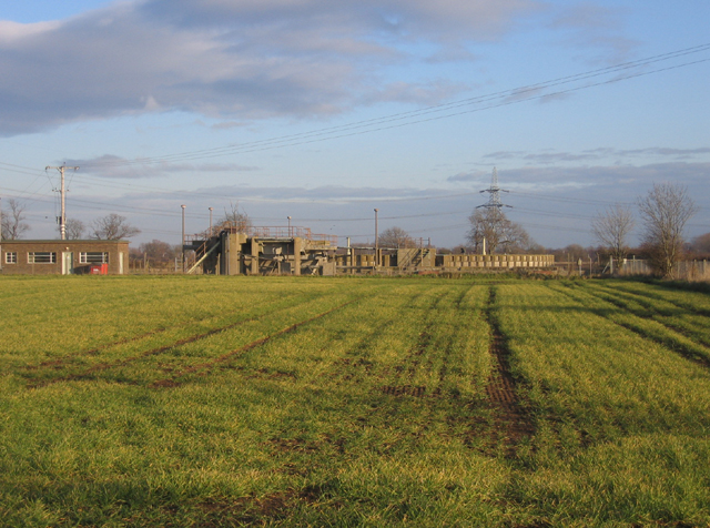
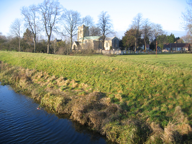
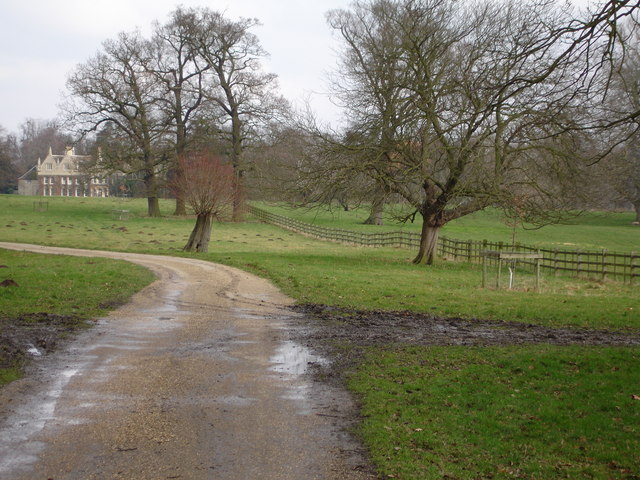
Church Meadow is a picturesque area located in Lincolnshire, England. It is characterized by its diverse landscape, including downs and moorland. The meadow is known for its natural beauty and rich history, attracting visitors from near and far.

The downs in Church Meadow are rolling hills covered in lush green grass, offering stunning views of the surrounding countryside. These hills provide a peaceful and serene environment for visitors to enjoy nature and engage in recreational activities such as walking, picnicking, and bird-watching. The area is home to a variety of plant species, including wildflowers, which add vibrant colors to the landscape.

The moorland in Church Meadow is a vast expanse of open land covered in heather and grasses. It is a unique ecosystem that supports a wide range of wildlife, including birds, insects, and small mammals. The moorland is an important habitat for endangered species, making it a popular spot for nature enthusiasts and conservationists.

In addition to its natural beauty, Church Meadow holds historical significance. The area is dotted with ancient churches and ruins that date back centuries, providing a glimpse into the region's past. These structures serve as a reminder of the cultural and religious heritage of Lincolnshire.

Overall, Church Meadow in Lincolnshire is a remarkable destination that offers a blend of breathtaking scenery, diverse ecosystems, and historical landmarks. Whether visitors are seeking tranquility, outdoor activities, or a glimpse into the past, Church Meadow has something to offer for everyone.

If you have any feedback on the listing, please let us know in the comments section below.

Church Meadow Images

Images are sourced within 2km of 52.65502/-0.3900366 or Grid Reference TF0907. Thanks to Geograph Open Source API. All images are credited.

Bainton parish church, Peterborough Dedicated to St Mary; view from Tallington Road.
Bainton parish church, Peterborough
Dedicated to St Mary; view from Tallington Road.
Sewage works, Bainton, Peterborough
Tallington parish church, Lincs Dedicated to St Lawrence; the tower is 14th C and the nave arcades and transepts are primarily 13th C <span class="nowrap"><a title="http://www.crsbi.ac.uk/ed/li/talli/" rel="nofollow ugc noopener" href="http://www.crsbi.ac.uk/ed/li/talli/">Link</a><img style="margin-left:2px;" alt="External link" title="External link - shift click to open in new window" src="https://s1.geograph.org.uk/img/external.png" width="10" height="10"/></span> . View NW from the bridge over the Maxey Cut.
Tallington parish church, Lincs
Dedicated to St Lawrence; the tower is 14th C and the nave arcades and transepts are primarily 13th C LinkExternal link . View NW from the bridge over the Maxey Cut.
Tallington railway level crossing, Lincs The A16 road crosses the King's Cross–Edinburgh main line; view SE from the footbridge looking 'up'.
Tallington railway level crossing, Lincs
The A16 road crosses the King's Cross–Edinburgh main line; view SE from the footbridge looking 'up'.
East coast main line, Tallington, Lincs View NW looking 'down'.
East coast main line, Tallington, Lincs
View NW looking 'down'.
Grounds of Casewick Hall, near Uffington Lincs.
Entrance gates to Casewick hall, near Uffington, Lincs
River Welland Looking west opposite Copthill farm
River Welland
Looking west opposite Copthill farm
River Welland with Swans River Welland halfway between Uffington and Tallington
River Welland with Swans
River Welland halfway between Uffington and Tallington
The Torpel Way crossing a stream north of Barnack
The fields towards Bainton from the Torpel Way Bainton Church spire <a href="https://www.geograph.org.uk/gridref/TF0906">TF0906</a> just visible in the trees
The fields towards Bainton from the Torpel Way
Bainton Church spire TF0906 just visible in the trees
Casewick Park and  Eastern Gatehouse
Casewick Park and Eastern Gatehouse
Small Pond off Farm track Gatehouse to Casewick Park in the distance
Small Pond off Farm track
Gatehouse to Casewick Park in the distance
Field of Sunflowers near Tallington This sunflower crop has been grown for cattle feed or bird food
Field of Sunflowers near Tallington
This sunflower crop has been grown for cattle feed or bird food
Tallington Crossing A speeding GNER train travelling south over the Tallington Level Crossing.
Tallington Crossing
A speeding GNER train travelling south over the Tallington Level Crossing.
Tarmac precast concrete works Tallington From the 2:10 NXEC Kings Cross Leeds.
Tarmac precast concrete works Tallington
From the 2:10 NXEC Kings Cross Leeds.
Small Watercourse A small, unnamed watercourse passing under Casewick Lane, Uffington.
Small Watercourse
A small, unnamed watercourse passing under Casewick Lane, Uffington.
Barholm Road The road from Tallington to Barholm, between Tallington Lakes and tarmac precast concrete works.
Barholm Road
The road from Tallington to Barholm, between Tallington Lakes and tarmac precast concrete works.
Show me another place!

Church Meadow is located at Grid Ref: TF0907 (Lat: 52.65502, Lng: -0.3900366)

Administrative County: Lincolnshire

District: South Kesteven

Police Authority: Lincolnshire

What 3 Words

///composer.surfaces.solicitor. Near Barnack, Cambridgeshire

Nearby Locations

Tallington Church Meadow

Related Wikis

Tallington

Tallington is a village and civil parish in the South Kesteven district of Lincolnshire, England. The population of the civil parish at the 2011 census...

Tallington railway station

Tallington railway station was a station in Tallington, Lincolnshire on the Great Northern Railway between Grantham and Peterborough. It was closed in...

Bainton Gate railway station

Bainton Gate railway station was a short lived railway "station" in the Soke of Peterborough (now in Cambridgeshire) on the Syston and Peterborough Railway...

Bainton, Cambridgeshire

Bainton is a village and civil parish in the Peterborough unitary authority area of Cambridgeshire, England. Bainton is on the southern edge of the Welland...

Nearby Amenities

Located within 500m of 52.65502,-0.3900366
Design: barrel
Line Attachment: suspension
Material: steel
Power: tower
Structure: lattice
Lat/Long: 52.6542926/-0.3894575
Design: barrel
Line Attachment: suspension
Material: steel
Power: tower
Structure: lattice
Lat/Long: 52.6530321/-0.384491
Design: barrel
Line Attachment: suspension
Material: steel
Power: tower
Structure: lattice
Lat/Long: 52.6553538/-0.3936388
Parking
Lat/Long: 52.6579266/-0.3941559
Parking
Lat/Long: 52.657458/-0.3958403
Church Meadow
Place: locality
Source: Bing
Lat/Long: 52.6551266/-0.3890911
Home Farm
Place: farm
Source: Bing
Lat/Long: 52.658116/-0.3884049
West Marsh
Place: locality
Source: Bing
Lat/Long: 52.6569241/-0.3938789
Building: yes
Lat/Long: 52.657305/-0.3849055
Power: pole
Lat/Long: 52.6590321/-0.391164
Power: pole
Lat/Long: 52.6580177/-0.3925802
Power: pole
Lat/Long: 52.6573791/-0.3934962
Power: pole
Lat/Long: 52.6569073/-0.3955829
The data included in this document is from www.openstreetmap.org. The data is made available under ODbL.

Have you been to Church Meadow?

Leave your review of Church Meadow below (or comments, questions and feedback).