Skidby Carr

Downs, Moorland in Yorkshire

England

Skidby Carr

Old milestone On the A1174 at the south end of Woodmansey is this typical East Riding milestone shaped as a 3 step mounting block.  The tombstone shape metal plate on the front has the inscription HULL/5/MILES but is very rusty.  In 2001 it was found half- buried and leaning back into the dyke.  It was raised and restored by the Highways Unit but now the plate needs repainting.
Old milestone Credit: Chris Minto

Skidby Carr is a picturesque area located in the East Riding of Yorkshire, England. It is situated in the Yorkshire Wolds, known for its stunning downs and moorland landscapes. Covering an area of approximately 200 acres, Skidby Carr is a haven for nature enthusiasts and those seeking tranquility amidst the beauty of the countryside.

The landscape of Skidby Carr is characterized by gently rolling hills, vast open fields, and patches of dense woodland. The area is home to a wide variety of flora and fauna, making it a popular destination for birdwatchers and wildlife enthusiasts. Visitors can expect to spot a range of bird species, including skylarks, lapwings, and yellowhammers, as well as mammals such as hares and foxes.

The Carr itself is a wetland area, encompassing marshes, ponds, and small streams. It provides a crucial habitat for various aquatic plants and animals, including waterfowl and dragonflies. The wetland ecosystem also plays a vital role in flood prevention and water purification.

The surrounding countryside offers numerous walking trails and bridleways, allowing visitors to explore the area at their leisure. The panoramic views from the higher points of Skidby Carr are particularly breathtaking, offering vistas of the rolling hills and expansive moorland.

Skidby Carr is also home to the Skidby Windmill, a well-preserved example of a traditional English windmill. Dating back to 1821, the windmill stands as a testament to the area's rich agricultural history and is open to the public as a museum.

Overall, Skidby Carr is a haven of natural beauty, offering visitors a serene escape from the hustle and bustle of modern life. Its diverse landscapes, abundant wildlife, and historic windmill make it an ideal destination for those seeking to immerse themselves in the charm of the Yorkshire countryside.

If you have any feedback on the listing, please let us know in the comments section below.

Skidby Carr Images

Images are sourced within 2km of 53.804659/-0.38355696 or Grid Reference TA0635. Thanks to Geograph Open Source API. All images are credited.

Old milestone On the A1174 at the south end of Woodmansey is this typical East Riding milestone shaped as a 3 step mounting block.  The tombstone shape metal plate on the front has the inscription HULL/5/MILES but is very rusty.  In 2001 it was found half- buried and leaning back into the dyke.  It was raised and restored by the Highways Unit but now the plate needs repainting.
Old milestone
On the A1174 at the south end of Woodmansey is this typical East Riding milestone shaped as a 3 step mounting block. The tombstone shape metal plate on the front has the inscription HULL/5/MILES but is very rusty. In 2001 it was found half- buried and leaning back into the dyke. It was raised and restored by the Highways Unit but now the plate needs repainting.
Old milestone A view of the back of the 5 miles from Hull milestone at the southern end of Woodmansey on the A1174 showing the inscribed bench mark.  This also shows erosion and old damage to the edges and steps.
Old milestone
A view of the back of the 5 miles from Hull milestone at the southern end of Woodmansey on the A1174 showing the inscribed bench mark. This also shows erosion and old damage to the edges and steps.
Old milestone This eroded sandstone milestone probably has three steps with the lower one under soil level.  It is on the A1174 just south of Woodmansey church and by lamppost 58.   The tombstone shape of the missing plate which was inset into the stone and fixed by one large peg at the top can be seen.  It is on the east side of the road.
Old milestone
This eroded sandstone milestone probably has three steps with the lower one under soil level. It is on the A1174 just south of Woodmansey church and by lamppost 58. The tombstone shape of the missing plate which was inset into the stone and fixed by one large peg at the top can be seen. It is on the east side of the road.
Ings Bridge, Beverley Road, Hull - 1979 The bus is on an enthusiast tour commemorating the end of operation of the AEC Renown type of bus by the East Yorkshire company.

This is one of a series of views featuring buses in the 60s, 70s, and 80s. <a title="https://www.geograph.org.uk/search.php?i=137652761" href="https://www.geograph.org.uk/search.php?i=137652761">Link</a> 

The bridge as seen here has completely disappeared with the development of the road as a dual carriageway and with the 'angle' of the bend eased into a longer gradual curve. The bridge also marks the location of the boundary of the City of Kingston upon Hull.
Ings Bridge, Beverley Road, Hull - 1979
The bus is on an enthusiast tour commemorating the end of operation of the AEC Renown type of bus by the East Yorkshire company. This is one of a series of views featuring buses in the 60s, 70s, and 80s. Link The bridge as seen here has completely disappeared with the development of the road as a dual carriageway and with the 'angle' of the bend eased into a longer gradual curve. The bridge also marks the location of the boundary of the City of Kingston upon Hull.
Animals grazing at Hampston Hill North of Long Lane
Animals grazing at Hampston Hill
North of Long Lane
Cattle near Dunswell Part of a herd grazing on Skidby Carr, to the north and east of Dunswell Lane
Cattle near Dunswell
Part of a herd grazing on Skidby Carr, to the north and east of Dunswell Lane
Trees near Dunswell Seen from Dunswell Lane, a pair of oaks in a field to the south of the road.
Trees near Dunswell
Seen from Dunswell Lane, a pair of oaks in a field to the south of the road.
Paddock near Dunswell Home to several horses to the west of Beverley High Road, south of the Dunswell roundabout.
Paddock near Dunswell
Home to several horses to the west of Beverley High Road, south of the Dunswell roundabout.
Linn Park, Hull
Linn Park, Hull
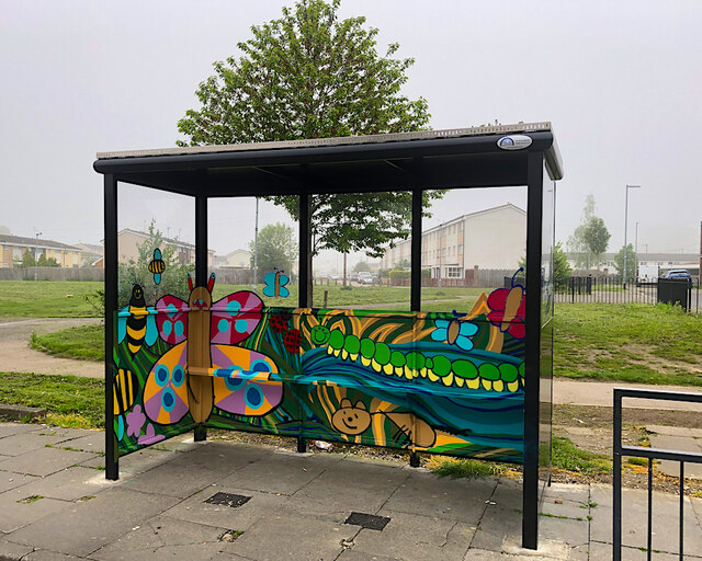
Wildlife-themed shelter, Hull Hull City Council provided 19 new bus shelters in March 2023, along Hedon Road and Hall Road, to replace old ones in poor condition. These all included 'wildflower roofs', planted to attract bees and other pollinators. Some, like this one, were also painted by a local artist working with students from the city's schools. This example in Hall Road reflects the project's ecological aspect.

Other examples of similar painted shelters include: <a href="https://www.geograph.org.uk/photo/7483495">TA1329 : Painted bus shelter, Hedon Road, Hull</a> <a href="https://www.geograph.org.uk/photo/7483496">TA0633 : Hall Road painted shelter, Hull</a> and <a href="https://www.geograph.org.uk/photo/7483498">TA0632 : Painted bus shelter, Hall Road, Hull</a>
Wildlife-themed shelter, Hull
Hull City Council provided 19 new bus shelters in March 2023, along Hedon Road and Hall Road, to replace old ones in poor condition. These all included 'wildflower roofs', planted to attract bees and other pollinators. Some, like this one, were also painted by a local artist working with students from the city's schools. This example in Hall Road reflects the project's ecological aspect. Other examples of similar painted shelters include: TA1329 : Painted bus shelter, Hedon Road, Hull TA0633 : Hall Road painted shelter, Hull and TA0632 : Painted bus shelter, Hall Road, Hull
Alpaca at Dunswell Belonging to Alpacas at The Field on Dunswell Lane <span class="nowrap"><a title="https://www.alpacasatthefield.co.uk/" rel="nofollow ugc noopener" href="https://www.alpacasatthefield.co.uk/">Link</a><img style="margin-left:2px;" alt="External link" title="External link - shift click to open in new window" src="https://s1.geograph.org.uk/img/external.png" width="10" height="10"/></span> which offers alpaca walking 'experiences'.
Alpaca at Dunswell
Belonging to Alpacas at The Field on Dunswell Lane LinkExternal link which offers alpaca walking 'experiences'.
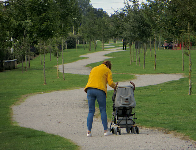
The long and winding path, Hull The path runs along the north-western edge of the huge Kingswood housing development to the east of the River Hull.
The long and winding path, Hull
The path runs along the north-western edge of the huge Kingswood housing development to the east of the River Hull.
Dead tree, Sir Henry Cooper Park, Hull In the centre of the small park (effectively a dog-walking area in reality) off Thorpepark Road on the Orchard Park estate. The park is named after the Sir Henry Cooper School which stood on the site but closed in 2012, which in turn was named after a 19th century mayor of Hull (not the 20th century boxer).
Dead tree, Sir Henry Cooper Park, Hull
In the centre of the small park (effectively a dog-walking area in reality) off Thorpepark Road on the Orchard Park estate. The park is named after the Sir Henry Cooper School which stood on the site but closed in 2012, which in turn was named after a 19th century mayor of Hull (not the 20th century boxer).
Ennerdale Link bridges, Hull A view from the eastern side, of the bridges depicted at <a href="https://www.geograph.org.uk/photo/2775013">TA0834 : Ennerdale Link bridges, Hull</a>
Ennerdale Link bridges, Hull
A view from the eastern side, of the bridges depicted at TA0834 : Ennerdale Link bridges, Hull
Fields south of Long Lane Looking across farmland to the south of Long Lane on a damp Friday.
Fields south of Long Lane
Looking across farmland to the south of Long Lane on a damp Friday.
Bend on Long Lane Long Lane heads south from Beverley before heading east to meet the A1174.
Bend on Long Lane
Long Lane heads south from Beverley before heading east to meet the A1174.
Fields north of Long Lane Long Lane heads south from Beverley before heading east to meet the A1174.
Fields north of Long Lane
Long Lane heads south from Beverley before heading east to meet the A1174.
Greenhouses along Long Lane Long Lane heads south from Beverley before heading east to meet the A1174.
Greenhouses along Long Lane
Long Lane heads south from Beverley before heading east to meet the A1174.
Show me another place!

Skidby Carr is located at Grid Ref: TA0635 (Lat: 53.804659, Lng: -0.38355696)

Division: East Riding

Unitary Authority: East Riding of Yorkshire

Police Authority: Humberside

What 3 Words

///salad.tester.engine. Near Dunswell, East Yorkshire

Nearby Locations

Skidby Carr

Related Wikis

Dunswell

Dunswell is a village in the East Riding of Yorkshire, England, and in the civil parish of Woodmansey. Historically also known as Beer-Houses due to the...

Hull United A.F.C.

Hull United Association Football Club is a football club in Hull, East Riding of Yorkshire, England. They were members of Division One of the Northern...

Westella & Willerby F.C.

Westella & Willerby Football Club is an English football club based in Willerby, East Riding of Yorkshire, they play their home games at Hill Top, Willerby...

Sir Henry Cooper School

Sir Henry Cooper School was a coeducational, secondary school located on Thorpepark Road in Orchard Park Estate, Kingston upon Hull, England. On the school...

Nearby Amenities

Located within 500m of 53.804659,-0.38355696
Power: tower
Lat/Long: 53.8019055/-0.3858951
Power: tower
Lat/Long: 53.802647/-0.3771943
Power: tower
Lat/Long: 53.8030149/-0.3816388
Power: tower
Lat/Long: 53.8067647/-0.3884347
Power: tower
Lat/Long: 53.8074492/-0.3843433
Power: tower
Lat/Long: 53.8081007/-0.3805137
The data included in this document is from www.openstreetmap.org. The data is made available under ODbL.

Have you been to Skidby Carr?

Leave your review of Skidby Carr below (or comments, questions and feedback).