Laskill Pasture Moor
Downs, Moorland in Yorkshire Ryedale
England
Laskill Pasture Moor
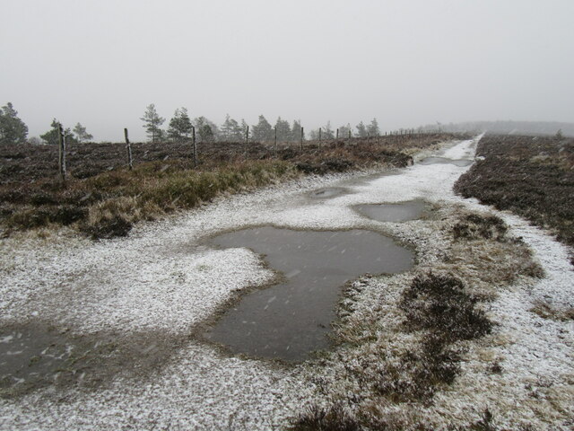
![WW2 Bombing target SW apex A strange feature to come across in the middle of a grouse moor.
What appear to be two tracks, coming together at an angle of precisely 60°.
The left hand track is about 27 yards long, and meets another track from the right. Again the angle is 60°.
Once more, the left hand track is about 27 yards long, and meets another track from the right. Again the angle is 60°.
Continuing clockwise I return to my starting point.
Three sides, each about 27 metres with internal angles of 60°. A perfect equilateral triangle.
A quick look at Google Earth gives an overview see <span class="nowrap"><a title="https://earth.google.com/web/@54.32279057,-1.10081693,515.13299509a,0d,35y,-0.0362h,24.3366t,0r?utm_source=earth7&amp;utm_campaign=vine&amp;hl=en" rel="nofollow ugc noopener" href="https://earth.google.com/web/@54.32279057,-1.10081693,515.13299509a,0d,35y,-0.0362h,24.3366t,0r?utm_source=earth7&amp;utm_campaign=vine&amp;hl=en">Link</a><img style="margin-left:2px;" alt="External link" title="External link - shift click to open in new window" src="https://s1.geograph.org.uk/img/external.png" width="10" height="10"/></span> .
A clue to its purpose perhaps is revealed by a brick and concrete structure some 100 yards to the north.
The triangle was a practice bombing target and the building was the observation hut, probably dating from the early 1950s.
The target would have been painted yellow and lit up at night with lamps. I assume dummy bombs would have been used, otherwise the observing officers in the bunker seem a bit too close for comfort.
I believe the aircraft came from RAF Wombleton where Royal Canadian Air Force personnel were being converted to fly heavy bombers.
RAF Wombleton opened in October 1943, just north of Nunnington, and was a sub-station of RAF Dalton (Topcliffe). It was the base for 1,200 N.C.O.s, airmen and airwomen, and operated both Halifaxes and Lancasters. The airfield closed in the early 1950s.
Sources:
North York Moors National Park. (2012). HER Map: North York Moors National Park. HER Nos.: 18522 and 18292. [online] Available at: <span class="nowrap"><a title="https://www.northyorkmoors.org.uk/discover/archaeology/her-map" rel="nofollow ugc noopener" href="https://www.northyorkmoors.org.uk/discover/archaeology/her-map">Link</a><img style="margin-left:2px;" alt="External link" title="External link - shift click to open in new window" src="https://s1.geograph.org.uk/img/external.png" width="10" height="10"/></span> [Accessed 8 Dec. 2021].
&#039;Airmen&#039;s Club on the Yorkshire Moors&#039; (1945) Hull Daily Mail, 26 Jul, 7, available: <span class="nowrap"><a title="https://link-gale-com.ezproxy.is.ed.ac.uk/apps/doc/EN3223221123/GDCS?u=ed_itw&amp;sid=bookmark-GDCS&amp;xid=d663ea52" rel="nofollow ugc noopener" href="https://link-gale-com.ezproxy.is.ed.ac.uk/apps/doc/EN3223221123/GDCS?u=ed_itw&amp;sid=bookmark-GDCS&amp;xid=d663ea52">Link</a><img style="margin-left:2px;" alt="External link" title="External link - shift click to open in new window" src="https://s1.geograph.org.uk/img/external.png" width="10" height="10"/></span> [accessed 08 Dec 2021].](https://s1.geograph.org.uk/geophotos/07/03/94/7039425_0953bd0b.jpg)
Laskill Pasture Moor is a picturesque expanse of moorland located in the county of Yorkshire, England. Situated in the heart of the North York Moors National Park, it covers an area of approximately 2,000 hectares.
The moorland is characterized by its rolling hills, heather- covered expanses, and scattered patches of woodland. Laskill Pasture Moor boasts a diverse range of flora and fauna, making it a haven for nature enthusiasts and conservationists. The heather, in particular, is a prominent feature, painting the landscape in vibrant shades of purple during the summer months.
The moorland is home to a variety of bird species, including grouse, curlews, and lapwings, making it a popular destination for birdwatchers. The area also supports a population of rare and protected species such as red grouse and merlin.
Laskill Pasture Moor offers a network of footpaths and trails, allowing visitors to explore the stunning surroundings. These paths offer panoramic views of the surrounding countryside, including the iconic Yorkshire Dales and the Vale of York.
The moorland is managed by the North York Moors National Park Authority, which works tirelessly to protect and preserve its natural beauty. The authorities actively manage the heather through controlled burning to support the growth of new plants and maintain a healthy ecosystem.
Laskill Pasture Moor is a tranquil and beautiful location, offering visitors the opportunity to immerse themselves in the breathtaking landscapes and experience the unique charm of the Yorkshire moorlands.
If you have any feedback on the listing, please let us know in the comments section below.
Laskill Pasture Moor Images
Images are sourced within 2km of 54.317112/-1.1093938 or Grid Reference SE5891. Thanks to Geograph Open Source API. All images are credited.
![Bombing target N apex A strange feature to come across in the middle of a grouse moor.
What appear to be two tracks, coming together at an angle of precisely 60°.
The left hand track is about 27 yards long, and meets another track from the right. Again the angle is 60°.
Once more, the left hand track is about 27 yards long, and meets another track from the right. Again the angle is 60°.
Continuing clockwise I return to my starting point.
Three sides, each about 27 metres with internal angles of 60°. A perfect equilateral triangle.
A quick look at Google Earth gives an overview see <span class="nowrap"><a title="https://earth.google.com/web/@54.32279057,-1.10081693,515.13299509a,0d,35y,-0.0362h,24.3366t,0r?utm_source=earth7&amp;utm_campaign=vine&amp;hl=en" rel="nofollow ugc noopener" href="https://earth.google.com/web/@54.32279057,-1.10081693,515.13299509a,0d,35y,-0.0362h,24.3366t,0r?utm_source=earth7&amp;utm_campaign=vine&amp;hl=en">Link</a><img style="margin-left:2px;" alt="External link" title="External link - shift click to open in new window" src="https://s1.geograph.org.uk/img/external.png" width="10" height="10"/></span> .
A clue to its purpose perhaps is revealed by a brick and concrete structure some 100 yards to the north.
The triangle was a practice bombing target and the building was the observation hut, probably dating from the early 1950s.
The target would have been painted yellow and lit up at night with lamps. I assume dummy bombs would have been used, otherwise the observing officers in the bunker seem a bit too close for comfort.
I believe the aircraft came from RAF Wombleton where Royal Canadian Air Force personnel were being converted to fly heavy bombers.
RAF Wombleton opened in October 1943, just north of Nunnington, and was a sub-station of RAF Dalton (Topcliffe). It was the base for 1,200 N.C.O.s, airmen and airwomen, and operated both Halifaxes and Lancasters. The airfield closed in the early 1950s.
Sources:
North York Moors National Park. (2012). HER Map: North York Moors National Park. HER Nos.: 18522 and 18292. [online] Available at: <span class="nowrap"><a title="https://www.northyorkmoors.org.uk/discover/archaeology/her-map" rel="nofollow ugc noopener" href="https://www.northyorkmoors.org.uk/discover/archaeology/her-map">Link</a><img style="margin-left:2px;" alt="External link" title="External link - shift click to open in new window" src="https://s1.geograph.org.uk/img/external.png" width="10" height="10"/></span> [Accessed 8 Dec. 2021].
&#039;Airmen&#039;s Club on the Yorkshire Moors&#039; (1945) Hull Daily Mail, 26 Jul, 7, available: <span class="nowrap"><a title="https://link-gale-com.ezproxy.is.ed.ac.uk/apps/doc/EN3223221123/GDCS?u=ed_itw&amp;sid=bookmark-GDCS&amp;xid=d663ea52" rel="nofollow ugc noopener" href="https://link-gale-com.ezproxy.is.ed.ac.uk/apps/doc/EN3223221123/GDCS?u=ed_itw&amp;sid=bookmark-GDCS&amp;xid=d663ea52">Link</a><img style="margin-left:2px;" alt="External link" title="External link - shift click to open in new window" src="https://s1.geograph.org.uk/img/external.png" width="10" height="10"/></span> [accessed 08 Dec 2021].](https://s3.geograph.org.uk/geophotos/07/03/94/7039427_b9d429c8.jpg)
![Bombing target E apex A strange feature to come across in the middle of a grouse moor.
What appear to be two tracks, coming together at an angle of precisely 60°.
The left hand track is about 27 yards long, and meets another track from the right. Again the angle is 60°.
Once more, the left hand track is about 27 yards long, and meets another track from the right. Again the angle is 60°.
Continuing clockwise I return to my starting point.
Three sides, each about 27 metres with internal angles of 60°. A perfect equilateral triangle.
A quick look at Google Earth gives an overview see <span class="nowrap"><a title="https://earth.google.com/web/@54.32279057,-1.10081693,515.13299509a,0d,35y,-0.0362h,24.3366t,0r?utm_source=earth7&amp;utm_campaign=vine&amp;hl=en" rel="nofollow ugc noopener" href="https://earth.google.com/web/@54.32279057,-1.10081693,515.13299509a,0d,35y,-0.0362h,24.3366t,0r?utm_source=earth7&amp;utm_campaign=vine&amp;hl=en">Link</a><img style="margin-left:2px;" alt="External link" title="External link - shift click to open in new window" src="https://s1.geograph.org.uk/img/external.png" width="10" height="10"/></span> .
A clue to its purpose perhaps is revealed by a brick and concrete structure some 100 yards to the north.
The triangle was a practice bombing target and the building was the observation hut, probably dating from the early 1950s.
The target would have been painted yellow and lit up at night with lamps. I assume dummy bombs would have been used, otherwise the observing officers in the bunker seem a bit too close for comfort.
I believe the aircraft came from RAF Wombleton where Royal Canadian Air Force personnel were being converted to fly heavy bombers.
RAF Wombleton opened in October 1943, just north of Nunnington, and was a sub-station of RAF Dalton (Topcliffe). It was the base for 1,200 N.C.O.s, airmen and airwomen, and operated both Halifaxes and Lancasters. The airfield closed in the early 1950s.
Sources:
North York Moors National Park. (2012). HER Map: North York Moors National Park. HER Nos.: 18522 and 18292. [online] Available at: <span class="nowrap"><a title="https://www.northyorkmoors.org.uk/discover/archaeology/her-map" rel="nofollow ugc noopener" href="https://www.northyorkmoors.org.uk/discover/archaeology/her-map">Link</a><img style="margin-left:2px;" alt="External link" title="External link - shift click to open in new window" src="https://s1.geograph.org.uk/img/external.png" width="10" height="10"/></span> [Accessed 8 Dec. 2021].
&#039;Airmen&#039;s Club on the Yorkshire Moors&#039; (1945) Hull Daily Mail, 26 Jul, 7, available: <span class="nowrap"><a title="https://link-gale-com.ezproxy.is.ed.ac.uk/apps/doc/EN3223221123/GDCS?u=ed_itw&amp;sid=bookmark-GDCS&amp;xid=d663ea52" rel="nofollow ugc noopener" href="https://link-gale-com.ezproxy.is.ed.ac.uk/apps/doc/EN3223221123/GDCS?u=ed_itw&amp;sid=bookmark-GDCS&amp;xid=d663ea52">Link</a><img style="margin-left:2px;" alt="External link" title="External link - shift click to open in new window" src="https://s1.geograph.org.uk/img/external.png" width="10" height="10"/></span> [accessed 08 Dec 2021].](https://s2.geograph.org.uk/geophotos/07/03/94/7039430_19ed5bf9.jpg)
![Bombing target observation bunker A strange feature to come across in the middle of a grouse moor.
What appear to be two tracks, coming together at an angle of precisely 60°.
The left hand track is about 27 yards long, and meets another track from the right. Again the angle is 60°.
Once more, the left hand track is about 27 yards long, and meets another track from the right. Again the angle is 60°.
Continuing clockwise I return to my starting point.
Three sides, each about 27 metres with internal angles of 60°. A perfect equilateral triangle.
A quick look at Google Earth gives an overview see <span class="nowrap"><a title="https://earth.google.com/web/@54.32279057,-1.10081693,515.13299509a,0d,35y,-0.0362h,24.3366t,0r?utm_source=earth7&amp;utm_campaign=vine&amp;hl=en" rel="nofollow ugc noopener" href="https://earth.google.com/web/@54.32279057,-1.10081693,515.13299509a,0d,35y,-0.0362h,24.3366t,0r?utm_source=earth7&amp;utm_campaign=vine&amp;hl=en">Link</a><img style="margin-left:2px;" alt="External link" title="External link - shift click to open in new window" src="https://s1.geograph.org.uk/img/external.png" width="10" height="10"/></span> .
A clue to its purpose perhaps is revealed by a brick and concrete structure some 100 yards to the north.
The triangle was a practice bombing target and the building was the observation hut, probably dating from the early 1950s.
The target would have been painted yellow and lit up at night with lamps. I assume dummy bombs would have been used, otherwise the observing officers in the bunker seem a bit too close for comfort.
I believe the aircraft came from RAF Wombleton where Royal Canadian Air Force personnel were being converted to fly heavy bombers.
RAF Wombleton opened in October 1943, just north of Nunnington, and was a sub-station of RAF Dalton (Topcliffe). It was the base for 1,200 N.C.O.s, airmen and airwomen, and operated both Halifaxes and Lancasters. The airfield closed in the early 1950s.
Sources:
North York Moors National Park. (2012). HER Map: North York Moors National Park. HER Nos.: 18522 and 18292. [online] Available at: <span class="nowrap"><a title="https://www.northyorkmoors.org.uk/discover/archaeology/her-map" rel="nofollow ugc noopener" href="https://www.northyorkmoors.org.uk/discover/archaeology/her-map">Link</a><img style="margin-left:2px;" alt="External link" title="External link - shift click to open in new window" src="https://s1.geograph.org.uk/img/external.png" width="10" height="10"/></span> [Accessed 8 Dec. 2021].
&#039;Airmen&#039;s Club on the Yorkshire Moors&#039; (1945) Hull Daily Mail, 26 Jul, 7, available: <span class="nowrap"><a title="https://link-gale-com.ezproxy.is.ed.ac.uk/apps/doc/EN3223221123/GDCS?u=ed_itw&amp;sid=bookmark-GDCS&amp;xid=d663ea52" rel="nofollow ugc noopener" href="https://link-gale-com.ezproxy.is.ed.ac.uk/apps/doc/EN3223221123/GDCS?u=ed_itw&amp;sid=bookmark-GDCS&amp;xid=d663ea52">Link</a><img style="margin-left:2px;" alt="External link" title="External link - shift click to open in new window" src="https://s1.geograph.org.uk/img/external.png" width="10" height="10"/></span> [accessed 08 Dec 2021].](https://s2.geograph.org.uk/geophotos/07/03/94/7039434_92586d59.jpg)


Laskill Pasture Moor is located at Grid Ref: SE5891 (Lat: 54.317112, Lng: -1.1093938)
Division: North Riding
Administrative County: North Yorkshire
District: Ryedale
Police Authority: North Yorkshire
What 3 Words
///animates.perplexed.sparks. Near Bilsdale, North Yorkshire
Nearby Locations
Related Wikis

Bilsdale
Bilsdale is a dale in the western part of the North York Moors in North Yorkshire, England. The head of the dale is at Hasty Bank, and the dale extends...

Laskill
Laskill is a small hamlet in Bilsdale, 5 miles (8 km) north-west of Helmsley, North Yorkshire, England, on the road from Helmsley to Stokesley and is located...

Hawnby
Hawnby is a small crossroads village and civil parish in Ryedale in the North York Moors National Park, North Yorkshire, England. The village is about...
Bilsdale transmitting station
The Bilsdale transmitting station is a broadcasting and telecommunications facility, located at Bilsdale West Moor above Bilsdale, close to Helmsley, North...
Nearby Amenities
Located within 500m of 54.317112,-1.1093938Have you been to Laskill Pasture Moor?
Leave your review of Laskill Pasture Moor below (or comments, questions and feedback).