Nab End Moor
Downs, Moorland in Yorkshire Hambleton
England
Nab End Moor

Nab End Moor is a picturesque expanse of moorland located in the county of Yorkshire, England. Situated in the region known as the Yorkshire Dales, this area is renowned for its stunning natural beauty and rugged landscape. Spanning over several hectares, Nab End Moor is characterized by its undulating hills, open grassy plains, and heather-covered moorland.
The moorland is located at an elevation, which contributes to its breathtaking views of the surrounding countryside. Visitors to Nab End Moor can expect to be greeted by panoramic vistas of rolling hills, deep valleys, and meandering rivers. The area is also dotted with clusters of trees and patches of woodland, adding to the diversity of the landscape.
Nab End Moor is home to a rich variety of flora and fauna, including several endangered species. The moorland is covered in a vivid purple blanket of heather during the summer months, creating a stunning spectacle that attracts nature enthusiasts and photographers alike. Birdwatchers will be delighted to spot a range of avian species, including red grouse, curlews, and lapwings.
In addition to its natural wonders, Nab End Moor also has a rich cultural history. The area is scattered with remnants of old stone walls, evidence of the agricultural practices that have shaped the landscape over centuries. Walking trails crisscross the moorland, allowing visitors to explore the area and discover its hidden gems.
Overall, Nab End Moor is a captivating destination that offers visitors a chance to immerse themselves in the beauty of the Yorkshire countryside. Whether hiking, birdwatching, or simply enjoying the peaceful atmosphere, this area is a must-visit for nature lovers and those seeking a tranquil escape.
If you have any feedback on the listing, please let us know in the comments section below.
Nab End Moor Images
Images are sourced within 2km of 54.378979/-1.1151376 or Grid Reference SE5798. Thanks to Geograph Open Source API. All images are credited.


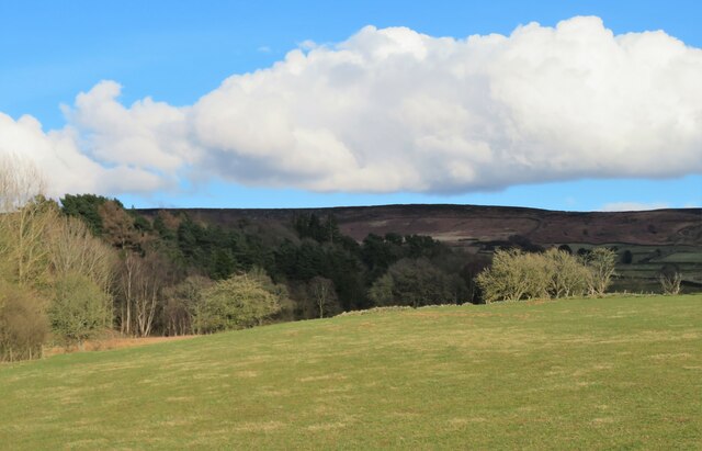
![Tarn Hole Had a trot up to the Bilsdale transmitter to see how the new mast was getting along. As it’s going to take 19 months, I shouldn’t have expected to see anything. There was just one bloke high up the temporary mast. What a view on a vernal morning.
The view was maybe not quite as good from ground level but still impressive.
Across the dale, the ‘secret’ valley of Tarn Hole dominates the far skyline. Secret because no Public Rights of Way pass through it and although the moorland above is Open Access, there are no well trod paths around the escarpment.
George Villiers, the 2nd Duke of Buckingham, was out hunting in Tarn Hole in 1687, when he fell, striking his head on a rock. He was taken to the house of a tenant in Kirkbymoorside, where he caught a chill and died. The rock on which he struck his head is known as the ‘Buckingham Stone’ but it’s not on Open Access Land and the landowner is quite protective so I won’t disclose exactly where it is.
Tarn Hole was the home of one of the moors many hobs, ‘T’Hob o’ Tarn Hole’, those mischievous mercurial elves that attach themselves to a farmstead. But I prefer to think he lived in the delightfully named Ash Nuiken, the woodland that bestrides the beck.
I said earlier there are no well trod paths around the escarpment but a Public Footpath does go from Apple Tree Hurst Farm [<a href="https://www.geograph.org.uk/gridref/SE5896">SE5896</a>]up to the moor and along to Tarn Hole Crag. I must explore this sometime.
Until very recently all the Public Rights of way through Apple Tree Hurst Farm were closed due to an “ongoing police” investigation. Apparently human body parts had been found there.
The story began in 2011 when police found a loaded Luger pistol under the owner’s pillow and a ‘museum’ in an outbuilding containing a military memorabilia a vast collection of machine guns, grenades, mortars and ammunition including the cockpit from a fighter jet.
The police had been following up a case of exposure by the owner, a Ken Ward, to a neighbour. If you want photographs and all the titillating details you best read the Daily Mail article.
Along with the guns, grenades, and pieces of aircraft wreckage, the Police found human remains. These have been identified as belonging to the pilot and navigator of a Mosquito plane, No. DZ543, which crashed on the moors above Bransdale on 11th October 1944. It was on a transit flight from Beccles to Turnberry airfield and hit the moor in low visibility.
The crew P/O Alfred Robert William Milne RAFVR, aged 22, and WO Eric Alan Stubbs RAFVR (1323395), also aged 22, were subsequently buried in Surrey.
But it seems that not all the body parts were recovered by the RAF at the time, and Ward, who had had an obsession with the crash since 1959, when aged 11, had carried out his own excavations to recover further pieces of aircraft for his collection and in doing also found human remains which the RAF had missed.
In their article the Daily Mail reports that “Police say they have now concluded their investigation without any further charges being brought against Ward.”
For links and references see <span class="nowrap"><a title="http://www.fhithich.uk/?p=27464" rel="nofollow ugc noopener" href="http://www.fhithich.uk/?p=27464">Link</a><img style="margin-left:2px;" alt="External link" title="External link - shift click to open in new window" src="https://s1.geograph.org.uk/img/external.png" width="10" height="10"/></span>](https://s2.geograph.org.uk/geophotos/07/10/91/7109122_7d3962e0.jpg)

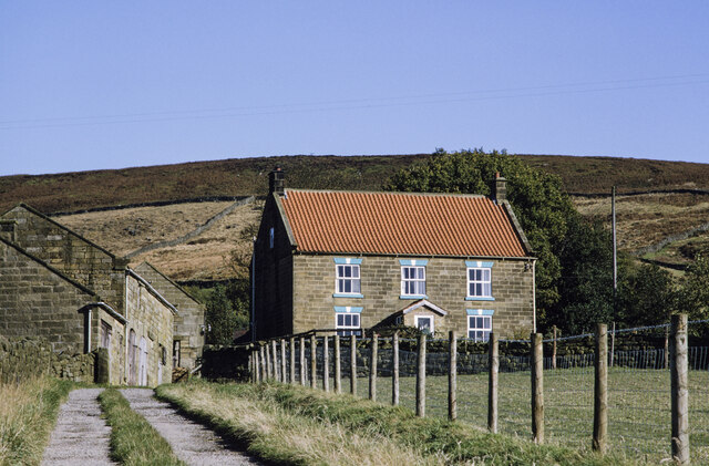
![Cam House, Bilsdale Hillside farmhouse with a view over the dale. Recent tree planting below and to the right of the house across an area marked as &#039;Tips [disused]&#039; on the OS map. Old 6&quot; maps show these as old jet workings.](https://s3.geograph.org.uk/geophotos/07/11/84/7118495_a76ae01b.jpg)


Nab End Moor is located at Grid Ref: SE5798 (Lat: 54.378979, Lng: -1.1151376)
Division: North Riding
Administrative County: North Yorkshire
District: Hambleton
Police Authority: North Yorkshire
What 3 Words
///stag.thankful.breezy. Near Bilsdale, North Yorkshire
Nearby Locations
Related Wikis

Bilsdale Midcable
Bilsdale Midcable is a civil parish in North Yorkshire, England, which occupies the northern part of Bilsdale in the North York Moors National Park. According...

Chop Gate
Chop Gate ( CHOP YAT) is a small village in the Hambleton district of North Yorkshire, England. The village lies within the North York Moors National Park...
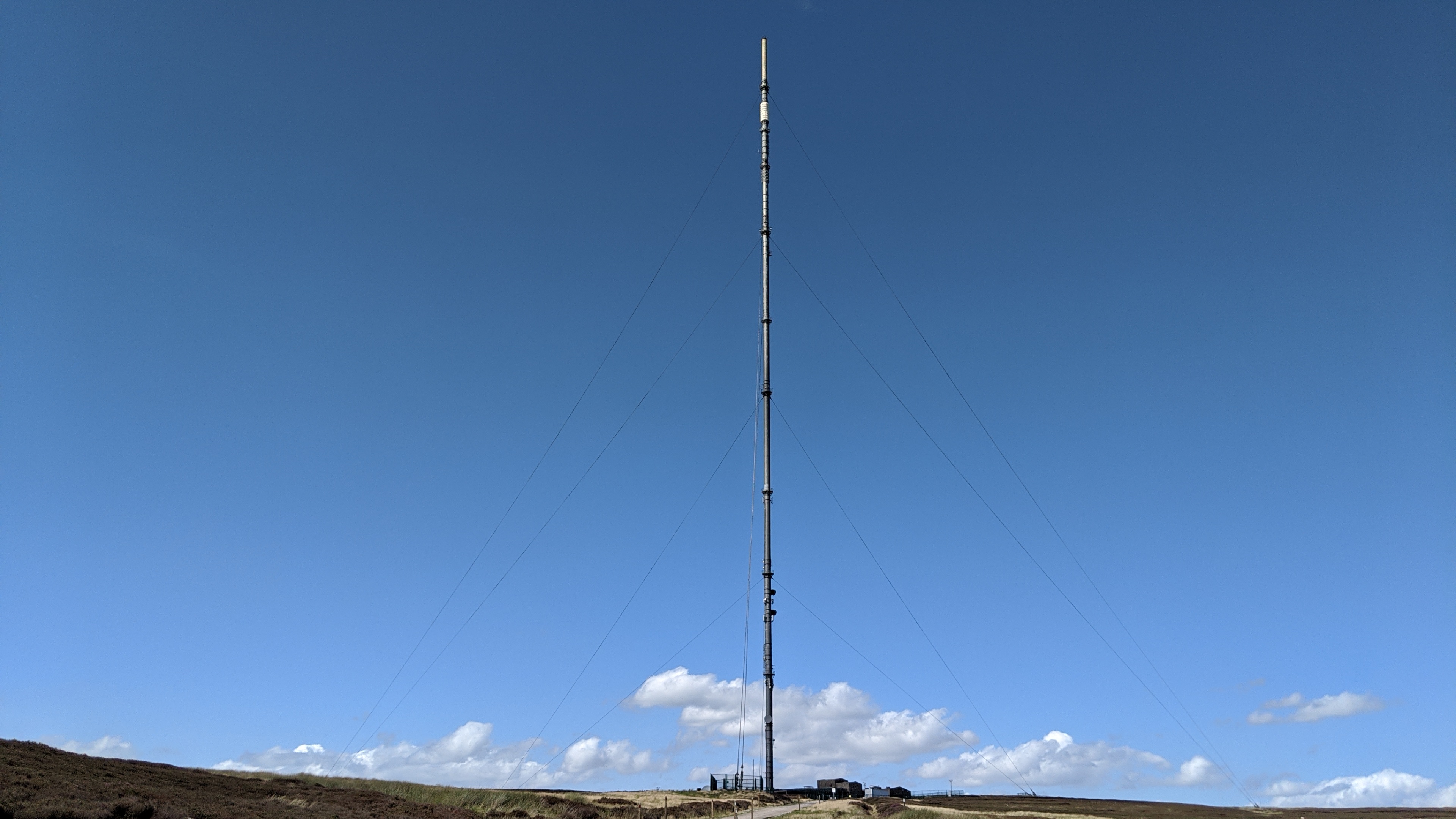
Bilsdale transmitting station
The Bilsdale transmitting station is a broadcasting and telecommunications facility, located at Bilsdale West Moor above Bilsdale, close to Helmsley, North...

Urra Moor
Urra Moor is the highest moor in the North York Moors, North Yorkshire, England. At 1,490 feet (454 m) above sea level it is the highest point in Hambleton...
Have you been to Nab End Moor?
Leave your review of Nab End Moor below (or comments, questions and feedback).