West Field

Downs, Moorland in Yorkshire

England

West Field

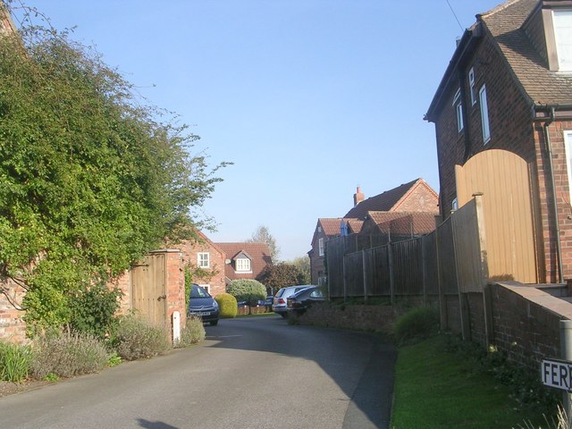
Passing place near Overton Approaching the hamlet of Overton on the east banks of the Ouse.
Passing place near Overton Credit: DS Pugh

West Field is a picturesque area located in Yorkshire, known for its stunning landscape of downs and moorland. The area is characterized by rolling hills, open fields, and vast expanses of heather-covered moorland. West Field is a popular destination for outdoor enthusiasts, offering a range of activities such as hiking, birdwatching, and wildlife spotting.

The downs of West Field are home to a variety of plant and animal species, including rare birds such as the red grouse and the curlew. The moorland is dotted with rocky outcrops and ancient stone formations, adding to the area's rugged beauty.

Visitors to West Field can enjoy breathtaking views across the countryside, with the Yorkshire Dales and Pennines visible in the distance. The area is also rich in history, with numerous archaeological sites dating back to the Bronze Age.

Overall, West Field is a tranquil and scenic location, perfect for those looking to escape the hustle and bustle of city life and immerse themselves in the natural beauty of the Yorkshire countryside.

If you have any feedback on the listing, please let us know in the comments section below.

West Field Images

Images are sourced within 2km of 53.980655/-1.1645869 or Grid Reference SE5454. Thanks to Geograph Open Source API. All images are credited.

Passing place near Overton Approaching the hamlet of Overton on the east banks of the Ouse.
Passing place near Overton
Approaching the hamlet of Overton on the east banks of the Ouse.
Tree on a bend A half dead tree, that has stood like this for years. Also see <a href="https://www.geograph.org.uk/photo/2083955">SE5555 : Tree on a bend</a>.
Tree on a bend
A half dead tree, that has stood like this for years. Also see SE5555 : Tree on a bend.
All  Saint's  Church  Upper  Poppleton
All Saint's Church Upper Poppleton
Maypole  Upper  Poppleton  Village  Green
Maypole Upper Poppleton Village Green
River  Ouse  Upper  Poppleton
River Ouse Upper Poppleton
Coppiced  Willow  Trees On the banks of the River Ouse, grown for Bio Fuel. South Farm is in the background.
Coppiced Willow Trees
On the banks of the River Ouse, grown for Bio Fuel. South Farm is in the background.
Overton  over the River  Ouse
Overton over the River Ouse
Farmland near Overton Manor
Minor road towards the A19
Entering Overton, North Yorkshire
Miller's Barn, Overton
Poppleton Level Crossing, 1986 Class 141 railbus No 141018 has just left the station at Poppleton and crossed Station Rd by means of the level crossing in the autumn of 1986
Poppleton Level Crossing, 1986
Class 141 railbus No 141018 has just left the station at Poppleton and crossed Station Rd by means of the level crossing in the autumn of 1986
The Lord Nelson - Main Street
Main Street - viewed from The Lord Nelson
Ferryman's Walk - Main Street
Footpath - Main Street
Nether Poppleton War Memorial - Main Street
Riverside Gardens - Main Street
Show me another place!

West Field is located at Grid Ref: SE5454 (Lat: 53.980655, Lng: -1.1645869)

Division: West Riding

Unitary Authority: York

Police Authority: North Yorkshire

What 3 Words

///puff.flip.gone. Near Upper Poppleton, North Yorkshire

Nearby Locations

West Field

Related Wikis

All Saints' Church, Upper Poppleton

All Saints' Church is the parish church of Upper Poppleton, a village in the rural north-western part of the City of York district, in the ceremonial county...

Upper Poppleton

Upper Poppleton is a village and civil parish in the unitary authority of the City of York in North Yorkshire, England. It is situated by the west bank...

Poppleton railway station

Poppleton is a railway station on the Harrogate Line, which runs between Leeds and York via Harrogate. The station, situated 2 miles 72 chains (4.7 km...

Overton Hoard

The Overton Hoard is a Roman coin hoard dating from the early 3rd century AD. It contains 37 coins and fragments of a pottery container. It was acquired...

Nearby Amenities

Located within 500m of 53.980655,-1.1645869
Passing Place
Lat/Long: 53.9815989/-1.1706556
Passing Place
Lat/Long: 53.9803406/-1.1710321
Passing Place
Lat/Long: 53.9837932/-1.1679827
Passing Place
Lat/Long: 53.9795732/-1.1593981
Material: wood
Power: pole
Switch: fuse
Lat/Long: 53.9774508/-1.1595001
Material: wood
Power: pole
Lat/Long: 53.9779931/-1.1605204
Fixme: Something else here? Transition?
Material: wood
Power: tower
Lat/Long: 53.9785647/-1.1615556
Material: wood
Power: pole
Lat/Long: 53.9790602/-1.1624494
Material: wood
Power: pole
Lat/Long: 53.9795522/-1.1633672
Material: wood
Power: pole
Lat/Long: 53.9800459/-1.1642971
Material: wood
Power: pole
Lat/Long: 53.9805432/-1.1652029
Material: wood
Power: pole
Lat/Long: 53.9810496/-1.1661546
Material: wood
Power: pole
Lat/Long: 53.981196/-1.1672435
Material: wood
Power: pole
Lat/Long: 53.9813565/-1.1683021
Material: wood
Power: pole
Lat/Long: 53.9815058/-1.1694287
Design: h-frame
Material: wood
Power: tower
Switch: mechanical
Lat/Long: 53.9816484/-1.1704904
Material: wood
Power: pole
Lat/Long: 53.981951/-1.1717238
Passing Place
Lat/Long: 53.9797913/-1.171485
The data included in this document is from www.openstreetmap.org. The data is made available under ODbL.

Have you been to West Field?

Leave your review of West Field below (or comments, questions and feedback).