The Moors

Downs, Moorland in Hampshire Basingstoke and Deane

England

The Moors

Trees starting on the heathland Following decades as a military airfield, Greenham Common is returning to a natural state. The thin gravel soil supports colourful expanses of heather, but birch trees are now starting to take over.
Trees starting on the heathland Credit: Des Blenkinsopp

The Moors in Hampshire, also known as the Hampshire Downs or Moorland, is a vast and picturesque expanse located in the southern part of England. Spanning an area of approximately 1,400 square kilometers, it is renowned for its stunning natural beauty and diverse wildlife.

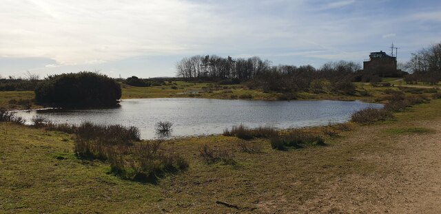
The Moors are characterized by rolling hills, expansive grasslands, and heathlands, creating a captivating landscape that is a haven for outdoor enthusiasts and nature lovers. The area is home to an array of flora and fauna, including rare species of plants such as the vibrant purple heather and the delicate harebell.

The Moors boast a rich cultural and historical heritage. Archaeological remains and ancient monuments can be found scattered throughout the region, serving as a testament to its past. These include ancient burial mounds, Iron Age hillforts, and remnants of Roman settlements, providing insights into the area's human occupation over thousands of years.

The Moors offer a wide range of recreational activities for visitors to enjoy. Walking and hiking trails crisscross the landscape, offering breathtaking views of the surrounding countryside. The area also provides excellent opportunities for birdwatching, with species such as the red kite, buzzard, and skylark commonly spotted.

In addition to its natural attractions, the Moors are dotted with charming villages and towns that exude a quintessentially British charm. These settlements offer cozy pubs, quaint tea rooms, and local craft shops, providing a glimpse into the traditional rural life of Hampshire.

Overall, the Moors in Hampshire are a captivating destination that combines natural beauty, historical significance, and cultural charm, making it a must-visit location for both locals and tourists alike.

If you have any feedback on the listing, please let us know in the comments section below.

The Moors Images

Images are sourced within 2km of 51.368141/-1.2783913 or Grid Reference SU5063. Thanks to Geograph Open Source API. All images are credited.

Trees starting on the heathland Following decades as a military airfield, Greenham Common is returning to a natural state. The thin gravel soil supports colourful expanses of heather, but birch trees are now starting to take over.
Trees starting on the heathland
Following decades as a military airfield, Greenham Common is returning to a natural state. The thin gravel soil supports colourful expanses of heather, but birch trees are now starting to take over.
Track on Greenham Common Good tracks like this are all over the common, plus a lot of smaller paths, making it very easy to get around.
Track on Greenham Common
Good tracks like this are all over the common, plus a lot of smaller paths, making it very easy to get around.
Bowdown Woods To the north of Bury's Bank Road, the scenery is quite different from the open heathland of Greenham Common to the south. It is predominantly woodland.
Bowdown Woods
To the north of Bury's Bank Road, the scenery is quite different from the open heathland of Greenham Common to the south. It is predominantly woodland.
Pasture, Bishop's Green With woodland on the Berkshire side of the River Enborne.
Pasture, Bishop's Green
With woodland on the Berkshire side of the River Enborne.
Pasture, Ecchinswell The footpath seen descending to Hyde Lane.
Pasture, Ecchinswell
The footpath seen descending to Hyde Lane.
Pond at Greenham Common A shallow pond formed by heavy rain on Greenham Common. The old control tower - now a cafe - can be seen in the background.
Pond at Greenham Common
A shallow pond formed by heavy rain on Greenham Common. The old control tower - now a cafe - can be seen in the background.
Lay-by off Bury's Bank Road A lay-by off Bury's Bank Road beside Greenham Common. The road runs from Newbury to Thatcham, with livestock across part of it in-between two cattle grids.
Lay-by off Bury's Bank Road
A lay-by off Bury's Bank Road beside Greenham Common. The road runs from Newbury to Thatcham, with livestock across part of it in-between two cattle grids.
Lay-by off Bury's Bank Road A lay-by off Bury's Bank Road beside Greenham Common. The road runs from Newbury to Thatcham, with livestock across part of it in-between two cattle grids. The field to the right of the road is part of Greenham Common. The track to the left leads to a private dwelling.
Lay-by off Bury's Bank Road
A lay-by off Bury's Bank Road beside Greenham Common. The road runs from Newbury to Thatcham, with livestock across part of it in-between two cattle grids. The field to the right of the road is part of Greenham Common. The track to the left leads to a private dwelling.
Bowdown Woods entrance from car park The entrance to Bowdown Woods from the car park off Bury's Bank Road. The woods are suffering extensively from ash dieback disease, and many paths are closed because of it. Also in view is a rather smelly over-filled dog poo bin!
Bowdown Woods entrance from car park
The entrance to Bowdown Woods from the car park off Bury's Bank Road. The woods are suffering extensively from ash dieback disease, and many paths are closed because of it. Also in view is a rather smelly over-filled dog poo bin!
Bowdown Woods car park The car park at Bowdown Woods off Bury's Bank Road is rather bumpy, with a large 'roundabout' in the centre. Cars can park all round the edges of the track, and often down the access road to the car park on a weekend.
Bowdown Woods car park
The car park at Bowdown Woods off Bury's Bank Road is rather bumpy, with a large 'roundabout' in the centre. Cars can park all round the edges of the track, and often down the access road to the car park on a weekend.
Bowdown Woods entrance path The main path from the entrance gate off the car park into Bowdown Woods. At the fork in the path ahead, there are two directions: north east or east.
Bowdown Woods entrance path
The main path from the entrance gate off the car park into Bowdown Woods. At the fork in the path ahead, there are two directions: north east or east.
Bowdown Woods entrance path The main path from the entrance gate off the car park into Bowdown Woods. The gate at the end leads to the car park. The path to the left heads east.
Bowdown Woods entrance path
The main path from the entrance gate off the car park into Bowdown Woods. The gate at the end leads to the car park. The path to the left heads east.
Bowdown Woods A view through the woodland at Bowdown Woods, from the path near to the entrance to the woods.
Bowdown Woods
A view through the woodland at Bowdown Woods, from the path near to the entrance to the woods.
Start of wildlife walk at Bowdown Woods To the left of the main path from the entrance to Bowdown Woods is a 'wildlife walk' that runs in a loop past Bowdown House and Bowdown Farm. The start of the walk is characterised by a little undulation in the path. To the left in this image are the grounds of Bowdown House.
Start of wildlife walk at Bowdown Woods
To the left of the main path from the entrance to Bowdown Woods is a 'wildlife walk' that runs in a loop past Bowdown House and Bowdown Farm. The start of the walk is characterised by a little undulation in the path. To the left in this image are the grounds of Bowdown House.
Path north east in Bowdown Woods The main entrance path leads straight on to this path at the fork to the wildlife walk by Bowdown House and Bowdown Farm. This path leads to another loop and has wider paths than the wildlife walk.
Path north east in Bowdown Woods
The main entrance path leads straight on to this path at the fork to the wildlife walk by Bowdown House and Bowdown Farm. This path leads to another loop and has wider paths than the wildlife walk.
Bowdown Woods entrance path The entrance path to Bowdown Woods from the car park, photographed from beside the start of the wildlife walk by Bowdown House and Bowdown Farm.
Bowdown Woods entrance path
The entrance path to Bowdown Woods from the car park, photographed from beside the start of the wildlife walk by Bowdown House and Bowdown Farm.
Bowdown Woods wildlife walk The first section of the wildlife walk in Bowdown Woods runs past the garden of Bowdown House. It is quite a steep path to the centre of the valley and up again.
Bowdown Woods wildlife walk
The first section of the wildlife walk in Bowdown Woods runs past the garden of Bowdown House. It is quite a steep path to the centre of the valley and up again.
Start of wildlife walk at Bowdown Woods The start of the wildlife walk at Bowdown Woods, looking towards the entrance to the wildlife walk and the main path.
Start of wildlife walk at Bowdown Woods
The start of the wildlife walk at Bowdown Woods, looking towards the entrance to the wildlife walk and the main path.
Show me another place!

The Moors is located at Grid Ref: SU5063 (Lat: 51.368141, Lng: -1.2783913)

Administrative County: Hampshire

District: Basingstoke and Deane

Police Authority: Hampshire

What 3 Words

///leathers.slacker.expecting. Near Greenham, Berkshire

Related Wikis

Greenham Common Women's Peace Camp

Greenham Common Women's Peace Camp was a series of protest camps established to protest against nuclear weapons being placed at RAF Greenham Common in...

Bishop's Green

Bishops Green is a village in the English county of Hampshire, on the border with Berkshire. == History == Bishops Green expanded greatly during World...

Heads Hill

Heads Hill is a hamlet on Crookham Common in the civil parish of Thatcham in the English county of Berkshire. It lies near to the A339 road off Thornford...

Greenham and Crookham Commons

Greenham and Crookham Commons are two adjoining public park areas of 280.5-hectare (693-acre) common land designated as a biological Site of Special Scientific...

RAF Greenham Common

Royal Air Force Greenham Common or more simply RAF Greenham Common is a former Royal Air Force station in the civil parishes of Greenham and Thatcham in...

Greenham Preceptory

Greenham Preceptory was a preceptory of Knights Hospitaller at Greenham in the English county of Berkshire.The preceptory was established in 1199 and dissolved...

Aldern Bridge

Aldern Bridge is a hamlet in Hampshire, United Kingdom. The settlement is within the civil parish of Burghclere, and is located approximately 2.3 miles...

Adbury

Adbury is a village in Hampshire, United Kingdom. The settlement is within the civil parish of Burghclere, and is located approximately 2.5 miles (4.0...

Nearby Amenities

Located within 500m of 51.368141,-1.2783913
Bishops Green
Is In: Hampshire, England, UK
Place: village
Lat/Long: 51.3656379/-1.2837509
Parking
Parking: surface
Lat/Long: 51.3644869/-1.2819245
Bus Stop
Lat/Long: 51.3646469/-1.2813357
Telephone
Lat/Long: 51.3646568/-1.281871
Post Box
Postal Code: RG20
Ref: RG20 136
Lat/Long: 51.3693377/-1.2837072
Bus Stop
Ash Road
Naptan AtcoCode: 1900HA010136
Naptan Bearing: N
Naptan CommonName: Ash Road
Naptan Crossing: Ash Road
Naptan NaptanCode: hamdjtmd
Naptan Street: Unamed Rd Through Village
Naptan Verified: no
Source: naptan_import
Lat/Long: 51.364539/-1.2811774
Bus Stop
Ash Road
Naptan AtcoCode: 1900HA010137
Naptan Bearing: S
Naptan CommonName: Ash Road
Naptan Crossing: Opp Ash Road
Naptan NaptanCode: hamdjtmg
Naptan Street: Unamed Rd Through Village
Naptan Verified: no
Source: naptan_import
Lat/Long: 51.3645746/-1.2811193
Bus Stop
Bishops Green
Naptan AtcoCode: 1900HA010138
Naptan Bearing: S
Naptan CommonName: Bishops Green
Naptan NaptanCode: hamdjtma
Naptan Street: Unamned Rd
Naptan Verified: no
Source: naptan_import
Lat/Long: 51.3663735/-1.2811917
Bus Stop
Bishops Green
Naptan AtcoCode: 1900HA010139
Naptan Bearing: N
Naptan CommonName: Bishops Green
Naptan NaptanCode: hamdjtjt
Naptan Street: Unamed Rd
Naptan Verified: no
Source: naptan_import
Lat/Long: 51.3663739/-1.2812635
Bus Stop
Knightsbridge Farm
Naptan AtcoCode: 1900HA010140
Naptan Bearing: NW
Naptan CommonName: Knightsbridge Farm
Naptan Landmark: Knightsbridge Farm
Naptan NaptanCode: hamdjwgt
Naptan Street: A339
Naptan Verified: no
Source: naptan_import
Lat/Long: 51.3670788/-1.2730788
Bus Stop
Knightsbridge Farm
Naptan AtcoCode: 1900HA010141
Naptan Bearing: SE
Naptan CommonName: Knightsbridge Farm
Naptan Landmark: Knightsbridge Farm
Naptan NaptanCode: hamdjwjd
Naptan Street: A339
Naptan Verified: no
Source: naptan_import
Lat/Long: 51.3668406/-1.2723787
Martindale Farm
Place: farm
Source: GPS
Lat/Long: 51.3710426/-1.2746197
Knightsbridge Farm
Place: farm
Source: GPS
Lat/Long: 51.3671912/-1.2722915
Tourism: camp_site
Lat/Long: 51.3644898/-1.2800566
Note: Nothing seen in June 2018. But a new building behind.
Tourism: artwork
Lat/Long: 51.3715869/-1.2789125
Bus Stop
Lat/Long: 51.3709422/-1.2774839
Bench
Lat/Long: 51.3717141/-1.2780292
Crossing
Crossing: unmarked
Kerb: lowered
Source: Hampshire-Aerial-FCIR
Lat/Long: 51.3665954/-1.2718838
Crossing
Crossing Island: yes
Kerb: lowered
Source: Hampshire-Aerial-FCIR
Lat/Long: 51.3666249/-1.2721266
Crossing
Crossing: uncontrolled
Crossing Island: yes
Kerb: lowered
Source: Hampshire-Aerial-FCIR
Lat/Long: 51.3667764/-1.2725635
Crossing
Crossing: uncontrolled
Crossing Island: yes
Kerb: lowered
Source: Hampshire-Aerial-FCIR
Lat/Long: 51.3667407/-1.2724833
Crossing
Crossing: unmarked
Kerb: lowered
Source: Hampshire-Aerial-FCIR
Lat/Long: 51.3670583/-1.272679
Give Way
Source: Hampshire-Aerial-FCIR
Lat/Long: 51.3668013/-1.2725264
Give Way
Source: Hampshire-Aerial-FCIR
Lat/Long: 51.3667175/-1.2725177
Crossing
Crossing: unmarked
Kerb: lowered
Source: Hampshire-Aerial-FCIR
Lat/Long: 51.3666741/-1.2723865
The data included in this document is from www.openstreetmap.org. The data is made available under ODbL.

Have you been to The Moors?

Leave your review of The Moors below (or comments, questions and feedback).