East Afton Down

Downs, Moorland in Hampshire

England

East Afton Down

Climbing up from Compton Beach – 1978 Not the best of weather for an open-top bus trip, this was a special hire by a group of bus enthusiasts visiting the island.

Southern Vectis 702 is a Bristol K with ECW bodywork, new to the company in 1939 and converted for open top services in 1959. When this view was taken she was already approaching her 40th year of service with the company, and although seen here on a private charter, was still regularly used on normal services. In 2021, now affectionately called 'The Old Girl', she is still in service, although now only used for special private charter work. As such, she holds the UK, and possibly world, record for a bus in continuous service with the same operator.

This is one of a series of views featuring buses in the 60s, 70s, and 80s. <a title="https://www.geograph.org.uk/search.php?i=137652761" href="https://www.geograph.org.uk/search.php?i=137652761">Link</a>
Climbing up from Compton Beach – 1978 Credit: Alan Murray-Rust

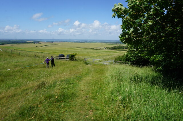
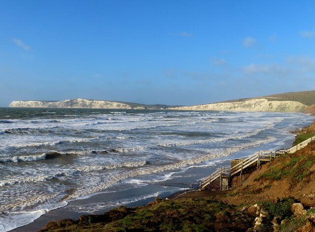
East Afton Down is a picturesque area located in the southwestern part of the Isle of Wight, Hampshire, England. Spanning over 200 hectares, it is characterized by its rolling hills, open grassland, and heathland, making it a beautiful example of downs and moorland habitat. The area is renowned for its stunning panoramic views of the surrounding countryside and coastline.

The downs of East Afton Down are covered in short grasses and scattered with gorse and heather, creating a vibrant and colorful landscape, particularly during the summer months. The area is also home to a variety of wildlife, including rabbits, lizards, and a wide range of bird species. It is a popular spot for birdwatching enthusiasts, who can observe species such as kestrels, skylarks, and the occasional peregrine falcon.

East Afton Down has a rich history, with evidence of human activity dating back thousands of years. The Bronze Age burial mounds found in the area are a testament to its ancient past. The downland was also used for grazing livestock and as a training ground for the military during World War II.

Today, East Afton Down is a popular destination for outdoor enthusiasts and nature lovers. The area offers numerous walking trails that allow visitors to explore its diverse landscape at their own pace. The breathtaking views, tranquil atmosphere, and abundance of wildlife make it an ideal location for relaxation and exploration.

If you have any feedback on the listing, please let us know in the comments section below.

East Afton Down Images

Images are sourced within 2km of 50.671109/-1.4835069 or Grid Reference SZ3685. Thanks to Geograph Open Source API. All images are credited.

Climbing up from Compton Beach – 1978 Not the best of weather for an open-top bus trip, this was a special hire by a group of bus enthusiasts visiting the island.

Southern Vectis 702 is a Bristol K with ECW bodywork, new to the company in 1939 and converted for open top services in 1959. When this view was taken she was already approaching her 40th year of service with the company, and although seen here on a private charter, was still regularly used on normal services. In 2021, now affectionately called 'The Old Girl', she is still in service, although now only used for special private charter work. As such, she holds the UK, and possibly world, record for a bus in continuous service with the same operator.

This is one of a series of views featuring buses in the 60s, 70s, and 80s. <a title="https://www.geograph.org.uk/search.php?i=137652761" href="https://www.geograph.org.uk/search.php?i=137652761">Link</a>
Climbing up from Compton Beach – 1978
Not the best of weather for an open-top bus trip, this was a special hire by a group of bus enthusiasts visiting the island. Southern Vectis 702 is a Bristol K with ECW bodywork, new to the company in 1939 and converted for open top services in 1959. When this view was taken she was already approaching her 40th year of service with the company, and although seen here on a private charter, was still regularly used on normal services. In 2021, now affectionately called 'The Old Girl', she is still in service, although now only used for special private charter work. As such, she holds the UK, and possibly world, record for a bus in continuous service with the same operator. This is one of a series of views featuring buses in the 60s, 70s, and 80s. Link
Catching the breeze – 1978 A group of hardy bus enthusiasts enjoying a trip on a vintage open top bus climbing to the top of the cliffs just to the east of Freshwater.

Southern Vectis 702 is a Bristol K with ECW bodywork, new to the company in 1939 and converted for open top services in 1959. When this view was taken she was already approaching her 40th year of service with the company, and although seen here on a private charter, was still regularly used on normal services. In 2021, now affectionately called 'The Old Girl', she is still in service, although now only used for special private charter work. As such, she holds the UK, and possibly world, record for a bus in continuous service with the same operator.

This is one of a series of views featuring buses in the 60s, 70s, and 80s. <a title="https://www.geograph.org.uk/search.php?i=137652761" href="https://www.geograph.org.uk/search.php?i=137652761">Link</a>
Catching the breeze – 1978
A group of hardy bus enthusiasts enjoying a trip on a vintage open top bus climbing to the top of the cliffs just to the east of Freshwater. Southern Vectis 702 is a Bristol K with ECW bodywork, new to the company in 1939 and converted for open top services in 1959. When this view was taken she was already approaching her 40th year of service with the company, and although seen here on a private charter, was still regularly used on normal services. In 2021, now affectionately called 'The Old Girl', she is still in service, although now only used for special private charter work. As such, she holds the UK, and possibly world, record for a bus in continuous service with the same operator. This is one of a series of views featuring buses in the 60s, 70s, and 80s. Link
Site of the 1970 Isle of Wight Festival 50 years later View from East Afton Down towards East Afton Farm with the site in between. The photo was taken exactly 50 years after the first day of the Festival whose performers included Jimi Hendrix, The Doors, The Who, Ten Years After, Chicago, The Moody Blues, Joni Mitchell, Leonard Cohen, Jethro Tull and Supertramp.
Site of the 1970 Isle of Wight Festival 50 years later
View from East Afton Down towards East Afton Farm with the site in between. The photo was taken exactly 50 years after the first day of the Festival whose performers included Jimi Hendrix, The Doors, The Who, Ten Years After, Chicago, The Moody Blues, Joni Mitchell, Leonard Cohen, Jethro Tull and Supertramp.
Freshwater Bay Freshwater Bay has formed in a break in the chalk cliffs. The rocks shown here are at the SE corner of the bay, viewed from the promenade - Stag Rock, Arched Rock & Mermaid Rock (right to left). A cave is also visible. A fishing boat is moored. Photo taken in June or July 1973.  Arched Rock subsequently collapsed in 1992.
Freshwater Bay
Freshwater Bay has formed in a break in the chalk cliffs. The rocks shown here are at the SE corner of the bay, viewed from the promenade - Stag Rock, Arched Rock & Mermaid Rock (right to left). A cave is also visible. A fishing boat is moored. Photo taken in June or July 1973. Arched Rock subsequently collapsed in 1992.
The Tennyson Trail across Brook Down Offering wonderful views from the top of West Wight's chalkland spine, the Trail passes through the whole of the grid square en route to Tennyson Down.
The Tennyson Trail across Brook Down
Offering wonderful views from the top of West Wight's chalkland spine, the Trail passes through the whole of the grid square en route to Tennyson Down.
Grazing above Freshwater Bay
Bus terminus, Freshwater Bay – 1978 Southern Vectis was the principal operator on the island from the 1930s having come under control of the Southern Railway in 1929. By 1978 it was part of the National Bus Company. Bus 673, a Bristol VR with ECW bodywork, is seen in the standard NBC livery of leaf green, and is representative of what was effectively the standard NBC double deck bus of the period. It is parked at the entrance to the Freshwater Bay Golf Club on Southdown Road waiting for its return to Sandown.

This is one of a series of views featuring buses in the 60s, 70s, and 80s. <a title="https://www.geograph.org.uk/search.php?i=137652761" href="https://www.geograph.org.uk/search.php?i=137652761">Link</a>
Bus terminus, Freshwater Bay – 1978
Southern Vectis was the principal operator on the island from the 1930s having come under control of the Southern Railway in 1929. By 1978 it was part of the National Bus Company. Bus 673, a Bristol VR with ECW bodywork, is seen in the standard NBC livery of leaf green, and is representative of what was effectively the standard NBC double deck bus of the period. It is parked at the entrance to the Freshwater Bay Golf Club on Southdown Road waiting for its return to Sandown. This is one of a series of views featuring buses in the 60s, 70s, and 80s. Link
Sunset seen from Shippards Chine
View from Brook Down
Hamstead Trail towards Wellow
Freshwater Bay and Stag Rock
Compton Bay
Compton Bay
Compton Bay
Compton Bay
Compton Bay Looking along the beach at Compton Bay from the car park near Shippards Chine, with the change from chalk to sandstone in the cliffs clearly visible.
Compton Bay
Looking along the beach at Compton Bay from the car park near Shippards Chine, with the change from chalk to sandstone in the cliffs clearly visible.
Show me another place!

East Afton Down is located at Grid Ref: SZ3685 (Lat: 50.671109, Lng: -1.4835069)

Unitary Authority: Isle of Wight

Police Authority: Hampshire

What 3 Words

///thunder.rosette.confetti. Near Freshwater, Isle of Wight

Related Wikis

Compton Down

Compton Down is a hill on the Isle of Wight just to the east of Freshwater Bay. It is part of the chalk ridge which forms the "backbone" of the Isle of...

Isle of Wight Festival 1970

The Isle of Wight Festival 1970 was a music festival held between 26 and 31 August 1970 at Afton Down, an area on the western side of the Isle of Wight...

Compton Bay

Compton Bay is a bay located on the southwest section of the Isle of Wight, England. Its northwestern edge is defined by the distinctive white chalk cliff...

Afton Down

Afton Down is a chalk down near the village of Freshwater on the Isle of Wight. Afton Down faces Compton Bay directly to the west, while Freshwater is...

Afton Park

Afton Park is a settlement on the Isle of Wight, off the south coast of England. The hamlet lies to the east of the A3055 road, near to the larger settlement...

Afton, Isle of Wight

Afton is a hamlet just outside Freshwater on the west side of the Isle of Wight. It features a local hill known as Afton Down which was the site of the...

Freshwater Bay Independent Lifeboat Station

Freshwater Lifeboat Station is owned and operated by the Freshwater Independent Lifeboat Service located in the village of Freshwater on the Isle of Wight...

Prospect Quarry

Prospect Quarry is a 4.3-hectare (11-acre) Site of special scientific interest which is located north-west of the village of Shalcombe located close to...

Nearby Amenities

Located within 500m of 50.671109,-1.4835069
Source: Bing
Lat/Long: 50.6666625/-1.4839862
Source: Bing
Lat/Long: 50.666818/-1.4845038
Source: Bing
Lat/Long: 50.6691345/-1.488853
Barrier: stile
Foot: yes
Lat/Long: 50.6670604/-1.4830533
Source: Bing
Lat/Long: 50.6685861/-1.4874803
Bench
Lat/Long: 50.6669099/-1.4830173
Compton Down
Note: os shows a 'down' as the historical slope. rather than the summit of a hill
Place: locality
Source: os 1.25k
Lat/Long: 50.6684798/-1.4808025
East Afton Down
Note: os shows a 'down' as the historical slope. rather than the summit of a hill
Place: locality
Source: OS 1:25k
Lat/Long: 50.6711793/-1.4827444
Hiking: yes
Information: guidepost
Tourism: information
Lat/Long: 50.667095/-1.4829558
Barrier: stile
Foot: yes
Lat/Long: 50.6722012/-1.4795441
6
Golf: pin
Lat/Long: 50.6703488/-1.4878508
7
Golf: pin
Lat/Long: 50.6701924/-1.4824703
10
Golf: pin
Lat/Long: 50.6700105/-1.4767867
8
Golf: pin
Lat/Long: 50.6700496/-1.4773071
11
Golf: pin
Lat/Long: 50.6698507/-1.481958
12
Golf: pin
Lat/Long: 50.669849/-1.4884906
Barrier: kissing_gate
Lat/Long: 50.6668327/-1.4828657
The data included in this document is from www.openstreetmap.org. The data is made available under ODbL.

Have you been to East Afton Down?

Leave your review of East Afton Down below (or comments, questions and feedback).