Harbury Fields

Downs, Moorland in Warwickshire Stratford-on-Avon

England

Harbury Fields

Chesterton Mill A wintery sunset on Windmill Hill
Chesterton Mill Credit: Rod Davidson

Harbury Fields is a picturesque area located in the county of Warwickshire, England. Situated between the Downs and the Moorland, it offers a diverse landscape that attracts both locals and tourists alike.

The Downs of Harbury Fields are characterized by rolling hills covered in vibrant green grass. These hills provide a perfect setting for leisurely walks, picnics, or even a spot of kite flying. The views from the top of the Downs are breathtaking, overlooking the surrounding countryside and offering glimpses of nearby villages.

On the other hand, the Moorland of Harbury Fields presents a more rugged and wild terrain. Here, visitors can explore vast expanses of heather-covered moors, interspersed with glistening ponds and small streams. The Moorland is known for its unique flora and fauna, with rare species of birds and plants making their home in this untouched ecosystem.

The area surrounding Harbury Fields is also steeped in history. Nearby, you will find the ancient Harbury village, with its charming thatched cottages and old-world charm. The village boasts a rich heritage, with remnants of its Norman roots evident in the historic buildings and churches.

For those seeking outdoor activities, Harbury Fields offers a range of options. The Downs are perfect for hiking and cycling, with well-maintained trails catering to all levels of fitness. The Moorland, on the other hand, provides opportunities for birdwatching, nature photography, and even horseback riding.

In conclusion, Harbury Fields in Warwickshire is a captivating destination that combines the beauty of the Downs with the untamed allure of the Moorland. With its natural landscapes, rich history, and outdoor activities, it is a must-visit for anyone looking to immerse themselves in the beauty of the English countryside.

If you have any feedback on the listing, please let us know in the comments section below.

Harbury Fields Images

Images are sourced within 2km of 52.244583/-1.4827134 or Grid Reference SP3560. Thanks to Geograph Open Source API. All images are credited.

Chesterton Mill A wintery sunset on Windmill Hill
Chesterton Mill
A wintery sunset on Windmill Hill
Harbury, Temple End
Harbury, Temple End
Temple End, Harbury
Temple End, Harbury
Chesterton Road
Chesterton Road
Chesterton Windmill Grade I-listed windmill, dating from 1682 (Historic England List Entry Number:1300056 <span class="nowrap"><a title="https://historicengland.org.uk/listing/the-list/list-entry/1300056?section=official-list-entry" rel="nofollow ugc noopener" href="https://historicengland.org.uk/listing/the-list/list-entry/1300056?section=official-list-entry">Link</a><img style="margin-left:2px;" alt="External link" title="External link - shift click to open in new window" src="https://s1.geograph.org.uk/img/external.png" width="10" height="10"/></span> ); it was associated with Chesterton House which was demolished in 1802. The current machinery dates from 1860 and was used until about 1910 before gradually becoming derelict. The mill was restored to working order between 1965 and 1974 and is now owned by Warwickshire County Council.

The windmill no longer has its sails, see <a href="https://www.geograph.org.uk/photo/4950975">SP3459 : Chesterton Windmill</a> for an earlier (2016) photograph complete with its sails.
Chesterton Windmill
Grade I-listed windmill, dating from 1682 (Historic England List Entry Number:1300056 LinkExternal link ); it was associated with Chesterton House which was demolished in 1802. The current machinery dates from 1860 and was used until about 1910 before gradually becoming derelict. The mill was restored to working order between 1965 and 1974 and is now owned by Warwickshire County Council. The windmill no longer has its sails, see SP3459 : Chesterton Windmill for an earlier (2016) photograph complete with its sails.
Windmill Hill Lane, Chesterton Green
Chesterton Windmill and Windmill Hill The picture was taken over a field gate during a sunny spell early on a showery April evening. The limestone tower dates from 1632 - for more about it, try <span class="nowrap"><a title="http://www2.warwick.ac.uk/fac/sci/moac/people/students/peter_cock/photos/chesterton_windmill/" rel="nofollow ugc noopener" href="http://www2.warwick.ac.uk/fac/sci/moac/people/students/peter_cock/photos/chesterton_windmill/">Link</a><img style="margin-left:2px;" alt="External link" title="External link - shift click to open in new window" src="https://s1.geograph.org.uk/img/external.png" width="10" height="10"/></span> .
Chesterton Windmill and Windmill Hill
The picture was taken over a field gate during a sunny spell early on a showery April evening. The limestone tower dates from 1632 - for more about it, try LinkExternal link .
Chesterton Windmill The picture was taken over a field gate during a sunny spell early on a showery April evening. The limestone tower dates from 1632 - for more about it, try <span class="nowrap"><a title="http://www2.warwick.ac.uk/fac/sci/moac/people/students/peter_cock/photos/chesterton_windmill/" rel="nofollow ugc noopener" href="http://www2.warwick.ac.uk/fac/sci/moac/people/students/peter_cock/photos/chesterton_windmill/">Link</a><img style="margin-left:2px;" alt="External link" title="External link - shift click to open in new window" src="https://s1.geograph.org.uk/img/external.png" width="10" height="10"/></span> .
Chesterton Windmill
The picture was taken over a field gate during a sunny spell early on a showery April evening. The limestone tower dates from 1632 - for more about it, try LinkExternal link .
Up Windmill Hill South Warwickshire early on an April evening.
Up Windmill Hill
South Warwickshire early on an April evening.
Farmland on Windmill Hill
Chesterton Windmill Unusual early windmill constructed in 1632. Open in 2016 for National Mills Weekend but light winds prevented any milling.
Chesterton Windmill
Unusual early windmill constructed in 1632. Open in 2016 for National Mills Weekend but light winds prevented any milling.
Chesterton Mill - Inside the Cap/Dust Floor The working parts of the power system comprise the wind shaft, attached to the sails, fixed to the toothed brake wheel which in turn transfers the drive to the main vertical shaft through the lantern gallery. The top of the main shaft is held in position by the Sprattle Beam.

The mill was open to the public for National Mills Weekend 2016.
Chesterton Mill - Inside the Cap/Dust Floor
The working parts of the power system comprise the wind shaft, attached to the sails, fixed to the toothed brake wheel which in turn transfers the drive to the main vertical shaft through the lantern gallery. The top of the main shaft is held in position by the Sprattle Beam. The mill was open to the public for National Mills Weekend 2016.
Chesterton Mill - Stone Floor The mill has two pairs of stones set on the Hurst or wooden frame about one metre above the floor level. The Spur Wheel and Stone Nuts occupy the space below. The flour is also collected just below the wooden Tun that encases the stones.
Chesterton Mill - Stone Floor
The mill has two pairs of stones set on the Hurst or wooden frame about one metre above the floor level. The Spur Wheel and Stone Nuts occupy the space below. The flour is also collected just below the wooden Tun that encases the stones.
Chesterton Mill - Cap winch The winch allows the whole of the cap, sails and wind shaft to be manually turned into the wind. The wind direction is shown on an indicator at the top of the cap connected to an external weather vane. Later mills incorporated a tail wheel to automatically adjust for wind direction.
Chesterton Mill - Cap winch
The winch allows the whole of the cap, sails and wind shaft to be manually turned into the wind. The wind direction is shown on an indicator at the top of the cap connected to an external weather vane. Later mills incorporated a tail wheel to automatically adjust for wind direction.
Chesterton Mill - Wind direction indicator The whole of the cap, sails and wind shaft had to be manually turned into the wind using a winch. The wind direction is shown on an indicator at the top of the cap connected to an external weather vane. Later mills incorporated a tail wheel to automatically adjust for wind direction.
Chesterton Mill - Wind direction indicator
The whole of the cap, sails and wind shaft had to be manually turned into the wind using a winch. The wind direction is shown on an indicator at the top of the cap connected to an external weather vane. Later mills incorporated a tail wheel to automatically adjust for wind direction.
Chesterton Mill - Lantern Pinion Wallower Unusual detail on the top of the Main Shaft. Normally this would be a toothed wheel.
Chesterton Mill - Lantern Pinion Wallower
Unusual detail on the top of the Main Shaft. Normally this would be a toothed wheel.
Chesterton Mill - Ground Level The mill is raised off the ground on six columns with connecting arches. Stairs give access directly to the Stone Floor. Until 1930 there was a square timber structure from ground level to the underside of the Stone Floor used for grain storage but removed to prevent vandalism.
Chesterton Mill - Ground Level
The mill is raised off the ground on six columns with connecting arches. Stairs give access directly to the Stone Floor. Until 1930 there was a square timber structure from ground level to the underside of the Stone Floor used for grain storage but removed to prevent vandalism.
Footpath to Chesterton Windmill The mill was open to the public for National Mills Weekend 2016.
Footpath to Chesterton Windmill
The mill was open to the public for National Mills Weekend 2016.
Show me another place!

Harbury Fields is located at Grid Ref: SP3560 (Lat: 52.244583, Lng: -1.4827134)

Administrative County: Warwickshire

District: Stratford-on-Avon

Police Authority: Warwickshire

What 3 Words

///printout.fairy.served. Near Harbury, Warwickshire

Nearby Locations

Harbury Fields

Related Wikis

Leamington F.C.

Leamington Football Club is a football club based in Leamington Spa, Warwickshire, England. They are currently members of the Southern League Premier Division...
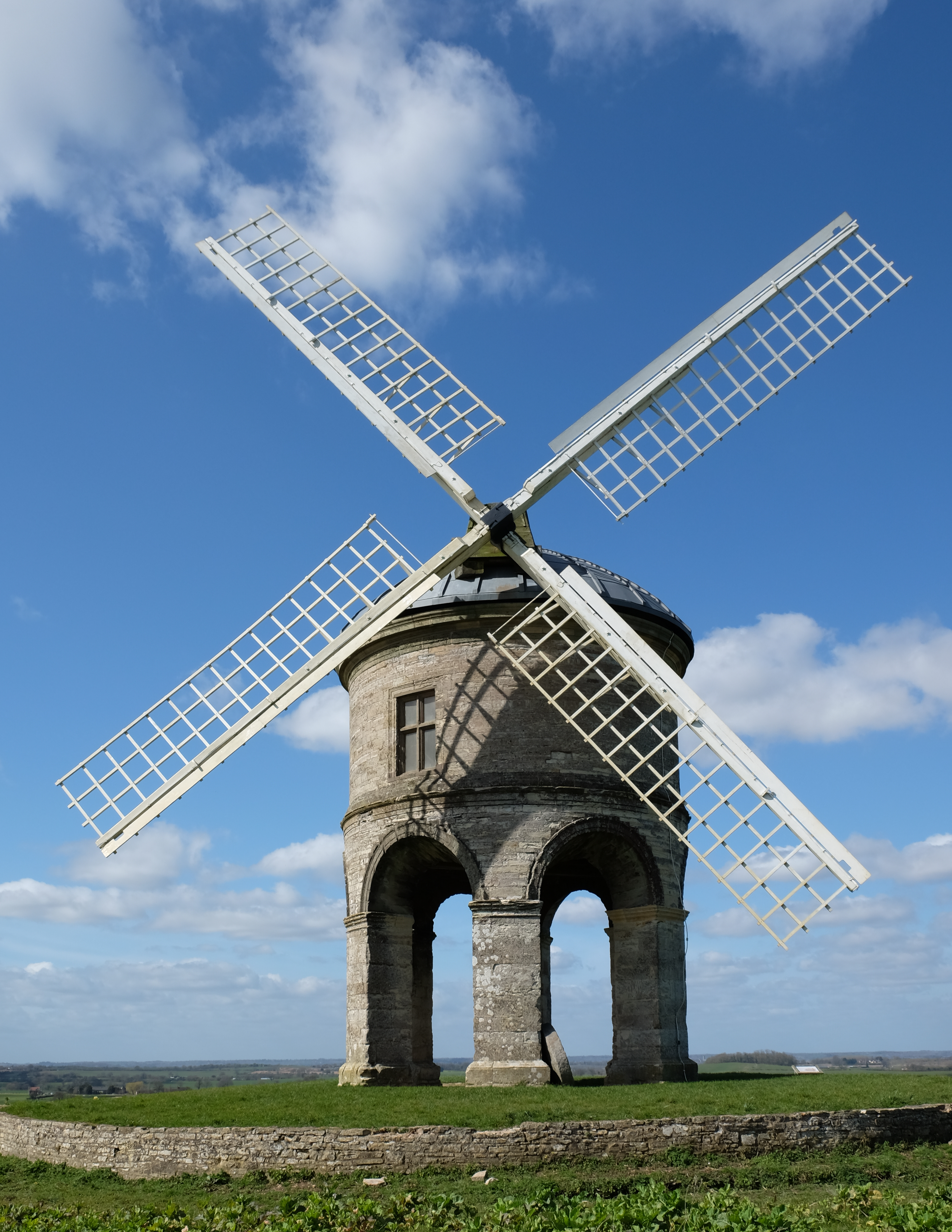
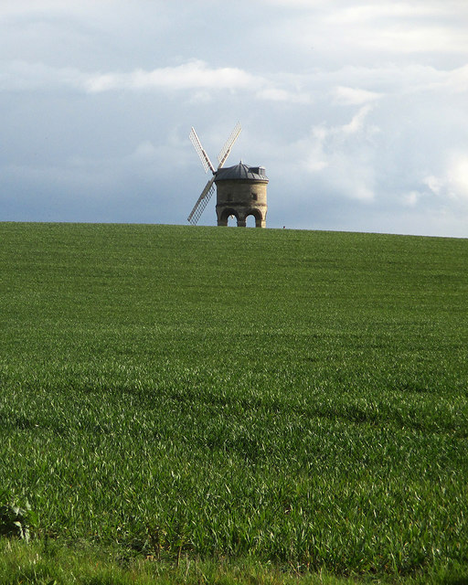
Chesterton Windmill

Chesterton Windmill is a 17th-century cylindric stone tower windmill with an arched base, located outside the village of Chesterton, Warwickshire. It is...
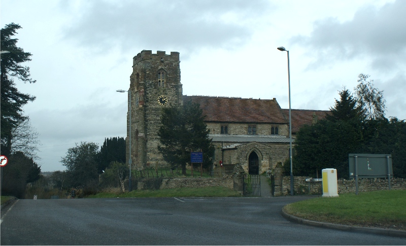
Harbury

Harbury is a village and civil parish in the Stratford-on-Avon district of Warwickshire, England. It is about 3 miles (5 km) west-southwest of Southam...

Chesterton, Warwickshire

Chesterton is a small village in Warwickshire, England. The population of the civil parish taken at the 2011 census was 123. It is about five miles south...

Ufton Fields

Ufton Fields is a biological Site of Special Scientific Interest and local nature reserve in Warwickshire, England. It is situated on the A425 close to...

Warwick services

Warwick Services is a motorway service station on the M40 motorway in Warwickshire, England. It is situated approximately 5 miles (8 km) south-east of...

Ufton

Ufton is a small village and civil parish in the Stratford-on-Avon District of Warwickshire, England. The population taken from the 2011 census was 319...

Southam Road and Harbury railway station

Southam Road and Harbury railway station was a railway station, located 1 mile (1.6 km) east of Harbury, and 2.5 miles (4.0 km) south-west of Southam,...

Nearby Amenities

Located within 500m of 52.244583,-1.4827134
Bus Stop
Harbury Field Cottages
Bench: no
Bin: no
Bus: yes
Covered: no
Lit: no
Naptan AtcoCode: 4200F148791
Naptan Bearing: W
Naptan CommonName: Harbury Field Cottages
Naptan Indicator: Adj
Naptan NaptanCode: wardjdgt
Naptan Street: Middle Road
Naptan Verified: no
Passenger Information Display: no
Public Transport: platform
Shelter: no
Source: naptan_import
Tactile Paving: no
Lat/Long: 52.245236/-1.4853872
Bus Stop
Harbury Fields Cottages
Bench: no
Bin: no
Bus: yes
Covered: no
Lit: no
Naptan AtcoCode: 4200F148792
Naptan Bearing: E
Naptan CommonName: Harbury Fields Cottages
Naptan Indicator: Opp
Naptan NaptanCode: wardjdgw
Naptan Street: Middle Road
Naptan Verified: no
Passenger Information Display: no
Public Transport: platform
Shelter: no
Source: naptan_import
Tactile Paving: no
Lat/Long: 52.2453526/-1.4853126
Man Made: mast
Tower Type: communication
Lat/Long: 52.2478278/-1.4864011
Brand: National Grid
Brand Wikidata: Q1465461
Material: wood
Operator: National Grid Electricity Distribution
Operator Old: Western Power Distribution
Operator Wikidata: Q7988183
Owner: National Grid Electricity Distribution (East Midlands) Plc
Owner Wikidata: Q114348127
Power: pole
Lat/Long: 52.2443856/-1.4886436
Brand: National Grid
Brand Wikidata: Q1465461
Material: wood
Operator: National Grid Electricity Distribution
Operator Old: Western Power Distribution
Operator Wikidata: Q7988183
Owner: National Grid Electricity Distribution (East Midlands) Plc
Owner Wikidata: Q114348127
Power: pole
Lat/Long: 52.2438223/-1.4875558
Brand: National Grid
Brand Wikidata: Q1465461
Material: wood
Operator: National Grid Electricity Distribution
Operator Old: Western Power Distribution
Operator Wikidata: Q7988183
Owner: National Grid Electricity Distribution (East Midlands) Plc
Owner Wikidata: Q114348127
Power: pole
Lat/Long: 52.2432976/-1.4865366
Brand: National Grid
Brand Wikidata: Q1465461
Material: wood
Operator: National Grid Electricity Distribution
Operator Old: Western Power Distribution
Operator Wikidata: Q7988183
Owner: National Grid Electricity Distribution (East Midlands) Plc
Owner Wikidata: Q114348127
Power: pole
Lat/Long: 52.2425937/-1.485228
Brand: National Grid
Brand Wikidata: Q1465461
Material: wood
Operator: National Grid Electricity Distribution
Operator Old: Western Power Distribution
Operator Wikidata: Q7988183
Owner: National Grid Electricity Distribution (East Midlands) Plc
Owner Wikidata: Q114348127
Power: pole
Lat/Long: 52.2419064/-1.4838925
Brand: National Grid
Brand Wikidata: Q1465461
Material: wood
Operator: National Grid Electricity Distribution
Operator Old: Western Power Distribution
Operator Wikidata: Q7988183
Owner: National Grid Electricity Distribution (East Midlands) Plc
Owner Wikidata: Q114348127
Power: pole
Lat/Long: 52.2412197/-1.4825478
Brand: National Grid
Brand Wikidata: Q1465461
Material: wood
Operator: National Grid Electricity Distribution
Operator Old: Western Power Distribution
Operator Wikidata: Q7988183
Owner: National Grid Electricity Distribution (East Midlands) Plc
Owner Wikidata: Q114348127
Power: pole
Lat/Long: 52.2406085/-1.4813544
Brand: National Grid
Brand Wikidata: Q1465461
Frequency: 50
Material: wood
Operator: National Grid Electricity Distribution
Operator Old: Western Power Distribution
Operator Wikidata: Q7988183
Owner: National Grid Electricity Distribution (East Midlands) Plc
Owner Wikidata: Q114348127
Power: pole
Ref: 932896
Source: wpd_opendata
Transformer: distribution
Lat/Long: 52.2466884/-1.4848958
Brand: National Grid
Brand Wikidata: Q1465461
Line Management: branch
Material: wood
Operator: National Grid Electricity Distribution
Operator Old: Western Power Distribution
Operator Wikidata: Q7988183
Owner: National Grid Electricity Distribution (East Midlands) Plc
Owner Wikidata: Q114348127
Power: pole
Source: Warwicks CC Aerial Imagery 2013
Lat/Long: 52.2469394/-1.4862483
Brand: National Grid
Brand Wikidata: Q1465461
Material: wood
Operator: National Grid Electricity Distribution
Operator Old: Western Power Distribution
Operator Wikidata: Q7988183
Owner: National Grid Electricity Distribution (East Midlands) Plc
Owner Wikidata: Q114348127
Power: pole
Lat/Long: 52.2438459/-1.4890842
Brand: National Grid
Brand Wikidata: Q1465461
Material: wood
Operator: National Grid Electricity Distribution
Operator Old: Western Power Distribution
Operator Wikidata: Q7988183
Owner: National Grid Electricity Distribution (East Midlands) Plc
Owner Wikidata: Q114348127
Power: pole
Lat/Long: 52.2447524/-1.488723
Brand: National Grid
Brand Wikidata: Q1465461
Material: wood
Operator: National Grid Electricity Distribution
Operator Old: Western Power Distribution
Operator Wikidata: Q7988183
Owner: National Grid Electricity Distribution (East Midlands) Plc
Owner Wikidata: Q114348127
Power: pole
Lat/Long: 52.2454272/-1.4878117
Brand: National Grid
Brand Wikidata: Q1465461
Material: wood
Operator: National Grid Electricity Distribution
Operator Old: Western Power Distribution
Operator Wikidata: Q7988183
Owner: National Grid Electricity Distribution (East Midlands) Plc
Owner Wikidata: Q114348127
Power: pole
Lat/Long: 52.2461928/-1.4869843
Marker: yes
Pipeline: marker
Source: survey
Substance: gas
Utility: gas
Lat/Long: 52.2443067/-1.4812647
Brand: National Grid
Brand Wikidata: Q1465461
Material: wood
Operator: National Grid Electricity Distribution
Operator Old: Western Power Distribution
Operator Wikidata: Q7988183
Owner: National Grid Electricity Distribution (East Midlands) Plc
Owner Wikidata: Q114348127
Power: pole
Lat/Long: 52.2474972/-1.4882878
Brand: National Grid
Brand Wikidata: Q1465461
Material: wood
Operator: National Grid Electricity Distribution
Operator Old: Western Power Distribution
Operator Wikidata: Q7988183
Owner: National Grid Electricity Distribution (East Midlands) Plc
Owner Wikidata: Q114348127
Power: pole
Lat/Long: 52.2469186/-1.4875393
Brand: National Grid
Brand Wikidata: Q1465461
Material: wood
Operator: National Grid Electricity Distribution
Operator Old: Western Power Distribution
Operator Wikidata: Q7988183
Owner: National Grid Electricity Distribution (East Midlands) Plc
Owner Wikidata: Q114348127
Power: pole
Lat/Long: 52.2453962/-1.485061
Brand: National Grid
Brand Wikidata: Q1465461
Material: wood
Operator: National Grid Electricity Distribution
Operator Old: Western Power Distribution
Operator Wikidata: Q7988183
Owner: National Grid Electricity Distribution (East Midlands) Plc
Owner Wikidata: Q114348127
Power: pole
Lat/Long: 52.2459004/-1.4849738
Brand: National Grid
Brand Wikidata: Q1465461
Material: wood
Operator: National Grid Electricity Distribution
Operator Old: Western Power Distribution
Operator Wikidata: Q7988183
Owner: National Grid Electricity Distribution (East Midlands) Plc
Owner Wikidata: Q114348127
Power: pole
Lat/Long: 52.246274/-1.4848142
Brand: National Grid
Brand Wikidata: Q1465461
Material: wood
Operator: National Grid Electricity Distribution
Operator Old: Western Power Distribution
Operator Wikidata: Q7988183
Owner: National Grid Electricity Distribution (East Midlands) Plc
Owner Wikidata: Q114348127
Power: pole
Lat/Long: 52.2466941/-1.4843116
Man Made: utility_pole
Material: wood
Lat/Long: 52.2439725/-1.4857406
Man Made: utility_pole
Material: wood
Lat/Long: 52.2443993/-1.4852864
Man Made: utility_pole
Material: wood
Lat/Long: 52.2446847/-1.4850523
Man Made: utility_pole
Material: wood
Lat/Long: 52.2435687/-1.4862727
Man Made: utility_pole
Material: wood
Lat/Long: 52.2431569/-1.4868027
Man Made: utility_pole
Material: wood
Lat/Long: 52.242831/-1.4870498
Man Made: utility_pole
Material: wood
Lat/Long: 52.2424992/-1.4871874
Man Made: utility_pole
Material: wood
Lat/Long: 52.2414586/-1.4876762
Man Made: utility_pole
Material: wood
Lat/Long: 52.2420361/-1.4874008
Man Made: utility_pole
Material: wood
Lat/Long: 52.2450432/-1.4843456
Man Made: utility_pole
Material: wood
Lat/Long: 52.2448738/-1.4835354
Man Made: utility_pole
Material: wood
Lat/Long: 52.2452011/-1.4838465
Man Made: utility_pole
Material: wood
Lat/Long: 52.2456872/-1.4837987
Man Made: utility_pole
Material: wood
Lat/Long: 52.246157/-1.4836951
Brand: National Grid
Brand Wikidata: Q1465461
Material: wood
Operator: National Grid Electricity Distribution
Operator Old: Western Power Distribution
Operator Wikidata: Q7988183
Owner: National Grid Electricity Distribution (East Midlands) Plc
Owner Wikidata: Q114348127
Power: pole
Lat/Long: 52.2431857/-1.4896191
Marker: yes
Pipeline: marker
Source: survey
Substance: gas
Utility: gas
Lat/Long: 52.2444547/-1.4810325
The data included in this document is from www.openstreetmap.org. The data is made available under ODbL.

Have you been to Harbury Fields?

Leave your review of Harbury Fields below (or comments, questions and feedback).