Rockmoor Down

Downs, Moorland in Wiltshire

England

Rockmoor Down

Bridleway at the bend The road makes a sharp right but walkers and riders have a choice.
Bridleway at the bend Credit: Des Blenkinsopp

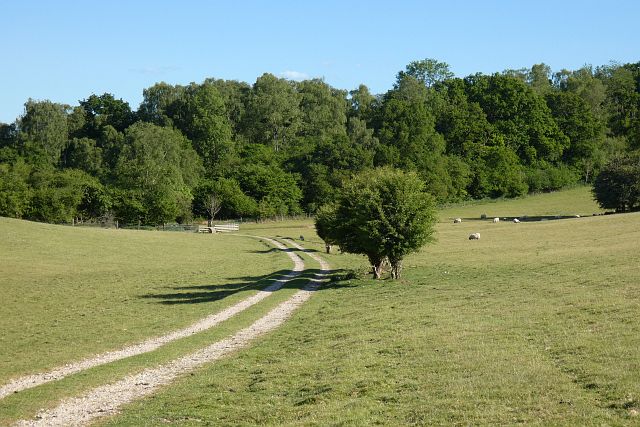
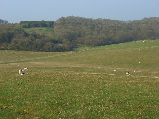
Rockmoor Down is a picturesque area located in Wiltshire, England, known for its stunning combination of downs and moorland landscapes. Situated in the southern part of the county, it covers an extensive area of approximately 5 square kilometers. The terrain consists of rolling hills, steep slopes, and vast open spaces, offering breathtaking panoramic views.

The area is characterized by its unique geological features, dominated by chalk formations and dense layers of clay and flint. This diverse topography supports a wide variety of vegetation, including heather, gorse, bracken, and grasses, creating a rich and vibrant ecosystem. The downland areas are particularly renowned for their wildflower displays during the summer months, attracting nature enthusiasts and photographers alike.

Rockmoor Down is also home to a diverse array of wildlife. It provides habitats for various bird species, such as skylarks, meadow pipits, and stonechats. The moorland areas support small mammals like rabbits and hares, while the surrounding woodlands harbor deer and foxes. The area is also known for its butterfly population, with species like the chalkhill blue and marbled white frequently spotted.

The beauty and tranquility of Rockmoor Down make it a popular destination for outdoor activities, including hiking, birdwatching, and nature walks. Several well-maintained footpaths and trails meander through the area, offering visitors the opportunity to explore its natural wonders. Additionally, the downland's gentle slopes make it a prime location for paragliding and kite flying.

In summary, Rockmoor Down, Wiltshire is a captivating region renowned for its stunning downs and moorland landscapes, diverse flora and fauna, and a host of outdoor activities for nature enthusiasts.

If you have any feedback on the listing, please let us know in the comments section below.

Rockmoor Down Images

Images are sourced within 2km of 51.334165/-1.5021771 or Grid Reference SU3459. Thanks to Geograph Open Source API. All images are credited.

Bridleway at the bend The road makes a sharp right but walkers and riders have a choice.
Bridleway at the bend
The road makes a sharp right but walkers and riders have a choice.
Farmland, Linkenholt There was a surprisingly large amount of stubble in the vicinity given the time of year.
Farmland, Linkenholt
There was a surprisingly large amount of stubble in the vicinity given the time of year.
Pumping Station beyond Linkenholt Seen in <a href="https://www.geograph.org.uk/gridref/SU3658">SU3658</a> and <a title="https://www.geograph.org.uk/gridref/SU%20364%20589/links" href="https://www.geograph.org.uk/gridref/SU%20364%20589/links">Link</a>
Pumping Station beyond Linkenholt
Seen in SU3658 and Link
Isolated Cottage beyond Linkenholt Visible on the 1873 OS map. The building extends back quite far. Seemed to be inhabited, although not absolutely sure. Perhaps a gamekeepers cottage.
Isolated Cottage beyond Linkenholt
Visible on the 1873 OS map. The building extends back quite far. Seemed to be inhabited, although not absolutely sure. Perhaps a gamekeepers cottage.
Farmland, Vernhams Dean A crop of wheat to the south of Heath Plantation.
Farmland, Vernhams Dean
A crop of wheat to the south of Heath Plantation.
Farmland, Buttermere A cereal crop and shallow dry valley to the west of Heath Lane.
Farmland, Buttermere
A cereal crop and shallow dry valley to the west of Heath Lane.
Track and farmland, Linkenholt Fields of wheat to the south of Limber Copse and the county boundary.
Track and farmland, Linkenholt
Fields of wheat to the south of Limber Copse and the county boundary.
Pasture, Buttermere A bridleway approaching the junction of paths below Rockmoor Down.
Pasture, Buttermere
A bridleway approaching the junction of paths below Rockmoor Down.
Farmland, Vernhams Dean A permitted footpath follows the edge of this field of barley to the east of Upper Horns Farm.
Farmland, Vernhams Dean
A permitted footpath follows the edge of this field of barley to the east of Upper Horns Farm.
Littledown Methodist Chapel Erected in 1845.  Now in the process of conversion.
Littledown Methodist Chapel
Erected in 1845. Now in the process of conversion.
A junction sign in Hampshire I could not resist this shot, as neither Buttermere nor Henley are the ones that would come to the minds of most people!  And interestingly, although the sign is in Hampshire, both hamlets are in Wiltshire.
A junction sign in Hampshire
I could not resist this shot, as neither Buttermere nor Henley are the ones that would come to the minds of most people! And interestingly, although the sign is in Hampshire, both hamlets are in Wiltshire.
Fields near Upper Horns Farm
Timber from Buttermere Wood
The track to Vernham Dean At the crossroads just behind the photographer, the arms of the signpost point north, east, south (this track) and west. But only north and east are on surfaced roads. It would be unwise to take a normal car south or west!
The track to Vernham Dean
At the crossroads just behind the photographer, the arms of the signpost point north, east, south (this track) and west. But only north and east are on surfaced roads. It would be unwise to take a normal car south or west!
Junction in Littledown
In Littledown village
Descending the Test Way Approaching a crossroads of paths with the Test Way continuing to the left at the foot of this hill.
Descending the Test Way
Approaching a crossroads of paths with the Test Way continuing to the left at the foot of this hill.
Path crossroads on the Test Way
Show me another place!

Rockmoor Down is located at Grid Ref: SU3459 (Lat: 51.334165, Lng: -1.5021771)

Unitary Authority: Wiltshire

Police Authority: Wiltshire

What 3 Words

///snacks.defeat.airfields. Near Shalbourne, Wiltshire

Related Wikis

Combe Wood and Linkenholt Hanging

Combe Wood and Linkenholt Hanging is a 106.5-hectare (263-acre) biological Site of Special Scientific Interest south of Hungerford in Berkshire. It is...

Little Down

Little Down (or Littledown) is a village in Hampshire, England, on the North Downs near the county boundaries with Berkshire and Wiltshire. It lies just...

Buttermere, Wiltshire

Buttermere is a small village and civil parish on the eastern boundary of Wiltshire, England, about 4.5 miles (7 km) south of Hungerford and 10 miles...

Vernham Street

Vernham Street is a small village in the civil parish of Vernhams Dean situated in the North Wessex Downs Area of Outstanding Natural Beauty in the Test...

Linkenholt

Linkenholt is a village near Andover in Hampshire, England with about 40 inhabitants. It is in the civil Parish of Faccombe. The Domesday Book of 1086...

Inkpen Hill

Inkpen Hill is a summit in Berkshire, England, with a maximum elevation of 291 m (955 ft). The hill is about 7 miles (11 km) southwest of Newbury on the...

Ham Hill, Wiltshire

Ham Hill is a hill and area of chalk downland in Wiltshire, England, on the steep banks running alongside the road from the village of Ham to Buttermere...

Combe, Berkshire

Combe is a village and civil parish in the English county of Berkshire. The parish is situated on the top of the North Hampshire Downs near Walbury Hill...

Nearby Amenities

Located within 500m of 51.334165,-1.5021771
Rockmoor Down
Ele: 744 ft
Place: locality
Lat/Long: 51.3355064/-1.5063496
Ele: 233.5
Lat/Long: 51.3332943/-1.5065212
The data included in this document is from www.openstreetmap.org. The data is made available under ODbL.

Have you been to Rockmoor Down?

Leave your review of Rockmoor Down below (or comments, questions and feedback).