The Common

Downs, Moorland in Yorkshire

England

The Common

Dumb Steeple Possible boundary marker for the Beaumont Estate or another eye-catcher in their former Whitley Park
Dumb Steeple Credit: Kevin Waterhouse

The Common, Yorkshire is a picturesque region located in the northern part of England, known for its stunning landscapes and diverse natural beauty. The area encompasses vast stretches of open land, including downs and moorland, making it a haven for outdoor enthusiasts and nature lovers.

The Common is characterized by its rolling hills, heather-covered moors, and expansive grasslands. The downs, also known as uplands, offer panoramic views of the surrounding countryside, with their gentle slopes and lush greenery. These areas are particularly popular for walking, hiking, and birdwatching, attracting visitors from all over.

The moorland in The Common is a unique feature of the region, with its distinctive flora and fauna. The purple heather that blankets the moors during the summer months creates a stunning backdrop, while various species of birds, including the iconic red grouse, can be spotted in the area. The rugged terrain and peat bogs add to the charm of the moorland, making it an ideal destination for those seeking a remote and untamed landscape.

In addition to its natural beauty, The Common also boasts a rich cultural heritage. The area is dotted with charming villages and historic sites, such as ancient stone circles and prehistoric burial mounds, offering visitors a glimpse into the region's past.

Overall, The Common, Yorkshire, with its downs, moorland, and captivating scenery, provides an idyllic escape from the hustle and bustle of city life, offering visitors a chance to immerse themselves in nature and explore the rich history of the area.

If you have any feedback on the listing, please let us know in the comments section below.

The Common Images

Images are sourced within 2km of 53.629898/-1.6812635 or Grid Reference SE2114. Thanks to Geograph Open Source API. All images are credited.

Dumb Steeple Possible boundary marker for the Beaumont Estate or another eye-catcher in their former Whitley Park
Dumb Steeple
Possible boundary marker for the Beaumont Estate or another eye-catcher in their former Whitley Park
Old milestone On the A642 east of Grange Moor Traffic Island, where the Barnsley and Grange Moor turnpike (1759-1870) met the 27 mile long Wakefield and Austerlands first enacted in 1759.   But this is a milestone set up by the West Riding CC in 1893/94 hidden under the hedge.  It was dug up, painted and reset in 2010.  Grade II listed 1313334.
Old milestone
On the A642 east of Grange Moor Traffic Island, where the Barnsley and Grange Moor turnpike (1759-1870) met the 27 mile long Wakefield and Austerlands first enacted in 1759. But this is a milestone set up by the West Riding CC in 1893/94 hidden under the hedge. It was dug up, painted and reset in 2010. Grade II listed 1313334.
Old milestone Grass trampled down, another of over half of the 615 milestones still by the roadside that were set up by the family firm of F Stead and Son of Mirfield.   They won the contract from the newly formed West Riding County Council to set up these milestones all over the old West Riding in 1893/94.   The contract specified that the work must be done in 12 months and they achieved that.
Old milestone
Grass trampled down, another of over half of the 615 milestones still by the roadside that were set up by the family firm of F Stead and Son of Mirfield. They won the contract from the newly formed West Riding County Council to set up these milestones all over the old West Riding in 1893/94. The contract specified that the work must be done in 12 months and they achieved that.
Old milestone Prior to 2008 this is what the WRCC milestone, 9 miles from Wakefield, opposite the White Horse PH, now Bar 319, looked like.   It was uplifted by Kirklees Council together with the milestone a mile nearer Huddersfield.   It was repaired by having the whole of the left face replaced.   By 2012 it was set back up but at the Wakefield 10 mile point!
Old milestone
Prior to 2008 this is what the WRCC milestone, 9 miles from Wakefield, opposite the White Horse PH, now Bar 319, looked like. It was uplifted by Kirklees Council together with the milestone a mile nearer Huddersfield. It was repaired by having the whole of the left face replaced. By 2012 it was set back up but at the Wakefield 10 mile point!
Old milestone By 2012 the milestones Wakefield 9 and 10 were set back up.   This one had been very sunken and a mile nearer Huddersfield.   A new backing stone was made from a shaped coping stone from a wall top and is larger than the original.  The milestone is now leaning backwards slightly. This says Huddersfield 3¼ but there will be an extra mile to go if you are walking or cycling!   Grade II listed 1184132.
Old milestone
By 2012 the milestones Wakefield 9 and 10 were set back up. This one had been very sunken and a mile nearer Huddersfield. A new backing stone was made from a shaped coping stone from a wall top and is larger than the original. The milestone is now leaning backwards slightly. This says Huddersfield 3¼ but there will be an extra mile to go if you are walking or cycling! Grade II listed 1184132.
Old milestone Prior to 2008 this late 19thC West Riding CC milestone was on the southwest corner of Grange Moor roundabout near the pub.   In 2008 it was uplifted for refurbishment.
Old milestone
Prior to 2008 this late 19thC West Riding CC milestone was on the southwest corner of Grange Moor roundabout near the pub. In 2008 it was uplifted for refurbishment.
Old milestone By 2012 the West Riding CC milestone at Grange Moor TI at the junction of the A637 and A642 had been reset on the opposite side of the A637 which is the correct orientation for the legends.   A new backing stone had been fashioned from a wall coping stone.  In 2018 it had been knocked slightly sideways.  Fortunately no damage was done to the milestone.   Grade II listed 1313289.
Old milestone
By 2012 the West Riding CC milestone at Grange Moor TI at the junction of the A637 and A642 had been reset on the opposite side of the A637 which is the correct orientation for the legends. A new backing stone had been fashioned from a wall coping stone. In 2018 it had been knocked slightly sideways. Fortunately no damage was done to the milestone. Grade II listed 1313289.
Old milestone This shows the shape of the 'new' backing stone and how the milestone at Grange Moor roundabout has been pushed over slightly.   The holes would have, once upon a time, held railings.   Many were taken off for the war effort, 1939-45.   Grade II listed 1313289.
Old milestone
This shows the shape of the 'new' backing stone and how the milestone at Grange Moor roundabout has been pushed over slightly. The holes would have, once upon a time, held railings. Many were taken off for the war effort, 1939-45. Grade II listed 1313289.
Footpath on a farm track This track originally led to Grange Ash Colliery.
Footpath on a farm track
This track originally led to Grange Ash Colliery.
Houses on Wakefield Road, Grange Moor These houses are near the Kaye's Arms. They are not very noticeable when passed on the main road, but are easily seen from the footpath to the south.
Houses on Wakefield Road, Grange Moor
These houses are near the Kaye's Arms. They are not very noticeable when passed on the main road, but are easily seen from the footpath to the south.
The Kaye's Arms, Wakefield Road, Grange Moor
Footpath to Flockton Here the path is passing through the site of Grange Ash Colliery.
Footpath to Flockton
Here the path is passing through the site of Grange Ash Colliery.
Footpath from Denby Lane to Hill Farm, Grange Moor
Denby Lane, Grange Moor
Derelict building Been derelict for a few years now.
Derelict building
Been derelict for a few years now.
New village sign Not a sign for a new village, but a new sign for an old village.
New village sign
Not a sign for a new village, but a new sign for an old village.
Thorncliffe Social Club Walking the Emley Boundary Way.
Thorncliffe Social Club
Walking the Emley Boundary Way.
Near Cockermouth farm. Close to Cockermouth farm.
Near Cockermouth farm.
Close to Cockermouth farm.
Show me another place!

The Common is located at Grid Ref: SE2114 (Lat: 53.629898, Lng: -1.6812635)

Division: West Riding

Unitary Authority: Kirklees

Police Authority: West Yorkshire

What 3 Words

///harnessed.object.reef. Near Flockton, West Yorkshire

Related Wikis

Whitley Beaumont

Whitley Beaumont was an estate in the county of West Yorkshire, England, near Huddersfield. Whitley Hall (now demolished) was the seat of the Beaumont...

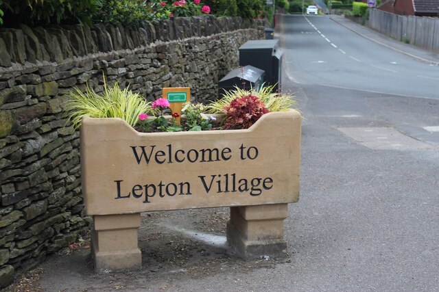
Lepton, West Yorkshire

Lepton is a village near Huddersfield in the parish of Kirkburton, in the Kirklees district of West Yorkshire, England. It is 4.25 miles (7 km) to the...

Shuttle Eye Colliery

Shuttle Eye Colliery was a coal mine on the South Yorkshire Coalfield at Grange Moor between Wakefield and Huddersfield on the A642 road, in England.The...

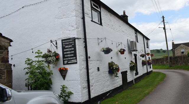
Thorncliffe, West Yorkshire

Thorncliffe (also marked on some maps as Thorncliff) is a hamlet in the civil parish of Kirkburton, in the Kirklees district, in the county of West Yorkshire...

Nearby Amenities

Located within 500m of 53.629898,-1.6812635
Bus Stop
Paul Lane Wakefield Road
Bench: no
Local Ref: 45020780
Naptan AtcoCode: 450020780
Naptan Bearing: S
Naptan CommonName: Paul Lane Wakefield Road
Naptan Crossing: Wakefield Road
Naptan Indicator: Stop 45020780
Naptan PlusbusZoneRef: LEEDS
Naptan ShortCommonName: Wakefield Road
Naptan Street: Paul Lane
Naptan Verified: no
Shelter: no
Source: naptan_import
Lat/Long: 53.6316171/-1.6768731
Bus Stop
Paul Lane Linfit Lane
Local Ref: 45020782
Naptan AtcoCode: 450020782
Naptan Bearing: NW
Naptan CommonName: Paul Lane Linfit Lane
Naptan Crossing: Linfit Lane
Naptan Indicator: Stop 45020782
Naptan PlusbusZoneRef: LEEDS
Naptan ShortCommonName: Linfit Lane
Naptan Street: Paul Lane
Naptan Verified: no
Source: naptan_import
Lat/Long: 53.6265568/-1.6762067
Bus Stop
Paul Lane Cockermouth Lane
Local Ref: 45025225
Naptan AtcoCode: 450025225
Naptan Bearing: SE
Naptan CommonName: Paul Lane Cockermouth Lane
Naptan Crossing: Cockermouth Lane
Naptan Indicator: Stop 45025225
Naptan Landmark: Dartmouth Arms PH
Naptan PlusbusZoneRef: LEEDS
Naptan ShortCommonName: Cockermouth Lane
Naptan Street: Paul Lane
Naptan Verified: no
Source: naptan_import
Lat/Long: 53.6276735/-1.6769996
Bus Stop
Paul Lane Wakefield Road
Naptan AtcoCode: 450028575
Naptan Bearing: N
Naptan CommonName: Paul Lane Wakefield Road
Naptan Crossing: Wakefield Road
Naptan Landmark: Unknown
Naptan PlusbusZoneRef: LEEDS
Naptan ShortCommonName: Wakefield Road
Naptan Street: Paul Lane
Naptan Verified: no
Source: naptan_import
Lat/Long: 53.6326714/-1.6770975
Paul Lane Dartmouth Arms PH
Local Ref: 45051521
Naptan AtcoCode: 450051521
Naptan Bearing: NW
Naptan BusStopType: CUS
Naptan CommonName: Paul Lane Dartmouth Arms PH
Naptan Indicator: Stop 45051521
Naptan PlusbusZoneRef: LEEDS
Naptan ShortCommonName: Paul Lane
Naptan Street: Paul Lane
Naptan Verified: no
Source: naptan_import
Lat/Long: 53.6276378/-1.6770906
Power: pole
Lat/Long: 53.6304498/-1.6878406
Power: pole
Lat/Long: 53.6306014/-1.6864236
Power: pole
Lat/Long: 53.6310688/-1.6858703
Power: pole
Lat/Long: 53.6316032/-1.6764051
Power: pole
Lat/Long: 53.631735/-1.6754595
Power: pole
Lat/Long: 53.6317772/-1.6850277
Power: pole
Lat/Long: 53.6317921/-1.6841557
Power: pole
Lat/Long: 53.6318021/-1.6832334
Power: pole
Lat/Long: 53.631807/-1.6822315
Power: pole
Lat/Long: 53.6318344/-1.6812883
Power: pole
Lat/Long: 53.6318405/-1.6746918
Power: pole
Lat/Long: 53.6320134/-1.6775824
Power: pole
Lat/Long: 53.6321849/-1.6781526
Power: pole
Lat/Long: 53.6322247/-1.6808523
Power: pole
Lat/Long: 53.6324708/-1.6786682
Power: pole
Lat/Long: 53.6326174/-1.6804498
Power: pole
Lat/Long: 53.6327939/-1.6792132
Power: pole
Lat/Long: 53.6330922/-1.679951
Power: pole
Lat/Long: 53.6330972/-1.6797581
The Common
Place: locality
Source: OS Historic
Lat/Long: 53.6293398/-1.6819611
Far Cockermouth
Place: locality
Source: OS Historic
Lat/Long: 53.6303669/-1.6742335
Shop: art
Source: survey
Lat/Long: 53.6277388/-1.6773953
Generator Method: wind_turbine
Generator Source: wind
Power: generator
Lat/Long: 53.6301028/-1.6806912
Restaurant
Cinnamon Lounge
Source: survey
Lat/Long: 53.6278896/-1.6775424
Flockton Moor
Place: locality
Source: survey
Lat/Long: 53.6273187/-1.6771288
Bus Stop
Paul Lane Wakefield Road
Bench: no
Bin: no
Bus: yes
Lit: no
Local Ref: 45028070
Naptan AtcoCode: 450028070
Naptan Bearing: S
Naptan CommonName: Paul Lane Wakefield Road
Naptan Crossing: Twixt Wakefield Road - Cocker Mouth Lane
Naptan Indicator: Stop 45028070
Naptan Landmark: Cock Hats Wood
Naptan PlusbusZoneRef: LEEDS
Naptan ShortCommonName: Cocked Hat Wood
Naptan Street: Paul Lane
Naptan Verified: no
Public Transport: platform
Shelter: no
Source: naptan_import
Tactile Paving: no
Lat/Long: 53.6309233/-1.677077
The data included in this document is from www.openstreetmap.org. The data is made available under ODbL.

Have you been to The Common?

Leave your review of The Common below (or comments, questions and feedback).