Bishop's Moor

Downs, Moorland in Yorkshire Harrogate

England

Bishop's Moor

Boundary Stone, Dallowgill Moor Beside the access track to Kettlestang Shooting House, this particular stone has leaned a long way from the intended perpendicular
Boundary Stone, Dallowgill Moor Credit: Chris Heaton

Bishop's Moor is a picturesque and historically rich area located in the county of Yorkshire, England. Nestled amidst the rolling hills and picturesque landscapes of the Yorkshire Downs, this moorland is renowned for its stunning natural beauty and diverse wildlife.

Covering an expansive area of approximately 500 acres, Bishop's Moor is characterized by its vast stretches of open heathland, scattered with patches of bog and heather. The moorland is home to a variety of flora and fauna, including heather, bilberry, and cotton grass, as well as a range of bird species such as curlews, lapwings, and skylarks.

The history of Bishop's Moor dates back centuries, with evidence of human settlement and activity found in the form of ancient burial mounds and remnants of stone circles. The area also played a significant role during the Industrial Revolution, with mining activities taking place in the 18th and 19th centuries.

Today, Bishop's Moor is a popular destination for nature enthusiasts, hikers, and birdwatchers. The moorland offers numerous walking trails that allow visitors to explore the stunning landscapes and enjoy panoramic views of the surrounding countryside. It is also a designated Site of Special Scientific Interest (SSSI), highlighting its importance for conservation and preservation of its unique ecosystems.

Accessible from nearby towns and villages, Bishop's Moor provides a tranquil escape from the hustle and bustle of city life. Its idyllic setting, rich biodiversity, and historical significance make it a must-visit destination for those seeking to immerse themselves in the beauty of the Yorkshire countryside.

If you have any feedback on the listing, please let us know in the comments section below.

Bishop's Moor Images

Images are sourced within 2km of 54.112316/-1.7377996 or Grid Reference SE1768. Thanks to Geograph Open Source API. All images are credited.
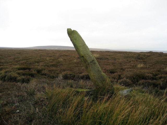
Boundary Stone, Dallowgill Moor Beside the access track to Kettlestang Shooting House, this particular stone has leaned a long way from the intended perpendicular
Boundary Stone, Dallowgill Moor
Beside the access track to Kettlestang Shooting House, this particular stone has leaned a long way from the intended perpendicular
Access Track, Dallowgill Moor Track leading to Kettlestang Shooting House
Access Track, Dallowgill Moor
Track leading to Kettlestang Shooting House
Ordnance Survey cut benchmark Cut benchmark on Long Rod, a 'standing' stone. This mark was used by the Ordnance Survey when calculating height above sea level.
Ordnance Survey cut benchmark
Cut benchmark on Long Rod, a 'standing' stone. This mark was used by the Ordnance Survey when calculating height above sea level.
Long Rod A rather drunken looking standing stone close by the track to Kettlestang Shooting House. Chris Heaton has suggested this might be a boundary stone, but there are no signs of either parish or estate boundaries here. However old 19thC OS maps show another trackway [now lost] coming from Harper Hill <a href="https://www.geograph.org.uk/gridref/SE195703">SE195703</a> via Old Wife standing stone and heading on roughly westwards over the moor towards Nidderdale, so maybe this was a waymarker.
Long Rod
A rather drunken looking standing stone close by the track to Kettlestang Shooting House. Chris Heaton has suggested this might be a boundary stone, but there are no signs of either parish or estate boundaries here. However old 19thC OS maps show another trackway [now lost] coming from Harper Hill SE195703 via Old Wife standing stone and heading on roughly westwards over the moor towards Nidderdale, so maybe this was a waymarker.
Tractor parked on the moor A rather old and battered tractor parked on the moor near to Long Rod standing stone. Kettlestang Shooting House can be seen in the distance close to the small stand of trees.
Tractor parked on the moor
A rather old and battered tractor parked on the moor near to Long Rod standing stone. Kettlestang Shooting House can be seen in the distance close to the small stand of trees.
This way to the Algarve? One of a line of grouse butts on Dallow Moor. Each line appears to have a different name, this particular group being called 'Portugal' for some strange reason. Butts on the moor around here do not always follow lines shown on the OS map. Some must be relatively new creations, whilst others, such as those to the NE of the shooting house have been abandoned and are slowly returning to nature.
This way to the Algarve?
One of a line of grouse butts on Dallow Moor. Each line appears to have a different name, this particular group being called 'Portugal' for some strange reason. Butts on the moor around here do not always follow lines shown on the OS map. Some must be relatively new creations, whilst others, such as those to the NE of the shooting house have been abandoned and are slowly returning to nature.
Shooters' track across the moor The access track for Kettlestang Shooting House, which can be seen near the right hand edge of the photo. This whole area is given over to grouse shooting, so the moor is managed to encourage heather growth. If left to nature it would eventually become scrub and bog with scattered birch trees. Areas of heather are regularly burnt in autumn or early spring to encourage new growth which grouse feed on. This area is a SSSI, noted for moorland plants and wildlife. Note: the map shows a line of grouse butts alongside the track to the left, but these have been destroyed and rebuilt at a right angle to the track.
Shooters' track across the moor
The access track for Kettlestang Shooting House, which can be seen near the right hand edge of the photo. This whole area is given over to grouse shooting, so the moor is managed to encourage heather growth. If left to nature it would eventually become scrub and bog with scattered birch trees. Areas of heather are regularly burnt in autumn or early spring to encourage new growth which grouse feed on. This area is a SSSI, noted for moorland plants and wildlife. Note: the map shows a line of grouse butts alongside the track to the left, but these have been destroyed and rebuilt at a right angle to the track.
Old Wife on the moor This short standing stone is known as 'Old Wife', for what reason I'm unsure. It appears to stand in the middle of nowhere between a modern 4X4 track and a line of grouse butts, but if one looks at OS maps of the 19thC the reason for its existence appears clearer as a footpath or track is shown crossing the moor roughly east to west passing both this stone and that of Long Rod some 700m further west. Both stones may well have been waymarkers on an ancient route, now lost, between Nidderdale and Dallow etc. Grouse butts on this moor appear to have names, the small sign in the background naming this area as 'Jonathan's Line'.
Old Wife on the moor
This short standing stone is known as 'Old Wife', for what reason I'm unsure. It appears to stand in the middle of nowhere between a modern 4X4 track and a line of grouse butts, but if one looks at OS maps of the 19thC the reason for its existence appears clearer as a footpath or track is shown crossing the moor roughly east to west passing both this stone and that of Long Rod some 700m further west. Both stones may well have been waymarkers on an ancient route, now lost, between Nidderdale and Dallow etc. Grouse butts on this moor appear to have names, the small sign in the background naming this area as 'Jonathan's Line'.
A boulder
A boulder
Long Rod
Long Rod
Fenn trap, Dallow Moor
Benchmark cut into stone pillar, Long Rod The benchmark is cut into a tall stone pillar to the west of the track on Dallow Moor. Wider view <a href="https://www.geograph.org.uk/photo/7561802">SE1770 : Long Rod, Dallow Moor</a>
Benchmark cut into stone pillar, Long Rod
The benchmark is cut into a tall stone pillar to the west of the track on Dallow Moor. Wider view SE1770 : Long Rod, Dallow Moor
Long Rod, Dallow Moor There is a benchmark cut into the tall stone pillar to the west of the track on Dallow Moor. Closer view <a href="https://www.geograph.org.uk/photo/7561800">SE1770 : Benchmark cut into stone pillar, Long Rod</a>
Long Rod, Dallow Moor
There is a benchmark cut into the tall stone pillar to the west of the track on Dallow Moor. Closer view SE1770 : Benchmark cut into stone pillar, Long Rod
North Oaks
North Oaks
Moor Top Junction & Cattle Grid
High Bishopside Moor Not much here besides sheep, wind, rough grass and tumbled down walls
High Bishopside Moor
Not much here besides sheep, wind, rough grass and tumbled down walls
Bishop's Moor An "entry point" as part of the new right to roam onto the moor on High Bishopside.
Bishop's Moor
An "entry point" as part of the new right to roam onto the moor on High Bishopside.
Show me another place!

Bishop's Moor is located at Grid Ref: SE1768 (Lat: 54.112316, Lng: -1.7377996)

Division: West Riding

Administrative County: North Yorkshire

District: Harrogate

Police Authority: North Yorkshire

What 3 Words

///seashell.easy.websites. Near Pateley Bridge, North Yorkshire

Nearby Locations

Bishop's Moor

Related Wikis

High and Low Bishopside

High and Low Bishopside is a civil parish in Nidderdale in the Harrogate district, in the county of North Yorkshire, England. It includes the town of Pateley...

Wath-in-Nidderdale

Wath, sometimes known as Wath-in-Nidderdale to distinguish it from other places named Wath, is a village in the Harrogate district of North Yorkshire,...

Wath-in-Nidderdale railway station

Wath-in-Nidderdale railway station, was one of two intermediate stations on the Nidd Valley Light Railway, in Wath-in-Nidderdale, Yorkshire, England. The...

Nidderdale Museum

Nidderdale Museum is a local and social history museum in the market town of Pateley Bridge in Nidderdale, one of the Yorkshire Dales, in North Yorkshire...

Pateley Bridge railway station (Nidd Valley Light Railway)

Pateley Bridge railway station (NVLR) was a railway station serving the southern terminus of the Nidd Valley Light Railway, in Pateley Bridge, North Yorkshire...

Nidderdale AONB

The Nidderdale AONB is an Area of Outstanding Natural Beauty in North Yorkshire, England, bordering the Yorkshire Dales National Park to the east and south...

Nidderdale

Nidderdale, historically also known as Netherdale, is one of the Yorkshire Dales (although outside the Yorkshire Dales National Park) in North Yorkshire...

Pateley Playhouse

The Pateley Playhouse is a small amateur-run theatre in the town of Pateley Bridge in Nidderdale, North Yorkshire, England. The building was initially...

Have you been to Bishop's Moor?

Leave your review of Bishop's Moor below (or comments, questions and feedback).