Cow Park

Downs, Moorland in Yorkshire Richmondshire

England

Cow Park

Cattle Grid, Coldstorms Farm Track leading from A6108 Walburnhead to the farm.
Cattle Grid, Coldstorms Farm Credit: wfmillar

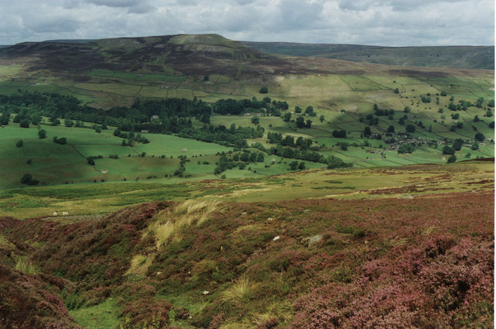
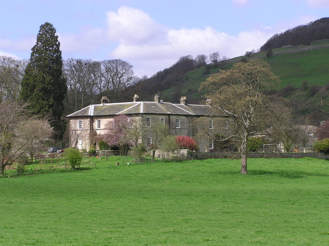
Cow Park is a picturesque natural reserve located in the region of Yorkshire, England. Nestled amidst the stunning landscape of the Yorkshire Downs and Moorland, Cow Park is renowned for its breathtaking beauty and diverse flora and fauna.

Covering an expansive area of approximately 500 acres, Cow Park offers a tranquil retreat for nature enthusiasts and hikers alike. The park's rolling hills and lush green meadows provide a perfect habitat for a variety of wildlife species, including cows, sheep, and numerous bird species.

Visitors to Cow Park can enjoy a multitude of outdoor activities, such as hiking, picnicking, and photography. The park boasts an extensive network of well-maintained trails, offering breathtaking views of the surrounding countryside. Whether it's a leisurely stroll or a challenging hike, there is a trail suitable for every level of fitness.

Wildflower enthusiasts will be delighted by the vibrant display of colors that adorn the park during spring and summer. The meadows burst with a plethora of wildflowers, including buttercups, daisies, and bluebells, creating a captivating sight.

In addition to its natural beauty, Cow Park also provides a glimpse into the region's agricultural heritage. Traditional farming methods are still practiced here, and visitors can witness cows and sheep grazing peacefully in the open fields.

With its idyllic setting and abundant wildlife, Cow Park offers a serene escape from the hustle and bustle of everyday life. Whether one seeks solace in nature or desires an active outdoor adventure, a visit to Cow Park is sure to leave a lasting impression.

If you have any feedback on the listing, please let us know in the comments section below.

Cow Park Images

Images are sourced within 2km of 54.355386/-1.8400384 or Grid Reference SE1095. Thanks to Geograph Open Source API. All images are credited.
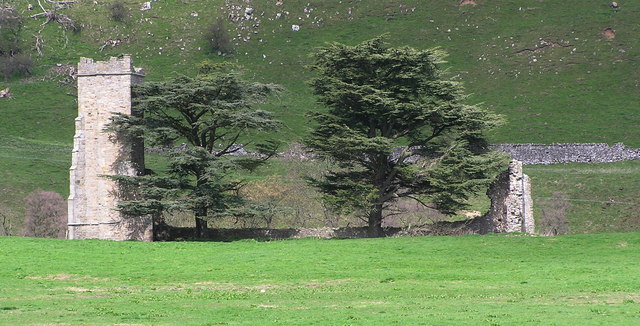
Cattle Grid, Coldstorms Farm Track leading from A6108 Walburnhead to the farm.
Cattle Grid, Coldstorms Farm
Track leading from A6108 Walburnhead to the farm.
Walburnhead, A6108 Near track to Coldstorms Farm.
Walburnhead, A6108
Near track to Coldstorms Farm.
Boston Bridge Carries the A6108 over Black Beck. View from Boston Farm track. Notice the crows gathering.
Boston Bridge
Carries the A6108 over Black Beck. View from Boston Farm track. Notice the crows gathering.
Boston Beck A6108 crossing the beck near Boston Farm.
Boston Beck
A6108 crossing the beck near Boston Farm.
Walburn Hall Viewed from the junction of A6108 and minor road to Wathgill Camp.
Walburn Hall
Viewed from the junction of A6108 and minor road to Wathgill Camp.
Fields near Downholme View across sheep grazing land with Gill Beck on the immediate left leading to Swaledale.
Fields near Downholme
View across sheep grazing land with Gill Beck on the immediate left leading to Swaledale.
Fields towards Crow Woods Approaching Walburnhead
Fields towards Crow Woods
Approaching Walburnhead
A6108 passing Walburn Hall
Road junction at Walburn Hall
Approaching Bellerby road junction From A6108 towards Leyburn
Approaching Bellerby road junction
From A6108 towards Leyburn
Walburn Hall Grade I Listed fortified manor house previously larger than the present working farmhouse and possibly on the site of a 12th century house. Originally 15th and 16th century built by the Scrope family it was restored by Timothy Hutton of Marske in Swaledale early in the 19th century and virtually all that remains of a deserted medieval village. Reputed to have accommodated Mary Queen of Scots. The hall and moorland was in the hands of the Hutton family from 1755 to the 20th century.
Walburn Hall
Grade I Listed fortified manor house previously larger than the present working farmhouse and possibly on the site of a 12th century house. Originally 15th and 16th century built by the Scrope family it was restored by Timothy Hutton of Marske in Swaledale early in the 19th century and virtually all that remains of a deserted medieval village. Reputed to have accommodated Mary Queen of Scots. The hall and moorland was in the hands of the Hutton family from 1755 to the 20th century.
Traces of snow above Gill Beck There was still snow in banks from road-ploughing and in the shelter of drystone walls, though it felt pretty hot to me cycling up from Richmond before the bitter wind set in later in the day.
Traces of snow above Gill Beck
There was still snow in banks from road-ploughing and in the shelter of drystone walls, though it felt pretty hot to me cycling up from Richmond before the bitter wind set in later in the day.
The Gate to Range 6A The gate on the track to range 6A near Wathgill Camp, taken from the parking area next to the range console.
The Gate to Range 6A
The gate on the track to range 6A near Wathgill Camp, taken from the parking area next to the range console.
Track over Walburn Moor The range track across the top of Walburn Moor, with part of Wathgill Camp in the foreground.
Track over Walburn Moor
The range track across the top of Walburn Moor, with part of Wathgill Camp in the foreground.
Downholme Ford This ford on the Gill Beck is found on Stop Bridge Lane.
<span class="nowrap"><a title="https://youtu.be/f3Grs1m-Gk8" rel="nofollow ugc noopener" href="https://youtu.be/f3Grs1m-Gk8">Link</a><img style="margin-left:2px;" alt="External link" title="External link - shift click to open in new window" src="https://s1.geograph.org.uk/img/external.png" width="10" height="10"/></span>
Downholme Ford
This ford on the Gill Beck is found on Stop Bridge Lane. LinkExternal link
Morelands Well 6E (Morelands Well) AFV Machine Gun Range, according to the sign. Mary Morelands Well according to the OS map.
Morelands Well
6E (Morelands Well) AFV Machine Gun Range, according to the sign. Mary Morelands Well according to the OS map.
Site of Walburn DMV There was a village here in the medieval period, but all that remains now is nearby Walburn Hall and its associated buildings. The village extended up this hillside and along either side of the short straight of the A6108 past the hall, the visible ridges here being the outlines of the 'crofts and tofts' which were the houses and their long 'gardens' used for cultivation and the keeping of a few animals. Little can be seen in this photo, but the houses were to the right of the photo facing what is now a stone wall down the middle of what was once a green with a small stream running down the centre. The crofts extended across the hillside to the left with a 'back lane' now visible as a sunken way [off picture to left]. To the right of the wall and below the small copse were more houses which faced the green from the other side.  This is one of the best deserted medieval village sites in North Yorkshire and is well documented, but unfortunately is all on private land. For details of this and other sites in the area, read 'Valley of the Wild River' by Andrew Fleming.
Site of Walburn DMV
There was a village here in the medieval period, but all that remains now is nearby Walburn Hall and its associated buildings. The village extended up this hillside and along either side of the short straight of the A6108 past the hall, the visible ridges here being the outlines of the 'crofts and tofts' which were the houses and their long 'gardens' used for cultivation and the keeping of a few animals. Little can be seen in this photo, but the houses were to the right of the photo facing what is now a stone wall down the middle of what was once a green with a small stream running down the centre. The crofts extended across the hillside to the left with a 'back lane' now visible as a sunken way [off picture to left]. To the right of the wall and below the small copse were more houses which faced the green from the other side. This is one of the best deserted medieval village sites in North Yorkshire and is well documented, but unfortunately is all on private land. For details of this and other sites in the area, read 'Valley of the Wild River' by Andrew Fleming.
Show me another place!

Cow Park is located at Grid Ref: SE1095 (Lat: 54.355386, Lng: -1.8400384)

Division: North Riding

Administrative County: North Yorkshire

District: Richmondshire

Police Authority: North Yorkshire

What 3 Words

///unsecured.ships.spends. Near Leyburn, North Yorkshire

Nearby Locations

Cow Park

Related Wikis

Swaledale

Swaledale is a valley in North Yorkshire, England. It is one of the Yorkshire Dales, which are part of the Pennines, and within the Yorkshire Dales National...

Stainton, west North Yorkshire

Stainton is a hamlet and civil parish in the North Yorkshire district of North Yorkshire, England. It is located just outside the Yorkshire Dales National...

Walburn, North Yorkshire

Walburn is a hamlet and civil parish in North Yorkshire, England. It is located in lower Swaledale, 5 miles (8 km) south-west of Richmond. The population...

Downholme

Downholme is a village and civil parish in North Yorkshire, England. It is situated approximately 4 miles (6 km) west from the market town of Richmond...

Bellerby

Bellerby is a village and civil parish in North Yorkshire, England, about 7 miles (11 km) south-west of Richmond. The village has one pub, the Cross Keys...

Ellerton Priory (Swaledale)

Ellerton Priory was a priory of Cistercian nuns in Swaledale in North Yorkshire, England. Its ruins lie in the civil parish of Ellerton Abbey. == History... ==

Ellerton Abbey House

Ellerton Abbey House is an historic building and estate in Ellerton Abbey, North Yorkshire, England. It was built around 1830 for the Fore Erle-Drax family...

Ellerton Abbey

Ellerton Abbey is a civil parish in the Richmondshire district of North Yorkshire, England. It is located on the River Swale in lower Swaledale, 6 miles...

Nearby Amenities

Located within 500m of 54.355386,-1.8400384
Military: checkpoint
Lat/Long: 54.3567536/-1.8331014
The data included in this document is from www.openstreetmap.org. The data is made available under ODbL.

Have you been to Cow Park?

Leave your review of Cow Park below (or comments, questions and feedback).