Netherhampton Down

Downs, Moorland in Wiltshire

England

Netherhampton Down

Looking up the track at Salisbury racecourse
Looking up the track at Salisbury racecourse Credit: Helen Steed

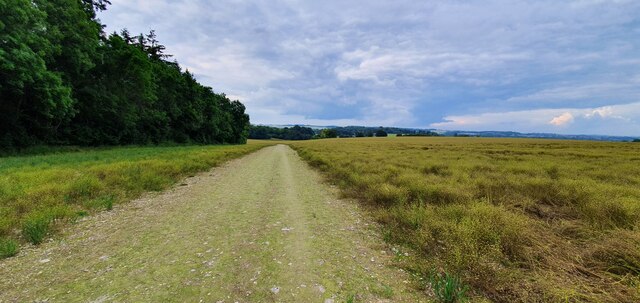
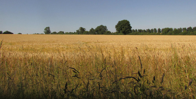
Netherhampton Down is a picturesque area located in the county of Wiltshire, England. It is characterized by its rolling hills, open grasslands, and patches of heathland, making it a prime example of downs and moorland landscapes. The Down is situated near the village of Netherhampton, just a few miles southwest of the historic city of Salisbury.

Covering an area of approximately 800 acres, Netherhampton Down offers breathtaking panoramic views of the surrounding countryside. The landscape is dominated by gently sloping hills, which are covered in lush green grass during the summer months. These hills are interspersed with areas of heather and gorse, providing a burst of color and attracting a variety of wildlife.

Netherhampton Down is a haven for nature lovers and outdoor enthusiasts. The area is home to a rich diversity of flora and fauna, including various species of birds, butterflies, and wildflowers. Visitors can enjoy leisurely walks or hikes through the open grasslands, following the well-maintained footpaths that crisscross the Down.

The Down also has historical significance, with evidence of human activity dating back thousands of years. Archaeological finds, such as ancient burial mounds and remnants of Iron Age settlements, have been discovered in the area, adding to its cultural value.

Overall, Netherhampton Down, Wiltshire, offers a serene and idyllic escape from the hustle and bustle of city life. Its natural beauty, stunning views, and rich history make it a must-visit destination for those seeking tranquility and a connection with nature.

If you have any feedback on the listing, please let us know in the comments section below.

Netherhampton Down Images

Images are sourced within 2km of 51.055699/-1.8548737 or Grid Reference SU1028. Thanks to Geograph Open Source API. All images are credited.

Looking up the track at Salisbury racecourse
Footpath across Warren Down
Farmland near Stratford Tony
Track to Hare Warren Lodge
Track junction in Hare Warren
Old Shaftsbury Drove through Hare Warren
Stands at Salisbury Racecourse
Combe, Stratford Tony From Portfield Road. <a href="https://www.geograph.org.uk/photo/315918">SU0827 : Valley taken from Portfield Road</a> shows the same combe from further south along the road, looking in a different direction. The combe leads down to the valley of the River Ebble.
Combe, Stratford Tony
From Portfield Road. SU0827 : Valley taken from Portfield Road shows the same combe from further south along the road, looking in a different direction. The combe leads down to the valley of the River Ebble.
Barley near Stratford Tony On the other side of Stratford Tony Road from <a href="https://www.geograph.org.uk/photo/5905872">SU0926 : By Stratford Tony Road</a>. The far hedge is followed by a parish boundary.
Barley near Stratford Tony
On the other side of Stratford Tony Road from SU0926 : By Stratford Tony Road. The far hedge is followed by a parish boundary.
Stratford Tony Road The road along the Ebble valley takes a curve on its way to Combe Bissett.
Stratford Tony Road
The road along the Ebble valley takes a curve on its way to Combe Bissett.
Road to Salisbury Racecourse Climbing from Stratford Tony. The distant woodland is at Hare Warren.
Road to Salisbury Racecourse
Climbing from Stratford Tony. The distant woodland is at Hare Warren.
Barley near Stratford Tony Looking back to the left from where <a href="https://www.geograph.org.uk/photo/5909685">SU0927 : Road to Salisbury Racecourse</a> was taken, towards the distant Ebble valley.
Barley near Stratford Tony
Looking back to the left from where SU0927 : Road to Salisbury Racecourse was taken, towards the distant Ebble valley.
Farmland near Stratford Tony The nearer wood is on North Down.
Farmland near Stratford Tony
The nearer wood is on North Down.
Barley near Stratford Tony The farm buildings are at Coombe Farm. Beyond is the Ebble valley.
Barley near Stratford Tony
The farm buildings are at Coombe Farm. Beyond is the Ebble valley.
Farmland near Stratford Tony <a href="https://www.geograph.org.uk/photo/5909728">SU0927 : Barley near Stratford Tony</a> is a detail of this view taken looking right from the same place as <a href="https://www.geograph.org.uk/photo/5909719">SU0927 : Farmland near Stratford Tony</a>.
Farmland near Stratford Tony
SU0927 : Barley near Stratford Tony is a detail of this view taken looking right from the same place as SU0927 : Farmland near Stratford Tony.
Road to Stratford Tony Looking right from where <a href="https://www.geograph.org.uk/photo/5909719">SU0927 : Farmland near Stratford Tony</a> was taken, with the road heading towards the Ebble valley.
Road to Stratford Tony
Looking right from where SU0927 : Farmland near Stratford Tony was taken, with the road heading towards the Ebble valley.
Old Shaftesbury Drove by Hare Warren Byway open to all traffic BSTO 39 runs along the southern edge of Hare Warren.
Old Shaftesbury Drove by Hare Warren
Byway open to all traffic BSTO 39 runs along the southern edge of Hare Warren.
Old Shaftesbury Drove by Hare Warren Further west along byway open to all traffic BSTO 39 from <a href="https://www.geograph.org.uk/photo/5909751">SU0828 : Old Shaftesbury Drove by Hare Warren</a>.
Old Shaftesbury Drove by Hare Warren
Further west along byway open to all traffic BSTO 39 from SU0828 : Old Shaftesbury Drove by Hare Warren.
Show me another place!

Netherhampton Down is located at Grid Ref: SU1028 (Lat: 51.055699, Lng: -1.8548737)

Unitary Authority: Wiltshire

Police Authority: Wiltshire

What 3 Words

///spoil.ambushes.supported. Near Wilton, Wiltshire

Nearby Locations

Netherhampton Down

Related Wikis

Salisbury Racecourse

Salisbury Racecourse is a flat racecourse in the United Kingdom featuring thoroughbred horse racing, 3 miles (5 km) southwest of Salisbury, Wiltshire,...

Netherhampton

Netherhampton is a village and civil parish in Wiltshire, England, immediately west of the city of Salisbury. The village is about 2 miles (3.2 km) from...

Coombe Bissett

Coombe Bissett is a village and civil parish in the English county of Wiltshire in the River Ebble valley, 3 miles (4.8 km) southwest of Salisbury on the...

Stratford Tony

Stratford Tony, also spelt Stratford Toney, formerly known as Stratford St Anthony and Toney Stratford, is a small village and civil parish in southern...

St Mary & St Lawrence's Church, Stratford Tony

The Church of St Mary & St Lawrence in the village of Stratford Tony, south Wiltshire, England, was built in the 13th century. It stands on the south bank...

Wilton Abbey

Wilton Abbey was a Benedictine convent in Wiltshire, England, three miles west of Salisbury, probably on the site now occupied by Wilton House. It was...

Wilton House

Wilton House is an English country house at Wilton near Salisbury in Wiltshire, which has been the country seat of the Earls of Pembroke for over 400 years...

West Harnham Chalk Pit

West Harnham Chalk Pit (grid reference SU128287) is a 2.8 hectare geological Site of Special Scientific Interest in Wiltshire, England, notified in 1971...

Nearby Amenities

Located within 500m of 51.055699,-1.8548737
Netherhampton Down
Ele: 120
Natural: peak
Lat/Long: 51.0520671/-1.8528962
The data included in this document is from www.openstreetmap.org. The data is made available under ODbL.

Have you been to Netherhampton Down?

Leave your review of Netherhampton Down below (or comments, questions and feedback).