Brown Hill Plain

Downs, Moorland in Yorkshire Harrogate

England

Brown Hill Plain

The valley of Ashfoldside Beck Looking up from Prosperous Smelt Mill.
The valley of Ashfoldside Beck Credit: Malcolm Street

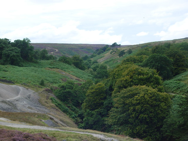
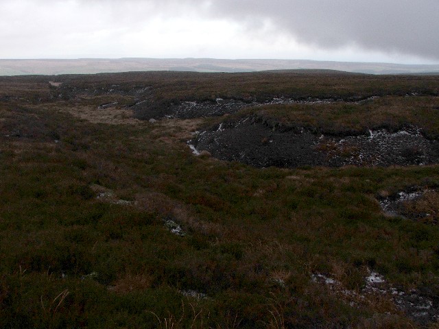
Brown Hill Plain is a vast expanse of moorland located in Yorkshire, England. Situated in the northern part of the county, it forms part of the Yorkshire Dales National Park. This picturesque area is renowned for its stunning landscapes, rugged terrain, and rich biodiversity.

Covering an area of approximately 1,500 hectares, Brown Hill Plain is characterized by its undulating hills, heather-clad slopes, and open grasslands. The moorland is intersected by streams and rivers, which add to its natural beauty. The terrain is largely made up of peat, which has accumulated over thousands of years, creating a unique ecosystem.

The vegetation on Brown Hill Plain is predominantly heather, with patches of grasses and shrubs. This moorland habitat provides a suitable environment for a range of plant and animal species. Common plant species found here include bilberry, cotton grass, and sphagnum moss. The area is also home to a variety of bird species, such as curlews, lapwings, and golden plovers, which nest on the moorland.

The Brown Hill Plain offers visitors the opportunity to explore its stunning landscapes through a network of footpaths and trails. Hikers and nature enthusiasts can enjoy panoramic views of the surrounding countryside, while also observing the diverse wildlife that thrives in this unique habitat.

Overall, Brown Hill Plain is a remarkable moorland in Yorkshire, offering visitors a chance to experience the beauty of nature, immerse themselves in its tranquility, and appreciate the wonders of this unique landscape.

If you have any feedback on the listing, please let us know in the comments section below.

Brown Hill Plain Images

Images are sourced within 2km of 54.100202/-1.855777 or Grid Reference SE0967. Thanks to Geograph Open Source API. All images are credited.

The valley of Ashfoldside Beck Looking up from Prosperous Smelt Mill.
The valley of Ashfoldside Beck
Looking up from Prosperous Smelt Mill.
New Shaft Engine House at Merryfield Hole This housed a steam engine which was used to pump water out of the mine shaft surrounded by a fence to the left of it.
New Shaft Engine House at Merryfield Hole
This housed a steam engine which was used to pump water out of the mine shaft surrounded by a fence to the left of it.
Grouse Butt No. 7 on Flout Hill
Shooting Box
Shooting Box
A small waterfall in Colt House Gill Not much water flowing over the cascades.
A small waterfall in Colt House Gill
Not much water flowing over the cascades.
New Shaft at Lower Stoney Grooves The elegant arched portal in the foreground is the outlet from a water wheel. The keystone is beautifully carved. Apparently such craftsmanship was not uncommon for such mundane edifices. The lead mine expert M C Gill tells me that the outlets at Grimwith had similar "Gothic" arches
New Shaft at Lower Stoney Grooves
The elegant arched portal in the foreground is the outlet from a water wheel. The keystone is beautifully carved. Apparently such craftsmanship was not uncommon for such mundane edifices. The lead mine expert M C Gill tells me that the outlets at Grimwith had similar "Gothic" arches
Turf Walls and Rushy Moorland The remains of Old Merryfield Dams, constructed to retain water for the Merryfield Smelt Mill that was located nearby in the Mid 18thC.
Turf Walls and Rushy Moorland
The remains of Old Merryfield Dams, constructed to retain water for the Merryfield Smelt Mill that was located nearby in the Mid 18thC.
Barn & broken walls at Merryfield Marked as a considerably sized building named as Merryfield Hall here in 1849 all that remains is this small stone barn. This was probably a lead miners property and when the mines closed it was demolished.
Barn & broken walls at Merryfield
Marked as a considerably sized building named as Merryfield Hall here in 1849 all that remains is this small stone barn. This was probably a lead miners property and when the mines closed it was demolished.
Old mine workings in Stony Grooves
Jack Hole Moss Jack Hole Moss in the middle distance and Jack Hole Head on the horizon.
More very boggy moorland, to the northeast of Grimwith reservoir.
Jack Hole Moss
Jack Hole Moss in the middle distance and Jack Hole Head on the horizon. More very boggy moorland, to the northeast of Grimwith reservoir.
Wig Stones Swamp. Looking ENE from atop the Wig Stones.
Wig Stones Swamp.
Looking ENE from atop the Wig Stones.
Atop the Wig Stones. My (late) lunchtime view.
Atop the Wig Stones.
My (late) lunchtime view.
Wig Stones. A breakaway boulder on the S side of the Wig Stones.
Wig Stones.
A breakaway boulder on the S side of the Wig Stones.
Wig Stones. The pale brown grassy area just in front of the stones is a disused shaft, not marked on the 1:25,000.  There is, however, a shaft marked beneath Little Wig Stones a few yards away in SE0766 that doesn't exist.  Hmmmm.
Wig Stones.
The pale brown grassy area just in front of the stones is a disused shaft, not marked on the 1:25,000. There is, however, a shaft marked beneath Little Wig Stones a few yards away in SE0766 that doesn't exist. Hmmmm.
Mark Hill Trig A remote and desolate place atop Gouthwaite Moor
Mark Hill Trig
A remote and desolate place atop Gouthwaite Moor
Gouthwaite Moor in Winter A featureless winter landscape. Moor and Bog extend for miles in all directions.
Gouthwaite Moor in Winter
A featureless winter landscape. Moor and Bog extend for miles in all directions.
Tarn on Caygill Moss One of a cluster of small tarns on Caygill Moss
Tarn on Caygill Moss
One of a cluster of small tarns on Caygill Moss
Henstones Hut A ruin of a small square building
Henstones Hut
A ruin of a small square building
Show me another place!

Brown Hill Plain is located at Grid Ref: SE0967 (Lat: 54.100202, Lng: -1.855777)

Division: West Riding

Administrative County: North Yorkshire

District: Harrogate

Police Authority: North Yorkshire

What 3 Words

///markets.icon.existence. Near Pateley Bridge, North Yorkshire

Nearby Locations

Brown Hill Plain

Related Wikis

Stump Cross Caverns

Stump Cross Caverns is a limestone cave system between Wharfedale and Nidderdale in North Yorkshire, England. == Geography == The caverns at Stump Cross...

Stonebeck Down

Stonebeck Down is a civil parish in Harrogate district, North Yorkshire, England. The main settlements in the parish are the village of Ramsgill and the...

Greenhow

Greenhow is a village in North Yorkshire, England, often referred to as Greenhow Hill. The term how derives from the Old Norse word haugr meaning a hill...

Gouthwaite Reservoir

Gouthwaite Reservoir is in Nidderdale, North Yorkshire, England. It is one of many reservoirs in the area, others include Roundhill Reservoir and Angram...

Nearby Amenities

Located within 500m of 54.100202,-1.855777
Brown Hill Plain
Natural: fell
Source: NPE
Lat/Long: 54.1006315/-1.8539072
Stoney Grooves Lead Mine
Historic: mine
Is In Country: UK
Is In County: North Yorkshire
Is In Historical County: Yorkshire
Mineral: lead
Lat/Long: 54.0972235/-1.8577087
Historic: mine_shaft
Mineral: lead
Source: Bing
Lat/Long: 54.0961723/-1.8525048
Historic: mine_shaft
Mineral: lead
Source: Bing
Lat/Long: 54.0980613/-1.8612247
Historic: mine_shaft
Mineral: lead
Source: Bing
Lat/Long: 54.0977452/-1.8600365
Historic: mine_shaft
Mineral: lead
Source: Bing
Lat/Long: 54.0985505/-1.8622466
Historic: mine_shaft
Mineral: lead
Source: Bing
Lat/Long: 54.0983932/-1.8614956
Historic: mine_shaft
Mineral: lead
Source: Bing
Lat/Long: 54.0972862/-1.8583842
Historic: mine_shaft
Mineral: lead
Source: Bing
Lat/Long: 54.0963485/-1.85685
Historic: mine_shaft
Mineral: lead
Source: Bing
Lat/Long: 54.0967008/-1.8561097
Historic: mine_shaft
Mineral: lead
Source: Bing
Lat/Long: 54.0977515/-1.8596717
Historic: mine_shaft
Mineral: lead
Source: Bing
Lat/Long: 54.09828/-1.8607124
Historic: mine_shaft
Mineral: lead
Source: Bing
Lat/Long: 54.0985068/-1.8619033
Historic: mine_shaft
Mineral: lead
Source: Bing
Lat/Long: 54.098022/-1.8603047
The data included in this document is from www.openstreetmap.org. The data is made available under ODbL.

Have you been to Brown Hill Plain?

Leave your review of Brown Hill Plain below (or comments, questions and feedback).