Allington Down
Downs, Moorland in Wiltshire
England
Allington Down
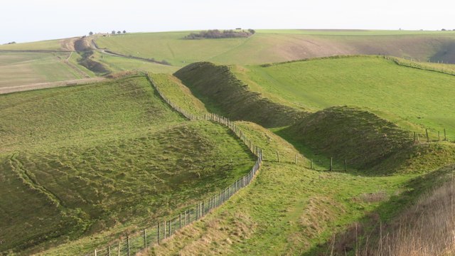
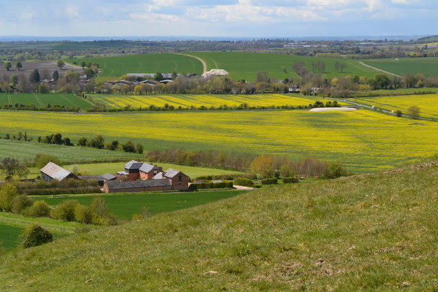
![A walk from Allington to the Wansdyke and back [26] Having descended slightly from the crest of Tan Hill, Wansdyke is reached.
The walk leaves Allington and goes south to run along the towpath of the Kennet and Avon Canal before turning north to cross the minor road at Cannings Cross. Ascending steeply, the path leads to the causewayed enclosure and hillfort of Rybury atop Clifford’s Hill. After a short descent, there is a long climb up Tan Hill to the Wansdyke. A short way along the dyke, the return journey starts, a long descent down a well surfaced track, a public bridleway, to Allington. Just over 4½ miles.](https://s1.geograph.org.uk/geophotos/07/36/51/7365177_965051ec.jpg)
Allington Down is a picturesque area located in the county of Wiltshire, England. It is situated on the western edge of the Salisbury Plain and is known for its stunning downs and moorland landscapes. Covering an area of approximately 12 square miles, Allington Down offers visitors an opportunity to experience the beauty of rural England.
The downs of Allington Down are characterized by their gently rolling hills and lush green meadows. These hills provide breathtaking panoramic views of the surrounding countryside and are a popular spot for walking, hiking, and picnicking. The area is also home to a variety of wildlife, including rabbits, foxes, and a wide range of bird species.
In addition to its downs, Allington Down boasts extensive moorland, featuring heathland and open grass areas. This diverse landscape provides a habitat for many rare plant species, including heather, gorse, and various types of grasses. It is a haven for nature enthusiasts and offers opportunities for birdwatching and wildlife observation.
Allington Down is dotted with several small villages and hamlets, adding to its charm and character. These settlements offer a glimpse into the rural way of life and often feature traditional thatched cottages and historic buildings. The local community is friendly and welcoming, making it a pleasant place to visit or reside.
Overall, Allington Down, Wiltshire is a place of natural beauty and tranquility. It offers visitors a chance to escape the hustle and bustle of city life and immerse themselves in the peacefulness of the countryside. Whether you are seeking outdoor adventures or simply looking to unwind amidst stunning landscapes, Allington Down is sure to captivate and enchant.
If you have any feedback on the listing, please let us know in the comments section below.
Allington Down Images
Images are sourced within 2km of 51.395568/-1.8728907 or Grid Reference SU0866. Thanks to Geograph Open Source API. All images are credited.
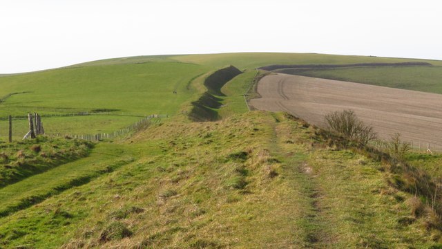
![A walk from Allington to the Wansdyke and back [27] At this junction of tracks, there are three ways to go. This way, after crossing Wansdyke, leads to Allington.
The walk leaves Allington and goes south to run along the towpath of the Kennet and Avon Canal before turning north to cross the minor road at Cannings Cross. Ascending steeply, the path leads to the causewayed enclosure and hillfort of Rybury atop Clifford’s Hill. After a short descent, there is a long climb up Tan Hill to the Wansdyke. A short way along the dyke, the return journey starts, a long descent down a well surfaced track, a public bridleway, to Allington. Just over 4½ miles.](https://s2.geograph.org.uk/geophotos/07/36/51/7365178_fcbdc269.jpg)
![A walk from Allington to the Wansdyke and back [28] At this junction of tracks, there are three ways to go. This way, leads across Allington Down to Beckhampton.
The walk leaves Allington and goes south to run along the towpath of the Kennet and Avon Canal before turning north to cross the minor road at Cannings Cross. Ascending steeply, the path leads to the causewayed enclosure and hillfort of Rybury atop Clifford’s Hill. After a short descent, there is a long climb up Tan Hill to the Wansdyke. A short way along the dyke, the return journey starts, a long descent down a well surfaced track, a public bridleway, to Allington. Just over 4½ miles.](https://s3.geograph.org.uk/geophotos/07/36/51/7365179_099f31f9.jpg)
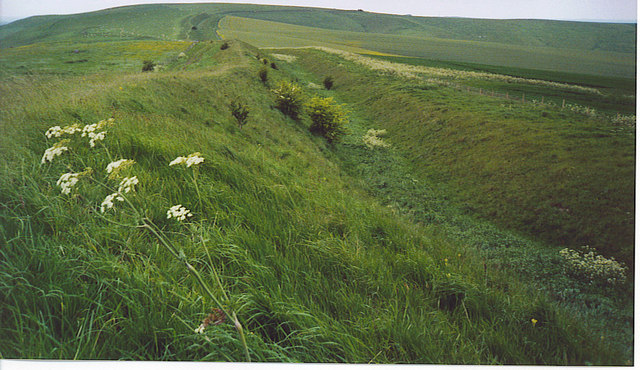
![A walk from Allington to the Wansdyke and back [29] At this junction of tracks, there are three ways to go. This way follows Wansdyke eastwards.
The walk leaves Allington and goes south to run along the towpath of the Kennet and Avon Canal before turning north to cross the minor road at Cannings Cross. Ascending steeply, the path leads to the causewayed enclosure and hillfort of Rybury atop Clifford’s Hill. After a short descent, there is a long climb up Tan Hill to the Wansdyke. A short way along the dyke, the return journey starts, a long descent down a well surfaced track, a public bridleway, to Allington. Just over 4½ miles.](https://s0.geograph.org.uk/geophotos/07/36/51/7365180_91d3f97a.jpg)
![A walk from Allington to the Wansdyke and back [30] Seen from the bridleway, Wansdyke strides across the landscape. In the distance the twin transmission towers atop Morgan's Hill are seen.
The walk leaves Allington and goes south to run along the towpath of the Kennet and Avon Canal before turning north to cross the minor road at Cannings Cross. Ascending steeply, the path leads to the causewayed enclosure and hillfort of Rybury atop Clifford’s Hill. After a short descent, there is a long climb up Tan Hill to the Wansdyke. A short way along the dyke, the return journey starts, a long descent down a well surfaced track, a public bridleway, to Allington. Just over 4½ miles.](https://s1.geograph.org.uk/geophotos/07/36/51/7365181_b4f0bf7b.jpg)
![A walk from Allington to the Wansdyke and back [31] Seen from the bridleway, Wansdyke strides across the landscape. In the distance the twin transmission towers atop Morgan's Hill are seen.
The walk leaves Allington and goes south to run along the towpath of the Kennet and Avon Canal before turning north to cross the minor road at Cannings Cross. Ascending steeply, the path leads to the causewayed enclosure and hillfort of Rybury atop Clifford’s Hill. After a short descent, there is a long climb up Tan Hill to the Wansdyke. A short way along the dyke, the return journey starts, a long descent down a well surfaced track, a public bridleway, to Allington. Just over 4½ miles.](https://s2.geograph.org.uk/geophotos/07/36/51/7365182_a3060f01.jpg)
![A walk from Allington to the Wansdyke and back [32] The well surfaced track, a public bridleway, rises slightly before descending to Allington.
The walk leaves Allington and goes south to run along the towpath of the Kennet and Avon Canal before turning north to cross the minor road at Cannings Cross. Ascending steeply, the path leads to the causewayed enclosure and hillfort of Rybury atop Clifford’s Hill. After a short descent, there is a long climb up Tan Hill to the Wansdyke. A short way along the dyke, the return journey starts, a long descent down a well surfaced track, a public bridleway, to Allington. Just over 4½ miles.](https://s3.geograph.org.uk/geophotos/07/36/51/7365183_03be8ec5.jpg)
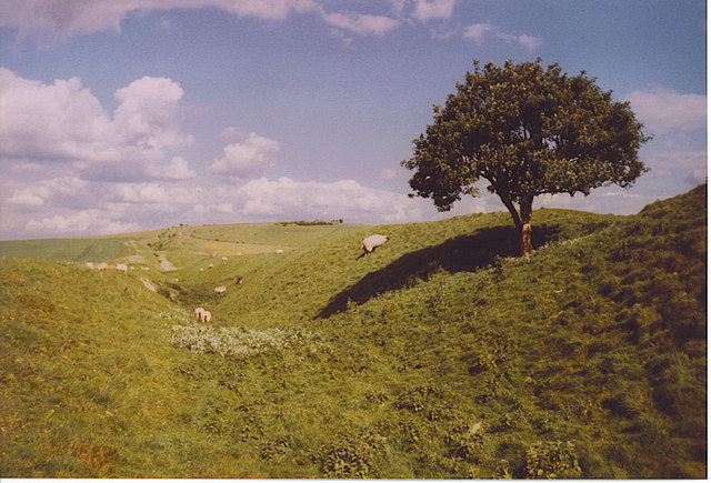
![A walk from Allington to the Wansdyke and back [33] A view across rolling downland, with Roundway Down in the far distance. The cattle do not appear to be appreciating the view.
The walk leaves Allington and goes south to run along the towpath of the Kennet and Avon Canal before turning north to cross the minor road at Cannings Cross. Ascending steeply, the path leads to the causewayed enclosure and hillfort of Rybury atop Clifford’s Hill. After a short descent, there is a long climb up Tan Hill to the Wansdyke. A short way along the dyke, the return journey starts, a long descent down a well surfaced track, a public bridleway, to Allington. Just over 4½ miles.](https://s0.geograph.org.uk/geophotos/07/36/51/7365184_554761e4.jpg)


Allington Down is located at Grid Ref: SU0866 (Lat: 51.395568, Lng: -1.8728907)
Unitary Authority: Wiltshire
Police Authority: Wiltshire
What 3 Words
///cursing.jaundice.hats. Near Avebury, Wiltshire
Nearby Locations
Related Wikis


Nearby Amenities
Located within 500m of 51.395568,-1.8728907Have you been to Allington Down?
Leave your review of Allington Down below (or comments, questions and feedback).