Amersidelaw Moor

Downs, Moorland in Northumberland

England

Amersidelaw Moor

Hepburn Moor, Northumberland A view across Hepburn Moor, with Ros Castle in the distance.
Hepburn Moor, Northumberland Credit: Rebecca A Wills

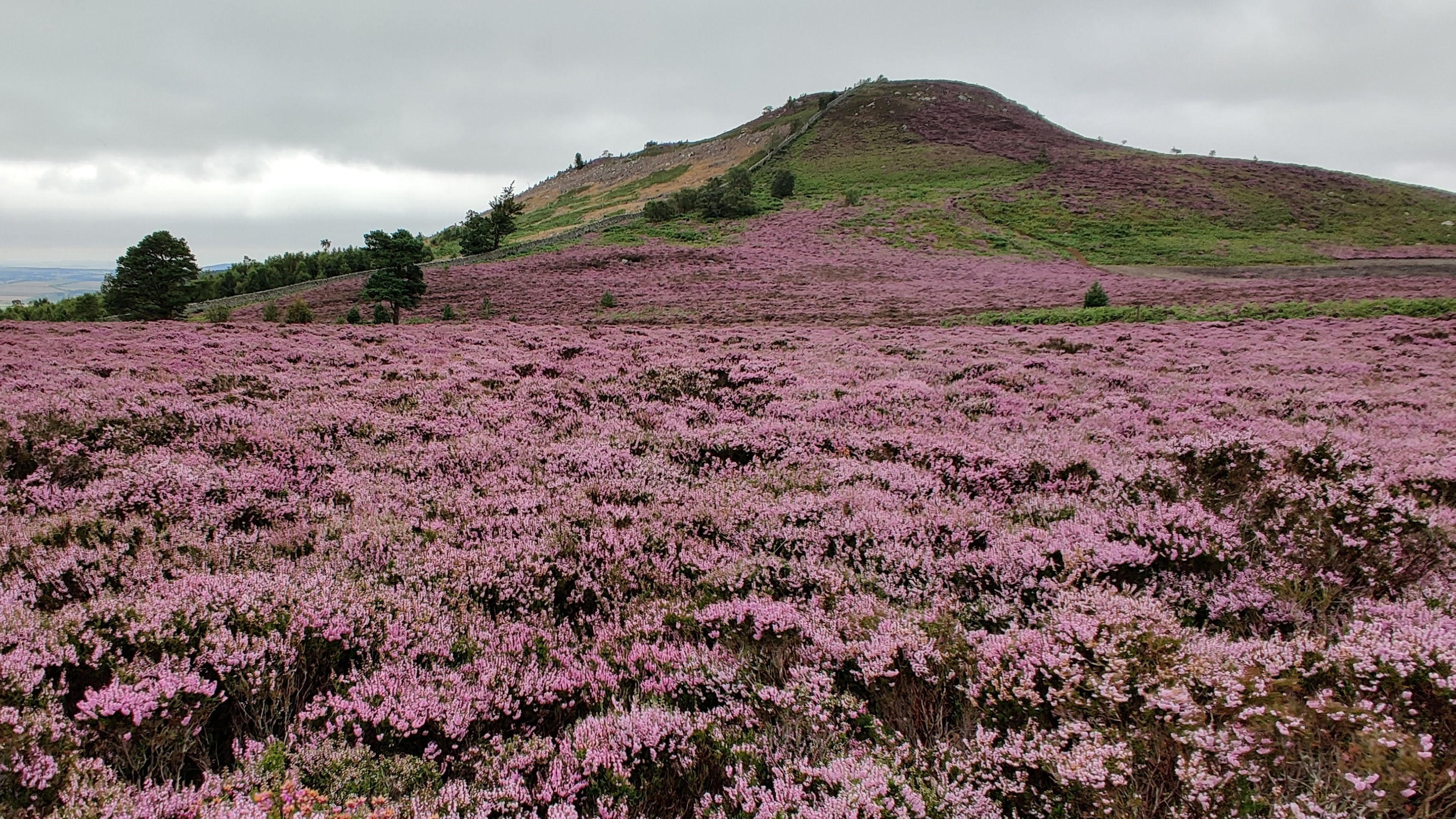
Amersidelaw Moor, located in Northumberland, is a vast expanse of downs and moorland that stretches across the county. This picturesque landscape is characterized by rolling hills, heather-covered moors, and a diverse range of wildlife, making it a popular destination for nature enthusiasts and hikers.

The moorland of Amersidelaw Moor is predominantly made up of open grassland, interspersed with patches of heather and gorse. This creates a striking contrast in colors, from the vibrant purple hues of the heather to the golden tones of the grass. The area is known for its stunning vistas, with panoramic views of the surrounding countryside and distant hills.

The wildlife on Amersidelaw Moor is abundant and varied. Visitors may spot a range of bird species, including curlews, lapwings, and skylarks, as well as birds of prey such as kestrels and merlins. The moorland also provides a habitat for several mammal species, including red squirrels, hares, and roe deer.

For those interested in history, Amersidelaw Moor boasts several archaeological sites, including Bronze Age burial mounds and Iron Age hill forts. These remnants of the past offer insight into the area's rich heritage and add an air of mystery to the landscape.

Accessible through a network of footpaths and trails, Amersidelaw Moor provides ample opportunities for outdoor activities such as walking, cycling, and horse riding. The moorland's remote location and tranquil atmosphere make it an ideal escape from the hustle and bustle of everyday life, allowing visitors to immerse themselves in the natural beauty of Northumberland.

If you have any feedback on the listing, please let us know in the comments section below.

Amersidelaw Moor Images

Images are sourced within 2km of 55.537277/-1.8729146 or Grid Reference NU0827. Thanks to Geograph Open Source API. All images are credited.

Hepburn Moor, Northumberland A view across Hepburn Moor, with Ros Castle in the distance.
Hepburn Moor, Northumberland
A view across Hepburn Moor, with Ros Castle in the distance.
Hepburn Moor, Northumberland Looking towards Chillingham from the vicinity of Ros Castle.
Hepburn Moor, Northumberland
Looking towards Chillingham from the vicinity of Ros Castle.
Roughting Linn Waterfall Mid-summer and only a very light trickle of water over the falls. It's a lovely spot though, straight out of a fantasy film. Note that access is not open to the public and permission should be sought from the land owner.
Roughting Linn Waterfall
Mid-summer and only a very light trickle of water over the falls. It's a lovely spot though, straight out of a fantasy film. Note that access is not open to the public and permission should be sought from the land owner.
Ros Castle Commanding hill overlooking the valley of the River Till, in the ownership of the National Trust.
Ros Castle
Commanding hill overlooking the valley of the River Till, in the ownership of the National Trust.
Trig pillar on Ros Castle The plaque reads:
Ros Castle Camp
This height with its wide prospect was a favourite resort of 
Sir Edward Grey afterwards Viscount Grey of Fallodon KG
Foreign Secretary December 1905 to December 1916.
In 1956 it was presented to the National Trust as part of a National Memorial to him.

The wall behind is part of the extensive wall surrounding the Chillingham estate.
Trig pillar on Ros Castle
The plaque reads: Ros Castle Camp This height with its wide prospect was a favourite resort of Sir Edward Grey afterwards Viscount Grey of Fallodon KG Foreign Secretary December 1905 to December 1916. In 1956 it was presented to the National Trust as part of a National Memorial to him. The wall behind is part of the extensive wall surrounding the Chillingham estate.
Walk-in toposcope on Ros Castle Ros Castle hilltop is the site of an Iron Age hillfort. The toposcope was erected by the YHA. A trig pillar with commemorative plaque <a href="https://www.geograph.org.uk/photo/7156968">NU0825 : Trig pillar on Ros Castle</a> to the left.  The wall is part of the boundary wall of the Chillingham Castle estate.
Walk-in toposcope on Ros Castle
Ros Castle hilltop is the site of an Iron Age hillfort. The toposcope was erected by the YHA. A trig pillar with commemorative plaque NU0825 : Trig pillar on Ros Castle to the left. The wall is part of the boundary wall of the Chillingham Castle estate.
View  eastwards from Ros Castle An extensive view of moorland and forest. In the middle distance, the 20.5 MW capacity Wandylaw Wind Farm <a href="https://www.geograph.org.uk/gridref/NU1224">NU1224</a>, commissioned in 2013 with ten turbines.
View eastwards from Ros Castle
An extensive view of moorland and forest. In the middle distance, the 20.5 MW capacity Wandylaw Wind Farm NU1224, commissioned in 2013 with ten turbines.
The steep path down from Ros Castle A solitary pine tree stands beside the path.
The steep path down from Ros Castle
A solitary pine tree stands beside the path.
Boundary wall of  the Chillingham Castle estate Looking north-east from the summit of Ros Castle
Boundary wall of the Chillingham Castle estate
Looking north-east from the summit of Ros Castle
Boundary wall of the Chillingham Castle estate Looking south-west from the summit of Ros Castle. Trig pillar in the foreground.
Boundary wall of the Chillingham Castle estate
Looking south-west from the summit of Ros Castle. Trig pillar in the foreground.
Wall North East of Ros Castle
Burial mound, Whitehill Head One of many on Sandyford Moor. This is easily visible as Whitehill Head is not covered in heather.
Burial mound, Whitehill Head
One of many on Sandyford Moor. This is easily visible as Whitehill Head is not covered in heather.
Shepherd's Cairn The cairn is almost lost in the blooming heather!
Wandylaw, with 10 turbines on the left, and Middlemoor, with 18 turbines on the right, wind farms are less easily missed.
Shepherd's Cairn
The cairn is almost lost in the blooming heather! Wandylaw, with 10 turbines on the left, and Middlemoor, with 18 turbines on the right, wind farms are less easily missed.
Looking from Shepherd's Cairn south west Towards Ros Castle with its settlement.
Looking from Shepherd's Cairn south west
Towards Ros Castle with its settlement.
In Ros Hill Wood On Millstone Hill.
Walking on the open rides is easy but against the grain almost impossible.
In Ros Hill Wood
On Millstone Hill. Walking on the open rides is easy but against the grain almost impossible.
Looking down along the boundary wall towards Drakestruther Moss The wood to the right has been clear felled leaving large heaps of brash.
Looking down along the boundary wall towards Drakestruther Moss
The wood to the right has been clear felled leaving large heaps of brash.
Looking up Millstone Hill towards Ross Castle With Ros Hill Wood on the left, a fine dry stone wall in the centre and clear felling on the Amersidelaw Moor side.
Looking up Millstone Hill towards Ross Castle
With Ros Hill Wood on the left, a fine dry stone wall in the centre and clear felling on the Amersidelaw Moor side.
Boundary Stone at corner of dry stone wall The stone is marked N (Duke of Northumberland) 1859 on this side and T (Tankerville Estate) on the other side.
A number of substantial dry stone walls were built in 1859.
Boundary Stone at corner of dry stone wall
The stone is marked N (Duke of Northumberland) 1859 on this side and T (Tankerville Estate) on the other side. A number of substantial dry stone walls were built in 1859.
Show me another place!

Amersidelaw Moor is located at Grid Ref: NU0827 (Lat: 55.537277, Lng: -1.8729146)

Unitary Authority: Northumberland

Police Authority: Northumbria

What 3 Words

///jogged.pavement.expel. Near Belford, Northumberland

Nearby Locations

Amersidelaw Moor

Related Wikis

Chillingham cattle

Chillingham cattle, also known as Chillingham wild cattle, is a breed of cattle that live in a large enclosed park at Chillingham Castle, Northumberland...

Ros Hill

Ros Hill, also known as Ros Castle due to the 3,000-year-old Iron Age hill fort on its summit, is a hill in the county of Northumberland in northern England...

Chillingham, Northumberland

Chillingham is a village in Northumberland, England. It is situated approximately 6 km (3.7 mi) to the east of Wooler, south of Chatton. At the 2011 Census...
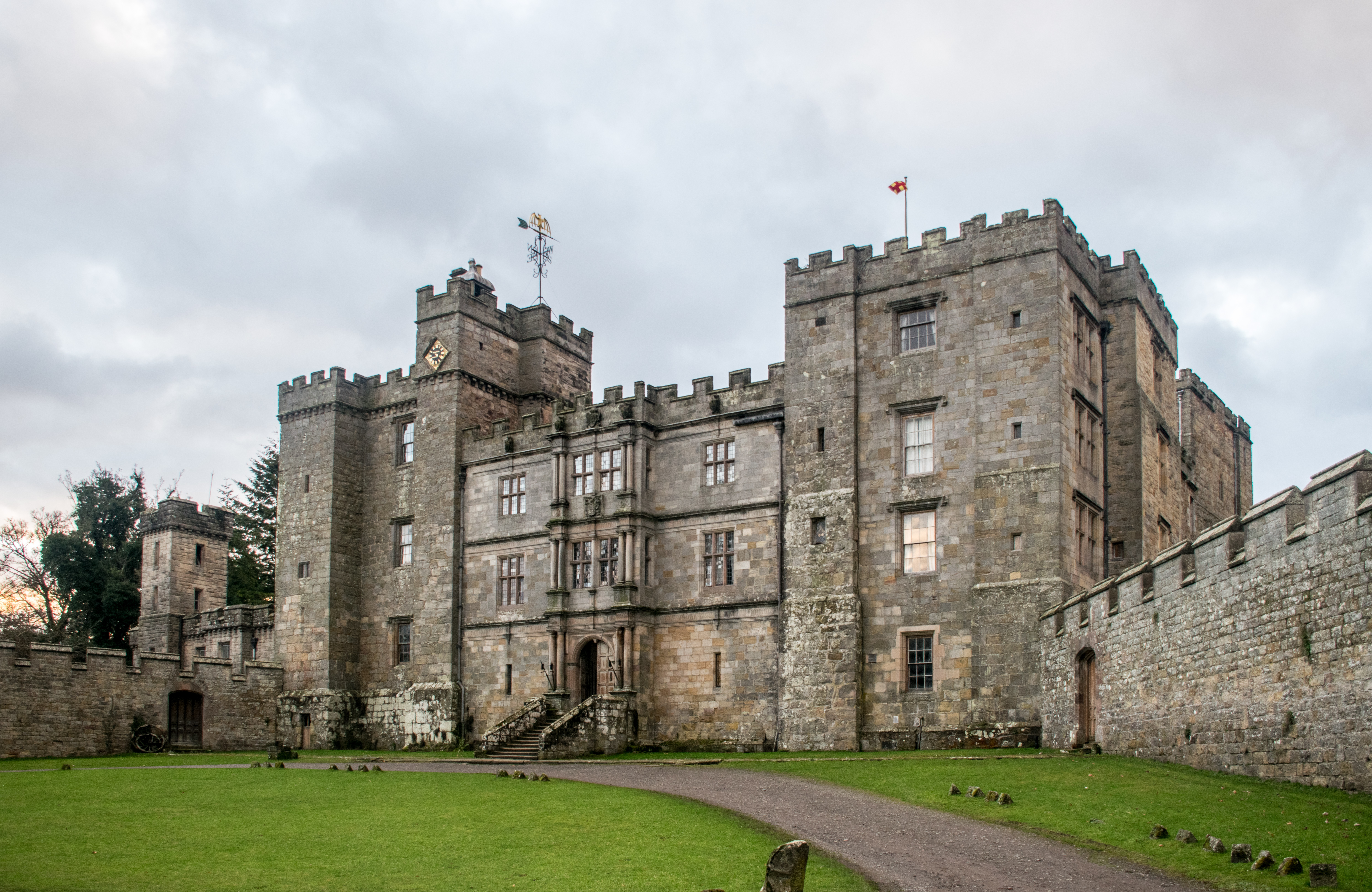
Chillingham Castle

Chillingham Castle is a medieval castle in the village of Chillingham in the northern part of Northumberland, England. It was the seat of the Grey and...

Chatton transmitting station

The Chatton transmitting station is a broadcasting and telecommunications facility, between Wooler and Seahouses, Northumberland. It is owned and operated...

Chatton

Chatton is a village in Northumberland, in England. It is roughly 6 km (3.7 mi) to the east of Wooler. == History == Chatton has been occupied for many...

Hepburn, Northumberland

Hepburn is a hamlet and former civil parish, now in the civil parish of Chillingham in the county of Northumberland, England. The civil parish was merged...

Berwick-upon-Tweed (UK Parliament constituency)

Berwick-upon-Tweed ( ) is a parliamentary constituency in Northumberland represented in the House of Commons of the UK Parliament since 2015 by Anne-Marie...

Nearby Amenities

Located within 500m of 55.537277,-1.8729146
Amersidlaw Moor
Place: locality
Lat/Long: 55.5383619/-1.8726488
Drakestruther
Place: locality
Lat/Long: 55.5357924/-1.8675432
Drakestruther Moss
Place: locality
Lat/Long: 55.5346247/-1.8716841
The data included in this document is from www.openstreetmap.org. The data is made available under ODbL.

Have you been to Amersidelaw Moor?

Leave your review of Amersidelaw Moor below (or comments, questions and feedback).