Dike House Green
Downs, Moorland in Yorkshire Richmondshire
England
Dike House Green
Dike House Green is a picturesque area located in Yorkshire, England. Nestled amidst the stunning Yorkshire Downs and Moorland, this green expanse offers a serene and idyllic setting for nature lovers and outdoor enthusiasts. Spanning across acres of lush green meadows, Dike House Green presents a captivating landscape dotted with vibrant wildflowers, ancient trees, and meandering streams.
The area is renowned for its rich biodiversity and serves as a haven for various species of wildlife. Visitors are often treated to sightings of native birds, such as owls, kestrels, and skylarks, soaring through the clear blue skies. The tranquil ambiance of Dike House Green is further enhanced by the gentle sound of babbling brooks and the occasional rustle of leaves as woodland creatures scurry about.
The Yorkshire Downs, with their rolling hills and sweeping vistas, provide a breathtaking backdrop to Dike House Green. Hikers and walkers can explore the numerous trails that crisscross the region, offering panoramic views of the surrounding countryside. Moorland, with its rugged beauty, adds another dimension to the landscape, showcasing vast expanses of heather-covered hills and rugged rock formations.
Dike House Green is a haven for those seeking outdoor activities, including picnicking, bird-watching, photography, and even horse riding. The area is also home to several historic landmarks, such as Dike House, a grand country house dating back to the 17th century.
Overall, Dike House Green offers a peaceful retreat from the hustle and bustle of city life, providing visitors with an opportunity to immerse themselves in the beauty and tranquility of the Yorkshire countryside.
If you have any feedback on the listing, please let us know in the comments section below.
Dike House Green Images
Images are sourced within 2km of 54.378918/-1.9459594 or Grid Reference SE0398. Thanks to Geograph Open Source API. All images are credited.
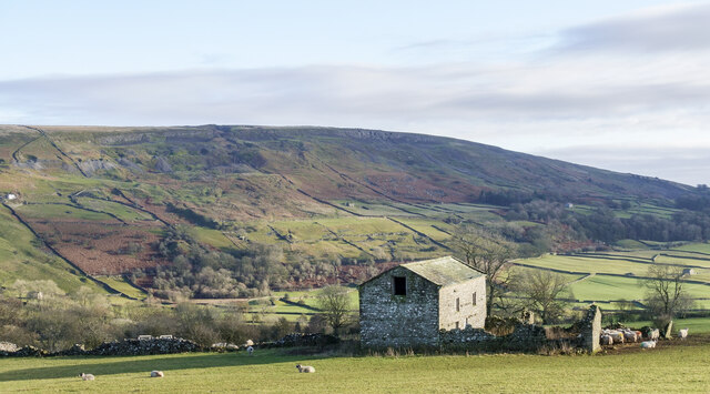
![A circular walk from Reeth via Fremington Edge [15] A prominent field barn alongside the path.
From Reeth the route climbs very steeply to run along rocky Fremington Edge on Marrick Moor. A gentler descent in the direction of Marrick village follows before turning right towards Grinton. Then along the banks of the River Swale and Arkle Beck to return to Reeth. About 4¾ miles.](https://s0.geograph.org.uk/geophotos/07/28/13/7281300_758b388a.jpg)
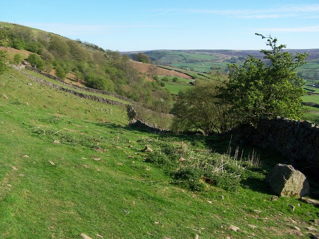
![A circular walk from Reeth via Fremington Edge [16] A look back along the path, past the bridleway and past the field barn seen at <a href="https://www.geograph.org.uk/photo/7281300">NZ0400 : A circular walk from Reeth via Fremington Edge [15]</a>. Beyond is the village of Reeth and in the distance Harkerside Moor.
From Reeth the route climbs very steeply to run along rocky Fremington Edge on Marrick Moor. A gentler descent in the direction of Marrick village follows before turning right towards Grinton. Then along the banks of the River Swale and Arkle Beck to return to Reeth. About 4¾ miles.](https://s1.geograph.org.uk/geophotos/07/28/13/7281301_f394aa73.jpg)


Dike House Green is located at Grid Ref: SE0398 (Lat: 54.378918, Lng: -1.9459594)
Division: North Riding
Administrative County: North Yorkshire
District: Richmondshire
Police Authority: North Yorkshire
What 3 Words
///gain.minivans.leotard. Near Leyburn, North Yorkshire
Nearby Locations
Related Wikis

Arkle Beck
Arkle Beck is the stream running through the valley of Arkengarthdale in the Yorkshire Dales, England. It is a tributary of the River Swale, which it joins...

Reeth
Reeth is a village 11 miles (18 km) west of Richmond in North Yorkshire, England, in the civil parish of Reeth, Fremington and Healaugh. Historically part...

Swaledale Festival
The Swaledale Festival takes place over two weeks in May and June each year, in churches, chapels, castles, ‘Literary Institutes’, pubs, fields and village...
Grinton
Grinton is a small village and civil parish in the Yorkshire Dales, North Yorkshire, England. Close to Reeth and Fremington, it lies 9 miles (15 km) west...
Nearby Amenities
Located within 500m of 54.378918,-1.9459594Have you been to Dike House Green?
Leave your review of Dike House Green below (or comments, questions and feedback).