Barnard Castle Allotment

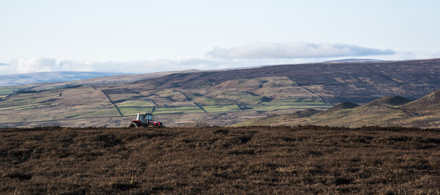
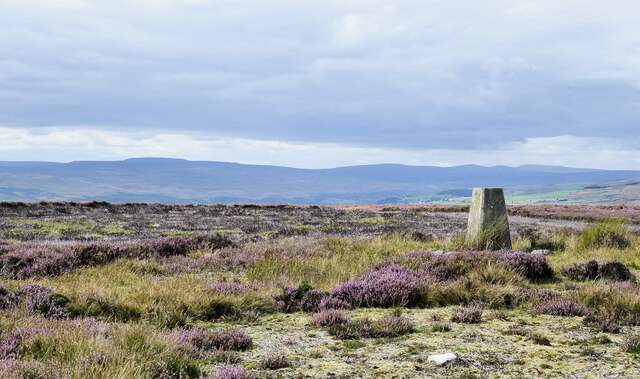
Downs, Moorland in Durham

England

Barnard Castle Allotment

Bales near, far and beyond Three sets of bales can be seen in the image, (one is quite distant), and there are more such piles on Langleydale Common. They were first thought to be conventional bales of straw or grass but they're not; it's bracken! There are mown areas of bracken on the moor and it seems clear that the 'mowings' have been collected and baled. The purpose of the exercise is uncertain but it is known that bracken is not a favoured species for ground cover so perhaps the plan is to reduce the extent of it. Maybe the hope is that in time, heather will replace the bracken and eventually the land can be used as grouse moor.
Bales near, far and beyond Credit: Trevor Littlewood

Barnard Castle Allotment is a picturesque and sought-after community garden located in Durham, England. Situated on the outskirts of the historic market town of Barnard Castle, the allotment is nestled within the stunning downs and moorland landscape of the region. Spanning over a generous area, it offers an idyllic setting for cultivating a wide variety of crops.

The allotment is managed by a dedicated team of volunteers who work tirelessly to maintain the site and provide support to its members. With its well-maintained pathways, tidy plots, and lush greenery, the garden offers a peaceful and harmonious environment for gardening enthusiasts of all levels of experience.

The fertile soil and favorable climate of the area make Barnard Castle Allotment an ideal location for growing a diverse range of fruits, vegetables, flowers, and herbs. Gardeners can be seen sowing seeds, tending to their plants, and harvesting their produce throughout the year.

In addition to individual plots, the allotment also features communal areas such as a greenhouse, toolshed, and a gathering space where members can exchange gardening tips and socialize. The sense of community is strong within the allotment, with regular events and workshops organized to foster shared learning and camaraderie.

Visitors to Barnard Castle Allotment can enjoy the serene beauty of the surrounding countryside, taking in panoramic views of the downs and moorland while experiencing the joys of sustainable and organic gardening. Whether one is a seasoned gardener or a beginner, this allotment offers a welcoming space to connect with nature and join a vibrant community of like-minded individuals.

If you have any feedback on the listing, please let us know in the comments section below.

Barnard Castle Allotment Images

Images are sourced within 2km of 54.612567/-1.9681337 or Grid Reference NZ0224. Thanks to Geograph Open Source API. All images are credited.

Bales near, far and beyond Three sets of bales can be seen in the image, (one is quite distant), and there are more such piles on Langleydale Common. They were first thought to be conventional bales of straw or grass but they're not; it's bracken! There are mown areas of bracken on the moor and it seems clear that the 'mowings' have been collected and baled. The purpose of the exercise is uncertain but it is known that bracken is not a favoured species for ground cover so perhaps the plan is to reduce the extent of it. Maybe the hope is that in time, heather will replace the bracken and eventually the land can be used as grouse moor.
Bales near, far and beyond
Three sets of bales can be seen in the image, (one is quite distant), and there are more such piles on Langleydale Common. They were first thought to be conventional bales of straw or grass but they're not; it's bracken! There are mown areas of bracken on the moor and it seems clear that the 'mowings' have been collected and baled. The purpose of the exercise is uncertain but it is known that bracken is not a favoured species for ground cover so perhaps the plan is to reduce the extent of it. Maybe the hope is that in time, heather will replace the bracken and eventually the land can be used as grouse moor.
Beaten path over Access Land below Langleydale Common This side of the wall is CROW Access Land, and the most used path is this one beaten down through bracken within that. There is also a public footpath on the map that goes through the gate seen on the left, deviating a fair way into the field to pick up a track (to Pallet Stone) and rejoin this path in the distance at the edge of the woodland. However, that track is blocked by a padlocked gate (easy enough for a pedestrian to climb, but more of a pain to get a dog over), so it appears that everyone uses the Access land. Behind and to the right of the photographer, the right of way continues over some remarkably boggy ground (but still apparently supporting something with tyres) on its way to Billy Lane.
Beaten path over Access Land below Langleydale Common
This side of the wall is CROW Access Land, and the most used path is this one beaten down through bracken within that. There is also a public footpath on the map that goes through the gate seen on the left, deviating a fair way into the field to pick up a track (to Pallet Stone) and rejoin this path in the distance at the edge of the woodland. However, that track is blocked by a padlocked gate (easy enough for a pedestrian to climb, but more of a pain to get a dog over), so it appears that everyone uses the Access land. Behind and to the right of the photographer, the right of way continues over some remarkably boggy ground (but still apparently supporting something with tyres) on its way to Billy Lane.
Beyond the butts East of the last of a line of grouse butts, the moor, though bleak, is not as difficult to walk across as I was expecting as there are lots of small gamekeepers' paths connecting the grouse medication points dotted about. This part of the moor also has rather less heather than further west, but, surprisingly perhaps, is not as boggy as it looks. The map labels this area as Thrindle Hills, but the moor can only be discerned as hills if you are down in the valley of Spurlswood Beck looking up, and perhaps even then, only in poor visibility like this...
Beyond the butts
East of the last of a line of grouse butts, the moor, though bleak, is not as difficult to walk across as I was expecting as there are lots of small gamekeepers' paths connecting the grouse medication points dotted about. This part of the moor also has rather less heather than further west, but, surprisingly perhaps, is not as boggy as it looks. The map labels this area as Thrindle Hills, but the moor can only be discerned as hills if you are down in the valley of Spurlswood Beck looking up, and perhaps even then, only in poor visibility like this...
Bridleway between Woolly Hills Woolly Hills is / are a location between Woodland Fell to the north and Langleydale Common to the south; they're low rounded, grassy knolls. Two are seen in the image with a farm road passing between them; with a little imagination other low domes can be discerned but not from the photograph. To the east, there's a farm called Woolly Hill.
Bridleway between Woolly Hills
Woolly Hills is / are a location between Woodland Fell to the north and Langleydale Common to the south; they're low rounded, grassy knolls. Two are seen in the image with a farm road passing between them; with a little imagination other low domes can be discerned but not from the photograph. To the east, there's a farm called Woolly Hill.
Tractor on moorland of Grey Carrs The tractor is part of a heather burning operation on the heather moorland, part of the management scheme for grouse shooting. Tractors are used to mow 'lanes' around areas of heather to be burned, those lanes then act as firebreaks to contain the blaze. The tractor very likely has doubled wheels at the rear to spread its load on delicate ground.
Tractor on moorland of Grey Carrs
The tractor is part of a heather burning operation on the heather moorland, part of the management scheme for grouse shooting. Tractors are used to mow 'lanes' around areas of heather to be burned, those lanes then act as firebreaks to contain the blaze. The tractor very likely has doubled wheels at the rear to spread its load on delicate ground.
Peatmoor Crag Peatmoor Crag is a discontinuous band of rock on the north side of the valley of Arn Gill. There's surely sufficient height and extent to attract local climbers especially with the nearby road access.
Peatmoor Crag
Peatmoor Crag is a discontinuous band of rock on the north side of the valley of Arn Gill. There's surely sufficient height and extent to attract local climbers especially with the nearby road access.
Bog at head of Arn Gill Looking east through the valley of Arn Gill with Peatmoor Crag breaking the skyline right of centre. OS mapping at 1:25 000 has a woodland symbol on the sunlit slope; it must refer to the single tree - there are no others! As Andy Waddington comments for his image of a few weeks earlier - <a title="https://www.geograph.org.uk/photo/7039502" href="https://www.geograph.org.uk/photo/7039502">Link</a> - the ground in this vicinity is surprisingly boggy.
Bog at head of Arn Gill
Looking east through the valley of Arn Gill with Peatmoor Crag breaking the skyline right of centre. OS mapping at 1:25 000 has a woodland symbol on the sunlit slope; it must refer to the single tree - there are no others! As Andy Waddington comments for his image of a few weeks earlier - Link - the ground in this vicinity is surprisingly boggy.
Wall rising on moorland of Barnard Castle Allotment Barnard Castle Allotment appears to be on the farther side of the wall with Langleydale Common on the near side.
In the distance beyond Barnard Castle Allotment are moorlands above part of Teesdale and Lunedale.
The far-off cloud formations are very reminiscent of cloud gatherings along a mountain chain.
Wall rising on moorland of Barnard Castle Allotment
Barnard Castle Allotment appears to be on the farther side of the wall with Langleydale Common on the near side. In the distance beyond Barnard Castle Allotment are moorlands above part of Teesdale and Lunedale. The far-off cloud formations are very reminiscent of cloud gatherings along a mountain chain.
Gate along grassed road approaching B6282 A public footpath uses the grassy road approaching the gate but not the gate itself - there's a through-stone stile along the wall to the left. The B6282 is a short distance beyond the gate, running at the foot of the bracken and heather slope.
Gate along grassed road approaching B6282
A public footpath uses the grassy road approaching the gate but not the gate itself - there's a through-stone stile along the wall to the left. The B6282 is a short distance beyond the gate, running at the foot of the bracken and heather slope.
Area of mown bracken north of B6282 The B6282 connects Eggleston with Woodland passing below Langleydale Common. In October 2021 large numbers of round bales of cut bracken were stacked in piles along the road and nearby; an example is seen here - <a title="https://www.geograph.org.uk/photo/6985475" href="https://www.geograph.org.uk/photo/6985475">Link</a> . There will have been dozens, perhaps hundreds; all have since been removed. The ground in the foreground of the image shows one of the areas from which the bracken was cut and cleared.
Area of mown bracken north of B6282
The B6282 connects Eggleston with Woodland passing below Langleydale Common. In October 2021 large numbers of round bales of cut bracken were stacked in piles along the road and nearby; an example is seen here - Link . There will have been dozens, perhaps hundreds; all have since been removed. The ground in the foreground of the image shows one of the areas from which the bracken was cut and cleared.
Quad bike track along fence line The moorland track is approaching the minor feature of Woolly Hills, a series of low moorland mounds west of the buildings at Woolly Hill. There was very good visibility on the day but the view ahead appears to be hazed, it's due to smoke blowing over from heather burning.
Quad bike track along fence line
The moorland track is approaching the minor feature of Woolly Hills, a series of low moorland mounds west of the buildings at Woolly Hill. There was very good visibility on the day but the view ahead appears to be hazed, it's due to smoke blowing over from heather burning.
Wall with shooting stance The wall rises on moorland north of B6282 and seems to separate land areas named as Barnard Castle Allotment and Langleydale Common. The shooting stance is a wooden platform between the two nearest posts; there are turfs on the wall top, there, presumably to prevent damage to expensive shotguns.
Wall with shooting stance
The wall rises on moorland north of B6282 and seems to separate land areas named as Barnard Castle Allotment and Langleydale Common. The shooting stance is a wooden platform between the two nearest posts; there are turfs on the wall top, there, presumably to prevent damage to expensive shotguns.
Entrance to Rogermoor Farm
Peatmoor Crag - 2 Peatmoor Crag seen across the shallow, upper valley of Arn Gill. This is the highest buttress of the discontinuous band of crags in late summer with bracken below and flowering heather above. The surrounding vegetation in winter has a very different appearance when all is brown - <a title="https://www.geograph.org.uk/photo/7077041" href="https://www.geograph.org.uk/photo/7077041">Link</a> .
Peatmoor Crag - 2
Peatmoor Crag seen across the shallow, upper valley of Arn Gill. This is the highest buttress of the discontinuous band of crags in late summer with bracken below and flowering heather above. The surrounding vegetation in winter has a very different appearance when all is brown - Link .
Upper valley of Arn Gill - 2 The view is to the west where OS mapping shows the course of the stream soon curving to the right on to the bracken slope, but there's little flowing water.
Upper valley of Arn Gill - 2
The view is to the west where OS mapping shows the course of the stream soon curving to the right on to the bracken slope, but there's little flowing water.
Hill slope with flowering heather The slope is part of an area of ground named on OS maps as Barnard Castle Allotments, it falls away towards Redmire Gill which has its source in the distant gap among the trees of Stobgreen Plantation. The flowering heather whilst still splendid is clearly past its best with the browning of dead flower spikes become apparent.
Hill slope with flowering heather
The slope is part of an area of ground named on OS maps as Barnard Castle Allotments, it falls away towards Redmire Gill which has its source in the distant gap among the trees of Stobgreen Plantation. The flowering heather whilst still splendid is clearly past its best with the browning of dead flower spikes become apparent.
Building at Hutchinson Spring The small stone building seems to have been built on top of the spring. The iron door opens: inside there's a drop to a lower level which will have acted as a small reservoir; perhaps it still does, but there's been a long period with little rain and it's possible that the standing water has disappeared, temporarily. Set below where the water level would be is a pipe which would draw off water and carry it away for use. The system might still work if the reservoir does fill.
Building at Hutchinson Spring
The small stone building seems to have been built on top of the spring. The iron door opens: inside there's a drop to a lower level which will have acted as a small reservoir; perhaps it still does, but there's been a long period with little rain and it's possible that the standing water has disappeared, temporarily. Set below where the water level would be is a pipe which would draw off water and carry it away for use. The system might still work if the reservoir does fill.
Summit area of Grey Carrs - 2 The flat, sparsely vegetated summit area of Grey Carrs looking west towards Teesdale and beyond.
The highest hills of the Pennines from Mickle Fell to Cross Fell line the horizon.
Summit area of Grey Carrs - 2
The flat, sparsely vegetated summit area of Grey Carrs looking west towards Teesdale and beyond. The highest hills of the Pennines from Mickle Fell to Cross Fell line the horizon.
Show me another place!

Barnard Castle Allotment is located at Grid Ref: NZ0224 (Lat: 54.612567, Lng: -1.9681337)

Unitary Authority: County Durham

Police Authority: Durham

What 3 Words

///list.typed.approach. Near Eggleston, Co. Durham

Nearby Locations

Barnard Castle Allotment

Related Wikis

Crag Gill

Crag Gill is a Site of Special Scientific Interest in the Teesdale district in south-west County Durham, England. It lies about 3 km east of the village...

Eggleston Hall

Eggleston Hall is a privately owned 19th-century English country house in Eggleston, Teesdale, County Durham. It is a Grade II* listed building. ��2�...

Hill Top, Teesdale

Hill Top is a small village in County Durham, in England. It is situated to the north of Eggleston. == References ==

Shipley and Great Woods

Shipley and Great Woods is a Site of Special Scientific Interest in the Teesdale district of south-west County Durham, England. It occupies a steep ravine...

Have you been to Barnard Castle Allotment?

Leave your review of Barnard Castle Allotment below (or comments, questions and feedback).