Blakethwaite Moss

Downs, Moorland in Yorkshire Richmondshire

England

Blakethwaite Moss

Blakethwaite Gill of Gunnerside Moor Snow cover over the hills of Swaledale with Blakethwaite Gill below the shooting hut in the foreground. The lower part of the valley is Gunnerside Gill which empties its water into the River Swale.
Blakethwaite Gill of Gunnerside Moor Credit: Trevor Littlewood

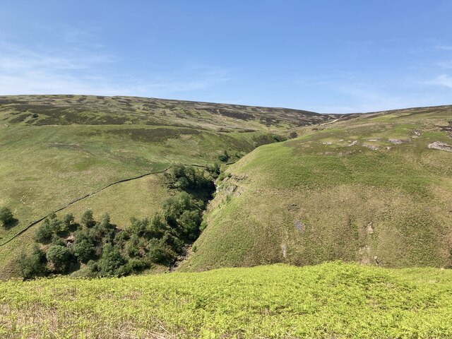
Blakethwaite Moss is a captivating area located in Yorkshire, England, renowned for its picturesque landscapes and diverse ecosystems. Situated amidst the beautiful Yorkshire Downs and Moorland, this region is a haven for nature enthusiasts and offers a unique blend of natural beauty and tranquility.

Covering a vast expanse of land, Blakethwaite Moss is characterized by its rolling hills, heather-covered moorland, and scattered clusters of trees. The area is home to a wide variety of flora and fauna, including heather, bilberry, and cotton grass, which blossom in vibrant hues during the summer months.

The diverse wildlife found in Blakethwaite Moss includes red grouse, curlews, and lapwings, making it a popular destination for birdwatchers. Additionally, the region is home to several grazing animals such as sheep and ponies, which contribute to the preservation of the unique ecosystem.

Blakethwaite Moss offers numerous opportunities for outdoor activities, including hiking, cycling, and wildlife spotting. Visitors can explore the network of trails that crisscross the area, offering breathtaking views of the surrounding countryside. The tranquil atmosphere and untouched beauty of Blakethwaite Moss make it an ideal location for those seeking respite from the bustling city life.

The region's rich history is also evident, with remnants of ancient stone circles and burial mounds scattered throughout the area. These archaeological sites provide a glimpse into the lives of the early inhabitants of Blakethwaite Moss.

Overall, Blakethwaite Moss is a captivating destination that showcases the natural beauty and diverse ecosystems of Yorkshire's Downs and Moorland. Whether one seeks adventure, tranquility, or a deeper connection with nature, this area offers a unique and rewarding experience.

If you have any feedback on the listing, please let us know in the comments section below.

Blakethwaite Moss Images

Images are sourced within 2km of 54.417404/-2.1032272 or Grid Reference NY9302. Thanks to Geograph Open Source API. All images are credited.

Blakethwaite Gill of Gunnerside Moor Snow cover over the hills of Swaledale with Blakethwaite Gill below the shooting hut in the foreground. The lower part of the valley is Gunnerside Gill which empties its water into the River Swale.
Blakethwaite Gill of Gunnerside Moor
Snow cover over the hills of Swaledale with Blakethwaite Gill below the shooting hut in the foreground. The lower part of the valley is Gunnerside Gill which empties its water into the River Swale.
Summit cairn at Rogan's Seat
Gate across estate road on Rogan's Seat The road is a disgracefully bulldozed scar right across the summit area of one of the highest hills of the Yorkshire Dales National Park! It's there simply to convey 'guns' to the butts further along the moor where there was also a shooting hut, but aerial imagery suggests that it's no longer there.
The snowed hills in the distance are Little Fell and Mickle Fell.
Gate across estate road on Rogan's Seat
The road is a disgracefully bulldozed scar right across the summit area of one of the highest hills of the Yorkshire Dales National Park! It's there simply to convey 'guns' to the butts further along the moor where there was also a shooting hut, but aerial imagery suggests that it's no longer there. The snowed hills in the distance are Little Fell and Mickle Fell.
Looking up Gunnerside Gill Showing the remains of old lead mine workings on both sides
Looking up Gunnerside Gill
Showing the remains of old lead mine workings on both sides
The path up Gunnerside Gill at Swina Bank
Botcher Gill
Botcher Gill
Entrance to Bunton Level lead mine
Ruined buildings at Bunton Level lead mine
Old lead mining area in Gunnerside Gill The North Hush and Lownathwaite Lead Mine
Old lead mining area in Gunnerside Gill
The North Hush and Lownathwaite Lead Mine
Dolly Lead Level The stone entrance to the Dolly Lead Level can be seen sitting above the mining waste tumbling into the Gunnerside valley as if spewed from the mouth of the level.
Dolly Lead Level
The stone entrance to the Dolly Lead Level can be seen sitting above the mining waste tumbling into the Gunnerside valley as if spewed from the mouth of the level.
Bunton Level and Bunton Hush Bunton level is one of many levels and shafts associated with Friarfold Lead Mine. There are also three hushes in close proximity around the mine site. Hushes were created by the damming and releasing of water to sweep away the upper layers of vegetation and expose the veins of ore.
Bunton Level and Bunton Hush
Bunton level is one of many levels and shafts associated with Friarfold Lead Mine. There are also three hushes in close proximity around the mine site. Hushes were created by the damming and releasing of water to sweep away the upper layers of vegetation and expose the veins of ore.
Mine Buildings, Bunton Level, and Bunton Hush Buildings, level, and hush associated with the Friarfold lead mine.
Mine Buildings, Bunton Level, and Bunton Hush
Buildings, level, and hush associated with the Friarfold lead mine.
Waterfall and old mine workings, Blakethwaite Gill
Ruins of Blakethwaite Smelting Mill Lead ore was smelted here from 1821. The closure date is disputed, with 1878 being the most often quoted year. The lead was smelted using peat with a little coal. The arched building in the foreground was probably for peat storage, the furnace was part of the ruin seen at the base of the hill, with the route of the flue traceable up the hillside to a now demolished chimney. Just behind and above the furnace ruin is a lime kiln, most likely built to provide the mortar for constructing  the rest of the buildings on the site.
Ruins of Blakethwaite Smelting Mill
Lead ore was smelted here from 1821. The closure date is disputed, with 1878 being the most often quoted year. The lead was smelted using peat with a little coal. The arched building in the foreground was probably for peat storage, the furnace was part of the ruin seen at the base of the hill, with the route of the flue traceable up the hillside to a now demolished chimney. Just behind and above the furnace ruin is a lime kiln, most likely built to provide the mortar for constructing the rest of the buildings on the site.
Entrance to Bunton Level I've taken the 8-figure grid reference for this by comparison with Andy Waddington's photo <a href="https://www.geograph.org.uk/photo/4702388">NY9401 : Bunton Hush above the entrance to Bunton Level</a> slightly adjusted from looking at aerial mapping.
Entrance to Bunton Level
I've taken the 8-figure grid reference for this by comparison with Andy Waddington's photo NY9401 : Bunton Hush above the entrance to Bunton Level slightly adjusted from looking at aerial mapping.
Boundary stone near to Great Punchard Head Great Punchard Head is an area of moorland drained by a number of minor streams that combine to form Great Punchard Gill. The boundary stone is one of a number marked on OS maps running (initially) near to east from Water Crag.
Boundary stone near to Great Punchard Head
Great Punchard Head is an area of moorland drained by a number of minor streams that combine to form Great Punchard Gill. The boundary stone is one of a number marked on OS maps running (initially) near to east from Water Crag.
Fingerpost, Gunnerside Gill Marooned in a sea of waste from the old lead workings. Surrender Bridge lies across the moor, the next objective for Coast-to-Coast walkers.
Fingerpost, Gunnerside Gill
Marooned in a sea of waste from the old lead workings. Surrender Bridge lies across the moor, the next objective for Coast-to-Coast walkers.
Show me another place!

Blakethwaite Moss is located at Grid Ref: NY9302 (Lat: 54.417404, Lng: -2.1032272)

Division: North Riding

Administrative County: North Yorkshire

District: Richmondshire

Police Authority: North Yorkshire

What 3 Words

///emperor.leopard.obviously. Near Bowes, Co. Durham

Related Wikis

Rogan's Seat

Rogan's Seat is a remote hill located near East Stonesdale and Gunnerside Gill, in the Yorkshire Dales in England. It is a high expanse of moorland that...

Arkengarthdale Gunnerside and Reeth Moors

Arkengarthdale Gunnerside and Reeth Moors (grid reference NY935070 and SD970990) is a 7,634.72 hectares (18,865.8 acres) biological Site of Special Scientific...

Gunnerside Gill

Gunnerside Gill (or Ghyll) is a small valley in the Yorkshire Dales, England, which branches off Swaledale into moorland to the north of Gunnerside. The...

Melbecks

Melbecks is a civil parish in North Yorkshire, England. It is located in upper Swaledale and covers the settlements of Gunnerside, Low Row, Feetham and...

Kisdon Force

Kisdon Force is a series of waterfalls on the River Swale in Swaledale, England. The falls are situated within the Yorkshire Dales National Park in the...

East Gill Force

East Gill Force is a waterfall in Swaledale, 330 yards (300 m) east of the hamlet of Keld, in the Yorkshire Dales National Park, North Yorkshire, England...

Arn Gill (North Yorkshire)

Arn Gill is a ravine or gully containing a beck of the same name, near the village of Muker in Swaledale, North Yorkshire, England. The ravine and beck...

Keld, North Yorkshire

Keld is a village in the English county of North Yorkshire. It is in Swaledale, and the Yorkshire Dales National Park. The name derives from the Viking...

Nearby Amenities

Located within 500m of 54.417404,-2.1032272
Blakethwaite Gill
Place: locality
Source: Bing
Lat/Long: 54.4209699/-2.0990615
Orton Hull
Place: locality
Source: Bing
Lat/Long: 54.4212576/-2.1063933
Eweleap Scar
Place: locality
Source: Bing
Lat/Long: 54.4170038/-2.0959919
Disused: yes
Man Made: chimney
Lat/Long: 54.4132277/-2.1005235
The data included in this document is from www.openstreetmap.org. The data is made available under ODbL.

Have you been to Blakethwaite Moss?

Leave your review of Blakethwaite Moss below (or comments, questions and feedback).