Aid Moss

Downs, Moorland in Northumberland

England

Aid Moss

Minor road leaving Sarelaw Towards Knowesgate.
Minor road leaving Sarelaw Credit: JThomas

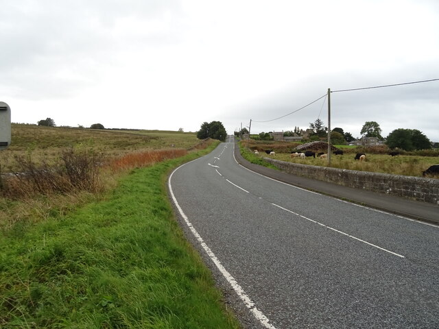
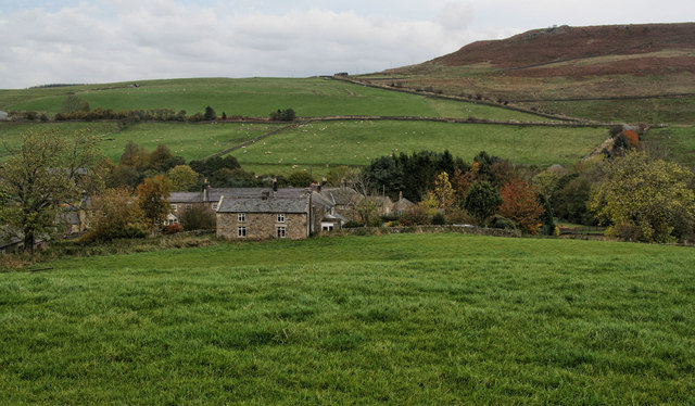
Aid Moss is a vast expanse of natural beauty located in Northumberland, England. Stretching across the Downs and Moorland areas, this unique landscape offers a diverse range of flora and fauna, making it an ideal destination for nature enthusiasts and outdoor adventurers alike.

Covering an area of approximately 1,500 hectares, Aid Moss is characterized by its wetland habitats, including peat bogs, marshes, and shallow pools. These wetlands provide a crucial ecosystem for numerous plant and animal species, some of which are rare and endangered.

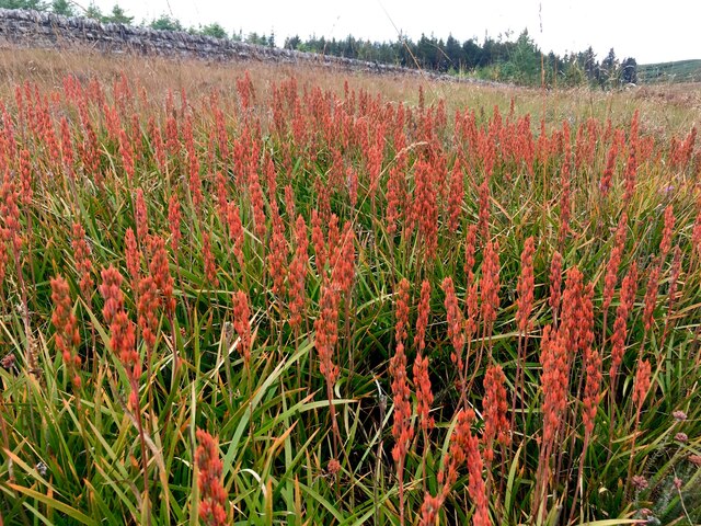
The moss is home to a variety of plant life, with heather, bog cotton, and sphagnum moss dominating the terrain. These plants thrive in the acidic conditions created by the high peat content of the soil. In addition to the rich vegetation, Aid Moss also boasts a significant diversity of bird species, including curlews, lapwings, and red grouse. These birds can often be heard singing and seen soaring above the moss.

For those interested in exploring the area, Aid Moss offers several walking trails and birdwatching spots. The trails wind through the moorland, providing breathtaking views of the surrounding countryside. Visitors can also enjoy the peacefulness of the moss by simply sitting back and observing the diverse wildlife that calls this place home.

Overall, Aid Moss in Northumberland is a natural treasure, showcasing the beauty and importance of wetland ecosystems. It offers visitors a chance to immerse themselves in nature and appreciate the wonders of this unique landscape.

If you have any feedback on the listing, please let us know in the comments section below.

Aid Moss Images

Images are sourced within 2km of 55.146227/-2.1219081 or Grid Reference NY9283. Thanks to Geograph Open Source API. All images are credited.

Minor road leaving Sarelaw Towards Knowesgate.
Minor road leaving Sarelaw
Towards Knowesgate.
Low House On the A68.
Low House
On the A68.
Rough grazing near the Chesterhope Burn Off the A68.
Rough grazing near the Chesterhope Burn
Off the A68.
A68 towards Ridsdale
Houses on Westmacott Street (A68), Ridsdale
Westmacott Street (A68), Ridsdale
Victorian postbox on Westmacott Street (A68), Ridsdale Postbox No. NE48 5.
Victorian postbox on Westmacott Street (A68), Ridsdale
Postbox No. NE48 5.
The Gun, Ridsdale
The Gun, Ridsdale
Sign on the Gun, Ridsdale
Rough grazing and woodland, Chesterhope Common
Track into woodland, Chesterhope Common Off the A68.
Track into woodland, Chesterhope Common
Off the A68.
A68 heading south  Towards Swinburne.
A68 heading south
Towards Swinburne.
Maturing Bog Asphodel A spectacular and colourful patch of Bog Asphodel (Narthecium Ossifragum).
Maturing Bog Asphodel
A spectacular and colourful patch of Bog Asphodel (Narthecium Ossifragum).
Ironworks Spoil Heaps
Terraced Housing, Armstrong Street, Ridsdale.
Robertson Street, Ridsdale
The Gun, Ridsdale In 2020, it looked odds on that Ridsdale’s last public amenity – The Gun – would be sold to housing developers, so villagers formed the Ridsdale Community Group with the aim of saving the pub.

After a successful social media campaign, driven on twitter by wonderful crime writers such as Ian Rankin, Mari Hannah and Ann Cleeves plus a double page spread in the Observer (and subsequently The Guardian website) we raised in excess of £200,000.

Our community benefit society now has hundreds of shareholders from all around the world.  Volunteers from the village spent over 20,000 hours renovating and refurbishing the pub during 2020, and we opened our doors in May 2021.

As a community benefit society, it is our aim to make The Gun much more than just a pub – it must also be a resource for the local community. Plans for The Gun include a library, a free-to-use computer with internet access and a parcel pick-up point.
<span class="nowrap"><a title="https://thegunatridsdale.co.uk/" rel="nofollow ugc noopener" href="https://thegunatridsdale.co.uk/">Link</a><img style="margin-left:2px;" alt="External link" title="External link - shift click to open in new window" src="https://s1.geograph.org.uk/img/external.png" width="10" height="10"/></span>
The Gun, Ridsdale
In 2020, it looked odds on that Ridsdale’s last public amenity – The Gun – would be sold to housing developers, so villagers formed the Ridsdale Community Group with the aim of saving the pub. After a successful social media campaign, driven on twitter by wonderful crime writers such as Ian Rankin, Mari Hannah and Ann Cleeves plus a double page spread in the Observer (and subsequently The Guardian website) we raised in excess of £200,000. Our community benefit society now has hundreds of shareholders from all around the world. Volunteers from the village spent over 20,000 hours renovating and refurbishing the pub during 2020, and we opened our doors in May 2021. As a community benefit society, it is our aim to make The Gun much more than just a pub – it must also be a resource for the local community. Plans for The Gun include a library, a free-to-use computer with internet access and a parcel pick-up point. LinkExternal link
Ridsdale Ironworks Engine House his ironworks was established in 1836 using local sources of ironstone. The works consisted of three furnaces, an engine house, coke ovens, calcining kilns and reservoirs. A series of tramways linked the site with nearby sources of ironstone, limestone and coal. By 1848 the ironworks had virtually closed and in 1864 two of the furnaces were dismantled and taken to W.G. Armstrong's works in Elswick, Newcastle. This was a short-lived venture and part of a largely unsuccessful 19th century iron industry in Northumberland. However, many features of this remote ironworks works can still be seen and survive relatively intact, either as standing ruins or earthworks. This is a Scheduled Monument and Grade II Listed Building protected by law.
<span class="nowrap"><a title="https://keystothepast.info/search-records/results-of-search/results-of-search-2/site-details/?PRN=N9505" rel="nofollow ugc noopener" href="https://keystothepast.info/search-records/results-of-search/results-of-search-2/site-details/?PRN=N9505">Link</a><img style="margin-left:2px;" alt="External link" title="External link - shift click to open in new window" src="https://s1.geograph.org.uk/img/external.png" width="10" height="10"/></span>
Ridsdale Ironworks Engine House
his ironworks was established in 1836 using local sources of ironstone. The works consisted of three furnaces, an engine house, coke ovens, calcining kilns and reservoirs. A series of tramways linked the site with nearby sources of ironstone, limestone and coal. By 1848 the ironworks had virtually closed and in 1864 two of the furnaces were dismantled and taken to W.G. Armstrong's works in Elswick, Newcastle. This was a short-lived venture and part of a largely unsuccessful 19th century iron industry in Northumberland. However, many features of this remote ironworks works can still be seen and survive relatively intact, either as standing ruins or earthworks. This is a Scheduled Monument and Grade II Listed Building protected by law. LinkExternal link
Show me another place!

Aid Moss is located at Grid Ref: NY9283 (Lat: 55.146227, Lng: -2.1219081)

Unitary Authority: Northumberland

Police Authority: Northumbria

What 3 Words

///pizzeria.offstage.smooth. Near Corsenside, Northumberland

Nearby Locations

Aid Moss

Related Wikis

Have you been to Aid Moss?

Leave your review of Aid Moss below (or comments, questions and feedback).