Burnhope Pastures

Downs, Moorland in Durham

England

Burnhope Pastures

Low water in Burnhope Reservoir The reservoir in upper Weardale during August 2022, following an extended period of low rainfall.
Burnhope Seat is the hill on the horizon, its summit area being cloud-shadowed, left of centre.
Low water in Burnhope Reservoir Credit: Trevor Littlewood

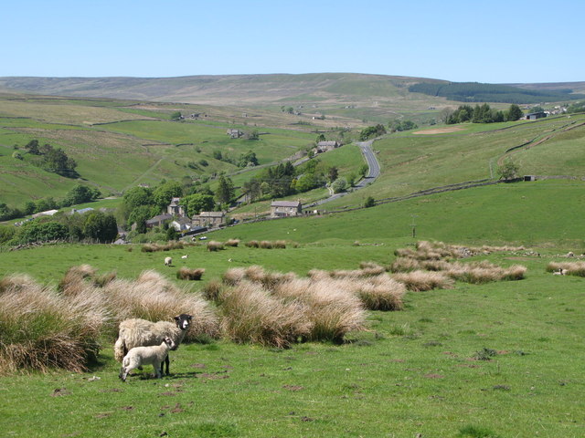
Burnhope Pastures is a vast expanse of moorland located in County Durham, England. Situated between the villages of Burnhope and Lanchester, this area is a designated Site of Special Scientific Interest (SSSI). The moorland covers an impressive area of approximately 1,200 hectares and is known for its outstanding natural beauty and diverse wildlife.

The landscape of Burnhope Pastures is characterized by rolling hills, heather-clad moors, and deep valleys, creating a picturesque setting for visitors to explore. The area is mostly uninhabited, providing a tranquil and remote location for those seeking solitude and a connection with nature.

The moorland is home to a variety of flora and fauna, with some species being unique to this particular habitat. Heather dominates the landscape, creating a striking purple carpet during the summer months. Other plants that thrive in this environment include bilberry, crowberry, and cotton grass. The moorland also supports several bird species, including curlews, lapwings, and red grouse, making it a haven for birdwatchers.

Burnhope Pastures offers numerous walking and hiking trails, allowing visitors to explore the stunning surroundings and take in the panoramic views of the surrounding countryside. The area is also popular for grouse shooting and is a designated area for scientific research due to its ecological importance.

In conclusion, Burnhope Pastures in Durham is a magnificent moorland that boasts breathtaking natural beauty, diverse wildlife, and ample opportunities for outdoor activities.

If you have any feedback on the listing, please let us know in the comments section below.

Burnhope Pastures Images

Images are sourced within 2km of 54.746988/-2.2537887 or Grid Reference NY8339. Thanks to Geograph Open Source API. All images are credited.

Low water in Burnhope Reservoir The reservoir in upper Weardale during August 2022, following an extended period of low rainfall.
Burnhope Seat is the hill on the horizon, its summit area being cloud-shadowed, left of centre.
Low water in Burnhope Reservoir
The reservoir in upper Weardale during August 2022, following an extended period of low rainfall. Burnhope Seat is the hill on the horizon, its summit area being cloud-shadowed, left of centre.
Path on north side of Burnhope Reservoir Maps show that if full the reservoir's water would reach close to the path. That's far from the situation in mid-August 2022 when the water level was well down.
It seems that the reservoir is not now used as a direct supply source for homes or industry but to top up when necessary, water flow in the River Wear.
Path on north side of Burnhope Reservoir
Maps show that if full the reservoir's water would reach close to the path. That's far from the situation in mid-August 2022 when the water level was well down. It seems that the reservoir is not now used as a direct supply source for homes or industry but to top up when necessary, water flow in the River Wear.
Pipeline crossing valley of Black Cleugh Being so close to Burnhope Reservoir it's assumed that the pipe carries water either to or from there. Both the pipe and the reservoir surface are close to the 400 m. contour so it's unclear in which direction, (if under gravity), water would flow.
Pipeline crossing valley of Black Cleugh
Being so close to Burnhope Reservoir it's assumed that the pipe carries water either to or from there. Both the pipe and the reservoir surface are close to the 400 m. contour so it's unclear in which direction, (if under gravity), water would flow.
Sheep on moorland beside Grasshill Causeway Four animals, (there are four), just south-east of the public road at over 500 m. above sea level. Noon Hill is in the distance beyond the valley of the Ireshope Burn.
Sheep on moorland beside Grasshill Causeway
Four animals, (there are four), just south-east of the public road at over 500 m. above sea level. Noon Hill is in the distance beyond the valley of the Ireshope Burn.
Dam and spillway at Burnhope Reservoir at time of low water Despite some heavy rain in the first half of September 2022 after an extended dry spell, the water level at the Burnhope Reservoir remains very low. Were the reservoir full, excess water would be dropping over the lip of the spillway and cascading down the steps to run down and join the River Wear in the valley below.
Dam and spillway at Burnhope Reservoir at time of low water
Despite some heavy rain in the first half of September 2022 after an extended dry spell, the water level at the Burnhope Reservoir remains very low. Were the reservoir full, excess water would be dropping over the lip of the spillway and cascading down the steps to run down and join the River Wear in the valley below.
Burnhope Burn running into Burnhope Reservoir. The water level in the reservoir is well below capacity following a long dry spell of weather during the summer. Certainly, if it was full, its water would cover the distant vegetated area at the centre of the image.
Burnhope Burn running into Burnhope Reservoir.
The water level in the reservoir is well below capacity following a long dry spell of weather during the summer. Certainly, if it was full, its water would cover the distant vegetated area at the centre of the image.
Rough Sike Rough Sike descending towards Burnhope Reservoir which it will reach having merged with the greater stream, Langtae Burn. The reservoir can be seen to be in need of all the water it can get - the level is dramatically low!

Note: A sike, according to Oxford Dictionaries, is... "a small stream or rill, typically one that flows through marshy ground and is often dry in summer"; the term is of Scottish and northern English usage.
Rough Sike
Rough Sike descending towards Burnhope Reservoir which it will reach having merged with the greater stream, Langtae Burn. The reservoir can be seen to be in need of all the water it can get - the level is dramatically low! Note: A sike, according to Oxford Dictionaries, is... "a small stream or rill, typically one that flows through marshy ground and is often dry in summer"; the term is of Scottish and northern English usage.
Hill road leaving Grasshill Causeway The rough road appears to be heading for High House but it doesn't go directly there, instead it veers to the left to reach another building, not in view in the image, Far High House. Neither property is occupied.
Hill road leaving Grasshill Causeway
The rough road appears to be heading for High House but it doesn't go directly there, instead it veers to the left to reach another building, not in view in the image, Far High House. Neither property is occupied.
Hill road at Peatcleugh Sike The stream, Peatcleugh Sike is crossed at the road bend. The road is also the route of a bridleway.
Hill road at Peatcleugh Sike
The stream, Peatcleugh Sike is crossed at the road bend. The road is also the route of a bridleway.
Icy road passing Slack House The rough potholed road gives access to Slack House and another building then heads into the moorland above the west side of Ires Hope; it's also the route of a bridleway.
Icy road passing Slack House
The rough potholed road gives access to Slack House and another building then heads into the moorland above the west side of Ires Hope; it's also the route of a bridleway.
Wall with gate across icy hill road The rough road, also a bridleway, is above the western side of the valley of Ires Hope. It continues for some distance behind the camera position, deteriorating eventually and ends on open moorland at Wham Pasture. 
The enclosure beyond the left side wall is in use by Northumbrian Water and has a number of settling ponds marked on OS, 1:25 000 maps.
The distant moorland is Black Hill.
Wall with gate across icy hill road
The rough road, also a bridleway, is above the western side of the valley of Ires Hope. It continues for some distance behind the camera position, deteriorating eventually and ends on open moorland at Wham Pasture. The enclosure beyond the left side wall is in use by Northumbrian Water and has a number of settling ponds marked on OS, 1:25 000 maps. The distant moorland is Black Hill.
Fence and moorland in upper Weardale Just off Grasshill Causeway.
Fence and moorland in upper Weardale
Just off Grasshill Causeway.
Track to High House Farm Leading off Grasshill Causeway. The plantations surrounding the Burnhope Reservoir <a href="https://www.geograph.org.uk/gridref/NY8438">NY8438</a> lie beyond.
Track to High House Farm
Leading off Grasshill Causeway. The plantations surrounding the Burnhope Reservoir NY8438 lie beyond.
Gate at the start of Grasshill Causeway A very rough road which runs from Ireshopeburn in Weardale over to Grass Hill Farm at the head of Teesdale. At one time, the road served the lead mines in the vicinity and still carries the status of public highway. At this point, the road is rough tarmac, but the tarmac gives out a little over a kilometres further uphill.
Gate at the start of Grasshill Causeway
A very rough road which runs from Ireshopeburn in Weardale over to Grass Hill Farm at the head of Teesdale. At one time, the road served the lead mines in the vicinity and still carries the status of public highway. At this point, the road is rough tarmac, but the tarmac gives out a little over a kilometres further uphill.
Slack House Farm Farm on the edge of the moor above Ireshopeburn in upper Weardale.
Slack House Farm
Farm on the edge of the moor above Ireshopeburn in upper Weardale.
Burnhope Reservoir The water treatment works at Burnhope Reservoir seen from on top of the dam.
Burnhope Reservoir
The water treatment works at Burnhope Reservoir seen from on top of the dam.
Road north of Blackcleugh Upper Weardale has a number of minor roads on slopes above the valley bottom. This one if followed behind the camera position leads to Burnhope Reservoir.
Road north of Blackcleugh
Upper Weardale has a number of minor roads on slopes above the valley bottom. This one if followed behind the camera position leads to Burnhope Reservoir.
Ruin near Cleugh Head Cleugh Head is a vague location on the broad moorland ridge running eastwards into Weardale from Highwatch Currick. The feature does indeed appear to be a ruin, (rather than simply a stone pile), as certain corner stones appear to have been shaped for their purpose. The view beyond is to the south-east, into Weardale with Chapel Fell showing most obviously among the moorlands of its south side.
Ruin near Cleugh Head
Cleugh Head is a vague location on the broad moorland ridge running eastwards into Weardale from Highwatch Currick. The feature does indeed appear to be a ruin, (rather than simply a stone pile), as certain corner stones appear to have been shaped for their purpose. The view beyond is to the south-east, into Weardale with Chapel Fell showing most obviously among the moorlands of its south side.
Show me another place!

Burnhope Pastures is located at Grid Ref: NY8339 (Lat: 54.746988, Lng: -2.2537887)

Unitary Authority: County Durham

Police Authority: Durham

What 3 Words

///baseballs.lied.pythons. Near Alston, Cumbria

Nearby Locations

Burnhope Pastures

Related Wikis

Far High House Meadows

Far High House Meadows is a Site of Special Scientific Interest in Upper Weardale in west County Durham, England. It consists of three fields, located...

Burnhope Reservoir railway

The Burnhope Reservoir railway was an industrial narrow gauge railway built to serve the construction of Burnhope Reservoir near Weardale. An extensive...

Wearhead

Wearhead is a village in the civil parish of Stanhope, in County Durham, England. It is situated at the top of Weardale between Cowshill and Ireshopeburn...

Cowshill

Cowshill is a village in the civil parish of Stanhope, in County Durham, England. It is situated at the top of Weardale, between Lanehead and Wearhead...

Copthill

Copthill is a village in the civil parish of Stanhope, in County Durham, England. It is situated on the north side of Weardale, between Cowshill and Cornriggs...

New House, County Durham

New House or Newhouse is a hamlet in the civil parish of Stanhope, in County Durham, England. It lies on the north side of the River Wear, opposite Ireshopeburn...

Wearhead railway station

Wearhead railway station served the village of Wearhead, County Durham, England, from 1895 to 1961 on the Weardale Railway. == History == The station opened...

Cornriggs

Cornriggs is a hamlet in the civil parish of Stanhope, in County Durham, England. It is situated on the north side of Weardale in the North Pennines,...

Nearby Amenities

Located within 500m of 54.746988,-2.2537887
Barrier: entrance
Lat/Long: 54.7489755/-2.247034
Leisure: picnic_table
Material: wood
Lat/Long: 54.7453033/-2.2492678
Leisure: picnic_table
Material: wood
Lat/Long: 54.7451282/-2.2510566
The data included in this document is from www.openstreetmap.org. The data is made available under ODbL.

Have you been to Burnhope Pastures?

Leave your review of Burnhope Pastures below (or comments, questions and feedback).