East Baugh Fell

Downs, Moorland in Yorkshire South Lakeland

England

East Baugh Fell

Animal trap on log on top of dry stone wall at White Mea Apparently weasels have to be killed so that they do not predate grouse which have to be protected to be shot for sport.
Animal trap on log on top of dry stone wall at White Mea Credit: Luke Shaw

East Baugh Fell is a sprawling area of natural beauty located in Yorkshire, England. Situated in the heart of the Yorkshire Dales National Park, it is renowned for its stunning downs and vast moorland landscapes. Covering an area of approximately 10 square kilometers, East Baugh Fell offers visitors a unique opportunity to immerse themselves in the tranquility of nature.

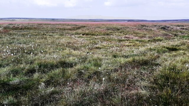
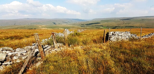
The terrain of East Baugh Fell is characterized by undulating hills, open grasslands, and heather-covered moorlands. The area is rich in biodiversity, with a variety of plant and animal species calling it home. Visitors can expect to encounter a range of wildlife, including red grouse, curlews, and the occasional golden eagle soaring above.

For outdoor enthusiasts, East Baugh Fell offers numerous walking and hiking trails that cater to all skill levels. The paths meander through the picturesque countryside, providing breathtaking views of the surrounding valleys and hills. Additionally, the moorland provides an ideal setting for activities such as birdwatching and photography.

Despite its remote location, East Baugh Fell is easily accessible by road, with a well-maintained car park located nearby. The area is a popular destination for nature lovers, photographers, and those seeking a peaceful retreat away from the hustle and bustle of everyday life.

East Baugh Fell is a true gem of Yorkshire, offering visitors a glimpse into the region's natural beauty. Whether it's exploring the vast moorland or simply taking in the breathtaking views, a visit to East Baugh Fell is sure to leave a lasting impression.

If you have any feedback on the listing, please let us know in the comments section below.

East Baugh Fell Images

Images are sourced within 2km of 54.325815/-2.3812176 or Grid Reference SD7592. Thanks to Geograph Open Source API. All images are credited.

Animal trap on log on top of dry stone wall at White Mea Apparently weasels have to be killed so that they do not predate grouse which have to be protected to be shot for sport.
Animal trap on log on top of dry stone wall at White Mea
Apparently weasels have to be killed so that they do not predate grouse which have to be protected to be shot for sport.
Moorland view at Ceaseat Mire There is a patch of moorland plants with yellow flowers in the middle of the image
Moorland view at Ceaseat Mire
There is a patch of moorland plants with yellow flowers in the middle of the image
View into Coat Weggs forestry from NE
Limekiln near spring on south side of East Baugh Fell
Looking south towards Garsdale along dry stone wall at Green Side
Junction of dry stone walls below Tarn Rigg Hill. View over Garsdale
Line of rocks below Tan Rigg Hill
Thistles in spring channel north of Coat Weggs forestry A limekiln beyond the spring source
Thistles in spring channel north of Coat Weggs forestry
A limekiln beyond the spring source
Moorland path on Green Side
Looking north along dry stone wall on south side of East Baugh Fell
Small cairn on Tarn Rigg Hill Maps show a spot height of 678m here
Small cairn on Tarn Rigg Hill
Maps show a spot height of 678m here
View towards East Tarns from Tarn Rigg Hill Rushy moorland with cotton grass
View towards East Tarns from Tarn Rigg Hill
Rushy moorland with cotton grass
Grouse grit box on East Baugh Fell
Gap in dry stone wall for quad bike track
Descending from West Baugh Fell heading for Garsdale Head
Tarn of the East Tarns group on Baugh Fell The frozen tarn is unnamed individually. It lies to the north of Tarn Rigg Hill which is the higher of the two tops of Baugh Fell. This tarn is the most westerly of the group.
The Howgill Fells can just be seen above the far shore and much more distantly, Lake District mountains can be discerned too.
Tarn of the East Tarns group on Baugh Fell
The frozen tarn is unnamed individually. It lies to the north of Tarn Rigg Hill which is the higher of the two tops of Baugh Fell. This tarn is the most westerly of the group. The Howgill Fells can just be seen above the far shore and much more distantly, Lake District mountains can be discerned too.
White Mea Rough going on our Baugh Fell walk.
White Mea
Rough going on our Baugh Fell walk.
Fence and tumbled-down wall on East Baugh Fell Walking the Dales 30s.
Fence and tumbled-down wall on East Baugh Fell
Walking the Dales 30s.
Show me another place!

East Baugh Fell is located at Grid Ref: SD7592 (Lat: 54.325815, Lng: -2.3812176)

Division: West Riding

Administrative County: Cumbria

District: South Lakeland

Police Authority: Cumbria

What 3 Words

///argue.reboot.grumbles. Near Sedbergh, Cumbria

Nearby Locations

East Baugh Fell

Related Wikis

Baugh Fell

Baugh Fell (, or locally ) is a large, flat-topped hill in the northern Pennines of England. It lies in the north-western corner of the Yorkshire Dales...

Grisedale

Grisedale (sometimes Grisdale, or Grizedale [archaic]) is a south east facing Dale in Cumbria, England, 8 miles (13 km) east of Sedbergh, and 7 miles...

Garsdale

Garsdale is a dale or valley in the south east of Cumbria, England, historically a part of the West Riding of Yorkshire. It is now within the Westmorland...

Garsdale Head

Garsdale Head is a hamlet mainly within the South Lakeland district of Cumbria, England. Historically part of the West Riding of Yorkshire, the hamlet...

Rise Hill Tunnel

Rise Hill Tunnel is a 1,213-yard (1,109 m) long tunnel that takes the Settle–Carlisle line beneath Black Moss in Cumbria, England. It is the second longest...

Garsdale railway station

Garsdale is a railway station in Cumbria, England (historically in the West Riding of Yorkshire), on the Settle and Carlisle Line, which runs between Carlisle...

Hawes Junction rail crash

The Hawes Junction rail crash occurred at 5.49 am on 24 December 1910, just north of Lunds Viaduct between Hawes Junction (now known as Garsdale station...

Dandry Mire Viaduct

Dandry Mire Viaduct, (or Dandrymire Viaduct), is a railway viaduct on the Settle & Carlisle line in Cumbria, England. It is just north of Garsdale station...

Nearby Amenities

Located within 500m of 54.325815,-2.3812176
Man Made: cairn
Lat/Long: 54.3271563/-2.3769388
Man Made: cairn
Lat/Long: 54.3271989/-2.3767825
Man Made: cairn
Lat/Long: 54.3272134/-2.376649
Man Made: cairn
Lat/Long: 54.3273776/-2.3762696
Man Made: cairn
Lat/Long: 54.3271928/-2.3763738
Man Made: cairn
Lat/Long: 54.3271162/-2.3766386
Man Made: cairn
Lat/Long: 54.327059/-2.3767929
Man Made: cairn
Lat/Long: 54.3269837/-2.3767387
Man Made: cairn
Lat/Long: 54.3270274/-2.3765802
Man Made: cairn
Lat/Long: 54.3270675/-2.3764447
Man Made: cairn
Lat/Long: 54.3271381/-2.3764676
Man Made: cairn
Lat/Long: 54.3271247/-2.3765281
Grisedale Pike
Natural: peak
Lat/Long: 54.3270809/-2.3769076
The data included in this document is from www.openstreetmap.org. The data is made available under ODbL.

Have you been to East Baugh Fell?

Leave your review of East Baugh Fell below (or comments, questions and feedback).