Austwick Common

Downs, Moorland in Yorkshire Craven

England

Austwick Common

Moorland road north of Bowland Knotts On the horizon are the 'Three Peaks' of Yorkshire.
Moorland road north of Bowland Knotts Credit: John H Darch

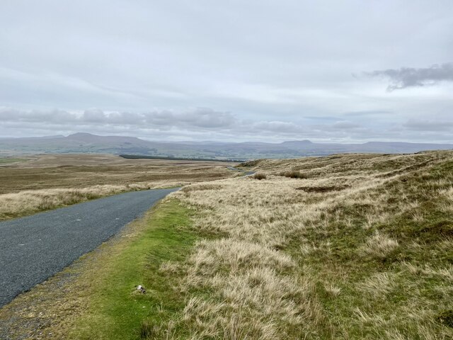
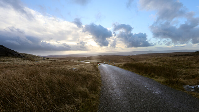
Austwick Common is a picturesque area located in the heart of the Yorkshire Dales in North Yorkshire, England. Covering an area of approximately 200 acres, this vast expanse of land is a combination of rolling downs and expansive moorland. The common is situated just outside the village of Austwick and is a popular destination for hikers, nature enthusiasts, and outdoor adventurers.

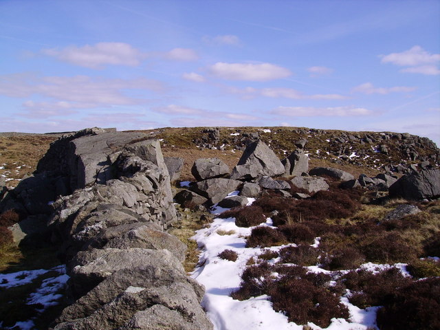
The landscape of Austwick Common is characterized by its sweeping vistas, with lush green fields, rocky outcrops, and heather-covered moorlands. The area is crisscrossed by a network of footpaths and bridleways, allowing visitors to explore its beauty on foot, on horseback, or by bicycle. The terrain is varied, offering opportunities for both leisurely walks and more challenging hikes.

The common is also home to a rich array of flora and fauna, including a variety of wildflowers, mosses, and grasses that carpet the land in vibrant colors during the summer months. The area attracts a diverse range of bird species, making it a haven for birdwatchers, while mammals such as hares, rabbits, and deer can often be spotted amid the greenery.

Visitors to Austwick Common can enjoy stunning views of the surrounding Yorkshire Dales, including the famous Three Peaks – Ingleborough, Whernside, and Pen-y-ghent. The common offers a tranquil retreat from the hustle and bustle of city life, providing a place for visitors to reconnect with nature and experience the beauty of the Yorkshire countryside.

If you have any feedback on the listing, please let us know in the comments section below.

Austwick Common Images

Images are sourced within 2km of 54.051849/-2.401279 or Grid Reference SD7361. Thanks to Geograph Open Source API. All images are credited.

Moorland road north of Bowland Knotts On the horizon are the 'Three Peaks' of Yorkshire.
Moorland road north of Bowland Knotts
On the horizon are the 'Three Peaks' of Yorkshire.
Keasden road heads down Crutchenber Fell Despite rain overngight and an unpromising sky in the morning, the weather is clearing up enough for a good day out in Gisburn Forest. The Keasden road crosses the watershed at Bowland Knotts and heads south for the forest and Stocks reservoir en route for Slaidburn. This used to be a very quiet road when last I passed this way (probably thirty years ago) but now carries a lot of people to the extensive carparks, paths and bike trails provided by the forestry and water companies.
Keasden road heads down Crutchenber Fell
Despite rain overngight and an unpromising sky in the morning, the weather is clearing up enough for a good day out in Gisburn Forest. The Keasden road crosses the watershed at Bowland Knotts and heads south for the forest and Stocks reservoir en route for Slaidburn. This used to be a very quiet road when last I passed this way (probably thirty years ago) but now carries a lot of people to the extensive carparks, paths and bike trails provided by the forestry and water companies.
Knotteranum From the wall on Bowland Knotts
Knotteranum
From the wall on Bowland Knotts
From Rock Cat Knott There are several massive boulders in the wall from Knotteranum. Looking towards Halstead Fell over the trench of Brock Clough beck.
From Rock Cat Knott
There are several massive boulders in the wall from Knotteranum. Looking towards Halstead Fell over the trench of Brock Clough beck.
Fire Break Fair Hill Copy At the northern end of Gisburn Forest descending Great Hill looking towards the western Dales
Fire Break Fair Hill Copy
At the northern end of Gisburn Forest descending Great Hill looking towards the western Dales
Ruin Lawkland Fell Skirting the top of Gisburn Forest near Ash Clough Swamp
Ruin Lawkland Fell
Skirting the top of Gisburn Forest near Ash Clough Swamp
Tarns Black Hill Descending Black Hill north heading for Deep Moss. These little mossy tarns are on the OS map
Tarns Black Hill
Descending Black Hill north heading for Deep Moss. These little mossy tarns are on the OS map
Deep Moss Just in the South West corner of the square. Looking North
Deep Moss
Just in the South West corner of the square. Looking North
Ingleby House Ruin on Ingleby House Hill. Marked on the map. A 2 roomed house with fireplace.
Ingleby House
Ruin on Ingleby House Hill. Marked on the map. A 2 roomed house with fireplace.
Cairn Austwick Common Not marked on the map. Looking towards burning heather on Clapham Coimmon
Cairn Austwick Common
Not marked on the map. Looking towards burning heather on Clapham Coimmon
On Recca Bank Moss High Grains Plantation in view looking North
On Recca Bank Moss
High Grains Plantation in view looking North
Approaching Round Hill From Austwick Common
Approaching Round Hill
From Austwick Common
Shooting Hut By Cowsen Gill
Shooting Hut
By Cowsen Gill
Crab Apple Native Apple on the Bridleway which runs along the edge of Browside Plantation. At 956 feet up on the Edge of Austwick Common just coming into blossom.
Crab Apple
Native Apple on the Bridleway which runs along the edge of Browside Plantation. At 956 feet up on the Edge of Austwick Common just coming into blossom.
Bridleway Brow Side Plantation Looking towards the Dales.
Bridleway Brow Side Plantation
Looking towards the Dales.
Gate Browside Plantation On the Bridleway with the urgent instruction to 'Please shut gates at once ' You would probably need some assistance from the nearby lumberjacks in Brow Side Plantation as the gate looks like it has been open for years.
Gate Browside Plantation
On the Bridleway with the urgent instruction to 'Please shut gates at once ' You would probably need some assistance from the nearby lumberjacks in Brow Side Plantation as the gate looks like it has been open for years.
Sheephouse Plantation Being cleared. Part of Brow Side Plantation which is owned by Scottish Woodlands Ltd. and is definitely 'outwith' Scotland.
Sheephouse Plantation
Being cleared. Part of Brow Side Plantation which is owned by Scottish Woodlands Ltd. and is definitely 'outwith' Scotland.
Tarn Austwick Common I spotted the tarn on the map and thought it would make a good place for a photo this is what I found.
Tarn Austwick Common
I spotted the tarn on the map and thought it would make a good place for a photo this is what I found.
Show me another place!

Austwick Common is located at Grid Ref: SD7361 (Lat: 54.051849, Lng: -2.401279)

Division: West Riding

Administrative County: North Yorkshire

District: Craven

Police Authority: North Yorkshire

What 3 Words

///bloodshot.computers.silver. Near Settle, North Yorkshire

Nearby Locations

Austwick Common

Related Wikis

Eldroth

Eldroth is a village in North Yorkshire, England. It is in the civil parish of Lawkland, part of the former Craven District, some 3.25 miles (5.23 km)...

Keasden

Keasden is a hamlet in the civil parish of Clapham-cum-Newby, in the Craven district of the county of North Yorkshire, in the north-western England. It...

Lawkland

Lawkland is a civil parish in North Yorkshire, England, near the A65 and 4 miles (6.4 km) west of Settle. It lies within the Forest of Bowland Area of...

Easington, Lancashire

Easington () is a civil parish within the Ribble Valley district of Lancashire, England, with a population in 2001 of 52. The Census 2011 population details...

Clapham railway station

Clapham is a railway station on the Bentham Line, which runs between Leeds and Morecambe via Skipton. The station, situated 48 miles (77 km) north-west...

Stocks Reservoir

Stocks Reservoir is a reservoir situated at the head of the Hodder valley in the Forest of Bowland, Lancashire, England (historically in the West Riding...

Keasden Beck

Keasden Beck is a stream in Yorkshire (formerly the West Riding) rising near Keasden Head, joining the River Wenning south west of Clapham. == References... ==

Giggleswick railway station

Giggleswick is a railway station on the Bentham Line, which runs between Leeds and Morecambe via Skipton. The station, situated 41+1⁄4 miles (66 km) north...

Nearby Amenities

Located within 500m of 54.051849,-2.401279
Austwick Common
Created By: Potlatch 0.10f
Is In: Craven, North Yorkshire, Yorkshire, England, UK
Place: locality
Source: npe
Lat/Long: 54.051724/-2.4027117
The data included in this document is from www.openstreetmap.org. The data is made available under ODbL.

Have you been to Austwick Common?

Leave your review of Austwick Common below (or comments, questions and feedback).