Bringsty Common

Downs, Moorland in Herefordshire

England

Bringsty Common

Drive into Brockhampton Autumn trees providing a welcoming splash of seasonal colour on the drive into Brockhampton estate.
Drive into Brockhampton Credit: Philip Halling

Bringsty Common is a picturesque area located in Herefordshire, England. Spread over an expansive area, it is characterized by its rolling downs and vast stretches of moorland. The common is situated on the western slopes of the Malvern Hills, offering visitors breathtaking views of the surrounding countryside.

The landscape of Bringsty Common is predominantly made up of open heathland, interspersed with patches of woodland and scattered trees. The common is home to a rich variety of flora and fauna, making it a haven for nature enthusiasts. The heathland is adorned with colorful wildflowers during spring and summer, while the woodlands provide a sanctuary for numerous bird species.

Traversing through Bringsty Common, one can find several footpaths and bridleways, inviting walkers, hikers, and horse riders to explore the area. The common also serves as a popular spot for picnicking and nature-watching, attracting both locals and tourists alike.

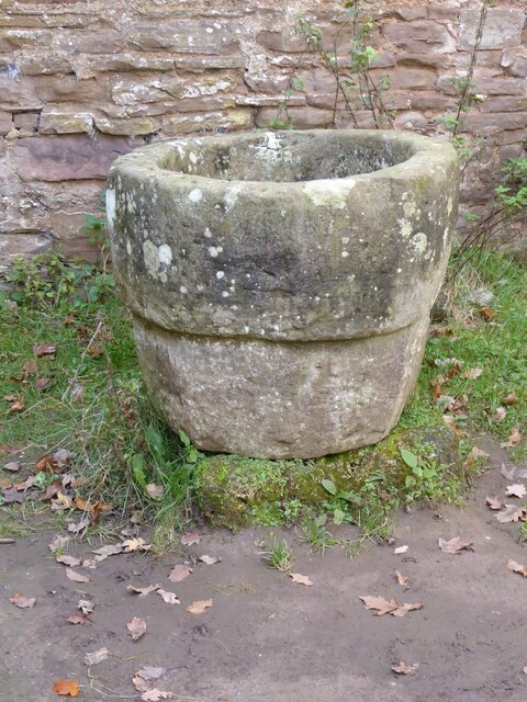
In addition to its natural beauty, Bringsty Common holds historical significance. It is believed to have been a site of ancient settlements, with remnants of Iron Age hillforts and burial mounds scattered throughout the area. These historical features add a sense of mystery and intrigue to the common, making it an intriguing destination for history enthusiasts.

Overall, Bringsty Common offers a tranquil escape from the hustle and bustle of everyday life. With its stunning landscapes, diverse wildlife, and historical allure, it is a place that truly showcases the beauty and charm of Herefordshire's countryside.

If you have any feedback on the listing, please let us know in the comments section below.

Bringsty Common Images

Images are sourced within 2km of 52.191767/-2.4408207 or Grid Reference SO6954. Thanks to Geograph Open Source API. All images are credited.

Drive into Brockhampton Autumn trees providing a welcoming splash of seasonal colour on the drive into Brockhampton estate.
Drive into Brockhampton
Autumn trees providing a welcoming splash of seasonal colour on the drive into Brockhampton estate.
The entrance to Brockhampton estate The entrance to Brockhampton estate from the A44.  The lodge can be seen on the right.
The entrance to Brockhampton estate
The entrance to Brockhampton estate from the A44. The lodge can be seen on the right.
Brockhampton House Brockhampton House was built for Bartholomew Barnby in the 1760s; the architect is likely to be Thomas Farnolls Pritchard, who was also involved in the design of the world's first iron bridge spanning the River Severn at Ironbridge. The house is Grade II* listed, see: <span class="nowrap"><a title="https://historicengland.org.uk/listing/the-list/list-entry/1176659" rel="nofollow ugc noopener" href="https://historicengland.org.uk/listing/the-list/list-entry/1176659">Link</a><img style="margin-left:2px;" alt="External link" title="External link - shift click to open in new window" src="https://s1.geograph.org.uk/img/external.png" width="10" height="10"/></span>
Brockhampton House
Brockhampton House was built for Bartholomew Barnby in the 1760s; the architect is likely to be Thomas Farnolls Pritchard, who was also involved in the design of the world's first iron bridge spanning the River Severn at Ironbridge. The house is Grade II* listed, see: LinkExternal link
A tree stump at Brockhampton I photographed this same tree stump back in August, on that occasion it had an occupant <a href="https://www.geograph.org.uk/photo/6937602">SO6854 : Ewe in hollow tree stump</a>.
A tree stump at Brockhampton
I photographed this same tree stump back in August, on that occasion it had an occupant SO6854 : Ewe in hollow tree stump.
View to the stables at Brockhampton View to the stables to Brockhampton House.
View to the stables at Brockhampton
View to the stables to Brockhampton House.
Brockhampton Park View to Brockhampton House from the parkland.
Brockhampton Park
View to Brockhampton House from the parkland.
Lawn Pool, Brockhampton Park View across parkland to Brockhampton House from Lawn Pool.
Lawn Pool, Brockhampton Park
View across parkland to Brockhampton House from Lawn Pool.
Lawn Pool dam Trees have recently been felled here opening up the woodland below the dam.
Lawn Pool dam
Trees have recently been felled here opening up the woodland below the dam.
Shaggy inkcap Shaggy inkcap (Coprinus comatus) in Brockhampton Park.
Shaggy inkcap
Shaggy inkcap (Coprinus comatus) in Brockhampton Park.
Track at Lower Brockhampton Track to farm buildings at Lower Brockhampton.
Track at Lower Brockhampton
Track to farm buildings at Lower Brockhampton.
Lower Brockhampton Lower Brockhampton is a moated half-timbered manor house dating from the late 14th century, complete with a timber-framed gatehouse straddling the moat. The Brockhampton Estate was bequeathed to the National Trust in 1946 by Colonel John Talbot Lutley. The house is Grade I listed.
Lower Brockhampton
Lower Brockhampton is a moated half-timbered manor house dating from the late 14th century, complete with a timber-framed gatehouse straddling the moat. The Brockhampton Estate was bequeathed to the National Trust in 1946 by Colonel John Talbot Lutley. The house is Grade I listed.
Rowan berries Rowan berries at Lower Brockhampton.
Rowan berries
Rowan berries at Lower Brockhampton.
Font at Lower Brockhampton Font in the abandoned church at Lower Brockhampton.
Font at Lower Brockhampton
Font in the abandoned church at Lower Brockhampton.
Brockhampton medieval manor house Compiled by Brian Robert Marshall

The Brockhampton Estate centred on Lower Brockhampton is a National Trust property and has been since 1946 when it was bequeathed to the Trust by the last owner Colonel John Lutley. It was and remains a working farm and the ancient buildings were occupied as late as the 1980s. The two main buildings are the farmhouse and the gatehouse which date to the 14th and 16th centuries respectively. In 2010 the farmhouse was comprehensively restored following earlier restoration and repair programmes in 1871, 1947 and the 1990s <span class="nowrap"><a title="http://www.malverngazette.co.uk/news/8289513.Historic_building_repair_project_is_completed/" rel="nofollow ugc noopener" href="http://www.malverngazette.co.uk/news/8289513.Historic_building_repair_project_is_completed/">Link</a><img style="margin-left:2px;" alt="External link" title="External link - shift click to open in new window" src="https://s1.geograph.org.uk/img/external.png" width="10" height="10"/></span> 

The gatehouse has also recently been restored.

The third building of interest is the ruin of a Norman chapel used for storage purposes from the late 18th century until the 1980s.

The farmhouse is listed Grade I <span class="nowrap"><a title="http://www.imagesofengland.org.uk/Details/default.aspx?pid=2&id=150962" rel="nofollow ugc noopener" href="http://www.imagesofengland.org.uk/Details/default.aspx?pid=2&id=150962">Link</a><img style="margin-left:2px;" alt="External link" title="External link - shift click to open in new window" src="https://s1.geograph.org.uk/img/external.png" width="10" height="10"/></span> as is the gatehouse <span class="nowrap"><a title="http://www.imagesofengland.org.uk/Details/default.aspx?pid=2&id=150963" rel="nofollow ugc noopener" href="http://www.imagesofengland.org.uk/Details/default.aspx?pid=2&id=150963">Link</a><img style="margin-left:2px;" alt="External link" title="External link - shift click to open in new window" src="https://s1.geograph.org.uk/img/external.png" width="10" height="10"/></span>

The chapel is Grade II* <span class="nowrap"><a title="http://www.imagesofengland.org.uk/Details/default.aspx?pid=2&id=150964" rel="nofollow ugc noopener" href="http://www.imagesofengland.org.uk/Details/default.aspx?pid=2&id=150964">Link</a><img style="margin-left:2px;" alt="External link" title="External link - shift click to open in new window" src="https://s1.geograph.org.uk/img/external.png" width="10" height="10"/></span>
Brockhampton medieval manor house
Compiled by Brian Robert Marshall The Brockhampton Estate centred on Lower Brockhampton is a National Trust property and has been since 1946 when it was bequeathed to the Trust by the last owner Colonel John Lutley. It was and remains a working farm and the ancient buildings were occupied as late as the 1980s. The two main buildings are the farmhouse and the gatehouse which date to the 14th and 16th centuries respectively. In 2010 the farmhouse was comprehensively restored following earlier restoration and repair programmes in 1871, 1947 and the 1990s LinkExternal link The gatehouse has also recently been restored. The third building of interest is the ruin of a Norman chapel used for storage purposes from the late 18th century until the 1980s. The farmhouse is listed Grade I LinkExternal link as is the gatehouse LinkExternal link The chapel is Grade II* LinkExternal link
Damson orchard, Brockhampton
View to the orchard at Brockhampton Looking through a window in the C15 half-timbered gatehouse of Lower Brockhampton, towards the moat and orchard of damson trees in full blossom.
View to the orchard at Brockhampton
Looking through a window in the C15 half-timbered gatehouse of Lower Brockhampton, towards the moat and orchard of damson trees in full blossom.
Brockhampton Chapel The new Brockhampton Chapel was built in 1798 replacing an earlier Norman chapel which is situated beside Lower Brockhampton House. The design is thought to be by George Byfield, however, it is now thought John Nash may have had some involvement. The chapel is in the care of the National Trust and is occasionally open to the public.  The chapel is Grade II* listed. See: <span class="nowrap"><a title="https://historicengland.org.uk/listing/the-list/list-entry/1349630" rel="nofollow ugc noopener" href="https://historicengland.org.uk/listing/the-list/list-entry/1349630">Link</a><img style="margin-left:2px;" alt="External link" title="External link - shift click to open in new window" src="https://s1.geograph.org.uk/img/external.png" width="10" height="10"/></span>
Brockhampton Chapel
The new Brockhampton Chapel was built in 1798 replacing an earlier Norman chapel which is situated beside Lower Brockhampton House. The design is thought to be by George Byfield, however, it is now thought John Nash may have had some involvement. The chapel is in the care of the National Trust and is occasionally open to the public. The chapel is Grade II* listed. See: LinkExternal link
Show me another place!

Bringsty Common is located at Grid Ref: SO6954 (Lat: 52.191767, Lng: -2.4408207)

Unitary Authority: County of Herefordshire

Police Authority: West Mercia

What 3 Words

///galleries.poets.resembles. Near Bromyard, Herefordshire

Related Wikis

Bringsty Common

Bringsty Common is a scattered settlement and 220 acres (89 ha) of common land in Herefordshire, England, spanning the A44. It lies close to the Worcestershire...

Brockhampton (near Bromyard)

Brockhampton is a civil parish in Herefordshire, England, about 4 km (2 mi) east of Bromyard. The parish comprises the National Trust property of Brockhampton...

Linton (near Bromyard)

Linton is a civil parish in north-east of Herefordshire, England, and is approximately 14 miles (23 km) north-east from the city and county town of Hereford...
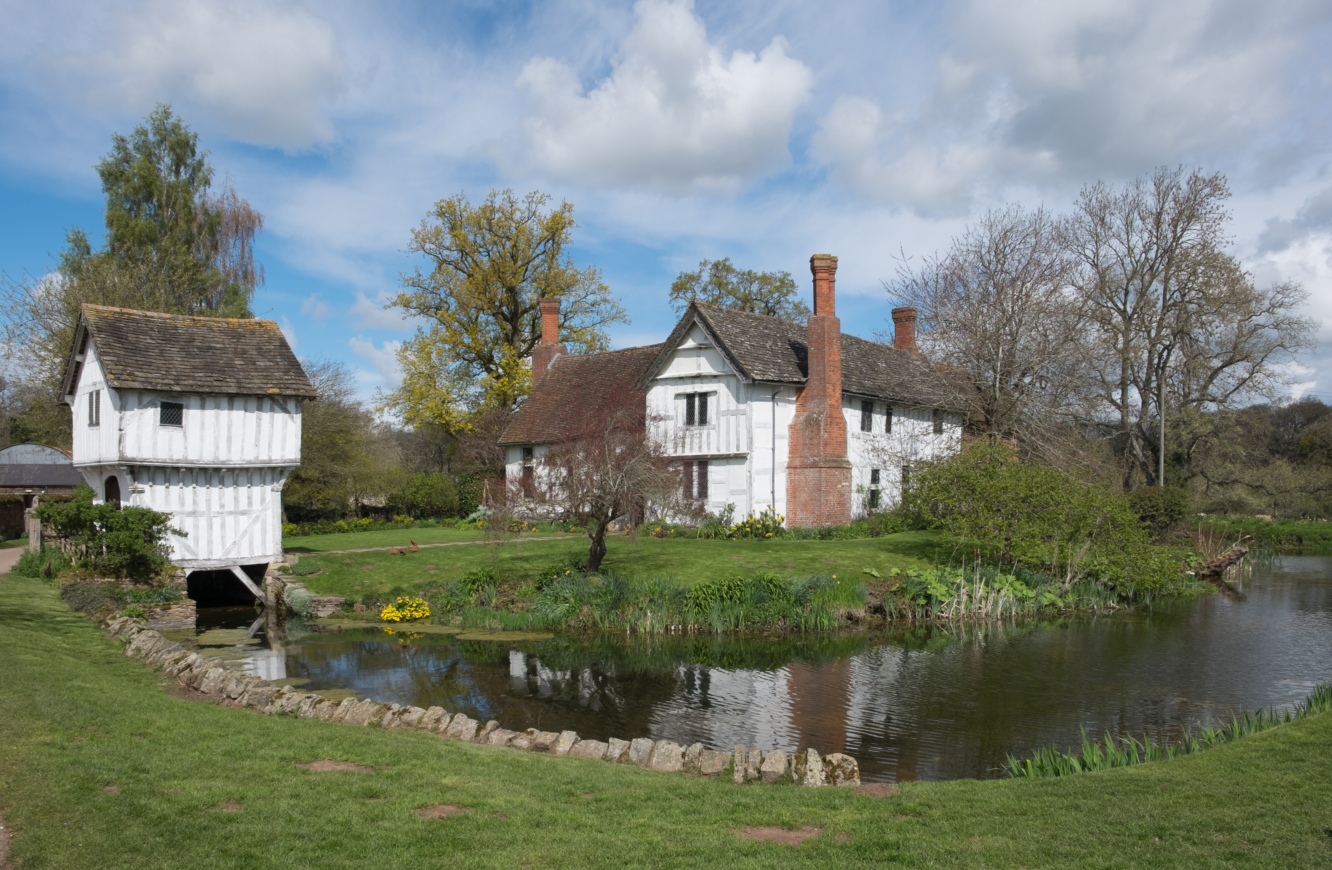
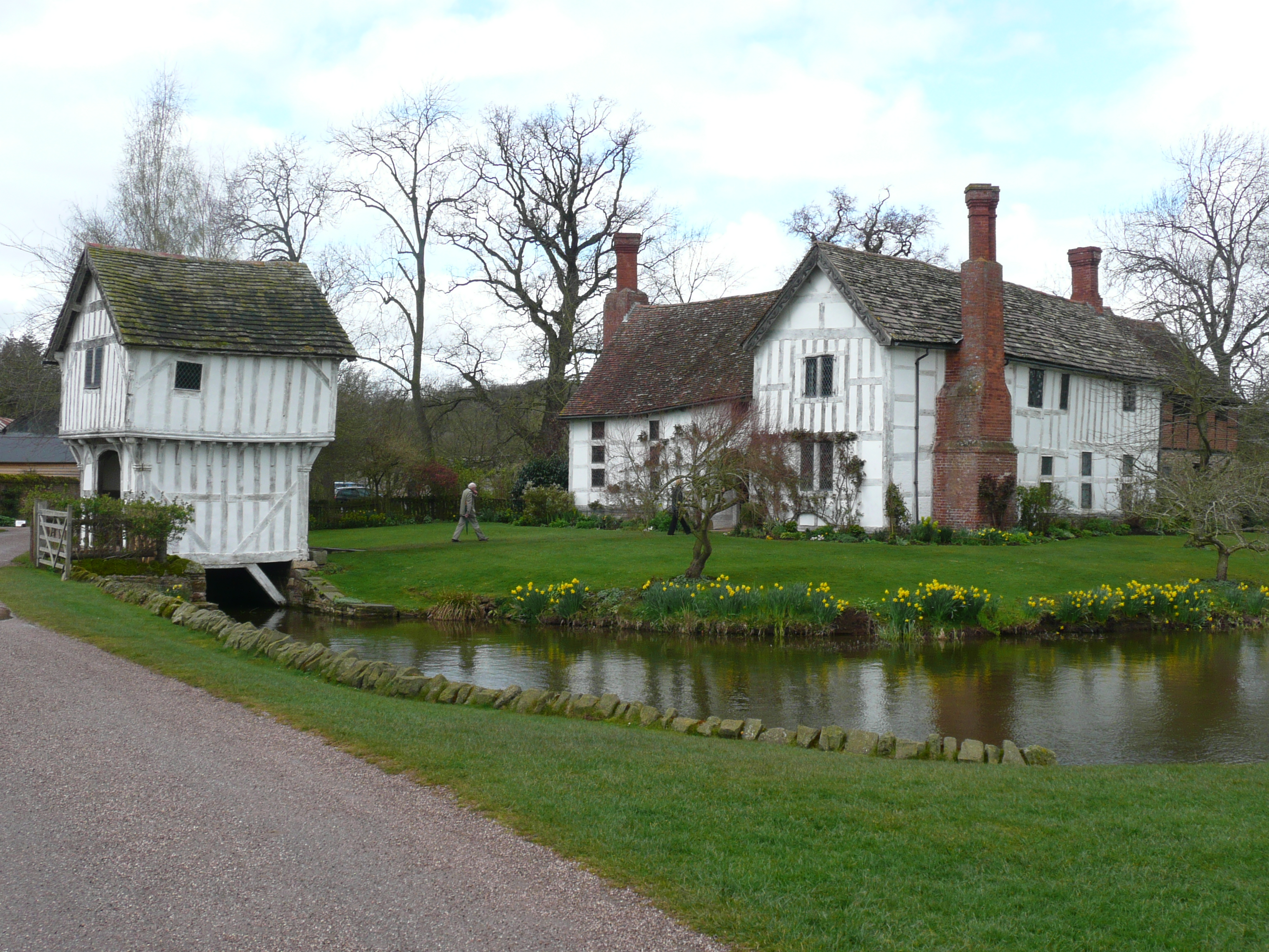
Brockhampton Estate

The Brockhampton Estate is a National Trust property in Herefordshire, England, and is to the north of the A44 Bromyard to Worcester road, opposite the...

Nearby Amenities

Located within 500m of 52.191767,-2.4408207
Bringsty
Ele: 152
Natural: peak
Lat/Long: 52.1914419/-2.443609
Toposcope
Tourism: viewpoint
Lat/Long: 52.1910793/-2.4448193
Bench
Backrest: no
Lat/Long: 52.1908902/-2.4448086
Bench
Backrest: yes
Lat/Long: 52.1911155/-2.4444653
Information: map
Tourism: information
Lat/Long: 52.1931017/-2.4424348
Power: pole
Source: estimate
Lat/Long: 52.1946692/-2.4454317
Sandygate
Power: pole
Source: bing
Transformer: distribution
Voltage Primary: 11000
Lat/Long: 52.1893567/-2.4460446
Power: pole
Source: bing
Lat/Long: 52.1897981/-2.4461934
Power: pole
Source: bing
Lat/Long: 52.1902314/-2.4468345
Power: pole
Source: bing
Lat/Long: 52.1906778/-2.4475922
Power: pole
Source: bing
Lat/Long: 52.1909812/-2.4479644
Power: pole
Source: bing
Lat/Long: 52.1939424/-2.4471724
Power: pole
Source: bing
Lat/Long: 52.1943453/-2.4462175
Power: pole
Source: bing
Lat/Long: 52.1950407/-2.4445559
Power: pole
Source: bing
Lat/Long: 52.195243/-2.4440785
Power: pole
Source: bing
Lat/Long: 52.1955948/-2.4432242
Power: pole
Source: bing
Lat/Long: 52.1958414/-2.4426395
Rose Cottage
Power: pole
Source: bing
Transformer: distribution
Voltage Primary: 11000
Lat/Long: 52.1959877/-2.4422586
The Oaks
Power: pole
Source: bing
Transformer: distribution
Voltage Primary: 11000
Lat/Long: 52.1960716/-2.4394584
Power: pole
Source: bing
Lat/Long: 52.1885575/-2.4377632
Power: pole
Source: bing
Lat/Long: 52.1891116/-2.4381495
Power: pole
Source: bing
Lat/Long: 52.1895375/-2.438482
Power: pole
Source: bing
Lat/Long: 52.1899362/-2.4387905
Power: pole
Source: bing
Lat/Long: 52.1904682/-2.4391714
Live & Let Live
Power: pole
Source: bing
Transformer: distribution
Voltage Primary: 11000
Lat/Long: 52.1908661/-2.4394718
Power: pole
Source: bing
Lat/Long: 52.1913956/-2.439563
Power: pole
Source: bing
Lat/Long: 52.1917737/-2.4396488
Power: pole
Source: bing
Transformer: distribution
Voltage Primary: 11000
Lat/Long: 52.1924479/-2.4397722
Power: pole
Source: bing
Lat/Long: 52.1917121/-2.4351333
Power: pole
Source: bing
Lat/Long: 52.1922654/-2.4339853
Man Made: survey_point
Lat/Long: 52.1914424/-2.4435648
Sunnyside Bringsty
Power: pole
Transformer: distribution
Voltage Primary: 11000
Lat/Long: 52.1881908/-2.437503
Power: pole
Lat/Long: 52.1905315/-2.4377377
Lower Craddocks
Power: pole
Transformer: distribution
Voltage Primary: 11000
Lat/Long: 52.1905989/-2.435836
Power: pole
Lat/Long: 52.1911596/-2.4363671
Power: pole
Lat/Long: 52.1940933/-2.4468277
The data included in this document is from www.openstreetmap.org. The data is made available under ODbL.

Have you been to Bringsty Common?

Leave your review of Bringsty Common below (or comments, questions and feedback).