Melmerby Fell

Downs, Moorland in Cumberland Eden

England

Melmerby Fell

Summit cairn on Melmerby Fell
Summit cairn on Melmerby Fell Credit: Colin Park

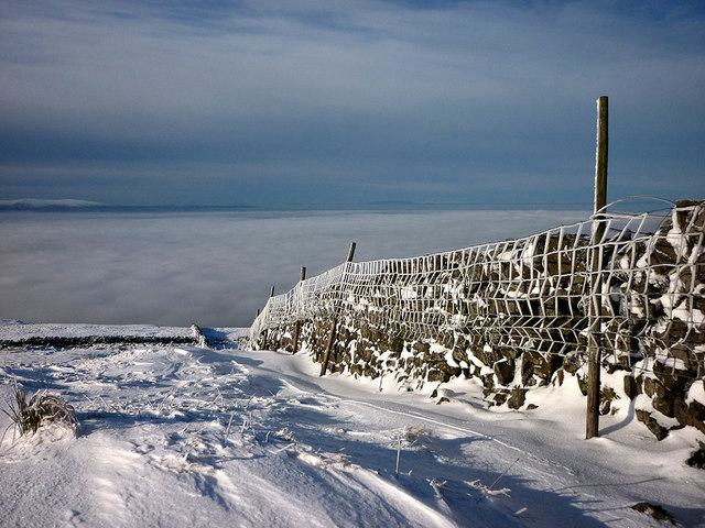
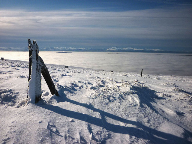
Melmerby Fell is a stunning area of natural beauty located in the historic county of Cumberland, England. Situated in the northwestern part of the country, it is part of the picturesque Pennines range. Melmerby Fell encompasses a vast expanse of downs and moorland, offering visitors a unique and diverse landscape to explore.

With its rolling hills and expansive open spaces, Melmerby Fell is a haven for outdoor enthusiasts and nature lovers. The area is known for its rich biodiversity, with a variety of plant and animal species calling it home. Visitors can expect to see an array of wildflowers, including heather and bilberry, painting the landscape with vibrant colors.

The fell is also home to a number of wildlife species, such as red grouse, curlews, and golden plovers. Birdwatchers will find themselves in awe of the avian diversity that can be spotted in the area. The moorland provides the perfect habitat for these creatures, making it a popular destination for birdwatching enthusiasts.

Aside from its natural beauty, Melmerby Fell offers a range of recreational activities for visitors to enjoy. Hiking and walking trails crisscross the area, providing opportunities to explore its scenic vistas and enjoy panoramic views of the surrounding countryside. On a clear day, one can even catch a glimpse of the famous Lake District National Park, which lies to the west.

For those seeking a peaceful retreat in the heart of the English countryside, Melmerby Fell is a must-visit destination. Its natural charm, diverse wildlife, and outdoor activities make it a haven for nature enthusiasts and a place that truly captures the essence of Cumberland's beauty.

If you have any feedback on the listing, please let us know in the comments section below.

Melmerby Fell Images

Images are sourced within 2km of 54.746503/-2.5373381 or Grid Reference NY6539. Thanks to Geograph Open Source API. All images are credited.

Summit cairn on Melmerby Fell
Upright stone, Maiden Way on Melmerby Fell We saw no markings on the stone but its location near the old bridleway (and Roman Road) suggests it was a marker for the route in poor weather. No need today with Cross Fell in clear view across the moorland miles.
Upright stone, Maiden Way on Melmerby Fell
We saw no markings on the stone but its location near the old bridleway (and Roman Road) suggests it was a marker for the route in poor weather. No need today with Cross Fell in clear view across the moorland miles.
Small tarn near the Maiden Way on Melmerby Fell The upright slab of gritstone may be a marker (similar to <a title="https://www.geograph.org.uk/photo/2770101)" href="https://www.geograph.org.uk/photo/2770101)">Link</a> - but if so, why is it here and not by the track?
Small tarn near the Maiden Way on Melmerby Fell
The upright slab of gritstone may be a marker (similar to Link - but if so, why is it here and not by the track?
Crossing Melmerby Fell on a fine frosty afternoon Firm, easy going - where else would you wish to be? Looking towards Cross Fell which looks a lot closer than it actually is.
Crossing Melmerby Fell on a fine frosty afternoon
Firm, easy going - where else would you wish to be? Looking towards Cross Fell which looks a lot closer than it actually is.
Summit cairn, Melmerby Fell Looking from the 709m top (Dun Edge) towards the large cairn on Knapside Hill. It was from here that we began to see deeply rutted trail bike tracks which took the edge of what was a superb day on the North Pennine fells.
Summit cairn, Melmerby Fell
Looking from the 709m top (Dun Edge) towards the large cairn on Knapside Hill. It was from here that we began to see deeply rutted trail bike tracks which took the edge of what was a superb day on the North Pennine fells.
Heading for Knapside Hill An easy track leads across from Melmerby Fell.
Heading for Knapside Hill
An easy track leads across from Melmerby Fell.
Trail bike damage on Knapside Hill These ruts were apparent much of the way from the footpath entry onto the open fell <a title="https://www.geograph.org.uk/photo/2771008" href="https://www.geograph.org.uk/photo/2771008">Link</a> right across to Melmerby Fell. The people who ride these bikes (illegally) on public footpaths and over fragile ground could not care less about the environment. I have reported the problem to the North Pennines AONB unit so at least they are aware of the situation.
Trail bike damage on Knapside Hill
These ruts were apparent much of the way from the footpath entry onto the open fell Link right across to Melmerby Fell. The people who ride these bikes (illegally) on public footpaths and over fragile ground could not care less about the environment. I have reported the problem to the North Pennines AONB unit so at least they are aware of the situation.
Ruined sheepfold on west flank of Knapside Hill Looking towards a distant Cross Fell.
Ruined sheepfold on west flank of Knapside Hill
Looking towards a distant Cross Fell.
Cairn above Blea Scar This large cairn is in prominent view on the descent from Knapside Hill. Across the hazy Eden Valley rise the northern fells of the Lake District.
Cairn above Blea Scar
This large cairn is in prominent view on the descent from Knapside Hill. Across the hazy Eden Valley rise the northern fells of the Lake District.
Trail bike damage below Knapside Hill These ruts were apparent much of the way from the footpath entry onto the open fell right across to Melmerby Fell <a title="https://www.geograph.org.uk/photo/2770490" href="https://www.geograph.org.uk/photo/2770490">Link</a> The people who ride these bikes (illegally) on public footpaths and over fragile ground could not care less about the environment. I have reported the problem to the North Pennines AONB unit so at least they are aware of the situation.
Trail bike damage below Knapside Hill
These ruts were apparent much of the way from the footpath entry onto the open fell right across to Melmerby Fell Link The people who ride these bikes (illegally) on public footpaths and over fragile ground could not care less about the environment. I have reported the problem to the North Pennines AONB unit so at least they are aware of the situation.
Shakeholes below Little Knapside Hill The soft snow made for heavy going weaving around these big depressions that indicate a band of limestone below the peat and boulder clay. The fantastic cloud inversion in the Eden Valley did make a great excuse to stop and admire the view.
Shakeholes below Little Knapside Hill
The soft snow made for heavy going weaving around these big depressions that indicate a band of limestone below the peat and boulder clay. The fantastic cloud inversion in the Eden Valley did make a great excuse to stop and admire the view.
Wall and fence, Little Knapside Hill At this point the drystone wall ends, leaving just a post and wire fence (except for a very short stretch higher up) continuing to the top of the fell and beyond.
Wall and fence, Little Knapside Hill
At this point the drystone wall ends, leaving just a post and wire fence (except for a very short stretch higher up) continuing to the top of the fell and beyond.
The fence on Tod Raise Heading for Little Knapside Hill in soft snow but with great views over the cloud inversion to the Lakeland fells.
The fence on Tod Raise
Heading for Little Knapside Hill in soft snow but with great views over the cloud inversion to the Lakeland fells.
Short stretch of wall on Tod Raise On the long stretch towards the top of the hill the fence crosses a patch of rocks and reverts to drystone wall for a short section. Across the Eden Valley are the Lake District mountains rising out of a cloud inversion
Short stretch of wall on Tod Raise
On the long stretch towards the top of the hill the fence crosses a patch of rocks and reverts to drystone wall for a short section. Across the Eden Valley are the Lake District mountains rising out of a cloud inversion
Old fenceposts, Little Knapside Hill Passed en route to Fiends Fell. Beyond, a line of wooden shooting butts head down the slope. No grouse in evidence today up here above the cloud inversion that fills the Eden Valley. Rising out of this are the snow-covered fells of the Lake District.
Old fenceposts, Little Knapside Hill
Passed en route to Fiends Fell. Beyond, a line of wooden shooting butts head down the slope. No grouse in evidence today up here above the cloud inversion that fills the Eden Valley. Rising out of this are the snow-covered fells of the Lake District.
Fence, west flank of Little Knapside Hill At the crest of the steepest part of the slope, a small cornice of windblown snow has formed. Luckily, we managed to hack our way through and succeeded in conquering this formidable peak.
Fence, west flank of Little Knapside Hill
At the crest of the steepest part of the slope, a small cornice of windblown snow has formed. Luckily, we managed to hack our way through and succeeded in conquering this formidable peak.
The summit of Little Knapside Hill (657m) A wilderness of snow in the North Pennines. On the skyline the cairn <a title="https://www.geograph.org.uk/photo/1927051" href="https://www.geograph.org.uk/photo/1927051">Link</a> on Knapside Hill is just visible on the extreme right. Leftwards are Melmerby Fell and the dominant height of Cross Fell (a lot further away than it looks). We like to walk on untrodden ground but today we were grateful that others had broken trail in the soft snow as we made our way north to Fiend's Fell.
The summit of Little Knapside Hill (657m)
A wilderness of snow in the North Pennines. On the skyline the cairn Link on Knapside Hill is just visible on the extreme right. Leftwards are Melmerby Fell and the dominant height of Cross Fell (a lot further away than it looks). We like to walk on untrodden ground but today we were grateful that others had broken trail in the soft snow as we made our way north to Fiend's Fell.
The summit of Little Knapside Hill (657m) Looking across to Blencathra and the northern fells of the Lake District.
The summit of Little Knapside Hill (657m)
Looking across to Blencathra and the northern fells of the Lake District.
Show me another place!

Melmerby Fell is located at Grid Ref: NY6539 (Lat: 54.746503, Lng: -2.5373381)

Administrative County: Cumbria

District: Eden

Police Authority: Cumbria

What 3 Words

///afterglow.sunbeam.snipped. Near Alston, Cumbria

Nearby Locations

Melmerby Fell

Related Wikis

Melmerby, Cumbria

Melmerby is a village and civil parish in the Eden district, in the county of Cumbria, England. It is a small village with a population of around 200....

St John's Church, Gamblesby

St. John's Church was a Victorian parish Church of England church in the village of Gamblesby, Cumbria, England.The Gothic Revival-style church, with tall...

Gamblesby

Gamblesby is a village near Melmerby, and former civil parish, now in the parish of Glassonby, in the Westmorland and Furness district, in the ceremonial...

Unthank, Glassonby

Unthank is a village near Gamblesby in the civil parish of Glassonby in Cumbria, England. It is first mentioned in writing as Unthanke in 1332. == See... ==

Nearby Amenities

Located within 500m of 54.746503,-2.5373381
Abandoned: yes
Historic: mine_shaft
Lat/Long: 54.7420111/-2.5375697
Abandoned: yes
Historic: mine_shaft
Lat/Long: 54.7423333/-2.5386016
The data included in this document is from www.openstreetmap.org. The data is made available under ODbL.

Have you been to Melmerby Fell?

Leave your review of Melmerby Fell below (or comments, questions and feedback).