Brae of Fawnyard

Downs, Moorland in Kincardineshire

Scotland

Brae of Fawnyard

Waird of Kettock Heather covered hillside.
Waird of Kettock Credit: Nigel Corby

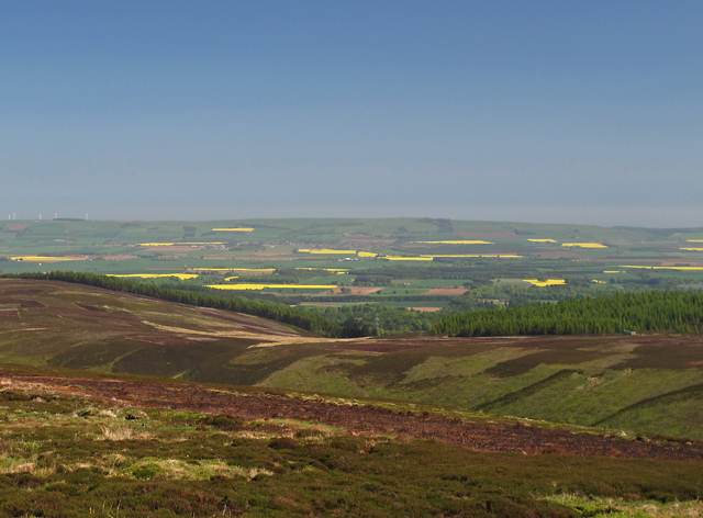
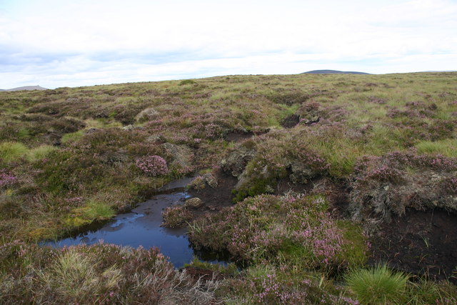
Brae of Fawnyard is a captivating area located in Kincardineshire, Scotland. Situated in the Downs and Moorland region, it boasts a stunning landscape that combines rolling hills, heather-covered moorland, and picturesque valleys. Spanning approximately 200 acres, Brae of Fawnyard attracts nature enthusiasts, hikers, and photographers alike.

The area is characterized by its diverse flora and fauna. Visitors can witness a variety of wildflowers, including purple heather, yellow gorse, and vibrant foxgloves, adding a burst of color to the landscape. The moorland is also home to a range of bird species, such as curlews, lapwings, and red grouse, offering birdwatchers ample opportunities to observe and document these fascinating creatures.

Moreover, the rolling hills of Brae of Fawnyard provide breathtaking panoramic views of the surrounding countryside. On clear days, visitors can marvel at the distant peaks of the Cairngorms and Grampian Mountains, creating a truly awe-inspiring sight. The area is also intersected by a tranquil stream, which cascades down the hills, adding to the serene ambiance.

In addition to its natural beauty, Brae of Fawnyard holds historical significance. Ruins of ancient settlements and burial cairns can be found scattered throughout the area, serving as a reminder of its rich cultural heritage.

Overall, Brae of Fawnyard in Kincardineshire offers a captivating blend of natural wonders and historical landmarks, making it a must-visit destination for those seeking a peaceful retreat amidst Scotland's stunning countryside.

If you have any feedback on the listing, please let us know in the comments section below.

Brae of Fawnyard Images

Images are sourced within 2km of 56.908357/-2.6387007 or Grid Reference NO6179. Thanks to Geograph Open Source API. All images are credited.

Waird of Kettock Heather covered hillside.
Waird of Kettock
Heather covered hillside.
No room at the  inn An old stable block adjacent to the Water of Charr. Very wet inside on the day of my visit but would provide shelter if the need arose. The path shown leads to the summit of Meluncart.
No room at the inn
An old stable block adjacent to the Water of Charr. Very wet inside on the day of my visit but would provide shelter if the need arose. The path shown leads to the summit of Meluncart.
Tussocks below Rough Bank Rough moorland south of Glen Dye with a view towards Mount Battock.
Tussocks below Rough Bank
Rough moorland south of Glen Dye with a view towards Mount Battock.
View towards Mount Battock Miles of moorland, but probable that there will be wind turbines here by the time you read this.
View towards Mount Battock
Miles of moorland, but probable that there will be wind turbines here by the time you read this.
White Shank Hills covered in deep peat, much of which will soon be carbon dioxide after the bog is dug up for wind turbines.
White Shank
Hills covered in deep peat, much of which will soon be carbon dioxide after the bog is dug up for wind turbines.
East of the Hill of Remora Boggy ground to the east of the Hill of Remora. The upper course of the Short Gormack Burn can be seen in the middle distance, and further away the summit of Clachnaben.
East of the Hill of Remora
Boggy ground to the east of the Hill of Remora. The upper course of the Short Gormack Burn can be seen in the middle distance, and further away the summit of Clachnaben.
Above the Shank of Cardowan A view from the hillside above the Shank of Cardowan, with cultivated fields in the Howe of the Mearns visible in the distance.
Above the Shank of Cardowan
A view from the hillside above the Shank of Cardowan, with cultivated fields in the Howe of the Mearns visible in the distance.
View from Hound Hillock A view to the east from the summit of Hound Hillock. This image was taken on an unusually hot day, with extensive haze limiting visibility. Farm-fields in the Howe of the Mearns can be seen in the distance - beyond these lies the North Sea.
View from Hound Hillock
A view to the east from the summit of Hound Hillock. This image was taken on an unusually hot day, with extensive haze limiting visibility. Farm-fields in the Howe of the Mearns can be seen in the distance - beyond these lies the North Sea.
Cross at your peril! This footbridge over the Water of Charr has had its day and would not look out of place on the set of an Indianan Jones film. The landrover track next to the Water of Charr has now been extended to a roofless ruin shown on the OS maps at ref. 605 796
Cross at your peril!
This footbridge over the Water of Charr has had its day and would not look out of place on the set of an Indianan Jones film. The landrover track next to the Water of Charr has now been extended to a roofless ruin shown on the OS maps at ref. 605 796
Water of Charr Beneath the moorland slopes named as Brae of Fawnyard.
Water of Charr
Beneath the moorland slopes named as Brae of Fawnyard.
Fence, Water of Charr Unusually, there are some vicious looking spikes of stiff wire on the fence posts.
Fence, Water of Charr
Unusually, there are some vicious looking spikes of stiff wire on the fence posts.
Headwaters of the Charr Peat clothed hills draining into the Water of Charr.
Headwaters of the Charr
Peat clothed hills draining into the Water of Charr.
All terrain vehicle track, Water of Charr Moorland path amongst the Charr headwaters.
All terrain vehicle track, Water of Charr
Moorland path amongst the Charr headwaters.
Towards Cock Hill
Towards Cock Hill
View towards Meluncart Moorland south of Glen Dye, Kincardineshire.
View towards Meluncart
Moorland south of Glen Dye, Kincardineshire.
Road, Water of Charr Side glen off Glen Dye.
Road, Water of Charr
Side glen off Glen Dye.
Tough's Market What or where Tough's Market was is unsure, but old 6" place it on the haughs either side of the Water of Charr.  It was customary to hold markets on or near watersheds so that everyone only had one hill to climb, a famous example being the fair on An Sgarsoch, Mar/Atholl.
Tough's Market
What or where Tough's Market was is unsure, but old 6" place it on the haughs either side of the Water of Charr. It was customary to hold markets on or near watersheds so that everyone only had one hill to climb, a famous example being the fair on An Sgarsoch, Mar/Atholl.
Rough Bank Targeted by wind farmers so this could be one of the last photographs.  Taken from the road up Water of Charr prior to an ascent.
Rough Bank
Targeted by wind farmers so this could be one of the last photographs. Taken from the road up Water of Charr prior to an ascent.
Show me another place!

Brae of Fawnyard is located at Grid Ref: NO6179 (Lat: 56.908357, Lng: -2.6387007)

Unitary Authority: Aberdeenshire

Police Authority: North East

What 3 Words

///lightbulb.gratitude.buddy. Near Laurencekirk, Aberdeenshire

Nearby Locations

Brae of Fawnyard

Related Wikis

Cairn O' Mounth

Cairn O' Mounth/Cairn O' Mount (Scottish Gaelic: Càrn Mhon) is a high mountain pass in Aberdeenshire, Scotland. The place name is a survival of the ancient...

Colmeallie stone circle

The Colmeallie stone circle is a recumbent stone circle in Glen Esk, Angus, Scotland. It is located 8 km north of Edzell at Colmeallie Farm, adjacent to...

Fasque House

Fasque, also known as Fasque House or Fasque Castle, is a mansion in Aberdeenshire, Scotland, situated near the village of Fettercairn, in the former county...

Clachnaben

Clachnaben (archaically "Cloch-na'bain"; Scottish Gaelic: "Clach na Beinne") is a 589-metre hill in Glen Dye, Aberdeenshire, Scotland. It is a distinctive...

Fettercairn distillery

Fettercairn distillery is a whisky distillery in Fettercairn. Situated under the Grampian foothills in the Howe of Mearns, Fettercairn town’s name is...

Millden

Millden is a hamlet, estate and farmstead in Glenesk, Angus, Scotland. It is situated in the upper course of the Glen Esk valley, where the Burn of Turret...

Fettercairn

Fettercairn (, Scottish Gaelic: Fothair Chàrdain) is a small village in Aberdeenshire, Scotland, northwest of Laurencekirk in Aberdeenshire on the B966...

Kincardine, Aberdeenshire

Kincardine was a burgh in Scotland, near the present-day village of Fettercairn. It served as the first county town of Kincardineshire. The settlement...

Nearby Amenities

Located within 500m of 56.908357,-2.6387007
Ford: yes
Lat/Long: 56.9103895/-2.6372472
The data included in this document is from www.openstreetmap.org. The data is made available under ODbL.

Have you been to Brae of Fawnyard?

Leave your review of Brae of Fawnyard below (or comments, questions and feedback).