Boddomend Wood

Downs, Moorland in Aberdeenshire

Scotland

Boddomend Wood

Eastern suburb of Aboyne
Eastern suburb of Aboyne Credit: Alan Reid

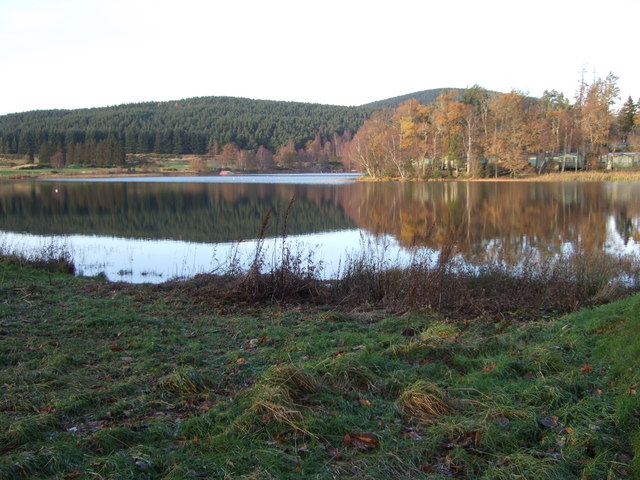
Boddomend Wood is a picturesque area located in Aberdeenshire, Scotland. Covering a vast expanse of downs and moorland, the wood is known for its rich biodiversity and stunning natural beauty. The wood is home to a variety of plant and animal species, including native trees such as oak, birch, and pine, as well as a diverse range of birdlife and wildlife.

Visitors to Boddomend Wood can enjoy leisurely walks and hikes through the peaceful surroundings, taking in the fresh air and tranquility of the area. The wood offers panoramic views of the surrounding countryside, making it a popular spot for nature enthusiasts and photographers.

In addition to its natural beauty, Boddomend Wood also holds historical significance, with remnants of ancient settlements and archaeological sites scattered throughout the area. Visitors can explore these historical landmarks and learn about the rich history of the region.

Overall, Boddomend Wood is a hidden gem in Aberdeenshire, offering a peaceful retreat for those looking to connect with nature and explore the beauty of the Scottish countryside.

If you have any feedback on the listing, please let us know in the comments section below.

Boddomend Wood Images

Images are sourced within 2km of 57.086136/-2.7359674 or Grid Reference NO5599. Thanks to Geograph Open Source API. All images are credited.

Eastern suburb of Aboyne
Bell Wood Open conifer forest on the edge of Aboyne.
Bell Wood
Open conifer forest on the edge of Aboyne.
Track on the north edge of Bell Wood Formerly continued straight through to Newton of Drumgesk.
Track on the north edge of Bell Wood
Formerly continued straight through to Newton of Drumgesk.
A93 towards Banchory
Bell Wood picnic spot Geocaching is a type of global treasure hunt of people looking for caches, or hidden stashes of objects. Geocaching may also be described as a series of hide-and-seek games, where hiders provide online clues for seekers. Seekers use global positioning system (GPS) devices to find hidden caches
Bell Wood picnic spot
Geocaching is a type of global treasure hunt of people looking for caches, or hidden stashes of objects. Geocaching may also be described as a series of hide-and-seek games, where hiders provide online clues for seekers. Seekers use global positioning system (GPS) devices to find hidden caches
Bell Wood bike park
Bell Wood bike park
Digger's shelter Geocaching is a type of global treasure hunt of people looking for caches, or hidden stashes of objects. Geocaching may also be described as a series of hide-and-seek games, where hiders provide online clues for seekers. Seekers use global positioning system (GPS) devices to find hidden caches
Digger's shelter
Geocaching is a type of global treasure hunt of people looking for caches, or hidden stashes of objects. Geocaching may also be described as a series of hide-and-seek games, where hiders provide online clues for seekers. Seekers use global positioning system (GPS) devices to find hidden caches
The old Deeside road Geocaching is a type of global treasure hunt of people looking for caches, or hidden stashes of objects. Geocaching may also be described as a series of hide-and-seek games, where hiders provide online clues for seekers. Seekers use global positioning system (GPS) devices to find hidden caches
The old Deeside road
Geocaching is a type of global treasure hunt of people looking for caches, or hidden stashes of objects. Geocaching may also be described as a series of hide-and-seek games, where hiders provide online clues for seekers. Seekers use global positioning system (GPS) devices to find hidden caches
Aboyne Loch Viewed from the caravan site.
Aboyne Loch
Viewed from the caravan site.
Loch of Aboyne (south end) Holiday caravans of the Aboyne Loch caravan site can be seen on the left.
Loch of Aboyne (south end)
Holiday caravans of the Aboyne Loch caravan site can be seen on the left.
Aboyne Golf Course, 2nd hole, Dyke The second hole at Aboyne looking to the green, with the Loch of Aboyne on the extreme left.
Aboyne Golf Course, 2nd hole, Dyke
The second hole at Aboyne looking to the green, with the Loch of Aboyne on the extreme left.
Aboyne Golf Course, 5th hole, Plateau The fifth hole at Aboyne looking to the green on its plateau.
Aboyne Golf Course, 5th hole, Plateau
The fifth hole at Aboyne looking to the green on its plateau.
Aboyne Golf Course, 7th hole, Auld Line The long seventh hole at Aboyne looking to the green.
Aboyne Golf Course, 7th hole, Auld Line
The long seventh hole at Aboyne looking to the green.
Aboyne Golf Course, 8th hole, Mortlich The short eighth hole at Aboyne from tee to green, with Mortlich in the background.
Aboyne Golf Course, 8th hole, Mortlich
The short eighth hole at Aboyne from tee to green, with Mortlich in the background.
Old Milestone by the A93, Drumgesk Aberdeen granite by the A93, in parish of Aboyne & Glentanner (Aberdeen District), Drumgesk, opposite 'East Roseburn'.

Inscription reads:- : 28 :  (To Aberdeen)

Surveyed

Milestone Society National ID: AD_ADBM28.
Old Milestone by the A93, Drumgesk
Aberdeen granite by the A93, in parish of Aboyne & Glentanner (Aberdeen District), Drumgesk, opposite 'East Roseburn'. Inscription reads:- : 28 : (To Aberdeen) Surveyed Milestone Society National ID: AD_ADBM28.
Old Milestone by the A93, Aboyne and Glentanner Parish Aberdeen granite by the A93, in parish of Aboyne and Glentanner (Aberdeen District), North East of Rosehill, opposite 'Rivendell', South side of road.

Inscription reads:- : 29 : (To Aberdeen)

Surveyed

Milestone Society National ID: AD_ADBM29
Old Milestone by the A93, Aboyne and Glentanner Parish
Aberdeen granite by the A93, in parish of Aboyne and Glentanner (Aberdeen District), North East of Rosehill, opposite 'Rivendell', South side of road. Inscription reads:- : 29 : (To Aberdeen) Surveyed Milestone Society National ID: AD_ADBM29
Residential road at Rosehill Steadings Looking northward. Prior to road widening and straightening this would have be used by A93 traffic.
Residential road at Rosehill Steadings
Looking northward. Prior to road widening and straightening this would have be used by A93 traffic.
Railway trackbed, Aboyne Passing Aboyne Golf Club.
Railway trackbed, Aboyne
Passing Aboyne Golf Club.
Show me another place!

Boddomend Wood is located at Grid Ref: NO5599 (Lat: 57.086136, Lng: -2.7359674)

Unitary Authority: Aberdeenshire

Police Authority: North East

What 3 Words

///sake.fairway.smarting. Near Aboyne, Aberdeenshire

Nearby Locations

Boddomend Wood

Related Wikis

Belwade Farm

Belwade Farm is a horse stables near Aboyne, Scotland owned by World Horse Welfare. == History == A new visitor centre and indoor arena was opened by Princess...

Dess railway station

Dess railway station was opened on 2 December 1859 on the Deeside Extension Railway and served the rural area around Dess House and estate from 1859 to...

Aboyne Curling Pond railway station

Aboyne Curling Pond railway station, Loch of Aboyne Platform or Curlers' Platform was a private station opened on the Deeside Extension Railway for the...
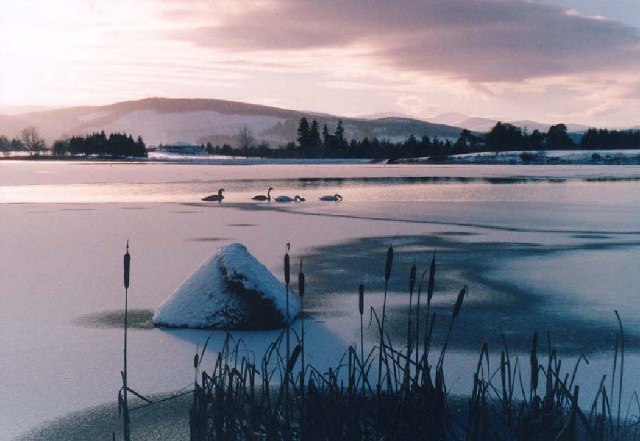
Loch of Aboyne

Loch of Aboyne is a shallow, artificial formed, freshwater loch in Grampian, Scotland. It lies 1+1⁄4 miles (2 km) northeast of Aboyne and 28 miles (45...

Nearby Amenities

Located within 500m of 57.086136,-2.7359674
Restaurant
The White Cottage
Addr Postcode: AB34 5BP
Website: http://www.whitecottage.eu
Lat/Long: 57.08783/-2.7343749
Material: wood
Power: pole
Lat/Long: 57.0879106/-2.7297312
Material: wood
Power: pole
Lat/Long: 57.0871381/-2.7312537
Material: wood
Power: pole
Lat/Long: 57.0869911/-2.7315561
Material: wood
Power: pole
Lat/Long: 57.0864366/-2.732656
Material: wood
Power: pole
Lat/Long: 57.0858822/-2.7337524
Power: pole
Lat/Long: 57.0853528/-2.7348346
Power: pole
Lat/Long: 57.0845927/-2.7363271
Power: pole
Lat/Long: 57.0839979/-2.7374942
Power: pole
Lat/Long: 57.0833963/-2.7387303
Power: pole
Lat/Long: 57.0828005/-2.7399274
Power: pole
Lat/Long: 57.0820221/-2.7348496
Power: pole
Lat/Long: 57.0827092/-2.7351025
Power: pole
Lat/Long: 57.0833454/-2.7354951
Power: pole
Lat/Long: 57.0839546/-2.7359071
Material: wood
Power: pole
Lat/Long: 57.0846465/-2.7292564
Material: wood
Power: pole
Lat/Long: 57.0853038/-2.7295888
Material: wood
Power: pole
Lat/Long: 57.08601/-2.7299832
Material: wood
Power: pole
Lat/Long: 57.0866009/-2.7303209
Power: pole
Lat/Long: 57.0871414/-2.7319451
Power: pole
Lat/Long: 57.0874393/-2.7328576
Power: pole
Lat/Long: 57.087618/-2.7339982
Material: wood
Power: pole
Lat/Long: 57.0877602/-2.7350362
Material: wood
Power: pole
Lat/Long: 57.0878419/-2.7356869
Broomfield
Place: locality
Lat/Long: 57.0857265/-2.7360819
The data included in this document is from www.openstreetmap.org. The data is made available under ODbL.

Have you been to Boddomend Wood?

Leave your review of Boddomend Wood below (or comments, questions and feedback).