Tyntesfield Park

Downs, Moorland in Somerset

England

Tyntesfield Park

Backwell: Teague’s Colliery The waste tip of an early 19th century coal mine on Backwell Common, now covered in trees. James Teague (1750-1818), its developer, was an ironmaster and owner of coal pits in the Forest of Dean. For further information see Ralph Anstis, The Industrial Teagues and the Forest of Dean, Allan Sutton, 1990. Seen from one of the numerous public footpaths in the parish
Backwell: Teague’s Colliery Credit: Martin Bodman

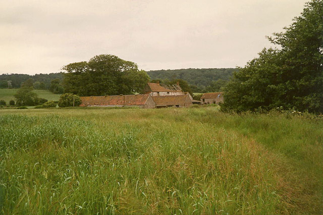
Tyntesfield Park is an expansive estate located in Somerset, England, encompassing both downs and moorland landscapes. Situated near the village of Wraxall, the park covers an impressive area of over 500 acres. It is renowned for its stunning natural beauty and rich history.

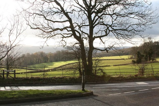
The downs of Tyntesfield Park boast rolling hills covered in lush grasslands, offering breathtaking panoramic views of the surrounding countryside. The area is home to a diverse range of flora and fauna, including wildflowers, butterflies, and various bird species. Walking trails meander through the downs, providing visitors with the opportunity to explore and immerse themselves in the tranquil surroundings.

In contrast, the moorland of Tyntesfield Park showcases a different aspect of the estate's landscape. Here, visitors can discover rugged terrain, characterized by open expanses of heather and gorse. The moorland offers a unique habitat for a variety of wildlife, such as deer and rare bird species.

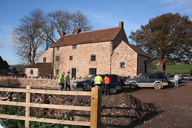
Aside from its natural splendor, Tyntesfield Park is famous for its stately home, which dates back to the Victorian era. The mansion, built in a Gothic Revival style, is a testament to the wealth and opulence of its former owners. It features intricate architectural details, grand halls, and beautifully landscaped gardens.

Today, Tyntesfield Park is open to the public, allowing visitors to explore the estate's grounds, gardens, and the stately home. The park serves as a popular destination for nature lovers, history enthusiasts, and those seeking a peaceful escape in the heart of Somerset's countryside.

If you have any feedback on the listing, please let us know in the comments section below.

Tyntesfield Park Images

Images are sourced within 2km of 51.438629/-2.7222899 or Grid Reference ST4971. Thanks to Geograph Open Source API. All images are credited.

Backwell: Teague’s Colliery The waste tip of an early 19th century coal mine on Backwell Common, now covered in trees. James Teague (1750-1818), its developer, was an ironmaster and owner of coal pits in the Forest of Dean. For further information see Ralph Anstis, The Industrial Teagues and the Forest of Dean, Allan Sutton, 1990. Seen from one of the numerous public footpaths in the parish
Backwell: Teague’s Colliery
The waste tip of an early 19th century coal mine on Backwell Common, now covered in trees. James Teague (1750-1818), its developer, was an ironmaster and owner of coal pits in the Forest of Dean. For further information see Ralph Anstis, The Industrial Teagues and the Forest of Dean, Allan Sutton, 1990. Seen from one of the numerous public footpaths in the parish
Wraxall (Somerset) All Saints Church Destined to get many more visitors since Tyntesfield in the village was acquired and opened by the National Trust
Wraxall (Somerset) All Saints Church
Destined to get many more visitors since Tyntesfield in the village was acquired and opened by the National Trust
Wraxall: footpath to Watercress Farm The path runs from Backwell Bow and crosses the Land Yeo on or near the site of the vanished Backwell Mill. Watercress Farm looks derelict here. It had suffered a fire. A leat system and headpond powered a small waterwheel in a hut by the farm in 1988, purpose not known, but possibly with the wheel working as a water pump
Wraxall: footpath to Watercress Farm
The path runs from Backwell Bow and crosses the Land Yeo on or near the site of the vanished Backwell Mill. Watercress Farm looks derelict here. It had suffered a fire. A leat system and headpond powered a small waterwheel in a hut by the farm in 1988, purpose not known, but possibly with the wheel working as a water pump
Moat Cottages
Moat Cottages
Stoney Steep Lane
Stoney Steep Lane
Cold Harbour Systems, The Courtyard Wraxall Weblink: <span class="nowrap"><a title="http://www.coldharbour-systems.co.uk/" rel="nofollow ugc noopener" href="http://www.coldharbour-systems.co.uk/">Link</a><img style="margin-left:2px;" alt="External link" title="External link - shift click to open in new window" src="https://s1.geograph.org.uk/img/external.png" width="10" height="10"/></span>
Cold Harbour Systems, The Courtyard Wraxall
Weblink: LinkExternal link
Expanding Nailsea Fields on the outskirts of the ever growing Nailsea, new built houses in the background
Expanding Nailsea
Fields on the outskirts of the ever growing Nailsea, new built houses in the background
The Tree at Wraxall, Wraxall Hill. The location is known locally as The Tree at Wraxall, it is the site of the old Market Cross, old deeds show that Wraxall used to hold a market and was called a Town.
The  tree is at the junction of Parsonage Lane which joins the B3128 and B3130, and close to Wraxall church.
The Tree at Wraxall, Wraxall Hill.
The location is known locally as The Tree at Wraxall, it is the site of the old Market Cross, old deeds show that Wraxall used to hold a market and was called a Town. The tree is at the junction of Parsonage Lane which joins the B3128 and B3130, and close to Wraxall church.
Wraxall: Watercress Farm The farm at one time belonged to the Tyntesfield estate, now National Trust. The farmhouse has been rebuilt following a fire in the 1980s. Work is now in progress to convert outbuildings. Two little water-powered pump houses here provided water for Tyntesfield House. Looking north west
Wraxall: Watercress Farm
The farm at one time belonged to the Tyntesfield estate, now National Trust. The farmhouse has been rebuilt following a fire in the 1980s. Work is now in progress to convert outbuildings. Two little water-powered pump houses here provided water for Tyntesfield House. Looking north west
Wraxall's only supermarket Almost exactly on the boundary between Nailsea and Wraxall, this combined petrol station is also a mini-supermarket.
Wraxall's only supermarket
Almost exactly on the boundary between Nailsea and Wraxall, this combined petrol station is also a mini-supermarket.
Vetco Gray - Nailsea Manufacturers of Sub-Sea Control Systems
Vetco Gray - Nailsea
Manufacturers of Sub-Sea Control Systems
Entrance to Footpath through former Orchards This is the way into a series of green spaces occupying the former orchards of the old cider factory.
Entrance to Footpath through former Orchards
This is the way into a series of green spaces occupying the former orchards of the old cider factory.
Old Oak tree at boundary of former orchard This tree near the boundary of a former orchard is old enough that it must have been present through the years that the area was an orchard - one can't help wondering how it survived.
Old Oak tree at boundary of former orchard
This tree near the boundary of a former orchard is old enough that it must have been present through the years that the area was an orchard - one can't help wondering how it survived.
Sawyers Arms - Nailsea As one heads east this is the last public house in High St, Nailsea before reaching the boundary with Wraxall.
Sawyers Arms - Nailsea
As one heads east this is the last public house in High St, Nailsea before reaching the boundary with Wraxall.
Must be a short footpath Actually it is, as it leads from Trendlewood Way, through one of the green areas left by the new construction to the recreation ground on Station Road.
Must be a short footpath
Actually it is, as it leads from Trendlewood Way, through one of the green areas left by the new construction to the recreation ground on Station Road.
I guess there have been problems with golfers Not a sign I have seen before, a lot more specific than 'No Ball Games' usually seen.
I guess there have been problems with golfers
Not a sign I have seen before, a lot more specific than 'No Ball Games' usually seen.
Green Space between houses Following the sign, (see <a href="https://www.geograph.org.uk/photo/1411222">ST4870 : Must be a short footpath</a>), you encounter a nice green space, but you mustn't practice your golf, see <a href="https://www.geograph.org.uk/photo/1411228">ST4870 : I guess there have been problems with golfers</a>.
Green Space between houses
Following the sign, (see ST4870 : Must be a short footpath), you encounter a nice green space, but you mustn't practice your golf, see ST4870 : I guess there have been problems with golfers.
Wraxall Hill into Nailsea Valley
Show me another place!

Tyntesfield Park is located at Grid Ref: ST4971 (Lat: 51.438629, Lng: -2.7222899)

Unitary Authority: North Somerset

Police Authority: Avon and Somerset

What 3 Words

///ages.atoms.chemistry. Near Nailsea, Somerset

Related Wikis

Wraxall and Failand

Wraxall and Failand, formerly just Wraxall is a civil parish in the North Somerset district, in the ceremonial county of Somerset, England. It includes...

Wraxall, Somerset

Wraxall is a village in North Somerset, England, about 6 miles (10 km) west of Bristol. Until 1811 the parish of the same name also included Nailsea and...

Tyntesfield

Tyntesfield (TINTS-feeld) is a Victorian Gothic Revival country house and estate near Wraxall, North Somerset, England. The house is a Grade I listed building...

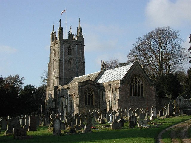
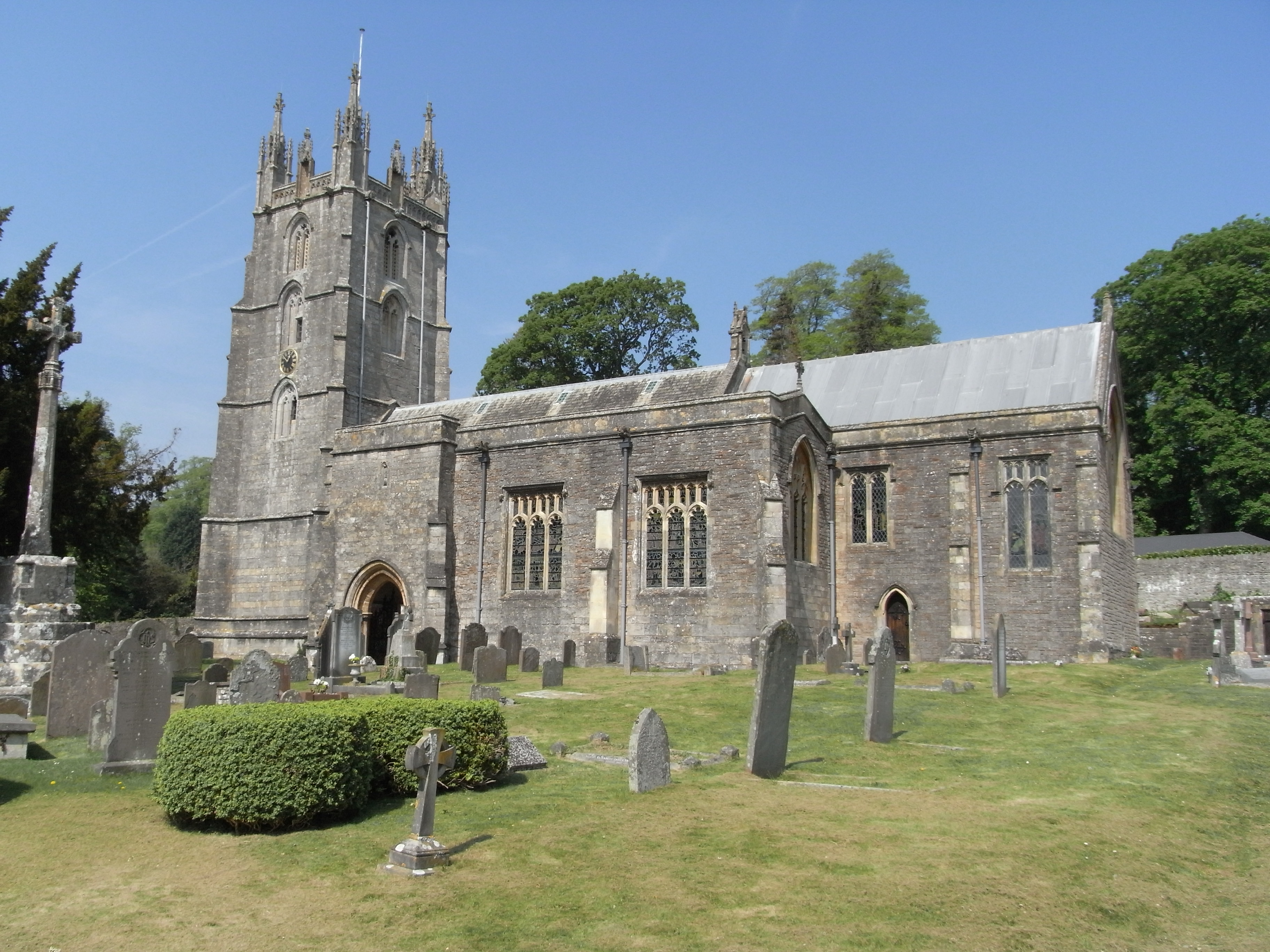
All Saints Church, Wraxall

All Saints' Church is the parish church in Wraxall, Somerset, England. It has been dedicated "to all the Saints". The building is surrounded by an extensive...

Nearby Amenities

Located within 500m of 51.438629,-2.7222899
Bus Stop
Battle Axes
Naptan AtcoCode: 0190NSC30702
Naptan Bearing: SE
Naptan CommonName: Battle Axes
Naptan Crossing: Bristol Road
Naptan NaptanCode: wsmgwmt
Naptan Street: The Grove
Shelter: no
Source: naptan_import
Lat/Long: 51.4409055/-2.728136
Bus Stop
Battle Axes
Naptan AtcoCode: 0190NSC30703
Naptan Bearing: N
Naptan CommonName: Battle Axes
Naptan NaptanCode: wsmgwmw
Naptan Street: The Grove
Shelter: yes
Source: naptan_import
Lat/Long: 51.4406828/-2.7279038
Bus Stop
Wraxall Lodge
Bus: yes
Naptan AtcoCode: 0190NSC30704
Naptan Bearing: NW
Naptan CommonName: Wraxall Lodge
Naptan NaptanCode: wsmgwtp
Naptan Street: B3130
Public Transport: platform
Shelter: no
Source: naptan_import
Lat/Long: 51.436089/-2.7213217
Bus Stop
Lower Lodge
Bus: yes
Naptan AtcoCode: 0190NSC30705
Naptan Bearing: W
Naptan CommonName: Lower Lodge
Naptan NaptanCode: wsmjadt
Naptan Street: B3130
Public Transport: platform
Shelter: no
Source: naptan_import
Lat/Long: 51.4352054/-2.7186727
Wraxall TV Repeater
Man Made: tower
Lat/Long: 51.4420341/-2.722881
Barrier: stile
Foot: yes
Lat/Long: 51.4384125/-2.7294798
Power: pole
Source: Bing
Lat/Long: 51.4357617/-2.7261586
Power: pole
Source: Bing
Lat/Long: 51.4366115/-2.7259591
Power: pole
Source: Bing
Lat/Long: 51.4374113/-2.7257727
Power: pole
Source: Bing
Lat/Long: 51.4383127/-2.7255747
Barrier: stile
Foot: no
Lat/Long: 51.4390796/-2.7263591
Crossing
Crossing: uncontrolled
Crossing Ref: zebra
Tactile Paving: no
Lat/Long: 51.4415909/-2.71933
Toilets
Access: customers
Level: 1
Lat/Long: 51.4422818/-2.7186629
Drinking Water
Lat/Long: 51.4423451/-2.7187106
Shop: books
Lat/Long: 51.4423357/-2.7183706
Shop: garden_centre
Lat/Long: 51.4422964/-2.7185355
Crossing
Crossing: uncontrolled
Crossing Ref: zebra
Tactile Paving: no
Lat/Long: 51.4418829/-2.7198739
Crossing
Crossing: uncontrolled
Crossing Ref: zebra
Tactile Paving: no
Lat/Long: 51.4418222/-2.7200666
Crossing
Crossing: uncontrolled
Crossing Ref: zebra
Tactile Paving: no
Lat/Long: 51.441737/-2.7203374
Crossing
Crossing: uncontrolled
Crossing Ref: zebra
Tactile Paving: no
Lat/Long: 51.441672/-2.7205438
Crossing
Crossing: uncontrolled
Crossing Ref: zebra
Tactile Paving: no
Lat/Long: 51.4416057/-2.7207542
Crossing
Crossing: uncontrolled
Crossing Ref: zebra
Tactile Paving: no
Lat/Long: 51.4415262/-2.7195364
Crossing
Crossing: uncontrolled
Crossing Ref: zebra
Tactile Paving: no
Lat/Long: 51.4414478/-2.7197769
Crossing
Crossing: uncontrolled
Crossing Ref: zebra
Tactile Paving: no
Lat/Long: 51.4413612/-2.7200423
Crossing
Crossing: uncontrolled
Crossing Ref: zebra
Lat/Long: 51.4412895/-2.720256
Crossing
Crossing: uncontrolled
Crossing Ref: zebra
Lat/Long: 51.4412279/-2.7204731
Entrance: staircase
Lat/Long: 51.4397826/-2.7271354
Entrance: staircase
Lat/Long: 51.4398576/-2.7273334
Fire Hydrant
Emergency: fire_hydrant
Fire Hydrant Diameter: 75
Fire Hydrant Position: lane
Fire Hydrant Type: underground
Lat/Long: 51.4390024/-2.7289831
Man Made: street_cabinet
Lat/Long: 51.4406917/-2.7279087
Grit Bin
Lat/Long: 51.440662/-2.727881
Waste Basket
Lat/Long: 51.4406734/-2.7278916
Fire Hydrant
Emergency: fire_hydrant
Fire Hydrant Diameter: 100
Fire Hydrant Position: lane
Fire Hydrant Type: underground
Lat/Long: 51.4406988/-2.7278109
Barrier: cycle_barrier
Lat/Long: 51.4408808/-2.7280472
Barrier: kissing_gate
Lat/Long: 51.4355091/-2.7201192
The data included in this document is from www.openstreetmap.org. The data is made available under ODbL.

Have you been to Tyntesfield Park?

Leave your review of Tyntesfield Park below (or comments, questions and feedback).